|
2024 Permanent/Temporary/Preliminary UKHO Notices to Mariners - |
||
|
Week 52 |
ENGLAND - Insert:
Notice 5883 refers The base image courtesy of Imray Chart IN5037 and Meridian Chartware.
|
Affects: UKHO SNC: 1185. UKHO SCC: 5606.7 Imray Full Charts: C2 Imray Leisure Charts: C2100.2 and C2100.1 One new FOUL (position approximate) reported in 2024 has been found in the Southend Deep Water Anchorage in Sea Reach, River Thames. Unlikely to hinder leisure craft.
|
|
Week 52 |
ENGLAND - The starboard- Former Position New Position 51° 28´·67N., 0° 44´·15E. 51° 28´·87N., 0° 43´·32E. Mariners are advised to navigate with caution in the area. Notice 5855(T) refers The base image courtesy of Imray Chart IN5037 and Meridian Chartware.
|
Affects: UKHO SNC: 1185 and 3683. UKHO SCC: 5606.7, 5606.8 and 5606.9 Imray Full Charts: C2 Imray Leisure Charts: C2100.2 and C2100.1 The Mid Swatch starboard hand buoy marking the south side of the Nore Sand has been moved approx. 0.6nm 290°(T). Worth noting.
|
|
Week 52 |
ENGLAND - Insert:
Automatic Identification System, AIS: at light- Notice 5942 refers The base image courtesy of Imray Chart C1 and Meridian Chartware.
|
Affects: UKHO SNC: 1406, 1408, 1610 and 1630. UKHO SCC: 5607.1 Imray Full Charts: C1 A new lit Superbuoy has been placed north of the Sunk E TSS corridor (east of the Galloper Wind Farm). This is within the location of the intended Five Estuaries Offshore Wind Farm.
|
|
Week 52 |
EAST COAST OF ENGLAND - Amendment: Moved to new assigned position: Latitude 52˚ 40.293’N., Longitude 001˚ 53.737’E. No further notice will be given. Trinity House No 30 of 2024 refers The base image courtesy of Imray Chart C28 and Meridian Chartware.
|
Affects: UKHO SNC: 1534, 1535 and 1543. UKHO SCC: 5614.1, 5614.2, 5614.3, 5614.4 and 5614.5. Imray Full Charts: C28 Trinity House has reported today that the East Cross lighted buoy marking the eastern side of the Middle Cross Sand has been moved. The extent of the move is quite small so difficult (but not impossible) to illustrate!
|
|
Week 51 |
ENGLAND - The isolated danger light- Mariners are advised to navigate with caution in the area and consult the local port authorities for the latest information. Notice 5751(T) refers base image courtesy of Imray Chart Y9 and Meridian Chartware.
|
Affects: UKHO SNC: 108 and 1190. UKHO SCC: 5614.8 and 5614.9. Imray Full Charts: Y9 The unnamed isolated danger light buoy in the Well in the Wash is off station at present.
|
|
Week 51 |
BELGIUM - Insert: limit of restricted area, entry prohibited, pecked line, joining: 51° 10´·50N., 2° 37´·12E. 51° 10´·74N., 2° 38´·01E. 51° 09´·87N., 2° 38´·60E. 51° 09´·61N., 2° 37´·72E. Delete: former limit of restricted area, entry prohibited, pecked line, joining: 51° 10´·59N., 2° 36´·78E. 51° 10´·96N., 2° 38´·14E. 51° 09´·79N., 2° 38´·94E. 51° 09´·40N., 2° 37´·59E. Move: Q ZB9- Q ZB1- Q(6)+LFl.15s ZB4- Q(6)+LFl.15s ZB6- Chart 1873 Insert the accompanying block, centred on: 51° 10´·2N., 2° 38´·1E. Notice 5774 refers Base image courtesy of Imray Chart C2120.3 and Meridian Chartware. The UKHO block is copyright of the UKHO.
|
Affects: UKHO SNC: 1872. 1873 and 2449. UKHO SCC: 5605.11 Imray Full Charts: C30 Imray Leisure Charts: C2120.3 A restricted area to the north-
|
|
Week 50 |
ENGLAND - Insert: depth, 9.3, and extend 10m approximate contour W to enclose 52° 39´·71N., 1° 46´·38E. depth, 10.6, and extend 15m contour W to enclose 52° 39´·89N., 1° 46´·31E. Delete depth, 16.1, close SW. depth, 9.1, and extend 10m approximate contour NW to enclose 52° 40´·09N., 1° 46´·53E. Delete depth, 10.8, close N. depth, 11.1 at 52° 40´·28N., 1° 46´·49E. Delete depth, 13.4, close NW. depth, 13.9, and extend 15m approximate contour NW to enclose 52° 40´·44N., 1° 46´·43E. Delete depth, 16.8, close NW. Notice 5664 refers The base image courtesy of Imray Chart C28 and Meridian Chartware.
|
Affects: UKHO SNC: 1534 and 1543. UKHO SCC: 5614.5 (Panel A, Northern Approaches to Great Yarmouth), 5614.2 and 5614.6 (Panel A, Caister- Imray Full Charts: C28 Five new reduced depths in the Caister Road between the NW and Mid Scroby SHBs. The depths are unlikely to hinder leisure craft. The image includes changes reported in 4 previous permanent Notices and one preliminary Notice this year.
|
|
Week 50 |
ENGLAND - Note: Former Notice 4414(P)/24 is cancelled. Insert: depth, 13.1 at 51° 46´·38N., 1° 23´·28E. Delete depth, 14.5, close S. depth, 2.5, and extend 5m contour NW to enclose 51° 45´·50N., 1° 28´·50E. Delete depth, 12.1, close NW. depth, 13.8 at 51° 42´·87N., 1° 22´·20E. Delete depth, 14.2, close W. depth, 1.5, enclosed by 2m contour at 51° 45´·27N., 1° 28´·29E. depth, 11.3 at 51° 45´·73N., 1° 21´·63E. Delete depth, 14.4, close SE. depth, 2.5, and extend 5m contour SE to enclose 51° 45´·65N., 1° 21´·01E. Delete depth, 9, close S. depth, 1.3, and extend 2m contour SE to enclose 51° 45´·59N., 1° 20´·72E. Delete depth, 1.4, close NE. depth, 5.5, and extend 10m contour NW to enclose 51° 45´·29N., 1° 28´·19E. Delete depth, 13, close W. Replace: depth, 9.6, with depth, 7.7 at 51° 41´·23N., 1° 22´·36E. Notice 5704 refers The base image courtesy of Imray Chart C1 and Meridian Chartware.
|
Affects: UKHO SNC: 1183, 1975 and 2692. UKHO SCC: 5607.3, 5607.4 and 5607.2. Imray Full Charts: C1 Imray Leisure Folios 2000.1 This notice confirms Preliminary Notice 4414(P)/24 which reported reduced depths at the Sunk Head and around the Gunfleet Spit SCB. The notice confirms 7 of the reported depths and amends two at the Sunk Head. That suggests cutting across the Sunk Head when you are confident of the height of tide. The image includes three revised depths on the Little Sunk which was reported vide NtM 1026 earlier this year.
|
|
Week 50 |
ENGLAND - Insert: depth, 9, and extend 10m contour E to enclose 52° 34´·613N., 1° 44´·801E. Notice 5711 refers The base image courtesy of Imray Chart C28C and Meridian Chartware.
|
Affects: UKHO SNC: 1534 (Panel A, Great Yarmouth Outer Harbour). UKHO SCC: 5614.4(Panel B, Great Yarmouth Outer Harbour). Imray Full Charts: C28C A revised depth at the south entrance of the Great Yarmouth outer harbour. Ample water for a leisure craft and not where we ought to be. The image includes revised depths from NtM 2873 earlier this year.
|
|
Week 50 |
ENGLAND - Works are in progress at the Oikos Jetty No.1, until approximately 15th February 2025, in an area bounded by the following positions: 51° 30´·593N., 0° 33´·237E. 51° 30´·625N., 0° 33´·244E. and 51° 30´·596N., 0° 33´·437E. 51° 30´·489N., 0° 33´·412E. 51° 30´·513N., 0° 33´·220E. 51° 30´·587N., 0° 33´·235E. Mariners are advised to navigate with caution in the area. Notice 5715(T) refers The image courtesy of the Port of London Authority.
|
Affects: UKHO SNC: 1185 and 1186. UKHO SCC: 5606.8. Imray Full Charts: C2 Imray Leisure Folios 2100.3 This notice duplicates the local PLA Notice No L74 reporting long term works at the Oikos Jetty in the Sea Reach of the River Thames. The area of works are on commercial jetties but are adjacent to the entrance at Holehaven Creek and would need care to be avoided.
|
|
Week 49 |
ENGLAND - Insert: depth, 6.5 at 52° 32´·70N., 1° 48´·55E. Delete depth, 7.3, close S and depth 7.6 close NW. depth, 5.8 at 52° 32´·49N., 1° 48´·74E. Delete depth, 6.9, close N. depth, 4.7, enclosed by 5m contour at 52° 32´·33N., 1° 48´·80E. Delete depth, 6.6, close NE, depth, 5.3, close S and depth, 6.9, close NW. Notice 5473 refers The base image courtesy of Imray Chart C28 and Meridian Chartware.
|
Affects: UKHO SNC: 1534, 1535 and 1543. UKHO SCC: 5614.3, 5614.4 (Panel A, Approaches to Great Yarmouth and 5614.2. Imray Full Charts: C28 Continued changes in the southern entrance of the Holm Channel (to Great Yarmouth). Three reduced depths there but ample water for leisure craft. The chartlet includes previous changes this year including the moves of the S. Corton cardinal and NE Holm PH buoys.
|
|
Week 49 |
ENGLAND - Insert: depth, 2.4 at 51° 46´·27N., 1° 09´·48E. Delete depth, 3.2, close S.
depth, 0, enclosed by 0m low water line at 51° 45´·84N., 1° 21´·30E. Delete depth 1.5, close W. depth, 1.3 at 51° 47´·78N., 1° 23´·73E. Delete depth, 1.9, close S. depth, 3.3 at 51° 48´·55N., 1° 24´·87E. Delete depth, 4.5, close SW. depth, 5.2 at 51° 50´·34N., 1° 19´·63E. Delete depth, 5.8, close NW. depth, 0.7 at 51° 50´·87N., 1° 16´·96E. Delete depth, 1.3, close NE. Replace:
Notice 5480 refers The base image courtesy of Imray Chart C1 and Meridian Chartware.
|
Affects: UKHO SNC: 1183, 1975 and 2052. UKHO SCC: 5607.3, 5607.4and 5607.2. Imray Full Charts: C1 Imray Leisure Folios 2000.1 Four revised reduced depths over wrecks, six reduced depths and on new wreck and one new obstruction in the Wallet and on the Gunfleet Sands. There is a general trend of reduced depths on the NE tail of the Gunfleet Sands, indeed earlier this year a UK block was issued vide NtM 3694/24 in week 32. The block is slightly amended by this notice. There have been several notices of other reductions of depths so the image incorporates all the changes reported. Two images.
|
|
Week 49 |
BELGIUM - Insert: limit of reclamation area, pecked line, joining: 51° 18´·973N., 3° 06´·340E. 51° 18´·971N., 3° 06´·352E. 51° 18´·957N., 3° 06´·376E. 51° 18´·878N., 3° 06´·468E. and 51° 18´·913N., 3° 06´·340E. 51° 18´·862N., 3° 06´·417E. 51° 18´·764N., 3° 06´·634E. 51° 18´·762N., 3° 06´·651E. legend, Being reclaimed (2024), centred on: 51° 18´·825N., 3° 06´·487E. fog signal, Horn Mo(U)30s, at light 51° 18´·909N., 3° 06´·561E. Delete: charted detail within the reclamation area. Move:
Notice 5462 refers The base image courtesy of Imray Chart C2120+4 and Meridian Chartware.
|
Affects: UKHO SNC: 1872 (Panel, Blankenberge). UKHO SCC: 5605.11 Imray Full Charts: C30 Imray Leisure Folios 2120+4 This Notice should be read in conjunction with Notice 5349 in week 47 which variously reports land reclamation and a prohibitive area on the western side of the Blankenberge Harbour entrance. The new east cardinal buoy reported in week 47 is moved slightly to the west and the addition of a fog signal at the current western arm of the harbour entrance.
|
|
Week 49 |
ENGLAND - Insert:
51° 27´·960N., 0° 18´·380E. and 51° 27´·894N., 0° 18´·295E. Notice 5503 refers The base image courtesy of Imray Chart IN5036 and Meridian Chartware.
|
Affects: UKHO SNC: 2151. UKHO SCC: 5606.14A Imray Full Charts: C2 Imray Leisure Folios 2100.3 Two new ship’s moorings in Fiddlers Reach of the River Thames close by Broadness Saltings.
|
|
Week 48 |
ENGLAND - Insert: the accompanying block, centred on: 52° 28´·5N., 1° 44´·2E. Notice 5366 refers Block is copyright of the UKHO.
|
Affects: UKHO SNC: 1535 Imray Full Charts: C28 Imray Leisure Folios 2000.10 A further Block from UKHO for the area of the Gull Wing Bridge in Lowestoft. Notice 5232 in week 46 provided two blocks in the same area, one for the Panel in the SNC and the other for the SCC. This block is the block for the main part of the SNC (i.e. good scale!).
|
|
Week 48 |
DOVER STRAIT - Insert: depth, 28.5 at 51° 08´·18N., 1° 40´·06E. Delete depth, 29.5, close N. depth, 27 at 51° 08´·55N., 1° 40´·91E. Delete depth, 28.5, close N. depth, 27.5 at 51° 13´·50N., 1° 44´·41E. Delete depth, 28.5, close N. Replace: depth, 28, with depth, 27 at 51° 09´·49N., 1° 41´·36E. depth, 26.5, with depth, 25.5 at 1° 08´·37N., 1° 40´·35E and delete depth, 27.5, close NW. Notice 5368 refers The base image courtesy of Imray Chart IN5007 and Meridian Chartware.
|
Affects: UKHO SNC: 323, 1406, 1610, 1892 and 2449. UKHO SCC: 5605.2, 5605.1 (Panel B, Approaches to Dover Straits) and 5606.1. Note: This update is included in New Edition 5606.3, published late 2024. Imray Full Charts: C8 Imray Leisure Folios 2100.1 Five reductions of depth in the SW going TSS twixt the South Falls south cardinal buoy and the MPC yellow special buoy. Very unlikely to hinder leisure craft at those depths! The image includes three other reduced depths reported in NtM 5161 in week 45.
|
|
Week 47 |
ENGLAND - Replace:
Notice 5296 refers The base image courtesy of Imray Chart IN5016 and Meridian Chartware.
|
Affects: UKHO SNC: 1185, 1834, 2482 and 3683. UKHO SCC: 5606.10 (Panel A, Mouth of River Medway and West Swale) and 5606.9. Imray Full Charts: Y18 Imray Leisure Folios 2100.3 and 2100.5 This notice confirms the Medway (ABP Ports) notice of the removal of the two ships moorings (Nos 1 and 2) west of Queenborough Spit and inserting two FOUL in place. The Medway notice reported that the old mooring chains had been left in place, hence the two FOUL.
|
|
Week 47 |
ENGLAND - Chart 2052 Insert the accompanying block, centred on: 51° 58´·6N., 1° 23´·8E. Chart 2693 Insert the accompanying block, centred on: 51° 58´·6N., 1° 23´·3E. Chart 5607.6 (Panel A, Approaches to Harwich and Woodbridge Haven) Insert the accompanying block, centred on: 51° 58´·5N., 1° 23´·4E. Chart 5607.5 Insert the accompanying block, centred on: 51° 58´·6N., 1° 23´·8E. Notice 5305 refers The blocks are copyright of the UKHO.
|
Affects: UKHO SNC: 2052 and 2693. UKHO SCC: 5607.6 (Panel A, Approaches to Harwich and Woodbridge Haven) and 5607.5. Imray Full Charts: Y16. Imray Leisure Folios 2000.3 Four new UKHO blocks for the Woodbridge Haven (Deben Entrance); each four variations of the same area for the two SNC and two SCC chart. UKHO does not display the buoyage beyond the SWB so refer to: https://www.eastcoastpilot.com/downloads for the Imray/East Coast Pilot detailed chartlets. The image is from the UKHO downloads:
|
|
Week 47 |
ENGLAND - Insert: depth, 2.5, and extend 5m contour S to enclose 51° 23´·99N., 1° 19´·34E. Replace:
depth, 1.8, with depth, 0.5 at 51° 24´·12N., 1° 13´·62E. Notice 5330 refers The base image courtesy of Imray Chart C1 and Meridian Chartware.
|
Affects: UKHO SNC: 323, 1183, 1607 and 1828. UKHO SCC: 5606.4 and 5606.2. Imray Full Charts: C1 Imray Leisure Folios 2100.1 and 2100.7 This Notice confirms Preliminary Notice 4581(P) earlier this year reporting a reduction of depth over an existing wreck and two depths on the south side of the Margate Hook.
|
|
Week 47 |
ENGLAND - Insert: depth, 9.2 at 52° 34´·20N., 1° 45´·06E. Delete depth, 9.7, close E. Notice 5347 refers The base image courtesy of Imray Chart C28 and Meridian Chartware.
|
Affects: UKHO SNC: 1534 and 1535. UKHO SCC: 5614.3 and 5614.4 (Panel A, Approaches to Great Yarmouth). Imray Full Charts: C28 One reduction of depth on the southeast approaches to Great Yarmouth. Unlikely to hinder leisure craft.
|
|
Week 47 |
BELGIUM - Insert: limit of restricted area, entry prohibited, pecked line, joining: 51° 18´·89N., 3° 06´·17E. 51° 18´·99N., 3° 06´·32E. 51° 18´·93N., 3° 06´·42E. 51° 18´·88N., 3° 06´·47E.
Move:
Delete former limit of restricted area, entry prohibited, pecked line, joining: 51° 18´·89N., 3° 06´·17E., 51° 19´·04N., 3° 06´·10E. and 51° 18´·88N., 3° 06´·47E. Notice 5349 refers The base image courtesy of Imray Chart C2120.4A and Meridian Chartware.
|
Affects: UKHO SNC: 1872 (Panel Blankenberge), 1872 and 1874. UKHO SCC: 5605.11. Imray Full Charts: C30 Imray Leisure Folios 2120.4A The restricted area just to the west of the entrance to Blankenberge harbour has been redefined and marked by a moved north cardinal beacon and east cardinal buoy.
|
|
Week 46 |
ENGLAND - Insert:
Notice 5180 refers The base image courtesy of Imray Chart Y16G and Meridian Chartware.
|
Affects: UKHO SNC: 1491 UKHO SCC: 5606.14 (Panel B. Erith Reach to Hook Ness). Imray Full Charts: Y16 and Y16G Imray Leisure Folios 2000.5E New FOUL close in shore north of the entrance into Shotley Marina.
|
|
Week 46 |
ENGLAND - Recent survey information has shown that depths less than charted exist within the vicinity of Lowestoft and Approaches. The most significant are as follows: Depth Position 6·5m 52° 32´·32N., 1° 49´·03E. 9·4m 52° 30´·22N., 1° 49´·76E. 9·4m 52° 32´·95N., 1° 48´·69E. 9·4m 52° 32´·29N., 1° 49´·15E. 9·4m 52° 33´·63N., 1° 47´·73E. 4·4m 52° 28´·332N., 1° 45´·729E. 1·4m 52° 28´·270N., 1° 45´·681E. 1·2m 52° 27´·86N., 1° 45´·17E. 0·7m 52° 27´·74N., 1° 45´·03E. 1·4m 52° 27´·12N., 1° 44´·80E. 0·8m 52° 26´·59N., 1° 44´·79E. 4·4m 52° 26´·77N., 1° 46´·61E. 3·8m 52° 26´·53N., 1° 47´·22E. 1·4m 52° 25´·34N., 1° 44´·98E. 5·0m 52° 38´·01N., 1° 49´·52E. 10m 52° 38´·61N., 1° 49´·45E. 10m 52° 37´·38N., 1° 49´·42E. 30m 52° 37´·79N., 1° 49´·64E. 8·3m 52° 42´·03N., 1° 45´·80E. 13·9m 52° 41´·49N., 1° 46´·77E. 3·6m 52° 40´·73N., 1° 44´·52E. 0·8m 52° 40´·31N., 1° 44´·60E. 4·2m 52° 41´·30N., 1° 44´·88E. * 1·5m 52° 37´·78N., 1° 48´·99E. * 18·7m 52° 39´·03N., 1° 49´·32E. * 28·9m 52° 39´·58N., 1° 49´·46E. * 9·4m 52° 39´·80N., 1° 48´·43E. * 14·7m 52° 40´·54N., 1° 48´·25E. Mariners are advised to navigate with caution in the area. Charts will be updated when full details are available. Former Notice 5069(P)/24 is cancelled. * Indicates new or revised entry (ETRS89 DATUM) Notice 5165(P) refers The base image courtesy of Imray Chart C28 and Meridian Chartware.
|
Affects: UKHO SNC: 1534, 1535 and 1543. UKHO SCC: 5614.1, 5614.2, 5614.3, 5614.4, 5614.5 and 5614.6. Imray Full Charts: C28 This preliminary Notice is a continuation of the (almost weekly) series of preliminary notices advising reduced depths from Winterton Ness to Benacre Ness. This notice adds 5 further reduced depths on the eastern side of the Scroby sands. The image should be seen in conjunction with the image of last week vide NtM 5069(P).
|
|
Week 46 |
ENGLAND - Insert: the accompanying block, centred on: 52° 28´·5N., 1° 44´·1E. Notice 5232 refers The block is copyright of UKHO.
|
Affects: UKHO SNC: 1535 (Panel, Lowestoft Harbour) UKHO SCC: 5614.20 (Panel A, Lowestoft Harbour). Imray Full Charts: C28 Imray Leisure Folios 2000.10 The UKHO has issued two UKHO block covering the area of the Lowestoft Inner Harbour showing the new Gull Wing Bridge; one for the SNC and one for the relevant SCC.
|
|
Week 46 |
ENGLAND - Insert:
Notice 5235 refers The base image courtesy of Imray Chart IN5035 and Meridian Chartware.
|
Affects: UKHO SNC: 1185 and 3683. UKHO SCC: 5606.9 and 5606.10 (Panel A, Mouth of River Medway and West Swale). Imray Full Charts: C1 Imray Leisure Folios 2100.2 A new ‘obstn’ (at 2.9m) reported a little due west of the wreck of the SS Montgomery.
|
|
Week 46 |
FRANCE - Insert: depth, 15.7, and extend 20m contour NE to enclose 50° 58´·994N., 1° 45´·228E. depth, 8.5, enclosed by 10m contour 50° 58´·893N., 1° 45´·495E. depth, 8.2, enclosed by 10m contour 50° 58´·852N., 1° 45´·485E. Delete: depth, 14.3, and associated 15m contour at 50° 58´·718N., 1° 44´·774E. depth, 15, and associated 15m contour at 50° 58´·926N., 1° 45´·037E. Notice 5233 refers The base image courtesy of Imray Chart IN5007 and Meridian Chartware.
|
Affects: UKHO SNC: 1351 UKHO SCC: 5605.1 Panel B, 5605.2 and 5606.1. Imray Full Charts: C8 Imray Leisure Folios 2100.7 Three reduction of depth close east and south-
|
|
Week 46 |
ENGLAND - Insert depth, 5, and extend 5m contour SW to enclose 51° 32´·03N., 1° 00´·15E. Delete depth, 5.4, close SW. depth, 0.7, and extend 2m contour S to enclose 51° 32´·41N., 1° 01´·45E. Delete depth, 2.7, close SE and depth 1.2 close NE. depth, 1.6, and extend 2m contour S to enclose 51° 32´·44N., 1° 01´·59E. Delete depth, 2.7, close E and depth, 0.1, close NW.
Replace: depth, 5.5, with depth, 4.8, and extend 5m contour S to enclose 51° 32´·34N., 1° 01´·23E. Notice 5252 refers The base image courtesy of Imray Chart IN5043 and Meridian Chartware.
|
Affects: UKHO SNC: 1607 and 1609 UKHO SCC: 5606.6. Imray Full Charts: C1 Imray Leisure Folios 2100.1 This notice reports three reductions of depths close to the SW Barrow west cardinal buoy. We had an earlier Notice this year (1608) in week 15 and this notice amends some of those reductions. The message is that it is not good to cut inside the cardinal buoy to or from the West Swin without due regard.
|
|
Week 46 |
FRANCE - Insert:
Notice 5244 refers The base image courtesy of Imray Chart IN5007 and Meridian Chartware.
|
Affects: UKHO SNC: 1406, 1610, 1892 2449 and 5500. UKHO SCC: 5605.1 (Panel A, Western Approaches to Dover Strait), 5605.1 (Panel B, Northern approaches to Dover Strait), 5605.2 and 5606.1 Imray Full Charts: C8 Imray Leisure Folios 2100.7 A new Pilot Boarding Place for LPG bulk carriers in the Dunkerque Waiting Area. The location is adjacent to routes we might use between the East Goodwins and Calais.
|
|
Week 45 |
ENGLAND - Recent survey information has shown that depths less than charted exist within the vicinity of Lowestoft and Approaches. The most significant are as follows: Depth Position 6·5m 52° 32´·32N., 1° 49´·03E. 9·4m 52° 30´·22N., 1° 49´·76E. 9·4m 52° 32´·95N., 1° 48´·69E. 9·4m 52° 32´·29N., 1° 49´·15E. 9·4m 52° 33´·63N., 1° 47´·73E. 4·4m 52° 28´·332N., 1° 45´·729E. 1·4m 52° 28´·270N., 1° 45´·681E. 1·2m 52° 27´·86N., 1° 45´·17E. 0·7m 52° 27´·74N., 1° 45´·03E. 1·4m 52° 27´·12N., 1° 44´·80E. 0·8m 52° 26´·59N., 1° 44´·79E. 4·4m 52° 26´·77N., 1° 46´·61E. 3·8m 52° 26´·53N., 1° 47´·22E. 1·4m 52° 25´·34N., 1° 44´·98E. 5·0m 52° 38´·01N., 1° 49´·52E. 10m 52° 38´·61N., 1° 49´·45E. 10m 52° 37´·38N., 1° 49´·42E. 30m 52° 37´·79N., 1° 49´·64E. 8·3m 52° 42´·03N., 1° 45´·80E. 13·9m 52° 41´·49N., 1° 46´·77E. * 3·6m 52° 40´·73N., 1° 44´·52E. * 0·8m 52° 40´·31N., 1° 44´·60E. * 4·2m 52° 41´·30N., 1° 44´·88E. Mariners are advised to navigate with caution in the area. Charts will be updated when full details are available. Former notice 5018(P)/24 is cancelled. * Indicates new or revised entry. Notice 5069(P) refers The base image courtesy of Imray Chart C28 and Meridian Chartware.
|
Affects: UKHO SNC: 1534, 1535 and 1543. UKHO SCC: 5614.1, 5614.2, 5614.3, 5614.4, 5614.5 and 5614.6. Imray Full Charts: C28 This preliminary Notice is a continuation of the series of preliminary notices advising reduced depths from Winterton Ness to Benacre Ness. This notice adds 3 reduced depths at the Hemsby Hole and North Caister. The images includes all other reduced depths in the area reported this year.
|
|
Week 45 |
ENGLAND - Insert:
Move:
Delete: former Notice 5080 refers The base image courtesy of Imray Chart C28 and Meridian Chartware.
|
Affects: UKHO SNC: 1535 and 1543. UKHO SCC: 5614.1 (Panel A, Orford Ness to Benacre Ness), 5614.2 and 5614.3. Imray Full Charts: C28 This permanent notice is confirming buoy moves reported earlier by Trinity House (TH21 of 2024). The moves affected were the SW Holm SHB, South Holm SCB, Newcome Sand PHB and the Stanford PHB.
|
|
Week 45 |
ENGLAND - Insert: depth, 4.2 at 51° 30´·510N., 0° 05´·328E. Delete depth, 4.8, close SW. depth, 6 at 51° 30´·175N., 0° 04´·753E. Delete depth, 6.2, close SW. Notice 5114 refers The base image courtesy of Imray Chart IN5030 and Meridian Chartware.
|
Affects: UKHO SNC: 2151 (Panel A, Continuation at same scale) and 3337. UKHO SCC: 5606.14 (Panel B. Erith Reach to Hook Ness). Imray Full Charts: C2 Imray Leisure Folios 2100.4 Two reduction of depth in Gallions Reach, River Thames. Unlikely to hinder leisure craft.
|
|
Week 45 |
ENGLAND - Replace: depth, 4.5 , with depth, 4.4 at 51° 26´·726N., 0° 23´·769E. Notice 5123 refers The base image courtesy of Imray Chart IN5036 and Meridian Chartware.
|
Affects: UKHO SNC: 1186 (Panel B, Coalhouse Point to Tilbury). UKHO SCC: 5606.13 (Panel A, Hole Haven to Gravesend Reach). Imray Full Charts: C2 Imray Leisure Folios 2100.3 One reduction of depth in Gravesend Reach, River Thames, east of the entrance to the Embankment Marina. Unlikely to hinder leisure craft.
|
|
Week 45 |
ENGLAND - Insert:
Delete:
Notice 5131 refers The base image courtesy of Imray Chart Y9 and Meridian Chartware.
|
Affects: UKHO SNC: 1200 (Panel A, The Wash Eastern Part). UKHO SCC: 5614.10 (Pane A, The Wash, Eastern Part) Imray Full Charts: Y9 Establishment of a new Yellow special lit buoy in the channel to Kings Lynn. Back in July local notices reported the damage and loss of lit beacon ‘B’ following a collision with a fishing vessel. The yellow special buoy replaces the mark approximately 20 m south of the remains of the old beacon which is now regarded as ‘FOUL’ ground.
|
|
Week 45 |
DOVER STRAIT - Insert: depth, 18.9, and extend 20m contour SE to enclose 51° 14´·39N., 1° 44´·21E. depth, 18.5 at 51° 13´·79N., 1° 43´·52E. Delete depth, 19.5, close S. depth, 22. 5 at 51° 11´·27N., 1° 42´·72E. depth, 25 at 51° 10´·88N., 1° 42´·38E. Delete depth, 26.5, close NW. Replace: depth, 23.5, with depth, 22.5 at 51° 12´·13N., 1° 43´·29E. Notice 5161 refers The base image courtesy of Imray Chart IN5007 and Meridian Chartware.
|
Affects: UKHO SNC: 323, 1406, 1610 and 2449. UKHO SCC: 5605.2, 5605.1 (Panel B, Northern Approaches to Dover Strait), 5606.3 and 5606.1. Imray Full Charts: C8 Imray Leisure Folios 2100.1 Five reductions of depth in the SW bound TSS between the South Falls NCB and the F1 Special buoy. Very unlikely to hinder leisure craft!
|
|
Week 44 |
ENGLAND - Insert: drying height, 0.2, and extend 0m contour NE to enclose 52° 02´·280N., 1° 09´·394E. Notice 4989 refers The base image courtesy of Imray Chart Y16 and Meridian Chartware.
|
Affects: UKHO SNC: 2693 (Panel B, Ipswich). UKHO SCC: 5607.7. Imray Full Charts: Y16 Imray Leisure Folios 2000.5B One new drying height close by the PHB called ‘500ft’ by the western side Container Terminal in the River Orwell at Ipswich.
|
|
Week 44 |
ENGLAND - Insert: depth, 5.8 at 51° 30´·790N., 0° 06´·929E. Notice 4991 refers The base image courtesy of Imray ID10 Chart IN5036 and Meridian Chartware.
|
Affects: UKHO SNC: 2151 (Panel A, Continuation at same scale). UKHO SCC: 5606.14B (Erith Reach to Hook Ness) Imray Full Charts: C2 Imray Leisure Folios 2100.4 One reduction of depth in the middle of the channel of Barking Reach, River Thames. Unlikely to hinder leisure craft.
|
|
Week 44 |
ENGLAND - Recent survey information has shown that depths less than charted exist within the vicinity of Lowestoft and Approaches. The most significant are as follows: Depth Position 6·5m 52° 32´·32N., 1° 49´·03E. 9·4m 52° 30´·22N., 1° 49´·76E. 9·4m 52° 32´·95N., 1° 48´·69E. 9·4m 52° 32´·29N., 1° 49´·15E. 9·4m 52° 33´·63N., 1° 47´·73E. 4·4m 52° 28´·332N., 1° 45´·729E. 1·4m 52° 28´·270N., 1° 45´·681E. 1·2m 52° 27´·86N., 1° 45´·17E. 0·7m 52° 27´·74N., 1° 45´·03E. 1·4m 52° 27´·12N., 1° 44´·80E. 0·8m 52° 26´·59N., 1° 44´·79E. 4·4m 52° 26´·77N., 1° 46´·61E. * 3·8m 52° 26´·53N., 1° 47´·22E. 1·4m 52° 25´·34N., 1° 44´·98E. 5·0m 52° 38´·01N., 1° 49´·52E. 10m 52° 38´·61N., 1° 49´·45E. 10m 52° 37´·38N., 1° 49´·42E. 30m 52° 37´·79N., 1° 49´·64E. * 8.3m 52° 42´·03N., 1° 45´·80E. * 13.9m 52° 41´·49N., 1° 46´·77E. Mariners are advised to navigate with caution in the area. Charts will be updated when full details are available. Former notice 5001(P)/24 is cancelled. * Indicates new or revised entry. Notice 5018(P) refers The base image courtesy of Imray ID10 Chart C28 and Meridian Chartware.
|
Affects: UKHO SNC: 1534, 1535 and 1543. UKHO SCC: 5614.1, 5614.2, 5614.3, 5614.4 and 5614.5. Imray Full Charts: C28 This preliminary Notice is one of a series of such notices advising of new reductions of depth down the coast from Winterton Ness to Benacre Ness. The notice is adding three new reductions of depth, one at the Newcombe Sand PHB and two around the North Scroby Sands. The first image at the Newcombe Sand includes the movement of the Newcombe Sand and South Holm SCB reported by Trinity House (TH No 21) and new overfalls adjacent reported by NtM 1190 earlier this year. The second image at the North Scroby includes previous reductions of depth by NtM 1974 and 3513 this year.
|
|
Week 44 |
ENGLAND - Insert: the accompanying block, centred on 51° 30´·2N., 0° 29´·4E. Notice 5036 refers The blocks are copyright of the UKHO
|
Affects: UKHO SNC: 1186 (Panel A, Canvey Island to Coalhouse Point). UKHO SCC: 5606.13. Imray Full Charts: YC2 Imray Leisure Folios 2100.3 This notice announces a new UKHO block for the wharfs at the London Gateway Terminals, west of the Yantlet, River Thames. Not where we ought to be!
|
|
Week 44 |
ENGLAND - Insert: depth, 5.9 at 51° 19´·075N., 1° 32´·216E. depth, 4.8, enclosed by 5m contour 51° 18´·747N., 1° 32´·009E. depth, 0.1, and extend 2m contour NW to enclose 51° 18´·50N., 1° 31´·19E. depth, 1.6, and extend 2m contour NW to enclose 51° 18´·60N., 1° 31´·66E. Delete depth, 6.1, close NE. depth, 5.9 at 51° 19´·08N., 1° 32´·22E. Delete depth, 7.6, close SW. depth, 0.7, and extend 2m contour NE to enclose 51° 18´·58N., 1° 32´·33E. Delete depth, 3, close SW. Notice 5037 refers The base image courtesy of Imray ID10 Chart IN5007 and Meridian Chartware.
|
Affects: UKHO SNC: 1827 (Panel A, Approaches to Ramsgate) and 1828. Note: Former Notice 4121(P)/24 is cancelled. UKHO SCC: 5605.9. Imray Full Charts: Y18 Imray Leisure Folios 2100.7 In week 36, a preliminary notice reported reduced depths between the Goodwin Knoll and the North Sand Head. This permanent notice has cancelled the earlier notice and provided new values on the five reduced depths. Not the place to go!
|
|
Week 43 |
New Editions of ADMIRALTY Small Craft Charts to be published on 7th November, 2024 SCC 5607.8 Rivers Ore and Alde. 1:25,000 SCC 5607.13 Continuation of River Crouch. 1:25,000 B Burnham- C Entrance to Walton Backwaters. 1:25,000 D Continuation to Battlesbridge. 1:25,000 SCC 5607.14 A Walton Backwaters. 1:12,500 B Continuation of Landermere Creek. 1:12,500 |
Includes full updates for New Edition and Notices to Mariners affecting source charts. |
|
Week 43 |
ENGLAND - The mooring buoy in position 51° 25´·470N., 0° 41´·978E. has been replaced by an orange marker buoy until further notice. Mariners are advised to navigate with caution in the area. Notice 4799(T) refers The base image courtesy of Imray ID10 Chart IN5016 and Meridian Chartware.
|
Affects: UKHO SNC: 1185, 1834 and 2482. UKHO SCC: 5606.10 and 5606.11. Imray Full Charts: Y18 Imray Leisure Folios 2100.5 A temporary notice following Medway’s Local notice no 10 of 2024. Ship’s mooring No 11 has been removed and an unlit orange marker in place until further notice. Mooring No 11 effectively marked the eastern entrance of the Stangate Creek. Note that Medway local notice 54 of 2024 reported that Nos 1 and 2 had been removed and the chains lowered permanently to the seabed as ‘FOUL’.
|
|
Week 43 |
ENGLAND - Construction of the East Anglia Three Offshore Wind Farm will commence late 2024. The main Wind Farm Array work area will be marked by light- Buoy Type Characteristic Position West Cardinal Q(9)15s 52° 31´·81N., 2° 45´·15E. Special Mark Fl.Y.5s 52° 34´·64N., 2° 44´·90E. West Cardinal VQ(9)10s 52° 37´·47N., 2° 44´·87E. Special Mark Fl.Y.5s 52° 40´·30N., 2° 44´·85E. West Cardinal Q(9)15s 52° 43´·12N., 2° 45´·09E. Special Mark Fl.Y.5s 52° 44´·64N., 2° 47´·48E. North Cardinal Q 52° 45´·50N., 2° 50´·96E. Special Mark Fl.Y.5s 52° 45´·71N., 2° 55´·56E. North Cardinal VQ 52° 45´·92N., 3° 00´·15E. East Cardinal Q(3)10s 52° 43´·69N., 3° 00´·75E. Special Mark Fl.Y.5s 52° 40´·79N., 2° 59´·02E. East Cardinal VQ(3)5s 52° 38´·17N., 2° 56´·53E. Special Mark Fl.Y.5s 52° 35´·54N., 2° 54´·04E. East Cardinal Q(3)10s 52° 32´·92N., 2° 51´·56E. South Cardinal VQ(6)+LFL.10s 52° 31´·15N., 2° 48´·25E. All vessels should navigate with caution in the area. A safety zone of 500 metres becomes operational around the turbines under construction. Cable laying operations will be conducted between the new wind farm and a site NE of Felixstowe 51° 59´·97N., 1° 25´·33E. Charts will be updated when full details are available. Notice 4802(P) refers NORTH SEA - Insert Fl(5)Y.20s at:
52° 32´·88N., 2° 46´·96E. 52° 44´·82N., 2° 58´·45E. Notice 4941 refers The base image courtesy of Imray ID10 Chart IN1 and Meridian Chartware.
|
Affects: UKHO SNC: 1408, 1504, 1631 and 2182A. UKHO SCC: 5614.25 This preliminary notice announces the new buoyage marking out the construction area for the East Anglia Three Offshore Wind Farm which will commence later this year. The area is outside of the area which I monitor but I have provided images showing ‘context’ and the buoy ‘map’. While under construction 500m safety zones (aka exclusion zones) will be placed around turbines sites. The power lines are intended to come ashore about 1.4nm north of the Deben at Bawdsey. Subsequent notices will report when the buoys have been placed. In addition this week there is a second Notice (below) which places two yellow special lit buoys within the defined area. This is a permanent notice so those two buoys have now been placed.
|
|
Week 43 |
ENGLAND - Insert: limit of anchorage area, pecked line, joining: (a) 51° 29´·851N., 0° 10´·300E. (b) 51° 29´·882N., 0° 10´·550E. (c) 51° 29´·992N., 0° 10´·503E. (d) 51° 30´·073N., 0° 10´·446E. (e) 51° 30´·142N., 0° 10´·376E. (f) 51° 30´·041N., 0° 10´·165E. legend, BELVEDERE, within (a)- Notice 4809 refers The base image courtesy of Imray ID10 Chart IN5036 and Meridian Chartware.
|
Affects: UKHO SNC: 2151 (PANEL A continuation at same scale) UKHO SCC: 5606.14. Imray Full Charts: C2 Imray Leisure Folios 2100.4A An amended ship’s anchorage in the River Thames in Erith Reach off Jenningtree Point.
|
|
Week 43 |
ENGLAND - Land reclamation is taking place in the Wick Channel, the Tidal Basin, and Granville Docks as currently depicted by the prohibited area on the chart, centred on 51° 07´·068N., 1° 18´·693E. Charted Aids to Navigation in the reclaimed area have been decommissioned. Harbour Works are taking place in the vicinity of the Cruise Terminal 1 (CT1) (51° 06´·783N., 1° 19´·004E.) and Western Docks 5 (WD5) ( 51° 06´·939N., 1° 19´·043E.) berths. A floating pipeline is established in the Inner Harbour from berth WD5, which will be moved by a workboat to facilitate authorised vessels berthing on WD5. Floating pipeline works are due for completion by mid November 2024. See Notice to Mariners issued by Dover Harbour Board (https://doverportal.portlink.co/home) for the latest information. Charts will be updated when works are complete. Notice 4807(P) refers The base image courtesy of Dover Harbour Board.
|
Affects: UKHO SNC: 1698. UKHO SCC: 5605.14 Imray Full Charts: C8 Imray Leisure Folios 2100.11C This preliminary notice is confirming local Dover notices about the land reclamation of the Wick Channel, the Granville Docks and Tidal Basin. The Dover local notice image best illustrates the area:
|
|
Week 43 |
ENGLAND - Recent survey information has shown that depths less than charted exist within the vicinity of Lowestoft and Approaches. The most significant are as follows: Depth Position 6·5m 52° 32´·32N., 1° 49´·03E. 9·4m 52° 30´·22N., 1° 49´·76E. 9·4m 52° 32´·95N., 1° 48´·69E. 9·4m 52° 32´·29N., 1° 49´·15E. 9·4m 52° 33´·63N., 1° 47´·73E. 4·4m 52° 28´·332N., 1° 45´·729E. 1·4m 52° 28´·270N., 1° 45´·681E. 1·2m 52° 27´·86N., 1° 45´·17E. 0·7m 52° 27´·74N., 1° 45´·03E. 1·4m 52° 27´·12N., 1° 44´·80E. 0·8m 52° 26´·59N., 1° 44´·79E. 4·4m 52° 26´·77N., 1° 46´·61E. 4·4m 52° 26´·53N., 1° 47´·22E. 1·4m 52° 25´·34N., 1° 44´·98E. * 5·0m 52° 38´·01N., 1° 49´·52E. * 10m 52° 38´·61N., 1° 49´·45E. * 10m 52° 37´·38N., 1° 49´·42E. * 30m 52° 37´·79N., 1° 49´·64E. Mariners are advised to navigate with caution in the area. Charts will be updated when full details are available. Former notice 4628(P)/24 is cancelled. * Indicates new or revised entry. Notice 4900(P) refers The base image courtesy of Imray ID10 Chart C28 and Meridian Chartware.
|
Affects: UKHO SNC: 1534, 1535 and 1543. UKHO SCC: 5614.1, 5614.2, 5614.3 and 5614.4. Imray Full Charts: C28 This preliminary Notice is one of a series of notices providing warning of reductions of depth in the vicinity of Lowestoft and its Approaches. This Notice has 4 new reductions of depth in the south end of Barley Picle (the channel between the Scroby and South Cross Sands. The reduced depths would not hinder leisure craft but nevertheless are dramatic; i.e. from generally over 30m down to 5 metres. In addition to the previous preliminary notice 4628(P), there have been two earlier Notices in that area (Nos 1974 and 2639) so the image includes those reductions (but in blue).
|
|
Week 42 |
ENGLAND - Insert: depth, 14.7 at 51° 43´·35N., 1° 39´·41E. depth, 1.5, and extend 2m contour NE to enclose 51° 42´·33N., 1° 38´·55E. Delete depth, 1.7, close SW and depth, 1.9, close N. depth, 1.4, and extend 2m contour W to enclose 51° 41´·89N., 1° 38´·27E. Delete depth, 1.7, close SE and depth, 2.9, close SE. depth, 0.8, and extend 2m contour NE to enclose 51° 41´·18N., 1° 38´·16E. Delete depth, 3.5, close SE. depth, 0.1, and extend 2m contour NE to enclose 51° 40´·01N., 1° 37´·94E. Delete depth, 1.1, close SW. depth, 1.9, enclosed by 2m contour at 51° 38´·71N., 1° 37´·33E.
depth, 15.7 at 51° 39´·99N., 1° 33´·10E. Delete depth, 16.8, close NE. depth, 15.7 at 51° 40´·70N., 1° 34´·36E. Delete depth, 16.8, close NW. drying height, 0.1, enclosed by 0m low water line at 51° 42´·25N., 1° 31´·14E. depth, 0.6 at 51° 40´·35N., 1° 37´·65E. Delete depth, 1.4, close SE. Replace: depth, 3.7, with depth, 0.8, enclosed by 2m contour at 51° 42´·72N., 1° 33´·24E. depth, 6.3, with depth, 4.1, enclosed by 5m contour at 51° 38´·51N., 1° 37´·54E. depth, 2.8, with depth, 1, enclosed by 2m contour at 51° 36´·95N., 1° 37´·07E. Notice 4723 refers The base image courtesy of Imray ID10 Chart C1 and Meridian Chartware.
|
Affects: UKHO SNC: 1183, 1610, 1975 and 2449. UKHO SCC: 5607.2. Imray Full Charts: C1 Imray Leisure Folios 2000.1 Twelve reductions of depth, one new drying height and one new wreck on the Kentish Knock and Long Sand. There have been six previous NtM this year about the Kentish Knock and the Long Sand so the image includes all notifications which amount to 36 reductions of depth. The image is a little ‘busy’! By and large there are no dramatic changes except one little swatch on the Long Sand east of the Wind Farm which appears to be closed by the drying height.
|
|
Week 41 |
ENGLAND - Recent survey information has shown that depths less than charted exist within the vicinity of Margate Sand. The most significant are as follows: Depth Position 1·3m 51° 24´·13N., 1° 17´·34E. 0·4m 51° 24´·15N., 1° 13´·60E. The least depth over the wreck in position 51° 24´·09N., 1° 21´·96E. is reported to be 7·2m. Mariners are advised to navigate with caution in the area. Charts will be updated when full details are available. Former Notice 3054(P)/24 is cancelled. Notice 4581(P) refers The base image courtesy of Imray ID10 Chart C1 and Meridian Chartware.
|
Affects: UKHO SNC: 323, 1183, 1607 and 1828. UKHO SCC: 5606.2, 5606.4 and 5606.5. Imray Full Charts: C1 Imray Leisure Folios 2100.1 This preliminary notice is updating an early preliminary NtM (3054(P)/24 in week 27). The earlier notice reported two reduced depths on the south side of the Margate Hook (out of the way of the Gore Channel) but now adds a wreck east of the SE Margate cardinal buoy. At 7.2m, unlikely to hinder leisure craft – unless anchoring of course!
|
|
Week 41 |
ENGLAND - Insert: 5m contour, joining: 51° 27´·97N., 0° 49´·35E (a). 51° 28´·00N., 0° 49´·41E. 51° 28´·01N., 0° 49´·44E. 51° 28´·02N., 0° 49´·48E. 51° 28´·02N., 0° 49´·53E. 51° 28´·01N., 0° 49´·65E (b). Delete: former 5m contour, joining: (a)- depth, 5.3 at 51° 27´·98N., 0° 49´·44E. depth, 14.6, and extend 15m contour NW to enclose 51° 26´·969N., 0° 44´·779E. Delete depth, 16, close N and depth, 14.5, close NE. depth, 10.9 at 51° 27´·952N., 0° 48´·092E. Delete depth, 12.3, close NE and depth, 11.6, close SW. depth, 8.9 at 51° 28´·036N., 0° 49´·255E. Delete depth, 9.6, close NE. depth, 5, enclosed by 5m contour at 51° 28´·007N., 0° 49´·474E. Delete depth, 5.3, close SW. Notice 4608 refers The base image courtesy of Imray ID10 Chart IN5037 and Meridian Chartware.
|
Affects: UKHO SNC: 1185, 3683 (Panel, Sheerness) and 3683. UKHO SCC: 5606.9 and 5606.10 (Panel A, Mouth of River Medway and West Swale). Imray Full Charts: C1 Imray Leisure Folios 2100.1, 2100.2 and 2100.5 5 reduced depths in the Medway Approach Channel and the Secondary Channel which includes a significant contour adjustment of 5m. All reduced depths are in excess of 5m so leisure craft are unlikely to be hindered.
|
|
Week 41 |
ENGLAND - Recent survey information has shown that depths less than charted exist within the vicinity of Lowestoft and Approaches. The most significant are as follows: Depth Position 6·5m 52° 32´·32N., 1° 49´·03E. 9·4m 52° 30´·22N., 1° 49´·76E. 9·4m 52° 32´·95N., 1° 48´·69E. 9·4m 52° 32´·29N., 1° 49´·15E. 9·4m 52° 33´·63N., 1° 47´·73E. * 4·4m 52° 28´·332N., 1° 45´·729E. * 1·4m 52° 28´·270N., 1° 45´·681E. * 1·2m 52° 27´·86N., 1° 45´·17E. * 0·7m 52° 27´·74N., 1° 45´·03E. * 1·4m 52° 27´·12N., 1° 44´·80E. * 0·8m 52° 26´·59N., 1° 44´·79E. * 4·4m 52° 26´·77N., 1° 46´·61E. * 4·4m 52° 26´·53N., 1° 47´·22E. * 1·4m 52° 25´·34N., 1° 44´·98E. Mariners are advised to navigate with caution in the area. Charts will be updated when full details are available. Former Notice 4389(P)/24 is cancelled. Notice 4628(P) refers The base image courtesy of Imray ID10 Chart C28 and C28D and Meridian Chartware.
|
Affects: UKHO SNC: 1534, 1535 and 1543. UKHO SCC: 5614.1, 5614.2, 5614.3 and 5614.4. Imray Full Charts: C28 A preliminary notice adding 9 reduced depths in the vicinity of Lowestoft and the Approaches to 5 reduced depths further north in preliminary NtM 4389(P)/24. The reductions affect the top end and eastern side of the Newcombe Sands, the Lowestoft South Road and the Barnard. I would suggest if using the Barnard and Lowestoft South Road the Notice is essential reading. See image in conjunction with NtM 4389(P) in week 39.
|
|
Week 41 |
ENGLAND - Replace:
Notice 4645 refers The base image courtesy of Imray ID10 Chart IN5037 and Meridian Chartware.
|
UKHO SNC: 1185. UKHO SCC: 5606.7, 5606.8 and 5606.9. Imray Full Charts: C2 Imray Leisure Folios 2100.2 Adjustment of depth over a wreck in the Yantlet northern secondary channel adjacent to the Sea Reach 4 North. Unlikely to hinder leisure craft – or where we ought to be!
|
|
Week 41 |
ENGLAND - Delete: legend, RADAR TOWER, at light 51° 57´·211N., 1° 16´·231E. Notice 4648 refers The base image courtesy of Imray ID10 Chart Y16 and Meridian Chartware.
|
Affects: UKHO SNC: 1491 and 2693. UKHO SCC: 5607.6 (Panel A, Approaches to Harwich and Woodbridge Haven) and 5607.7 (Panel A, River Stour). Imray Full Charts: Y16 Imray Leisure Folios 2000.4 and 2000.5 Following changes in Harwich, the legend for the Radar Tower just west of the entrance to Shotley Marina is deleted. Note only the legend is deleted.
|
|
Week 40 |
ENGLAND - Insert: depth, 11.7 at 51° 30´·090N., 0° 31´·913E. Delete depth, 12.3, close E. depth, 12.4 at 51° 30´·078N., 0° 31´·801E. Notice 4441 refers The base image courtesy of Imray ID10 Chart IN5036 and Meridian Chartware.
|
Affects: UKHO SNC: 1186 (Panel A Canvey Island to Coalhouse Point). UKHO SCC: 5606.13. Imray Full Charts: C2 Imray Leisure Folios 2100.3 Two reductions of depth in the southern Yantlet Secondary Channel between the Cliffe Fleet and Tanker port hand buoys. Unlikely to hinder leisure craft.
|
|
Week 40 |
ENGLAND - Insert: depth, 6.2 at 52° 01´·09N., 1° 30´·68E. Delete depth, 6.9, close NE. depth, 8.6, and extend 10m contour SE to enclose 52° 00´·98N., 1° 30´·98E. Delete depth, 9.1, close N. depth, 7.9 at 52° 01´·23N., 1° 31´·07E. Delete depth, 8.7, close N. depth, 4.2, and extend 5m contour S to enclose 52° 01´·40N., 1° 31´·05E. Delete depth, 5.7, close W. depth, 4.4, and extend 5m contour NE to enclose 52° 03´·63N., 1° 33´·26E. Delete depth, 6.8, close NE. Notice 4455 refers The base image courtesy of Imray ID10 Chart C1 and Meridian Chartware.
|
Affects: UKHO SNC: 2052 and 2693. UKHO SCC: 5607.5 and 5614.1 (Panel B, Orford Ness). Imray Full Charts: C1, C28 Imray Leisure Folios 2000.1 5 reductions of depth on the Whiting Bank off Orford Haven. 4 around the SW Whiting SCB and one by the NE Whiting NCB.
|
|
Week 40 |
ENGLAND - Insert depth, 2, enclosed by 2m contour at 51° 19´·541N., 1° 24´·941E. Delete depth, 3.1, close NW. depth, 2, enclosed by 2m contour at 51° 19´·570N., 1° 25´·053E. Delete depth, 2.5, close SE and depth, 3.2, close NW. depth, 1.7, enclosed by 2m contour at 51° 19´·565N., 1° 25´·222E. Delete depth, 3.1, close N. depth, 2.4 at 51° 19´·553N., 1° 25´·308E. Delete depth, 3.3, close S and depth 3.6, close E. depth, 4.6, and extend 5m contour SE to enclose 51° 19´·520N., 1° 25´·551E. Delete depth, 6.4, close S. depth, 5.6, at 51° 19´·490N., 1° 25´·510E. Delete depth, 7.1, close SE. Notice 4470 refers The base image courtesy of Imray ID10 Chart IN5015 and Meridian Chartware.
|
Affects: UKHO SNC: 1827 (Panel C, Ramsgate) and 1828 (Panel, Ramsgate). UKHO SCC: 5605.15 (Panel B, Ramsgate) and 5606.10 (Panel C, Ramsgate). Imray Full Charts: C8F Imray Leisure Folios 2100.11A (Ramsgate) 6 reductions of depth in the outer harbour of Ramsgate. There have been two earlier NtMs (Nos 1029 and 1999) notifying similar reductions of depth so this image includes all.
|
|
Week 40 |
ENGLAND - Depths less than charted exist in the vicinity of Long Sand Head. The most significant are as follows: Depth Position 11·4m 51° 48´·36N., 1° 38´·32E. 11·9m 51° 48´·44N., 1° 37´·86E. 13·7m 51° 48´·39N., 1° 37´·42E. 13·5m 51° 48´·86N., 1° 38´·36E. Mariners are advised to navigate with caution in the area. Charts will be updated when surveying activities are complete. Notice 4551(P) refers The image is copyright of Crossingthethamesestuary.
|
Affects: UKHO SNC: 1975, 2052 and 2692. UKHO SCC: 5607.2 and 5607.4. Imray Full Charts: C1 Imray Leisure Folios 2100.1 and 2000.1 This preliminary notice is prompted by the recent Civil Hydrographic Programme and reports 4 reduced depths at the Long Sand Head two-
|
|
Week 39 |
ENGLAND - Insert: the appropriate accompanying block, centred on: 52° 02´·2N., 1° 27´·9E. Notice 4356 refers The blocks are UKHO copyright.
|
Affects: UKHO SNC: 2052 and 2693. UKHO SCC: 5607.5 and 5607.8 (Panel B, Orford Haven and approaches. Imray Full Charts: C1 Imray Leisure Folios 2100.2 This notice has four similar UKHO blocks for the Orford Haven, two for SN charts and 2 for SC Charts. All results from the Trinity House survey this year.
|
|
Week 39 |
ENGLAND - Recent survey information has shown that depths less than charted exist within the vicinity of Lowestoft and Approaches. The most significant are as follows: Depth Position 6·5m 52° 32´·32N., 1° 49´·03E. 9·4m 52° 30´·22N., 1° 49´·76E. 9·4m 52° 32´·95N., 1° 48´·69E. 9·4m 52° 32´·29N., 1° 49´·15E. 9·4m 52° 33´·63N., 1° 47´·73E. Mariners are advised to navigate with caution in the area. Notice 4389(P) refers The base image courtesy of Imray ID10 Chart C28 and Meridian Chartware.
|
Affects: UKHO SNC: 1584, 1535 and 1543. UKHO SCC: 5614.2 and 5614.4. Imray Full Charts: C28 A preliminary notice advising of 5 reductions of depth in Holm Approaches to Lowestoft. The depths should not hinder leisure craft.
|
|
Week 39 |
ENGLAND - Recent survey information has shown that depths less than charted exist within Gunfleet Sands. The most significant are as follows: Depth Position 1·3m 51° 45´·59N., 1° 20´·72E. 2·5m 51° 45´·65N., 1° 21´·01E. 11·3m 51° 45´·73N., 1° 21´·63E. 13·1m 51° 46´·38N., 1° 23´·28E. Recent survey information has shown that depths less than charted exist within Sunk Sand. The most significant are as follows: Depth Position 1·5m 51° 45´·27N., 1° 28´·29E. 3·8m 51° 45´·56N., 1° 28´·60E. 7·7m 51° 41´·23N., 1° 22´·36E. Recent survey information has shown that depths less than charted exist within Kings Channel. The most significant is 13·8m in position 51° 42´·87N., 1° 22´·20E. Mariners are advised to navigate with caution in the area. Charts will be updated when surveying activities are complete. Notice 4414(P) refers The base image courtesy of Imray ID10 Chart C1 and Meridian Chartware.
|
Affects: UKHO SNC: 1183, 1975, and 2692. UKHO SCC: 5607.2 and 5607.4. Imray Full Charts: C1 Imray Leisure Folios 2100.1 and 2000.1 This is a preliminary notice following the recent Civil Hydrology survey reporting reduced depths around the Gunfleet Sands, Sunk Sand and in the Kings Channel. These comprise 1. 4 reductions of depth, 3 adjacent to the Gunfleet Spit cardinal buoy and a fourth with ample water for use north of the cardinal buoy: 2. 2 reductions at the Sunk Head and a third close to the Middle Sunk: 3. A single reduction in the Kings Channel (or West Swin) with ample water for us. There had been a Notice earlier this year (NtM 1026) which advised four reduced depths on the Little Sunk following our survey so those are included in the image. UKHO plan to issue a new edition of SN chart 1975 early next year incorporating all the changes that have been reported this year. That SNC is the leading chart for electronic chartmakers to follow.
|
|
Week 39 |
EAST COAST OF ENGLAND - South West Holm Lighted Buoy Moved to new assigned position: Latitude 52˚ 27.243’N, Longitude 001˚ 46.940’E. South Holm Lighted Buoy Moved to new assigned position: Latitude 52˚ 26.720’N, Longitude 001˚ 47.470’E. Stanford Lighted Buoy Moved to new assigned position: Latitude 52˚ 27.260’N, Longitude 001˚ 46.530’E. Newcome Sand Lighted Buoy Moved to new assigned position: Latitude 52˚ 26.425’N, Longitude 001˚ 47.367’E. Movement effected consequent upon a recent survey. Trinity House NtM No 21 of 2024 refers The base image courtesy of Imray ID10 Chart C28 and Meridian Chartware.
|
Affects: UKHO SNC: 1584, 1535 and 1543. UKHO SCC: 5614.1 and 5614.2. Imray Full Charts: C28 A Trinity House NtM advising that the buoyage in the Stanford Channel has had four significant moves involving the SW and S Holm buoys (SHB and SCB) and the Stanford and Newcombe Sand PHBs.
|
|
Week 38 |
New Editions of ADMIRALTY Small Craft Charts to be published on 3td October, 2024 SCC 5614.3 Approaches to Lowestoft. 1:25,000 SCC 5614.4 A Approaches to Great Yarmouth. 1:25,000 B Great Yarmouth, Outer Harbour. 1:7,500 SCC 5614.5 A Northern Approaches to Great Yarmouth. 1:25,000 B Great Yarmouth Haven. 1:7,500 |
Includes full updates for New Edition and Notices to Mariners affecting source charts. |
|
Week 38 |
BELGIUM - Amend: legend to, Historic Wk (see Note), at wreck: 51° 27´·63N., 3° 06´·55E. 51° 24´·42N., 2° 49´·09E. 51° 28´·93N., 2° 41´·35E. Replace: Notices 4235 and 4295 refers The base image courtesy of Imray ID10 Chart C30 and Meridian Chartware.
|
Affects: UKHO SNC: 1630, 1406, 1872, 1873 and 2449. UKHO SCC: 5605.1 (Panel B, Northern Approaches to Dover Strait), 5606.1 and 5607.1. Imray Full Charts: C30 One change of depth over an existing wreck east of the Westhinder and notification of three wrecks now designated as ‘Historic’. All unlikely to hinder leisure craft.
|
|
Week 38 |
ENGLAND - Insert: the accompanying note, LOCAL NOTICE TO MARINERS, centred on: 51° 55´·087N., 1° 11´·602E. Notice 4303 refers
|
Affects: UKHO SNC: 1594. Imray Full Charts: Y12 Imray Leisure Folios 2000.1 This notice provides a note to chart of the River Stour to the effect that the Harwich Haven Authority issues relevant local notices.
|
|
Week 38 |
ENGLAND - Note: Former Notice 2588(P)/24 is cancelled. Insert:
outfall, 51° 22´·00N., 1° 03´·85E. 51° 22´·49N., 1° 03´·90E. Notice 4320 refers The base image courtesy of Imray ID10 Chart IN5037 and Meridian Chartware.
|
Affects: UKHO SNC: 1183 and 1607. UKHO SCC: 5606.5 and 5606.2. Imray Full Charts: C1 Imray Leisure Folios 2100.1 and 2100.6 Earlier this year we had a temporary notice advising us of Outfall works in Tankerton Bay just east of the NCI post. The temporary notice is now cancelled (including two yellow buoys) replaced with a red cone shaped buoy (!) (unlit) which moves a previous such buoy further out north with associated longer outfalls.
|
|
Week 38 |
ENGLAND - Note: This update is included in New Edition 323, published 19 September 2024. Insert: depth,5.1 at 51° 14´·96N., 1° 27´·40E. Delete depth,5.4, close E. depth, 6.1 , and extend 10m contour W to enclose 51° 17´·49N., 1° 29´·81E. Delete depth,11.3 , close S. depth, 0.2 at 51° 18´·13N., 1° 30´·61E. Notice 4324 refers The base image courtesy of Imray ID10 Chart IN5007 and Meridian Chartware.
|
Affects: UKHO SNC: 1828. UKHO SCC: 5605.9 and 5606.3. Imray Full Charts: C8 Imray Leisure Folios 2100.17 Three new reductions of depth on the east side of the Gull Stream. In week 36 we had a preliminary notice of reduced depths in the area; all reductions are included in the one image.
|
|
Week 37 |
ENGLAND - Insert: drying height, 0.4, and extend 0m approximate low water line NW to enclose 52° 57´·26N., 0° 28´·30E. Delete depth, 0.1, close SE. drying height, 1.8, enclosed by 0m approximate low water line at 52° 54´·54N., 0° 25´·19E. Delete depth, 0.1, close E. Notice 4141 refers The base image courtesy of Imray ID10 Chart Y9 and Meridian Chartware.
|
Affects: UKHO SNC: 108 and 1200. UKHO SCC: 5614.10 (Panel A, The Wash Eastern Part) and 5614.9. Imray Full Charts: Y9 Two new drying heights in the Eastern part of the Wash, off St Edmund’s Point, Hunstanton abd at the Outer Ferrier Sand off Heacham.
|
|
Week 37 |
ENGLAND - Insert: depth, 5.9 at 52° 41´·86N., 1° 43´·43E. Delete depth, 7.3, close N. depth, 5, enclosed by 5m contour at 52° 41´·67N., 1° 43´·67E. Delete depth, 6.3, close NW. depth, 0.9, enclosed by 2m approximate contour at 52° 40´·07N., 1° 44´·56E. Delete depth, 2, close NW. depth, 1.7, enclosed by 2m contour at 52° 38´·68N., 1° 44´·51E. Delete depth, 2.6, close N. Notice 4144 refers The base image courtesy of Imray ID10 Chart C28 and Meridian Chartware.
|
Affects: UKHO SNC: 1534 and 1543. UKHO SCC: 5614.5 (Panel A, Northern Approaches to Great Yarmouth), 5614.6 (Panel A, Caister- Imray Full Charts: C28 4 reductions of depth on the Caister Shoal off Hemsby.
|
|
Week 37 |
ENGLAND - Insert: drying height, 0.9, and extend 0m low water line N to enclose 51° 38´·10N., 1° 16´·97E. drying height, 0.8, and extend 0m low water line NW to enclose 51° 38´·01N., 1° 16´·63E. depth, 0.7, and extend 2m contour N to enclose 51° 38´·22N., 1° 17´·68E. Delete depth, 1.9, close S. Notice 4147 refers The base image courtesy of Imray ID10 Chart C1 and Meridian Chartware.
|
Affects: UKHO SNC: 1183 and 1975. UKHO SCC: 5606.6, 5606.2 and 5607.2. Imray Full Charts: C1 Imray Leisure Folios 2000.1 and 2100.1 Two drying heights and one reduced depth at the SW Sunk swatchway. This notice is acting our survey earlier this year and the drying height show that the swatch has continued to move to the NE year on year. UKHO plan to issue a new edition of Chart 1975 either this year or earlier next. In the meantime I suggest you adopt our chartlet which already available at https://www.crossingthethamesestuary.com/page29.html
|
|
Week 37 |
ENGLAND - Insert: legend, Less Water Reported (2024), centred on: 51° 43´·79N., 1° 02´·20E. Notice 4208 refers The base image courtesy of Imray ID10 Chart Y17 and Meridian Chartware.
|
Affects: UKHO SNC: 1975 and 3741. UKHO SCC: 5607.9 and 5607.3. Imray Full Charts: Y17, C1 Imray Leisure Folios 2000.7 This notice provides a warning of ‘Less water reported 2024’ at the Knoll. This was caused by us when we were down there on a rough day – hence no precise depths but our view was that south of the NW Knoll PHB had almost no water at chart datum. On Saturday we conducted a very full survey in ideal conditions but regretfully (and frustratingly) we (I) suffered a major computer crash just after the survey where we lost the majority of the data. We are endeavouring to reinstate the data but it is unlikely. However, it was clear to us that a large area of sand is barely awash so stay clear. The Knoll swatchway does still exist.
|
|
Week 37 |
ENGLAND - Insert: limit of restricted area, 51° 06´·717N., 1° 19´·440E. 51° 06´·842N., 1° 19´·381E. legend, Entry Restricted (see Note), centred on: 51° 06´·820N., 1° 19´·150E. limit of restricted area, entry prohibited, pecked line, joining: 51° 06´·890N., 1° 18´·948E. 51° 06´·897N., 1° 18´·923E. symbol, entry prohibited: 51° 06´·919N., 1° 18´·928E. 51° 07´·009N., 1° 18´·707E. 51° 07´·077N., 1° 18´·591E. 51° 07´·139N., 1° 18´·674E. the accompanying note, ENTRY RESTRICTED, centred on: 51° 07´·217N., 1° 17´·975E. Notice 4212 refers The image is copyright of the Dover Harbour Board.
|
Affects: UKHO SNC: 1698. UKHO SCC: 5605.14 (Panel A, Dover) Imray Full Charts: C8A Imray Leisure Folios 2100.11C This notice shows the restricted area of the Wick Channel and Basins which is being reclaimed. The best image is the Dover Harbour image:
|
|
Week 37 |
ENGLAND - Recent survey information has shown that numerous depths less than charted exist between Goodwin Knoll and North Sand Head. The most significant are as follows: Depth and Position 4·4m at 51° 18´·65N., 1° 31´·65E. 1·1m at 51° 18´·61N., 1° 31´·83E. 1·2m at 51° 18´·60N., 1° 32´·28E. 8·2m at 51° 19´·789N., 1° 32´·205E. 8m at 51° 19´·823N., 1° 32´·036E. 8·2m at 51° 17´·22N., 1° 29´·63E. 1·3m at 51° 18´·06N., 1° 30´·47E. A drying patch exists in position 51° 18´·50N., 1° 31´·19E. Mariners are advised to navigate with caution in the area. Charts will be updated when full details are available. Notice 4121(P) refers The base image courtesy of Imray ID10 Chart ON5007 and Meridian Chartware.
|
Affects: UKHO SNC: 323, 1827 and 1828. UKHO SCC: 5605.9 and 5606.3. Imray Full Charts: C8 Imray Leisure Folios 2100.7 A preliminary Notice warning of reduced depths on and around the Goodwin Sands: two reductions just north of the Goodwin Knoll SHB (unlikely to hinder leisure craft), three on the north edge of the Goodwin Knoll, one just east of the North Goodwin SHB and one in the Gull Stream north of the NW Goodwin. Most important is a new drying patch on the east side of the Gull Stream north of the North Goodwin SHB – illustrated by a dotted circle.
|
|
Week 36 |
New Editions of ADMIRALTY Charts to be published on 19th September, 2024 SN Chart 323 - |
Includes changes to depths from the latest British and French Government Surveys. |
|
Week 36 |
ENGLAND - Delete
Notice 4032 refers The base image courtesy of Imray ID10 Chart C1 and Meridian Chartware.
|
Affects: UKHO SNC: 1183 and 1975. UKHO SCC: 5607.3 and 5607.2. Imray Full Charts: C1 Imray Leisure Folios 2000.1 The SHB marking the SW corner of the Gunfleet Sand Wind Farm has been removed permanently. The buoy was installed many years ago prior to the installation of the two ‘extra large’ demonstration DONG turbines. The turbine are, of course, still there and both are lit.
|
|
Week 36 |
ENGLAND - Move:
to: 52° 33´·19N., 1° 48´·50E. Notice 4049 refers The base image courtesy of Imray ID10 Chart C28 and Meridian Chartware.
|
Affects: UKHO SNC: 1534 and 1535. UKHO SCC: 5614.3, 5614.4 (Panel A, Approaches to Great Yarmouth) and 5614.5 (Panel A, Northern Approaches to Great Yarmouth). Imray Full Charts: C28 This notice confirms Trinity House Notices Nos 14 and 15 reported in Week 31 this year notifying the moves of the NW Scroby SHB (very small move) and the S. Corton SCB and NE Holm PHB.
|
|
Week 36 |
BELGIUM - Insert:
Notice 4041 refers The base image courtesy of Imray ID10 Chart C30 and Meridian Chartware.
|
Affects: UKHO SNC: 1406, 1972 and 2449. UKHO SCC: 5606.1 and 5607.1. Imray Full Charts: C30 This Notice duplicates Notice 2008 this year to amend further SNC and SC charts. This notice announces a family of four cardinal buoys (one each) marking the site of the ‘soon to come’ Princess Elisabeth Island. This is located west of the Westhinder bank and east of the NE going TSS. NtM 783 placed two yellow special buoys earlier this year in the same location. The Belgium plan is from the ELIA group and the object is to create an energy hub which will connect UK, Belgium and Norway. I have linked a brochure with the usual pdf image download. The island is to be built from now to mid 2026 and then the energy hub will be built. The location is probably unlikely to hinder leisure craft given that crossing over the Westhinder bank is best avoided.
|
|
Week 36 |
BELGIUM - Move
Notice 4042 refers The base image courtesy of Imray ID10 Chart C2120.3B and Meridian Chartware.
|
Affects: UKHO SNC: 1973 (Panel A, Oostende). UKHO SCC: 5605.12 (Panel E, Oostende). Imray Full Charts: C30C Imray Leisure Folios 2120.3B A small move to the NE of the OH6 PHB just inside of the Oostende harbour entrance.
|
|
Week 36 |
ENGLAND - Insert: drying height, 2.6, and extend 0m low water line NE to enclose 51° 48´·003N., 1° 00´·453E. Delete drying height, 1.4, close S. Notice 4078 refers The base image courtesy of Imray ID10 Chart Y17 and Meridian Chartware.
|
Affects: UKHO SNC: 3741 (Panel A, Brightlingsea) and 3741. UKHO SCC: 5607.10 (Panel C, Brightlingsea), 5607.10 (Panel A, River Colne) and 5607.9. Imray Full Charts: Y17 Imray Leisure Folios 2000.7 One new drying height at Mersea Stone (opposite the entrance to Brightlingsea Creek). The drying height has increased over one metre and will of course be very steep edged. The tide round there does run quite hard.
|
|
Week 36 |
ENGLAND - Insert: depth, 6.5 at 51° 29´·045N., 0° 12´·850E. Delete depth, 6.8, close W. depth, 8.5 at 51° 29´·078N., 0° 12´·884E. depth, 6 at 51° 30´·671N., 0° 05´·778E. Delete depth, 8.2, close NE. depth, 4.1, and extend 5m contour N to enclose 51° 30´·646N., 0° 05´·783E. Delete depth, 7.1, close NW. Replace: depth, 8.4, with depth, 8.2 at 51° 29´·181N., 0° 12´·806E. Notice 4079 refers The base image courtesy of Imray ID10 Chart ON5036 and Meridian Chartware.
|
Affects: UKHO SNC: 2151, 2151 (Panel A, continuation at same scale) and 3337. UKHO SCC: 5607.3 and 5607.2. Imray Full Charts: C2 Imray Leisure Folios 2100.1 Five reduction of depth in the River Thames, two opposite Barking Creek and three opposite Crayford Ness. None likely to hinder leisure craft.
|
|
Week 36 |
ENGLAND - Replace: depth, 14.8 , with depth, 14.6 at 51° 48´·92N., 1° 33´·29E. depth, 15.9 , with depth, 15.4 at 51° 50´·04N., 1° 34´·13E. Notice 4100 refers The base image courtesy of Imray ID10 Chart C1 and Meridian Chartware.
|
Affects: UKHO SNC: 1183, 1610, 1975 and 2052. UKHO SCC: 5607.2. Imray Full Charts: C1 Imray Leisure Folios 2100.1 This is a regular check on depths on the Black Deep DW channel. Two small reductions of depth between Dynamo and SHM yellow special buoy on the DW line. Unlikely to hinder leisure craft – and don’t hinder there!
|
|
Week 35 |
New Editions of ADMIRALTY Charts to be published 29 August 2024 SNC 2695 England - A Walton Backwaters. 1:12,500 B Continuation of Landermere Creek. 1:12,500 C Rivers Ore and Alde. 1:25,000 D Southwold Harbour. 1:7,500 |
Includes changes to depths from the latest Harwich Haven Authority and Trinity House surveys. |
|
Week 35 |
ENGLAND - Insert: depth, 12.6 at 51° 29´·985N., 0° 28´·380E. Delete depth, 12.8, close N. depth, 13 at 51° 29´·833N., 0° 28´·512E. Delete depth, 13.4, close SW. depth, 11.1 at 51° 29´·743N., 0° 28´·546E. Delete depth, 11.9, close NE and depth, 11.3, close SW. depth, 8.3 at 51° 29´·675N., 0° 28´·611E. Delete depth, 9.2, close NW. depth, 9.9, and extend 10m contour NW to enclose 51° 29´·760N., 0° 28´·731E. Delete depth, 10.2, close SW. depth, 12.3 at 51° 29´·828N., 0° 28´·792E. Delete depth, 12.9, close SW. Notice 4002 refers The base image courtesy of Imray ID10 Chart IN5036 and Meridian Chartware.
|
Affects: UKHO SNC: 1186 (Panel A, Canvey Island to Coalhouse Point) UKHO SCC: 5606.13. Imray Full Charts: C2 Imray Leisure Folios 2100.3. 4 reductions of depth in west end of the Sea Reach by the Mucking No 1 SHB and the West Blyth PHB. None likely to hinder leisure craft.
|
|
Week 35 |
ENGLAND - Jetty replacement works are taking place, in an area bounded by the following positions: 51° 24´·169N., 0° 31´·577E. 51° 24´·159N., 0° 31´·631E. 51° 24´·128N., 0° 31´·618E. 51° 24´·148N., 0° 31´·562E. 51° 24´·149N., 0° 31´·563E. 51° 24´·150N., 0° 31´·564E. 51° 24´·153N., 0° 31´·569E. 51° 24´·157N., 0° 31´·572E. 51° 24´·161N., 0° 31´·573E. 51° 24´·165N., 0° 31´·574E. 51° 24´·167N., 0° 31´·576E. Mariners are advised to navigate with caution in the area. Notice 4007(P) refers The base image courtesy of Imray ID10 Chart IN5016 and Meridian Chartware.
|
Affects: UKHO SNC: 1835 and 2482. UKHO SCC: 5606.11. Imray Full Charts: C2 Imray Leisure Folios 2100.1 A preliminary notice about replacement jetty works in the Upnor Reach of the River Medway by the Royal Engineers Yacht Club.
|
|
Week 35 |
BELGIUM - A yellow can buoy, Q.Y MOG22, has been established in position 51° 19´·66N., 3° 08´·77E. Notice 3999(T) refers The base image courtesy of Imray ID10 Chart C2120.4 and Meridian Chartware.
|
Affects: UKHO SNC: 1872, 1873 and 2449. Imray Full Charts: C30 Imray Leisure Folios 2120.4 A temporary notice reporting a new lit yellow special buoy close in shore just west of Zeebrugge.
|
|
Week 34 |
BELGIUM - Insert: depth, 13.5, and extend 20m contour S to enclose 51° 36´·50N., 2° 54´·17E. Delete depth, 15.3, close NW. depth, 7.4, and extend 10m contour W to enclose 51° 32´·39N., 2° 57´·73E. Delete depth, 9.7, close E. depth, 9.1, and extend 10m contour SE to enclose 51° 26´·42N., 2° 19´·39E. Delete depth, 9.9, close NW. depth, 14.7 at 51° 36´·08N., 2° 52´·64E. Delete depth, 15.3, close W. depth, 14.7 at 51° 37´·03N., 2° 54´·97E. Delete depth, 16.5, close SE. Notice 3874 refers The base image courtesy of Imray ID10 Chart C30 and Meridian Chartware.
|
Affects: UKHO SNC: 1406, 1610, 1872, 1873, 1874 and 2449. UKHO SCC: 5606.1 and 5607.1. Imray Full Charts: C30 One reduction of depth on the Fairy Bank east of the Noord Hinder TSS and 4 reductions of depth within the Belgium Wind Farms, all with ample water for leisure craft.
|
|
Week 34 |
ENGLAND - Insert: drying height, 1.2 at 51° 41´·97N., 1° 07´·10E. Delete drying height, 0.5, close S. drying height, 0.2, and extend 0m low water line E to enclose 51° 42´·05N., 1° 07´·40E. depth, 1.3 at 51° 42´·22N., 1° 08´·49E. Delete depth, 1.5, close NE. depth, 6.9, and extend 10m contour SW to enclose 51° 42´·02N., 1° 09´·17E. Delete depth, 6, close NW. depth, 1.3 at 51° 42´·60N., 1° 09´·40E. Delete depth, 1.8, close N, depth, 1.5, close S and depth, 1.4, close SW (depending on chart). depth, 4.9, and extend 5m contour SE to enclose 51° 42´·28N., 1° 10´·07E. Delete depth, 9.7, close SW. Notice 3917 refers The base image courtesy of Imray ID10 Chart Y17 and Meridian Chartware.
|
Affects: UKHO SNC: 1183 and 1975. UKHO SCC: 5607.3 and 5607.2. Imray Full Charts: C1 and Y17 Imray Leisure Folios 2000.1 This notice provides 6 changes of drying heights and depths at the Spitway as a result of our survey. As we reported, the east edge of the Buxey Sand has extended a little and a little loss of depth in the line twixt the two safe water buoys; the controlled depth there is 1.1m CD close to the Swin Spitway buoy. The image includes the ‘new’ wreck reported by the Civil Hydrology Programme vide NtM 3316/24. I have the issue of the location of the two safe water buoys with Trinity House. Here you can download the new heights and depths and you can also download our chartlet at: https://www.crossingthethamesestuary.com/page29.html
|
|
Week 33 |
New Editions of ADMIRALTY Charts published 29 August 2024 SN Chart 2695 England - A Walton Backwaters. 1:12,500 B Continuation of Landermere Creek. 1:12,500 C Rivers Ore and Alde. 1:25,000 D Southwold Harbour. 1:7,500 |
Includes changes to depths from the latest Harwich Haven Authority and Trinity House surveys. |
|
Week 33 |
ENGLAND - Insert: depth, 0.8 at 51° 30´·47N., 0° 33´·03E. Delete depth, 0.9, close W. depth, 6.3 at 51° 30´·42N., 0° 33´·35E. Delete depth, 6.1, close W. depth, 15.3 at 51° 30´·334N., 0° 33´·497E. depth, 12.3 at 51° 30´·382N., 0° 33´·469E. depth, 7.4 at 51° 30´·415N., 0° 33´·417E. Delete depth, 8.2, close S. depth, 3.7 at 51° 30´·452N., 0° 33´·223E. Delete depth, 3.9, close W. depth, 1.8 at 51° 30´·469N., 0° 33´·076E. Delete depth, 2, close SW. depth, 7.8 at 51° 29´·485N., 0° 28´·247E. Delete 8.4, close NE. depth, 7.5 at 51° 29´·406N., 0° 28´·132E. Delete depth, 7.6, close S. Replace: depth, 14.1, with depth, 13.2 at 51° 30´·381N., 0° 33´·505E. Notice 3775 refers The base image courtesy of Imray ID10 Chart IN5036 and Meridian Chartware.
|
Affects: UKHO SNC: 1185 and 1186 (Panel A, Canvey Island to Coalhouse Point). UKHO SCC: 5606.8. Imray Full Charts: C2 Imray Leisure Folios 2100.2 and 2100.3 A total of 10 reductions of depth in the Yantlet Reach, two close to the Lower Hope PHB and 8 in and around the Chainrock jetties and the entrance into Hole Haven. The depths at the Lower Hope will not hinder leisure craft but around the entrance of Hole Haven has shoaling.
|
|
Week 33 |
ENGLAND - Insert: depth, 1.1, and extend 2m contour NW to enclose 51° 40´·94N., 1° 37´·61E. depth, 1.1, and extend 2m contour E to enclose 51° 39´·95N., 1° 37´·86E. Delete depth, 2.8, close S depth, 1.4, and extend 2m contour SE to enclose 51° 37´·43N., 1° 37´·44E. depth, 1, and extend 2m contour E to enclose 51° 40´·43N., 1° 37´·69E. Notice 3783 refers The base image courtesy of Imray ID10 Chart IN5043 and Meridian Chartware.
|
Affects: UKHO SNC: 1183, 1610, 1975 and 2449. UKHO SCC: 5607.2 Imray Full Charts: C1 Imray Leisure Folios 2100.1 and 2000.1 Further reductions of depth on the Kentish Knock. This notice reports 4 reductions whilst others have been reported by Notices 2107, 2796 and 3601. The image shows these reductions of depth in magenta whilst earlier reductions are shown in blue. Crossing the Kentish Knock is NOT recommended!
|
|
Week 33 |
ENGLAND - Insert: legend, Sizewell C Marine Works (see Note), centred on: 52° 13´·31N., 1° 39´·43E. the accompanying note, SIZEWELL C MARINE WORKS, centred on: 52° 42´·40N., 1° 36´·26E and on Chart 5614.1 (Panel A, Orford Ness to Benacre Ness) on: 52° 24´·02N., 1° 40´·67E. Notice 3800 refers The base image courtesy of Imray ID10 Chart C28 and Meridian Chartware.
|
Affects: UKHO SNC: 1543. UKHO SCC: 5614.1 (Panel A, Orford Ness to Benacre Ness) Imray Full Charts: C28 New legend to be shown on charts notifying works for the Sizewell C Nuclear Power Station. The image includes the Harbour Area reported earlier this year. Sizewell now issues local Notices so you will see relevant notices in the Local list in future.
|
|
Week 33 |
ENGLAND - Insert: depth, 9.8, and extend 10m contour E to enclose 51° 57´·94N., 1° 31´·13E. Delete depth, 11.5, close E. Notice 3803 refers The base image courtesy of Imray ID10 Chart C1 and Meridian Chartware.
|
Affects: UKHO SNC: 2693. UKHO SCC: Imray Full Charts: C1 Imray Leisure Folios 2000.1 One reduction of depth on the southern tail of the very end of the Bawdsey Bank. Unlikely to hinder leisure craft.
|
|
Week 33 |
ENGLAND - Insert: depth, 11.5 at 51° 36´·20N., 1° 20´·25E. Delete depth, 12.4, close NE. Notice 3809 refers The base image courtesy of Imray ID10 Chart C1 and Meridian Chartware.
|
Affects: UKHO SNC: 1606, 1607 and 1975. UKHO SCC: 5606.2 and 5607.2 Imray Full Charts: C1 Imray Leisure Folios 2100.1 and 2000.1 One reduction of depth in the Black Deep right in the middle of the northern entrance of the Fisherman’s Gat but still with ample water for leisure users. In week 12, NtM 1222 announces a reduction of 7 depths in Fisherman Gat. The Image includes all the reductions.
|
|
Week 32 |
ENGLAND - Chart 108 Insert the accompanying block, centred on: 53° 04´·0N., 0° 26´·0E. Chart 1190 Insert the accompanying block, centred on: 53° 04´·5N., 0° 26´·9E. Chart 1200 Insert the accompanying block, centred on: 52° 54´·9N., 0° 16´·2E. Chart 5614.11 (Panel A, The Wash Central Part) Insert the accompanying block, centred on: 52° 54´·9N., 0° 16´·2E. Chart 5614.9 Insert the accompanying block, centred on: 53° 03´·9N., 0° 26´·0E. Chart 5614.13 Insert the accompanying block, centred on: 53° 06´·3N., 0° 29´·0E. Chart 5614.8 Insert the accompanying block, centred on: 53° 04´·5N., 0° 26´·9E. Notice 3685 refers UKHO Blocks are copyright of the UKHO.
|
Affects: UKHO SNC: 1190 and 1200. UKHO SCC: 5614.11 (Panel A, The Wash Central Part), 5614.9, 5614.13 and 5614.8 Imray Full Charts: Y9. This notice provides 7 new UKHO blocks generally centred around the Lynn Knock area in the Wash. The blocks are variously for 3 SN charts and 4 SC charts.
|
|
Week 32 |
ENGLAND - Insert: depth, 0.9, and extend 2m contour NW to enclose 51° 46´·81N., 1° 19´·67E. Delete depth, 2.7, close SW. depth, 1.3, enclosed by 2m contour at 51° 48´·23N., 1° 23´·33E. depth, 1.4, and extend 2m contour NW to enclose 51° 48´·21N., 1° 23´·86E. depth, 4, and extend 5m contour NE to enclose 51° 48´·74N., 1° 25´·11E. Delete depth, 4.5, close SW and depth, 5.8, close SE. depth, 4.1, enclosed by 5m contour 51° 48´·76N., 1° 24´·60E. depth, 3.5, enclosed by 5m contour at 51° 48´·63N., 1° 24´·23E. Delete depth, 12.5, and associated 10m contour, close SW and depth, 7.3, close E. Chart 1975 Insert the accompanying block, centred on: 51° 48´·4N., 1° 23´·7E. Chart 5607.4 Insert the accompanying block, centred on: 51° 48´·4N., 1° 23´·7E. Notice 3694 refers UKHO Blocks are copyright of the UKHO. The base image courtesy of Imray ID10 Chart C1 and Meridian Chartware.
|
Affects: UKHO SNC: 1183, 1975 and 2052. UKHO SCC: 5607.4 and 5607.2. Imray Full Charts: C2 Imray Leisure Folios 2000.1 Six reductions of depth on the (NE) head of the Gunfleet Sands. The image includes 4 additional reduced depths in the area and one wreck and one obstn by virtue of earliers NtMs Nos 2019, 2559 and 3530. The notice also include new block for the same area for SN chart 1975 and SC chart 5607.4. The blocks illustrate the extended shallow area of the head of the Sands.
|
|
Week 31 |
ENGLAND - Insert: depth, 4.5, enclosed by 5m contour at 52° 34´·476N., 1° 44´·020E. depth, 3.9 at 52° 34´·540N., 1° 44´·016E. Delete depth, 4.4, close N. depth, 4.7, enclosed by 5m contour at 52° 34´·760N., 1° 43´·969E. Delete depth, 5.3, close W. depth, 4.3 at 52° 34´·819N., 1° 43´·953E. Delete depth, 4.9, close SE. depth, 1.3, enclosed by 2m contour at 52° 35´·735N., 1° 43´·630E. Replace: depth, 5, with depth, 4.4 at 52° 34´·865N., 1° 43´·930E. Notice 3579 refers Base image courtesy of Imray ID10 Chart C28C and Meridian Chartware.
|
Affects: UKHO SCC: 5614.4 (Panel B, Great Yarmouth Outer Harbour) and 5614.5 (Panel B, Great Yarmouth Haven) Imray Full Charts: C28C. 6 reductions of depth alongside the east jetties of the River Yare. All where we ought not to be!
|
|
Week 31 |
ENGLAND - Insert: depth, 0.6, and extend 2m contour E to enclose 51° 36´·39N., 1° 36´·82E. Delete depth, 1.6, close W. depth, 8.7, and extend 10m contour NW to enclose 51° 41´·99N., 1° 37´·87E. Delete depth, 7.3, close SE. depth, 3.5, and extend 5m contour NE to enclose 51° 42´·59N., 1° 38´·60E. Delete depth, 4.2, close SW and depth, 9.7, close NE. depth, 13.1 at 51° 43´·08N., 1° 39´·09E. Delete depth, 14.4, close N. depth, 9.4, enclosed by 10m contour at 51° 44´·26N., 1° 36´·94E. Delete depth, 11.1, close NW. depth, 4.3, and extend 5m approximate contour E to enclose 51° 43´·23N., 1° 33´·76E. Delete depth, 6, close NE. depth, 1.9, and extend 2m contour N to enclose 51° 42´·35N., 1° 38´·55E. Delete depth, 2.8, close NE. depth, 13.6, and extend 15m contour E to enclose 51° 38´·06N., 1° 37´·97E. Notice 3601 refers Base image courtesy of Imray ID10 Chart C1 and Meridian Chartware.
|
Affects: UKHO SNC: 1183, 1610, 1975 and 2449. UKHO SCC: 5607.2 Imray Full Charts: C1, Y6. Imray Leisure Folios 2000.1. 8 reductions of depth on the edges of the Long Sand and Kentish Knock. This is the fifth NtM this year in this area so a total of 23 reductions of depth have been reported. Two images show all the 23 reductions.
|
|
Week 31 |
EAST COAST OF ENGLAND - North East Holm Lighted Buoy Moved to new assigned position: Latitude 52˚ 33.190’N., Longitude 001˚ 48.500’E. South Corton Lighted Buoy Moved to new assigned position: Latitude 52˚ 33.450’N., Longitude 001˚ 48.270’E. Movement effected consequent upon a recent survey. Trinity House No 14 of 2024 refers
|
Affects: UKHO SNC: 1504. UKHO SCC: 5614.4 (Panel A, Approaches to Great Yarmouth). Imray Full Charts: C28 New assigned positions of the North East Holm and South Corton Lighted Buoys which marks the south entrance of the Holm channel.
|
|
Week 31 |
EAST COAST OF ENGLAND - Amendment: Moved to new assigned position: Latitude 52° 40.344’N., Longitude 001° 46.329’E. No further notice will be given. Trinity House No 15 of 2024 refers
|
Affects: UKHO SNC: 1504. UKHO SCC: 5614.5 (Panel A, Northern Approaches to Great Yarmouth). Imray Full Charts: C28 A slight move of the North West Scroby lit buoy to the south.
|
|
Week 30 |
ENGLAND - Insert: sounding out of position, (8) 51° 27´·794N., 0° 15´·448E. Replace: depth, 7.9, with depth, 8 at 51° 27´·355N., 0° 16´·577E. Notice 3474 refers Base image courtesy of Imray ID10 Chart IN5036 and Meridian Chartware.
|
Affects: UKHO SNC: 2151. UKHO SCC: 5606.6, 5606.2, 5607.3 and 5607.2 Imray Full Charts: C2 Imray Leisure Folios 2100.3B. Two new soundings, one reduced, one slightly increased on the south bank of the River Thames just east of the QEII bridge. Unlikely to hinder leisure craft.
|
|
Week 30 |
ENGLAND - Insert: legend, Less water reported (2024), centred on: 51° 18´·569N., 1° 24´·256E. Notice 3484 refers Base image courtesy of Imray ID10 Chart IN5027 and Meridian Chartware.
|
Affects: UKHO SNC: 1827, 1827 (Panel B, Pegwell Bay and River Stour) and 1828. UKHO SCC: 5605.15 (Panel A, Approaches to Ramsgate) and 5605.9. Imray Full Charts: C8 Imray Leisure Folios 2100.11B. Less water reported by the RNLI just north of Cross Ledge on the approaches to the Kentish River Stour.
|
|
Week 30 |
ENGLAND - Amend: light to, Fl.R.3s at 51° 44´·730N., 0° 53´·447E. Delete: legend, 2F.R(vert), centred on: 51° 44´·734N., 0° 53´·537E. Notice 3487 refers Base image courtesy of Imray ID10 Chart Y17 and Meridian Chartware.
|
Affects: UKHO SNC: 3741 (Panel D, Bradwell) and 3741 UKHO SCC: 5607.9 and 5607.11 (Panel A, River Blackwater, Bradwell to Maldon) Imray Full charts: Y17A Imray Leisure Folios 2000.6. Emendation to the lights on the baffle wall off the closed Nuclear Power Station. One red light on the wall and a lit red buoy just upstream of the wall.
|
|
Week 30 |
ENGLAND - Replace: depth, 15.2 , with depth, 14.9 at 51° 50´·27N., 1° 34´·50E. Insert: depth, 16 at 51° 45´·42N., 1° 30´·98E. Delete depth, 15.6, close S. depth, 15.4 at 51° 50´·30N., 1° 34´·38E. Delete depth, 16.1 , close NW. Notice 3491 refers Base image courtesy of Imray ID10 Chart C1 and Meridian Chartware.
|
Affects: UKHO SNC: 1183, 1975, 2052 and 2692. UKHO SCC: 5607.2. Imray Full Charts: C1 Imray Leisure Folios 2000.1. Continual monitoring of the DW channel from the Sunk into the Black Deep. Three new soundings on the DW line. None likely to hinder leisure craft but don’t linger!
|
|
Week 30 |
ENGLAND - Insert depth, 13.4 at 52° 43´·51N., 1° 45´·90E. Delete depth, 17.2, close N. depth, 13.6, enclosed by 15m contour at 52° 41´·41N., 1° 47´·32E. depth, 13.4, enclosed by 15m contour at 52° 41´·13N., 1° 47´·46E. Delete depth, 15.7, close S. Notice 3513 refers Base image courtesy of Imray ID10 Chart C28 and Meridian Chartware.
|
Affects: UKHO SNC: 1504. UKHO SCC: 5614.5 (Panel A, Northern Approaches to Great Yarmouth). Imray Full Charts: C28 Further reductions of depth on the Winterton Overfalls: three reductions, all over 13m. There have been two previous NstM this year (Nos 1974 and 2404) so I have show the latter in blue and this notice in magenta on the image.
|
|
Week 30 |
BELGIUM - Note: Leading line remains unchanged. Insert: depth, 8.7 at 51° 31´·45N., 2° 37´·83E. Delete depth, 9.2, close S. depth, 13.2 at 51° 24´·46N., 3° 01´·18E. depth, 9.9, and extend 10m contour SE to enclose 51° 23´·97N., 2° 58´·94E. depth, 3.7, enclosed by 5m contour at 51° 17´·51N., 2° 51´·44E. Delete depth, 5.1, close SW Replace:
Insert:
Delete:
Notice 3499 refers Base image courtesy of Imray ID10 Chart C30 and C2120.4 and Meridian Chartware.
|
Affects: UKHO SNC: 1406, 1872 (Panel, Blankenberger), 1872, 1873, 1874 and 2449. UKHO SCC: 5605.11, 5606.1 and 5607.1. Imray Full Charts: C30 Imray Leisure Folios 2120.4. A very eclectic NtM involving 4 reductions of depth in three different areas of the Flemish coast, one new north cardinal beacon outside Blankenberge and changes in Blankenberge. The reductions of depth are one on the Oosthinder bank in the middle of the Noord Hinder TSS, two off the approaches to Zeebrugge and one close to the Oostendebank East SHB. All are unlikely to hinder leisure craft. One new lit north cardinal beacon marking the approaches to Blankenberge (which is close by a yellow special buoy that was introduced earlier this year – included in the image)
In Blankenberge, in the channel they have two new red, white and red beacons (lit as before) and in the marina two lights are removed and substituted with two beacons. 5 images!
|
|
Week 30 |
ENGLAND - Insert: depth, 5, enclosed by 5m contour at 51° 49´·02N., 1° 25´·44E. Delete depth, 6.8, close SE. depth, 1.6, and extend 2m contour NE to enclose 51° 48´·11N., 1° 24´·13E. Delete depth, 3.5, close E. depth, 9.1, and extend 10m contour SE to enclose 51° 47´·43N., 1° 20´·02E. depth, 7 at 51° 49´·30N., 1° 25´·98E. Delete depth, 8.9, close SE. depth, 13.4, and extend 15m contour SE to enclose 51° 42´·67N., 1° 33´·73E. Notice 3530 refers Base image courtesy of Imray ID10 Chart C1 and Meridian Chartware.
|
Affects: UKHO SNC: 1183, 1975 and 2052. UKHO SCC: 5607.2. Imray Full Charts: C1 Imray Leisure Folios 2000.1. A total of 5 reductions of depth on and around the Gunfleet Sands and on the east side of the Long Sand. 3 are on the north tail of the Gunfleet Sands, one in the Wallet (twixt Nos 2 and 4) and one reduction of depth on the east side of the Long Sand. Two images: the Gunfleet and Wallet image includes an obstruction and a wreck vide NtMs 2019 and 2559. The Long Sand image has a ‘host’ of reductions of depth added vide NtMs 1880 and 2796. Later this year or early next year we can expect a new edition of Chart 1975.
|
|
Week 30 |
ENGLAND - Insert: depth, 6.1 at 52° 37´·70N., 1° 51´·55E. Delete depth, 7.2, close E. depth, 5.1 at 52° 35´·08N., 1° 48´·63E. Replace: depth, 11.9, with depth, 10.9 at 52° 37´·43N., 1° 52´·49E. Notice 3552 refers Base image courtesy of Imray ID10 Chart C28 and Meridian Chartware.
|
Affects: UKHO SNC: 1504. UKHO SCC: 5614.4 (Panel A, Approaches to Great Yarmouth). Imray Full Charts: C28 Three reductions of depth, two north of the South Cross Sand and one at the Corton Sand. This area has had a lot of attention this year so both images includes all the earlier reductions of depth.
|
|
Week 29 |
ENGLAND - Insert drying height, 0.1, enclosed by 0m low water line at 51° 36´·71N., 1° 09´·29E. Delete depth, 05, close E. drying height, 0.3, and extend 0m low water line N to enclose 51° 36´·21N., 1° 09´·45E. Delete drying height, 0.3, close S. Replace: depth, 15.4, with Notice 3363 refers Base image courtesy of Imray ID10 Chart IN5043 and Meridian Chartware.
|
Affects: UKHO SNC: 1183, 1607, 1609 and 1975. UKHO SCC: 5606.6, 5606.2, 5607.3 and 5607.2 Imray Full Charts: C1 Imray Leisure Folios 2000.1, 2100.1. Two new drying heights either side of the Barrow swatchway on the Barrow Sands and a new wreck identified on the north side of the Barrow Deep. At 13.8m over the wreck unlikely to hinder leisure craft.
|
|
Week 29 |
ENGLAND - Insert: depth, 14.8 at 51° 48´·92N., 1° 33´·29E. Delete depth, variously 15.2, 15.4 or 15.7, according to chart close NW. Notice 3414 refers Base image courtesy of Imray ID10 Chart C1 and Meridian Chartware.
|
Affects: UKHO SNC: 1183, 1610, 1975 and 2052. UKHO SCC: 5607.2 Imray Full Charts: C1 Imray Leisure Folios 2000.1 One reductions of depth on the Sunk DW line to and from the Black Deep. This is a regularly check and has, for us, ample water and not where we ought to be.
|
|
Week 29 |
ENGLAND - Insert: depth, 10.6 at 52° 46´·273N., 1° 55´·46E. Delete depth, 17.5, close W and depth, 11.8, close NW. depth, 7 at 52° 43´·73N., 1° 57´·94E. Delete depth, 7.7, close NW and depth 8.7, close SW. depth, 10, enclosed by 10m contour at 52° 45´·74N., 1° 52´·56E. Delete depth, 11.7, close NW. and depth, 12.9, close SE. depth, 9.3, and extend 10m contour SE to enclose 52° 42´·91N., 1° 58´·30E. depth, 10, enclosed by 10m contour at 52° 42´·41N., 1° 58´·51E. Delete depth, 11.8, close NW. Replace: depth, 9.7, with depth, 9 at 52° 46´·60N., 1° 52´·27E. Notice 3457 refers Base image courtesy of Imray ID10 Chart C28 and Meridian Chartware.
|
Affects: UKHO SNC: 1401 and1504. UKHO SCC: This update is included in New Edition 5614.2, published 4 July 2024. Imray Full Charts: C28 Six reductions on and around the Newarp Banks (off Winterton Ness). Unlikely to hinder leisure craft.
|
|
Week 28 |
BELGIUM - Replace depth, 23, with depth, 22.5 at 51° 19´·74N., 2° 33´·90E. depth, 13.5, with depth, 13.2 at 51° 20´·19N., 2° 35´·61E. depth, 2.9, with depth, 2.7 at 51° 13´·11N., 2° 36´·15E. depth, 2.9, with depth, 2.7 at 51° 13´·00N., 2° 36´·11E. depth, 18.8, with depth, 18.1 at 51° 24´·52N., 2° 38´·55E. depth, 27, with depth, 26 at 51° 25´·92N., 2° 39´·32E. Insert depth, 1.2 at 51° 10´·36N., 2° 32´·68E. depth, 3 at 51° 12´·04N., 2° 35´·71E. Delete depth, 3.8, close SW. depth, 9.5 at 51° 19´·72N., 2° 34´·78E. Delete depth, 9.9, close NE. depth, 19.7, enclosed by 20m contour at 51° 24´·87N., 2° 40´·41E. depth, 5.7 at 51° 16´·93N., 2° 55´·19E. Delete depth, 6.6, close NE. depth, 7 at 51° 19´·29N., 2° 56´·63E. depth, 3.9 at 51° 19´·78N., 3° 01´·44E. depth, 4.4, and extend 5m contour NE to enclose 51° 22´·99N., 3° 15´·87E. Delete depth, 4.9, close SW. depth, 16.7 at 51° 23´·93N., 2° 37´·49E. Delete:
Notice 3191 refers Base image courtesy of Imray ID10 Chart C30 and Meridian Chartware.
|
Affects: UKHO SNC: 1406, 1872, 1873, 1874 (Panel C, Zeebrugge Voorhaven), 1874 and 2449. UKHO SCC: 5605.11, 5605.1 (Panel B, Northern Approaches to Dover Strait), 5606.1 and 5607.1. Imray Full Charts: C30 Imray Leisure Folios 2110.1, 2120.1 2120.3 and 2120.4 15 reductions of depth in Belgium waters: 3 on Nieuwpoorte Bank, 3 on the Outer Ratel, 4 west off the Akkaert Bank, 3 around the Wenduine Bank and one solitary sounding east of Zeebrugge. Also shre based Red light on the corner of the Wielingendok in Zeebrugge harbour has been deleted. 5 Images!
|
|
Week 28 |
ENGLAND - Insert depth, 4.9, enclosed by 5m contour at 51° 48´·30N., 1° 15´·49E. Delete depth, 6.2, close S and depth, 5.6, close NW. Notice 3240 refers Base image courtesy of Imray ID10 Chart C1 and Meridian Chartware.
|
Affects: UKHO SNC: 1183 and 1975. UKHO SCC: 5607.4, 5607.5 and 5607.6 Imray Full Charts: C1 Imray Leisure Folios 2000.1 One solitary reduction of depth inshore of the Wallet off Frinton-
|
|
Week 28 |
ENGLAND - A seabed current meter has been established in 51° 56´·80N., 1° 22´·60E. The current meter is marked by two special purpose light- Mariners are advised to navigate with caution in the area. Former Notice 2270(T)/24 is cancelled. Notice 3264(T) refers Base image courtesy of Imray ID10 Chart Y16 and Meridian Chartware.
|
Affects: UKHO SNC: 2052 and 2693. UKHO SCC: 5607.2 and 5607.4 Imray Full Charts: C1 and Y16 Imray Leisure Folios 2000.1 and 2000.4 This is confirming a recent Harwich Haven Authority notice establishing a seabed current meter marked by two yellow special buoys. This is located on Felixstowe Ledge off Cobbolds Point.
|
|
Week 28 |
ENGLAND - Insert:
at 51° 42´·84N., 1° 08´·71E. Delete depth, 4, close SE and depth 4 close SW. Replace depth, 8.6, with depth, 1.4, enclosed by 2m contour at 51° 42´·57N., 1° 11´·03E. depth, 5.9, with depth, 1.6, enclosed by 2m contour at 51° 42´·53N., 1° 10´·53E. Notice 3316 refers Base image courtesy of Imray ID10 Chart C1 and Meridian Chartware.
|
Affects: UKHO SNC: 1183 and 1975. UKHO SCC: 5607.3, and 5607.2 Imray Full Charts: C1 Imray Leisure Folios 2000.1 and 2100.1 Two new reductions of depth and one new wreck at the Spitware. These changes are identified by last winter’s Civil Hydrography Programme are additions to my chartlet last week. The wreck has 3.7m water so should not hinder leisure craft. The two new reductions of depth are outside my survey area being close to the west side of the Gunfleet Sands wind Farm.
|
|
Week 27 |
ENGLAND - Insert: depth, 7.6 at 52° 39´·90N., 1° 46´·72E. Delete depth, 8.7, close NE. depth, 8.9, and extend 10m contour W to enclose 52° 39´·83N., 1° 46´·49E. Delete depth, 11.4, close S. depth, 4.9, enclosed by 5m contour at 52° 38´·96N., 1° 46´·85E. depth, 3.3, enclosed by 5m contour at 52° 38´·78N., 1° 46´·81E. depth, 4.6, enclosed by 5m contour at 52° 38´·66N., 1° 46´·77E. Delete depth, 5.8, close S. Insert out of position, depth, 5.3 at 52° 37´·90N., 1° 45´·02E. Delete depth, 6.1, close SE. Notice 3058 refers Base image courtesy of Imray ID10 Chart C28 and Meridian Chartware.
|
Affects: Note: This update is included in New Editions 1534, published 23 May 2024 and New Edition 1543, published 30 May 2024 and New Edition 5614.2 and 5614.6, published 4 July 2024. UKHO SCC: 5614.4 (Panel A, Approaches to Great Yarmouth) Imray Full Charts: C28 Another notice with reduced depths on the west side of the Scroby Sands immediately after Notice 2946 in last week! This is five reduced depths alongside the swest side of the Scroby Sans and one correction on the south tail of the Caister Sand. The image includes reduced depths showing Notice 2946’s depths.
|
|
Week 27 |
ENGLAND - Recent survey information has shown that depths less than charted exist within the vicinity of Margate Sand. The most significant are as follows: Depth Position 1·3m 51° 24´·13N., 1° 17´·34E. 0·4m 51° 24´·15N., 1° 13´·60E. Mariners are advised to navigate with caution in the area. Notice 3054(P) refers Base image courtesy of Imray ID10 Chart C1 and Meridian Chartware.
|
Affects: UKHO SNC: 323, 1183 and 1607. UKHO SCC: 5606.2, 5606.4 and 5606.5 Imray Full Charts: C1 Imray Leisure Folios 2100.1 A preliminary notice advising of two reduced depths on the south side of the Margate Hook; one reduced from 1.8m to 0.4m NE of the Reculver PHB – which should be out of our way – and 1.3m NE of the S. Margate SHB, again out of our way.
|
|
Week 27 |
ENGLAND - Insert:
And fog signal, Bell, at the light- Replace:
and Automatic Identification System, AIS, at the light- Notice 3078 refers Base image courtesy of Imray ID10 Chart C1 and Meridian Chartware.
|
Affects: UKHO SNC: 1183, 1610, 1975 and 2692. UKHO SCC: 5607.2 Imray Full Charts: C1 Imray Leisure Folios 2100.1 This notice confirms the previous notice from Trinity House back in Week 22 that the Long Sand Head NCB was moved and an additional ECB (East Long Sand Head) was installed in the previous position of the NCB.
|
|
Week 27 |
ENGLAND - Insert: depth, 2.6 at 52° 34´·26N., 1° 47´·38E. Delete depth, 3.3, close NW. depth, 4.5, enclosed by 5m contour at 52° 34´·27N., 1° 48´·67E. Delete depth, 7.3, close E. depth, 2.9, and extend 5m contour W to enclose 52° 34´·06N., 1° 49´·28E. Delete depth, 4.6, close E. depth, 3.8, enclosed by 5m contour at 52° 33´·96N., 1° 49´·27E. Delete depth, 7.2, close W. depth, 6.5 at 52° 32´·13N., 1° 49´·04E. Delete depth, 7.8, close N. depth, 1.2, enclosed by 2m contour at 52° 30´·54N., 1° 48´·48E. Delete depth, 9.1, close E. depth, 8.7, and extend 10m contour E to enclose 52° 30´·33N., 1° 48´·60E. Delete depth, 12, close S. depth, 5.4 at 52° 30´·14N., 1° 48´·34E. Delete depth, 8.9, close N. depth, 8.5, enclosed by 10m contour at 52° 29´·47N., 1° 48´·37E. Delete depth, 10.4, close E depth, 6.1 at 52° 41´·26N., 1° 46´·77E. depth, 19, enclosed by 20m contour at 52° 40´·75N., 1° 46´·11E. depth, 0.8, enclosed by 2m contour at 52° 36´·99N., 1° 46´·75E. depth, 2.6 at 52° 34´·26N., 1° 47´·38E. Delete depth, 3.3, close NW. Notice 3111 refers Base image courtesy of Imray ID10 Chart C28 and Meridian Chartware.
|
Affects: Note: This update is included in New Editions 1534, published 23 May 2024 and New Edition 1543, published 30 May 2024 and New Edition 5614.2 and 5614.6, to be published 4 July 2024. UKHO SCC: 5614.3, 5641.4 (Panel A, Approaches to Great Yarmouth) and 5614.5 (Panel A, Northern Approaches to Great Yarmouth) Imray Full Charts: C28 Eleven more reduced depths in the approaches to Great Yarmouth. There have now been 5 other Notices earlier this year viz: 1641, 2639, 2946, 2963 and 3008. There are 4 images incorporating all the reductions.
|
|
Week 27 |
ENGLAND - Insert: depth, 8.1 at 51° 27´·400N., 0° 26´·387E. Delete depth, 8.8, close SE. Notice 3156 refers Base image courtesy of Imray ID10 Chart IN5036 and Meridian Chartware.
|
Affects: UKHO SNC: 1186 (Panel A, Canvey Island to Coalhouse Point). UKHO SCC: 5607.2 Imray Full Charts: C2 Imray Leisure Folios 2100.3A Notice 1807 in week 16 reported a reduced depth of 8.8m just south of the Ovens SHB in Lower Hope Reach of the River Thames. This notice reports the depth is now 8.1m. But unlikely to hinder leisure craft.
|
|
Week 26 |
ENGLAND - Insert: depth, 7.7 at 52° 33´·26N., 1° 45´·58E. Delete depth, 8.7, close N. depth, 8.9 at 52° 32´·66N., 1° 45´·86E. Delete depth, 9.6, close NW. depth, 10.7 at 52° 32´·39N., 1° 46´·27E. Delete depth, 10.8, close NW and depth, 11.5, close NE. depth, 9.7, enclosed by 10m contour at 52° 30´·98N., 1° 46´·58E. Delete depth, 11, close N and depth, 10.9, close S. depth, 3. 1 at 52° 30´·12N., 1° 46´·76E. Delete depth, 3.6, close NE. depth, 4.4, and extend 5m contour W to enclose 52° 30´·07N., 1° 46´·72E. Delete depth, 9.6, close S. depth, 4.8, and extend 5m contour W to enclose 52° 29´·49N., 1° 47´·02E. Delete depth, 7.8, close S. Replace: depth, 6.7, with depth, 5.3 at 52° 29´·23N., 1° 47´·22E. Notice 3008 refers Base image courtesy of Imray ID10 Chart C28 and Meridian Chartware
|
Affects: Note: This update is included in New Editions 1534 and 1535, published 23 May 2024 and New Edition 1543, published 30 May 2024 and New Edition 5614.2, published 4 July 2024. UKHO SCC: 5614.3 and 5641.4 (Panel A, Approaches to Great Yarmouth) Imray Full Charts: C28 8 reduction of depth, 3 in Gorleston Road in the south approaches to Great Yarmouth and 5 further south in Corton Road. Two images; the first image includes 4 reductions of depth in Gorleston Road lat week vide NtM 2873. The reductions are unlikely to hinder leisure craft.
|
|
Week 26 |
ENGLAND - Insert: depth, 2.1, and extend 5m contour NE to enclose 52° 40´·65N., 1° 52´·20E. depth, 2.3, and extend 5m contour E to enclose 52° 34´·69N., 1° 48´·32E. Delete depth, 7.2, close N. depth, 1.3, and extend 2m contour NW to enclose 52° 34´·61N., 1° 48´·41E. depth, 1.7, and extend 2m contour SE to enclose 52° 34´·47N., 1° 48´·59E. depth, 1.8, enclosed by 2m contour at 52° 34´·39N., 1° 48´·72E. depth, 3.7, enclosed by 5m contour at 52° 34´·37N., 1° 48´·52E. Delete depth, 16, and associated 15m contour close S. depth, 5, enclosed by 5m approximate contour at 52° 37´·21N., 1° 46´·44E. Delete depth, 9.3, and associated 10m approximate contour close E. depth, 9.8, and extend 10m contour W to enclose 52° 40´·10N., 1° 46´·58E. Delete depth, 11.8, close E. depth, 6.1, and extend 10m approximate contour W to enclose 52° 37´·41N., 1° 46´·53E. Delete depth, 12.8, close SE. Replace: depth, 8.3, with depth, 5.7 at 52° 38´·87N., 1° 46´·73E. Notice 2946 refers Base image courtesy of Imray ID10 Chart C28 and Meridian Chartware.
|
Affects: UKHO SNC: 1504 UKHO SCC: 5614.3, 5614.4 (Panel A, Approaches to Great Yarmouth and 5614.5 (Panel A, Northern Approaches to Great Yarmouth) Imray Full Charts: C28 Note: This update is included in New Editions 1534 and 1535, published 23 May 2024 and New Edition 1543, published 30 May 2024 and New Edition 5614.2 and 5614.6, published 4 July 2024. Ten reductions of depth off Great Yarmouth. One on the east side of the Middle Cross Sand, four on the west side of the Scroby Sands between the NW. Scroby and the Scroby Elbow buoys and five in the narrow channel east of the Corton Sands. These latter five are shallow and in the centre of that ‘channel’ depth is reduced from 16m to 3.7m! Three images.
|
|
Week 26 |
ENGLAND - Insert: depth, 6.3 at 52° 32´·34N., 1° 48´·82E. Delete depth, 7, close S. depth, 7.4 at 52° 33´·66N., 1° 48´·02E. Delete depth, 8.1, close SE. Notice 2963 refers Base image courtesy of Imray ID10 Chart C28 and Meridian Chartware.
|
Affects: UKHO SNC: Note: This update is included in New Editions 1534 and 1535, published 23 May 2024 and New Edition 1543, published 30 May 2024 and New Edition 5614.2, published 4 July 2024. UKHO SCC: 5614.3 and 5614.4 (Panel A Approaches to Great Yarmouth) Imray Full Charts: C28 Two reductions of depth in the Holm Channel southern approaches to Great Yarmouth. One right by the Mid Corton SHB and the other in the south entrance to the channel. Neither would hinder leisure craft but continuing reductions in that whole area.
|
|
Week 26 |
ENGLAND - Insert:
Notice 2975 refers Base image courtesy of Imray ID10 Chart Y17 and Meridian Chartware.
|
Affects: UKHO SNC: 3750 UKHO SCC: 5607.12 (Panel A, Rivers Crouch and Roach) Imray Full Charts: Y17B Imray Leisure Folios 2000.9 New ‘ship’s’ mooring in the River Crouch, north side near the ship’s turning circle area off Burnham Wick. As it is unlit, probably worth noting. Image.
|
|
Week 26 |
FRANCE - Delete: legend, (2 buoys), centred on: 51° 06´·38N., 2° 16´·24E. or
Notice 2951 refers Base image courtesy of Imray ID10 Chart C30 and Meridian Chartware.
|
Affects: UKHO SNC: 323, 1350 and 1873 UKHO SCC: 5605.10 Imray Full Charts: C30 Last year a Notice (3541/23)announced two new yellow special buoy (POG and ODAS) on the offshore banks off Dunkerque. This notice deletes the two yellow buoys.
|
|
Week 26 |
BELGIUM - Insert: submarine cable, , joining: 51° 13´·51N., 2° 53´·86E. 51° 15´·31N., 2° 51´·24E. 51° 18´·65N., 2° 47´·51E. 51° 21´·09N., 2° 46´·05E. 51° 21´·54N., 2° 45´·30E. 51° 21´·91N., 2° 34´·28E. 51° 22´·70N., 2° 29´·58E. 51° 21´·52N., 2° 17´·73E. 51° 22´·15N., 2° 14´·48E. 51° 23´·62N., 2° 12´·15E. 51° 25´·88N., 2° 04´·92E.
Move:
Insert:
Notice 2892 refers Base image courtesy of Imray ID10 Chart C30, C30B and C30E and Meridian Chartware.
|
Affects: UKHO SNC: 1872, 1873 (Panel B, Nieuwpoort), 1873, 1874 (Panel C, Zeebruggee Voorhaven) and 1874. UKHO SCC: 5605.12 (Panel D, Nieuwpoort) and 5605.11 Imray Full Charts: C30, C30B and C30E Imray Leisure Folios 2120.3 and 2120.4 Note: Former Notice 2038(P)/22 is cancelled. An eclectic Notice: details of the Belgium side of the England-
|
|
Week 25 |
New ADMIRALTY Small Craft Charts to be published on 4th July, 2024 SCC 5614.1 A Orford Ness to Benacre Ness. 1:75,000 B Orford Ness. 1:50,000 SCC 5614.2 Lowestoft to Winterton Ness. 1:75,000 SSS 5614.6 A Caister- B Southwold Harbour. 1:7,500 |
Includes full updates for New Edition and Notices to Mariners affecting source charts. |
|
Week 25 |
ENGLAND - Insert: depth, 0.5, enclosed by 2m contour at 51° 43´·65N., 1° 33´·91E. Delete depth, 6.6, close SE. depth, 0.7, enclosed by 2m contour at 51° 43´·09N., 1° 33´·52E. Delete depth, 4.1, close W. depth, 0.6, and extend 2m contour SE to enclose 51° 41´·49N., 1° 38´·17E. Delete depth, 0.7, close NW. depth, 0.5 , and extend 2m contour N to enclose 51° 38´·07N., 1° 37´·44E. Delete depth, 2.3, close SE. Notice 2796 refers Base image courtesy of Imray ID10 Chart C1 and Meridian Chartware.
|
Affects: UKHO SNC: 1183 and 1975 UKHO SCC: 5607.2 Imray Full Charts: C1 Imray Leisure Folios 2100.1 This notice has 4 reduced soundings, 2 on the east side of the Long Sand and 2 on the east side of the Kentish Knock. There have been two previous Notices this year in the same two areas: NtM 1880 and 2107. That provides a total of 5 reduced depths on the east side of the Long Sand and 7 on the east side of the Kentish Knock. The images shows all the new depths.
|
|
Week 25 |
ENGLAND - Insert: depth, 9.7, enclosed by 10m contour at 52° 34´·754N., 1° 44´·335E. Delete depth, 10.5, close N. depth, 9.1, and extend 10m contour N to enclose 52° 34´·626N., 1° 44´·768E. Delete depth, 10.7, close N. depth, 2.2 at 52° 34´·320N., 1° 44´·152E. Delete depth, 3, close N. depth, 5, enclosed by 5m contour 52° 35´·438N., 1° 43´·629E. depth, 6.4 at 52° 33´·63N., 1° 45´·20E. Delete depth, 8.6, close NW. depth, 5.6 at 52° 33´·38N., 1° 45´·35E. Delete depth, 7.8, close NW. depth, 6.6 at 52° 33´·20N., 1° 45´·36E. Delete depth, 8.3, close NW. depth, 7.9 at 52° 33´·11N., 1° 45´·63E. Delete depth, 9, close SW. Replace: depth, 0.4, with drying height, 0.1, and extend 0m low water line SE to enclose 52° 35´·036N., 1° 43´·778E. Notice 2873 refers Base image courtesy of Imray ID10 Chart C28 and C28C and Meridian Chartware.
|
Affects: Note: This update is included in New Editions 1534 and 1535, published 23 May 2024 and New Edition 1543, published 30 May 2024 and New Edition SCC 5614.2, published 4 July 2024. UKHO SCC: 5614.4 (Panel B, Great Yarmouth Outer Harbour), 5614.5 (Panel B, Great Yarmouth Haven), 5614.3 and 5614.4 (Panel A, Approaches to Great Yarmouth) Imray Full Charts: C28 Three reduction of depth in the Great Yarmouth Outer Harbour (commerce only), four reductions of depth on the eastern ‘bank’ of the Gorleston Road and two on the west ban k of the River Yare. I cannot illustrate the changes in the River Yare.
|
|
Week 24 |
ENGLAND - Insert: depth, 4.9, and extend 5m contour E to enclose 52° 34´·20N., 1° 49´·13E. Delete depth, 6.5, close N. depth, 3.5, and extend 5m contour E to enclose 52° 40´·42N., 1° 47´·45E. Delete depth, 2.6, close SW and depth, 7.1, close NE. depth, 13.6, and extend 15m contour E to enclose 52° 40´·55N., 1° 47´·83E. Delete depth, 21.5, and associated 20m contour close SW. depth, 6.8, and extend 10m contour SE to enclose 52° 38´·72N., 1° 49´·13E. Delete depth, 9.6, close N depth, 1.9, enclosed by 2m contour at 52° 38´·52N., 1° 48´·40E. depth, 1, enclosed by 2m contour at 52° 38´·33N., 1° 48´·58E. Delete depth, 6.7, close SE. Notice 2639 refers Base image courtesy of Imray ID10 Chart C28 and Meridian Chartware.
|
Affects: UKHO SNC: Note: This update is included in New Editions 1534 and 1535, published 23 May 2024 and New Edition 1543, published 30 May 2024. UKHO SCC: 5614..4 (Panel A, Approaches to Great Yarmouth), 5614.5 (Panel A, Northern Approaches to Great Yarmouth), 5614.2 and 5614.6 (Panel A, Caister- Imray Full Charts: C28 One reduction of depth east of the Corton Sand and five reductions of depth on the eastern edge of the Scroby Sands. Not where you would normally be.
|
|
Week 24 |
ENGLAND - Insert depth, 4, and extend 5m contour NE to enclose 51° 33´·36N., 1° 23´·60E. Delete depth, 5.3, close SE. Notice 2654 refers Base image courtesy of Imray ID10 Chart IN5043 and Meridian Chartware.
|
Affects: UKHO SNC: 1183, 1606 and 1607. UKHO SCC: 5606.2 Imray Full Charts: C1 Imray Leisure Folios 2000.1 One reduction of depth at the western side of the southern entrance of Fisherman’s Gat. At 4m, unlikely to hinder leisure craft.
|
|
Week 24 |
ENGLAND - Insert depth, 7.2 at 51° 56´·45N., 1° 27´·26E. Delete depth, 7.4, close NW and depth, 8.5, close NE. depth, 8.1 at 51° 56´·62N., 1° 27´·61E. Delete depth, 9, close NW. Notice 2657 refers Base image courtesy of Imray ID10 Chart C1 and Meridian Chartware.
|
Affects: UKHO SNC: 2052 and 2693. UKHO SCC: 5607.4 and 5607.5 Imray Full Charts: C1 Imray Leisure Folios 2000.1 Two reductions of depth north of the Harwich Deep Water Channel close by the Washington SHB. Ample water for leisure craft.
|
|
Week 24 |
ENGLAND - Insert: depth, 3.1, and extend 5m approximate contour E to enclose 51° 38´·08N., 1° 19´·56E.
depth, 6.7, and extend 10m approximate contour E to enclose 51° 38´·05N., 1° 19´·68E. Notice 2753 refers Base image courtesy of Imray ID10 Chart IN5043 and Meridian Chartware.
|
Affects: UKHO SNC: 1183 and 1975. UKHO SCC: 5606.6, 5606.2 and 5607.2 Imray Full Charts: C1 Imray Leisure Folios 2000.1 and 2100.1 This notice records two reductions of depth and a wreck at the SW Sunk swatchway. The data is provide by the Port of London Authority dint of their August, 2023 survey. The wreck was identified by us earlier that year and the PLA kindly surveyed the area to identify the safe water over the wreck. We did report the PLA data last year but this is now confirmed. There are two reductions of depth both on the north side of the Black Deep which shows the sands had encroached a little. This will not hinder us. The image I am using is based on the contours shown on 2022 so are a little dated. Please refer to our 2024 download at: https://www.crossingthethamesestuary.com/page29.htm
|
|
Week 24 |
ENGLAND - Insert: depth, 12.6 at 51° 29´·40N., 0° 47´·07E. Delete depth, 13.9, close S. depth, 12.4 at 51° 29´·21N., 0° 47´·28E. Delete depth, 13.5, close N. Replace: Notice 2754 refers Base image courtesy of Imray ID10 Chart IN5043 and Meridian Chartware.
|
Affects: UKHO SNC: 1185. UKHO SCC: 5606.7 and 5606.9 Imray Full Charts: C2 Imray Leisure Folios 2100.2 Two reductions of depth in the Yantlet Secondary channels (either side) south of Shoeburyness which are unlikely to hinder leisure craft. Also a wreck already marked in the north side of the Yantlet secondary channel is now swept at 8.2m.
|
|
Week 24 |
ENGLAND - Insert: depth, 1.9, and extend 2m contour NE to enclose 52° 57´·19N., 0° 08´·16E. Delete depth, 3.2, close W. drying height, 0.2, and extend 0m low water line SE to enclose 52° 56´·63N., 0° 07´·37E. Delete depth, 1.5, close SE. drying height, 1.7 at 52° 56´·25N., 0° 05´·85E. Delete drying height, 1, close NE. depth, 0, and extend 0m low water line S to enclose 52° 56´·16N., 0° 05´·16E. Notice 2759 refers Base image courtesy of Imray ID10 Chart Y9 and Meridian Chartware.
|
Affects: UKHO SNC: 1200 (Panel B, Approaches to Boston) and 1200. UKHO SCC: 5614.12 Imray Full Charts: Y9 4 reductions of depth in the Boston approach channel, one of which is 0 depth and 2 are drying heights.
|
|
Week 24 |
BELGIUM - Insert:
Delete all NCBs Q at :
Obstn4 at 51° 18´·04N., 3° 03´·97E. Obstn5 at 51° 17´·85N., 3° 03´·46E. Obstn6 at 51° 17´·62N., 3° 02´·96E. Obstn7 at 51° 17´·43N., 3° 02´·45E. Obstn8 at 51° 17´·35N., 3° 02´·24E. Obstn9 at 51° 17´·25N., 3° 02´·02E. Obstn10 at 51° 17´·05N., 3° 01´·56E. Obstn11 at 51° 16´·66N., 3° 00´·68E. Obstn12 at 51° 16´·29N., 2° 59´·83E. Obstn13 at 51° 15´·92N., 2° 58´·98E. Obstn14 at 51° 15´·55N., 2° 58´·03E. Notice 2697 refers Base image courtesy of Imray ID10 Chart C2120.3 and Meridian Chartware.
|
Affects: UKHO SNC: 1872, 1873 and 1874. UKHO SCC: 5605.11 Imray Full Charts: C30 Imray Leisure Folios 2120.3 A new yellow special lit buoy just west of Blankenberg and deletion of 11 north cardinal buoys along the shore between Ostende and Blankenberg.
|
|
Week 24 |
ENGLAND - Unexploded ordnance (UXO) have been identified in the Thames Estuary, located in the following positions: 51° 28´·71N., 0° 44´·40E. 51° 28´·71N., 0° 44´·63E. 51° 28´·73N., 0° 44´·63E. * 51° 29´·01N., 0° 49´·20E. Further investigations are planned to determine whether retrieval or disposal of the UXOs is required. Mariners are advised to keep a 100m distance from the UXOs at all times and navigate with caution in the area. Former Notice 2273(T)/24 is cancelled. *Indicates new or revised entry Notice 2704(T) refers Base image courtesy of Imray ID10 Chart IN5037 and Meridian Chartware.
|
Affects: UKHO SNC: 1185 and 3683. UKHO SCC: 5606.7 and 5606.9 Imray Full Charts: C2 Imray Leisure Folios 2100.2 Notice 2273 in week 21 reported three locations of ordnance on the Nore Sand to avoid. Now the notice is repeated with an additional fourth entry, east of the Nore Sand. Note this image together with the previous image in week 21.
|
|
Week 23 |
ENGLAND - Insert:
Notice 2559 refers Base image courtesy of Imray ID10 Chart C1 and Meridian Chartware.
|
Affects: UKHO SNC: 1183 and 1975. UKHO SCC: 5607.4 and 5607.2 Imray Full Charts: C1 Imray Leisure Folios 2000.1 Continuation of new issues in the Wallet from Northern Wind extensive survey in the winter of 2023/24. This a wreck with over 8m so unlikely to hinder leisure craft – but might be a popular place for a pot! Midway between Wallets Nos ½ and ¾.
|
|
Week 23 |
ENGLAND - Insert: depth, 1.1, and extend 2m contour SE to enclose 51° 23´·098N., 0° 45´·553E. Delete depth, 2.8, close S. depth, 1, enclosed by 2m contour at 51° 23´·022N., 0° 45´·540E. Delete depth, 2.8, close N. Notice 2564 refers Base image courtesy of Imray ID10 Chart Y14 and Meridian Chartware.
|
Affects: UKHO SNC: 2482 (Panel A Ferry Reach) and 2572. UKHO SCC: 5606.10 (Panel B, Ferry Reach) Imray Full Charts: Y14 Imray Leisure Folios 2100.6 Two reductions of depth in Ridham Dock, The Swale. One at 1.1m at the entrance, the other at 1m towards the end of the dock.
|
|
Week 23 |
ENGLAND - Outfall construction works are taking place within an area bounded by the following positions: 51° 21´·97N., 1° 03´·77E. 51° 22´·63N., 1° 03´·82E. 51° 22´·62N., 1° 04´·00E. 51° 22´·23N., 1° 04´·03E. 51° 22´·05N., 1° 03´·97E. The works area is marked by yellow buoys. Mariners are advised to navigate with caution in the area. Charts will be updated when works are complete. (ETRS89 DATUM) Notice 2588(P) refers Base image courtesy of Imray ID10 Chart IN5037 and Meridian Chartware.
|
Affects: UKHO SNC: 1183 and 1607. UKHO SCC: 5606.2 and 5606.5. Imray Full Charts: C1 Imray Leisure Folios 2100.1 A preliminary notice warning of Outfall works marked by yellow buoys off from the shore at Whitstable close to the NCI.
|
|
Week 22 |
ENGLAND - Insert symbol, overfalls at: 52° 44´·42N., 1° 45´·22E., and 52° 44´·11N., 1° 42´·72E. depth, 17.5, and extend 20m contour N to enclose 52° 46´·98N., 1° 47´·91E. depth, 16.3, and extend 20m contour NE to enclose 52° 46´·01N., 1° 47´·64E. Delete depth, 26, close E. depth, 11.6, and extend 15m contour NE to enclose 52° 45´·65N., 1° 48´·12E. Delete depth, 11.4, close SW. depth, 14.6, and extend 15m contour NW to enclose 52° 44´·29N., 1° 45´·35E. depth, 9.9, enclosed by 10m contour at 52° 44´·19N., 1° 45´·49E. Delete depth, 10.9, close SE. depth, 13.8, and extend 15m contour SE to enclose 52° 43´·28N., 1° 46´·10E. depth, 13.4, and extend 15m contour N to enclose 52° 42´·89N., 1° 46´·42E. Delete depth, 13.9, close S. depth, 14.3, and extend 15m contour NW to enclose 52° 42´·42N., 1° 46´·85E. Delete depth, 16.6, close E. Notice 2404 refers Base image courtesy of Imray ID10 Chart C28 and Meridian Chartware.
|
Affects: UKHO SNC: 1504. Note: This update is included in New Edition 1534, published 23 May 2024 and New Edition 1543, published 30 May 2024. UKHO SCC: 5614.2 and 5614.6 (Panel A, Caister- Imray Full Charts: C28 A survey around the Winterton Shoal (off Winterton Ness) has prompted 8 reductions of depth and two new areas of overfalls. All of the depths have ample water for leisure craft but the overfalls will be relevant to us, one of which is west of the Cockle east cardinal buoy for the inshore route, the other to the east of the Cockle leading into the Barley Picle.
|
|
Week 22 |
ENGLAND - Insert: depth, 8.4 at 51° 28´·075N., 0° 19´·343E. Delete depth, 8.7, close SE. Notice 2411 refers Base image courtesy of Imray ID10 Chart IN5036 and Meridian Chartware.
|
Affects: UKHO SNC: 2151. UKHO SCC: 5606.14A Imray Full Charts: C2 Imray Leisure Folios 2100.3B One reduction of depth in the River Thames, Northfield Hope, southeast of the White Hart SHB. Unlikely to hinder leisure craft.
|
|
Week 22 |
ENGLAND - Insert: harbour limit, pecked line, joining: 52° 14´·00N., 1° 37´·59E. 52° 14´·00N., 1° 41´·00E. 52° 12´·00N., 1° 41´·00E. 52° 12´·00N., 1° 37´·40E. legend, Sizewell C Harbour Limit, along W side of: 52° 14´·00N., 1° 41´·00E. 52° 12´·00N., 1° 41´·00E. Notice 2423 refers Base image courtesy of Imray ID10 Chart C28 and Meridian Chartware.
|
Affects: UKHO SNC: 1543 and this update is included in New Edition 1543, published mid 2024. UKHO SCC: 5614.1 (Panel A, Orford Ness to Benacre Ness) Imray Full Charts: C28 Harbour limits for Sizewell C have been defined. The limits extend due east from the bank for two nautical miles.
|
|
Week 22 |
EAST COAST OF ENGLAND - The following alterations to buoyage have taken place: Longsand Head Lighted Buoy Moved to new position: Latitude 51° 48.366’N., Longitude 001° 38.160’E. East Longsand Head Lighted Buoy New station deployed in position: Latitude 51° 48.123’N., Longitude 001° 39.394’E. Characteristics as below: Pillar: Black above Yellow above Black Q (3) 10s East Cardinal Topmark AIS Transmission: MMSI 992351455 “EAST LONGSAND HEAD BUOY” Movement effected consequent upon a recent survey. No further notice will be given. Trinity House Notice to Mariners 5/2024, dated 17th April 2024, previously refers. Trinity House Notice to Mariners No 8 of 2024 refers
|
Affects: UKHO SNC: 1183, 1607, 1975.and 2692 UKHO SCC: 5607.2. Imray Full Charts: C1 Imray Leisure Folios 2000.1 In Week 18, Trinity House provided us notice of intended move of the Longsand Head lighted buoy and the new station of the East Longsand lighted east cardinal buoy. Today they have announced that the changes have now be actioned. The image on Week 18 remains correct.
|
|
Week 21 |
ENGLAND - Replace: depth, 12.1, with depth, 11.8 at 51° 30´·267N., 0° 31´·749E. Notice 2215 refers Base image courtesy of Imray ID10 Chart IN5036 and Meridian Chartware.
|
Affects: UKHO SNC: 1186 (Panel A, Canvey Island to Coalhouse Point). UKHO SCC: 5606.5 Imray Full Charts: C2 Imray Leisure Folios 2100.2 On reduction of depth in the inbound Yantlet Secondary Channel off Coryton, River Thames. Ample water unlikely to hinder leisure craft.
|
|
Week 21 |
ENGLAND - Insert depth, 3 at 51° 45´·81N., 1° 09´·39E. depth, 4.5, and extend 5m contour SE to enclose 51° 45´·93N., 1° 09´·79E. depth, 5.5 at 51° 46´·52N., 1° 12´·13E. Delete depth, 8, close SW. depth, 5.4 at 51° 46´·56N., 1° 11´·64E. depth, 6.3 at 51° 46´·90N., 1° 12´·31E. Delete depth, 7.1, close S. Replace: depth, 7.6, with depth, 6.6 at 51° 45´·92N., 1° 10´·27E. Notice 2230 refers Base image courtesy of Imray ID10 Chart C1 and Meridian Chartware.
|
Affects: UKHO SNC: 1183 and 1975. UKHO SCC: 5607.3, 5607.4 and 5607.2 Imray Full Charts: C1 Imray Leisure Folios 2000.1 Six reductions of depth north of the Wallet off Clacton-
|
|
Week 21 |
ENGLAND - Insert: the accompanying note, MARINE FARMS, centred on: 53° 18´·72N., 0° 10´·40E. limit of marine farm, pecked line, joining: (a) 53° 01´·46N., 0° 58´·56E. (b) 53° 01´·48N., 0° 58´·04E. (c) 53° 01´·77N., 0° 58´·08E. (d) 53° 01´·76N., 0° 58´·66E.
(a) above (b) above (c) above (d) above Charts 1190 and 1503 Insert: the accompanying note, MARINE FARMS, centred on: 52° 55´·78N., 0° 44´·76E on Chart 1190 and at 52° 58´·32N., 3° 04´·15E on chart 1503.
Notice 2237 refers Base image courtesy of Imray ID10 Chart C28 and Meridian Chartware.
|
Affects: UKHO SNC: 108, 1190 and 1503. UKHO SCC: 5614.7 (Panel A, Cromer to Wells- Imray Full Charts: C28 Marine Farm established 2.3nm approx. due north of the Blakeney Fairway buoy. The Marine Farm with marked by 4 yellow special lit buoys.
|
|
Week 21 |
ENGLAND - Insert: depth, 10.8 at 51° 30´·03N., 0° 36´·42E. Delete depth, 13.1, close NW. depth, 12.4 at 51° 29´·93N., 0° 40´·69E. Delete depth, 13.8, close NW. depth, 14.4 at 51° 29´·95N., 0° 41´·26E. Delete depth, 15.6, close NE. depth, 12.2 at 51° 29´·86N., 0° 41´·52E. Delete depth, 13.6, close N. Notice 2253 refers Base image courtesy of Imray ID10 Chart IN5037 and Meridian Chartware.
|
Affects: UKHO SNC: 1185. UKHO SCC: 5606.8 Imray Full Charts: C2 Imray Leisure Folios 2100.2 Four reductions of depth in the Yantlet Channel, River Thames, one west of the Sea Reach 7 South PHB and the other three between Sea Reach Nos 6 and No 5 South PHBs. All unlikely to hinder leisure craft. Two images.
|
|
Week 21 |
ENGLAND - Insert: depth, 1.6, and extend 2m contour S to enclose 51° 30´·826N., 0° 06´·042E. Delete depth, 2.3, close E.
Notice 2265 refers Base image courtesy of Imray ID10 Chart IN5036 and Meridian Chartware.
|
Affects: UKHO SNC: 2151 (Panel A, continuation at same scale) and 3337. UKHO SCC: 5606.8 Imray Full Charts: C2 Imray Leisure Folios 2100.4A and B One reduction of depth down to 1.6m right at the entrance into Barking Creek, River Thames.
|
|
Week 21 |
ENGLAND - Insert depth, 5.2 at 51° 55´·44N., 1° 23´·24E. Delete depth, 5.9, close N. depth, 10.4 at 51° 55´·43N., 1° 28´·61E. Delete depth, 11.5 , close SW. Notice 2269 refers Base image courtesy of Imray ID10 Chart Y16 and Meridian Chartware.
|
Affects: UKHO SNC: 2052 and 2693. UKHO SCC: 5607.6 (Panel A, Approaches to Harwich and Woodbridge Haven), 1506.4 and 5607.5 Imray Full Charts: Y16 Imray Leisure Folios 2000.1 and 2000.4 Two reductions of depth off Harwich, one just on the south edge of the Harwich Secondary South Channel north of Cork Ledge, the other in the South Channel, south-
|
|
Week 21 |
ENGLAND - Delete:
(a) 52° 35´·845N., 1° 43´·633E. (b) 52° 35´·819N., 1° 43´·633E. pontoon, single firm line, joining: (a)- Notice 2281 refers
|
Affects: UKHO SCC: 56014.5 (Panel B, Great Yarmouth Haven) Imray Full Charts: C28 Deletion of light and pontoon in the River Yare at the commercial wharfs (I believe at the Trinity Wharf, east bank). Not illustrated. |
|
Week 21 |
BELGIUM - Delete:
Notice 2254 refers Base image courtesy of Imray ID10 Chart 30C and Meridian Chartware.
|
Affects: UKHO SNC: 1873 (Panel A, Oostende). UKHO SCC: 5605.12 (Panel E, Oostende. Imray Full Charts: C30C Imray Leisure Folios 2120.3B (already corrected) Deletion of the yellow lit special buoy on the east side of the harbour entrance, between PHB Nos OH2 and OH6.
|
|
Week 21 |
BELGIUM - Insert: limit of restricted area, entry prohibited, pecked line, joining: 51° 31´·59N., 2° 28´·55E. 51° 32´·53N., 2° 29´·69E. 51° 31´·82N., 2° 31´·21E. 51° 30´·87N., 2° 30´·06E. Notice 2258 refers Base image courtesy of Imray ID10 Chart C30 and Meridian Chartware.
|
Affects: UKHO SNC: 1406, 1872 and 2449 UKHO SCC: 5606.8 and 5607.1. Imray Full Charts: C30 This Notice is based on a Belgium Notice which replicates the Dutch Notice in the week previous: Notice 2123 announcing the prohibited area around the intended Princess Elisabeth Island, west of the Westhinder Bank.
|
|
Week 21 |
ENGLAND - A seabed current meter has been established in 51° 55´·11N., 1° 30´·67E. The current meter is marked by two special purpose light- Notice 2270(T) refers Base image courtesy of Imray ID10 Chart C1 and Meridian Chartware.
|
Affects: UKHO SNC: 2052 2692 and 2693. UKHO SCC: 5607.5 Imray Full Charts: C1 Imray Leisure Folios 2000.1 and 2000.4 A temporary Notice reporting a new seabed current meter placed to the south-
|
|
Week 21 |
ENGLAND - Unexploded ordnance (UXO) have been identified in the Thames Estuary, located in the following positions: 51° 28´·71N., 0° 44´·40E. 51° 28´·71N., 0° 44´·63E. 51° 28´·73N., 0° 44´·63E. Further investigations are planned to determine whether retrieval or disposal of the UXOs is required. Mariners are advised to keep a 100m distance from the UXOs at all times and navigate with caution in the area. Notice 2273(T) refers Base image courtesy of Imray ID10 Chart IN5037 and Meridian Chartware.
|
Affects: UKHO SNC: 1185 and 3683. UKHO SCC: 5606.7. Imray Full Charts: C2 Imray Leisure Folios 2100.2 This temporary Notice is replicating the Port of London Authority local notices in the past two weeks reporting ordnance on the Nore Sands to avoid. There are now three separate ordnance east of the Mid Swatch SHB. Marked on the image. There are clearly on the Sand not the swatchway.
|
|
Week 21 |
FRANCE - Chart 1350 Insert: the accompanying block, A, centred on: 51° 00´·4N., 2° 10´·7E. the accompanying block, B, centred on: 51° 02´·7N., 2° 18´·8E. legend, 12m, centred on: 51° 02´·38N., 2° 15´·79E. legend, Quai du Braek, centred on: 51° 02´·19N., 2° 15´·34E. Amend light to, Fl(3)G.12s11m6M 51° 03´·25N., 2° 21´·20E. Chart 1873 Insert: depth, 2.6, and extend 5m contour SE to enclose 51° 06´·07N., 2° 30´·02E. depth, 2, enclosed by 2m and 5m contours at 51° 05´·55N., 2° 29´·22E. Notice 2367 refers Base image courtesy of Imray ID10 Chart C30 and Meridian Chartware.
|
Affects: UKHO SNC: 1350 and 1873. UKHO SCC: 5606.7. Imray Full Charts: C30 and C30A This notice has two blocks for the commercial side of the Dunkerque Port Est and two reductions of depth in the Passe de Zuydcoote – the important channel in shore between Dunkerque and Nieupoort. Worth noting.
|
|
Week 20 |
New Editions of ADMIRALTY Charts to be published on 30th May, 2024 Chart 1543 England - |
Includes changes to depths from the latest British Government and Trinity House surveys. |
|
Week 20 |
ENGLAND - Insert: depth, 8.2 at 51° 29´·44N., 1° 09´·14E. Delete depth, 7.7, close NW. Notice 2117 refers Base image courtesy of Imray ID10 Chart IN5043 and Meridian Chartware.
|
Affects: UKHO SNC: 1606, 1607 and 1609. UKHO SCC: 5606.5 Imray Full Charts: C1 Imray Leisure Folios 2100.1 One reduction of depth just inside the channel of the Princes Channel between Princes No 5 and No7. Unlikely to hinder leisure craft.
|
|
Week 20 |
NORTH SEA - Insert: limit of restricted area, entry prohibited, , pecked line, joining: (a) 51° 31´·59N., 2° 28´·55E. (b) 51° 32´·53N., 2° 29´·69E. (c) 51° 31´·82N., 2° 31´·21E. (d) 51° 30´·87N., 2° 30´·06E. symbol, Notice 2123 refers Base image courtesy of Imray ID10 Chart C30 and Meridian Chartware
. |
Affects: UKHO SNC: 1630 Imray Full Charts: C30 Last week, NtM 2008 announced a family of four cardinal buoys (one each) marking the site of the ‘soon to come’ Princess Elisabeth Island west of the Westhinder bank. This notice announces the area marked by the buoys are now ‘entry prohibited. New image.
|
|
Week 20 |
NETHERLANDS - Replace:
Notice 2134 refers Base image courtesy of Imray ID10 Chart C2120.7 and Meridian Chartware.
|
Affects: UKHO SNC: 110 (Panel B, Slijkgat to Stellendam) Imray Full Charts: C30 Imray Leisure Folios 2120.7 Light characteristics are added to two previous unlit buoys in the heavily marked channel from Slijkgat to Stellendam.
|
|
Week 19 |
New Editions of ADMIRALTY Charts to be published on 23rd May, 2024 Chart 1534 - A Great Yarmouth Outer Harbour. 1:7,500 B Great Yarmouth Haven. 1:7,500 Chart 1535 - Lowestoft Harbour. 1:6,250 |
Includes changes to depths from the latest British Government, Trinity House and Great Yarmouth Port Authority surveys. |
|
Week 19 |
NORTH SEA - Insert:
Notice 2008 refers Base image courtesy of Imray ID10 Chart C30 and Meridian Chartware.
|
Affects: UKHO SNC: 1630. Imray Full Charts: C30 This notice announces a family of four cardinal buoys (one each) marking the site of the ‘soon to come’ Princess Elisabeth Island. This is located west of the Westhinder bank and east of the NE going TSS. NtM 783 placed two yellow special buoys earlier this year in the same location. The Belgium plan is from the ELIA group and the oject is to create an energy hub which will connect UK, Belgium and Norway. I have linked a brochure with the usual pdf image download. The island is to be built from now to mid 2026 and then the energy hub will be built. The location is probably unlikely to hinder leisure craft given that crossing over the Westhinder bank is best avoided.
|
|
Week 19 |
ENGLAND - Insert:
Notice 2019 refers Base image courtesy of Imray ID10 Chart C1 and Meridian Chartware.
|
Affects: UKHO SNC: 1183 and 1975. UKHO SCC: 5607.4 and 5607.2. Imray Full Charts: C1 Imray Leisure Folios 2000.1 This notice is probably the product of the detailed survey that the Northern Wind undertook at the end of last year. Two new obstructions off Clacton and Frinton. Both in plenty of water for us so unlikely to hinder leisure craft – but of course might be a good lobster pot place! Traditionally pots in this area are poorly marked by some!
|
|
Week 19 |
ENGLAND - Replace: depth, 0.1, with circular limit of 0m low water line, radius 30m, centred on: 51° 30´·46N., 0° 32´·59E. depth, 2.4, with depth, 0.6, enclosed by 2m contour 51° 30´·451N., 0° 32´·493E. Insert: depth, 7.7, and extend 10m contour S to enclose 51° 30´·407N., 0° 31´·338E. depth, 5.5, and extend 10m contour S to enclose 51° 30´·423N., 0° 31´·498E. depth, 3.5, and extend 5m contour S to enclose 51° 30´·438N., 0° 31´·618E. Delete depth, 4.4, close W. depth, 3.9, enclosed by 5m contour 51° 30´·438N., 0° 31´·690E. depth, 3.4, and extend 5m contour S to enclose 51° 30´·450N., 0° 31´·752E. depth, 8.8 at 51° 30´·422N., 0° 31´·806E. Delete depth, 9.6, close W. depth, 7.3 at 51° 30´·429N., 0° 31´·881E. Delete depth, 7.5, close NE. drying height, 0.8, and extend 0m low water line S to enclose 51° 30´·486N., 0° 31´·986E. Delete depth, 1.1, close W. depth, 9.1, and extend 10m contour S to enclose 51° 30´·429N., 0° 32´·444E. depth, 11.4 at 51° 30´·419N., 0° 32´·618E. Delete depth, 12.2, close W. depth, 0.2, enclosed by 2m contour at 51° 30´·454N., 0° 32´·696E. Delete depth, 5.9, close SE. Notice 2038 refers Base image courtesy of Imray ID10 Chart IN5036 and Meridian Chartware.
|
Affects: UKHO SNC: 1185 and 1186 (INT 1426) (Panel A, Canvey Island to Coalhouse Point) UKHO SCC: 5606.8 Imray Full Charts: C2 Imray Leisure Folios 2100.2 and 2100.3 This notice has 13 reductions of depth of which one is a drying height but all are located in the commercial area alongside the jetties of Shellhaven, Coryton and Chainrock. Illustrating the changes are impractical at the scale available and are unlikely to be anywhere leisure craft should be so for the first time I am breaking my usual practice.
|
|
Week 19 |
ENGLAND - Insert:
depth, 0.5 at 51° 42´·62N., 1° 30´·92E. Delete depth, 1.7, close SE. depth, 06, enclosed by 2m contour at 51° 42´·52N., 1° 30´·62E. Delete depth, 4, close S. depth, 2.8 at 51° 39´·71N., 1° 37´·81E. Delete depth, 7, close SW and depth, 3.5, close SW. depth, 4.3, and extend 5m contour SE to enclose 51° 38´·82N., 1° 37´·65E. Delete depth, 8.3, close NW. depth, 4.4, and extend 5m contour NE to enclose 51° 38´·32N., 1° 37´·70E. Delete depth, 7.1, close NE. depth, 4.3, and extend 5m contour SE to enclose 51° 40´·63N., 1° 38´·11E. Delete depth, 6.6, close S. depth, 2.9, and extend 5m contour SE to enclose 51° 39´·49N., 1° 37´·73E. Delete depth, 7, close SW. Notice 2107 refers Base image courtesy of Imray ID10 Chart C1 and IN5043 and Meridian Chartware.
|
Affects: UKHO SNC: 1183 and 1975. UKHO SCC: 5607.4 and 5607.2. Imray Full Charts: C1 Imray Leisure Folios 2000.1 Two new wrecks on the Gunfleet Sands between the east side of the wind farm and the Old Gunfleet Lighthouse. Probably unwise to try to cross the sands at that point. The Notice also has seven reductions of depth, two very shallow depths on the Long Sand, east side of the London Array wind farm and five reductions of depth along the east side of the Kentish Knock. Probably unwise to cross the Long Sand just east of the wind farm. Three images: of the second image at the Long Sand three other reductions of depth reported by the earlier Notice 1880 has been included.
|
|
Week 18 |
New Editions of ADMIRALTY Charts to be published on 16th May, 2024 SN Chart 1698 - |
Includes amendments to depths from latest Port Authority surveys. |
|
Week 18 |
ENGLAND - Insert: depth, 8.2, and extend 10m approximate contour SE to enclose 52° 42´·10N., 1° 45´·81E. Delete depth, 8.6, close NW. depth, 15.7, and extend 20m contour E to enclose 52° 41´·72N., 1° 46´·54E. depth, 11.8, and extend 15m contour E to enclose 52° 41´·44N., 1° 46´·00E. depth, 7.4, and extend 10m contour E to enclose 52° 41´·24N., 1° 46´·84E. Delete depth, 9.3, close NW. depth, 13.7, and extend 15m contour NE to enclose 52° 41´·28N., 1° 47´·02E. Delete depth, 15.5, close N and depth, 15.3, close SE. depth, 12.5, and extend 15m contour N to enclose 52° 40´·73N., 1° 47´·50E. depth, 5.5, enclosed by 10m contour at 52° 37´·55N., 1° 49´·14E. depth, 7.2, enclosed by 10m contour at 52° 37´·04N., 1° 49´·15E. depth, 5.7, enclosed by 10m contour at 52° 36´·86N., 1° 49´·13E. depth, 3.2, enclosed by 5m contour at 52° 36´·69N., 1° 49´·01E. depth, 12.8, enclosed by 15m contour at 52° 36´·55N., 1° 49´·16E. depth, 9.7, and extend 10m contour E to enclose 52° 36´·32N., 1° 49´·02E. Delete depth, 17.5, close SE. depth, 4.7, enclosed by 5m contour at 52° 34´·77N., 1° 48´·62E. Delete depth, 11.2, close NW. depth, 3.7, and extend 5m contour W to enclose 52° 34´·63N., 1° 48´·71E. Delete depth, 7.5, close NE. Notice 1974 refers Base image courtesy of Imray ID10 Chart C28 and Meridian Chartware.
|
Affects: UKHO SNC: 1534, 1535 and 1543.. UKHO SCC: 5614.4 (Panel A, Approaches to Great Yarmouth, 5614.5 (Panel A, Northern Approaches to Great Yarmouth) and Chart 5614.6 (Panel A, Caister- Imray Full Charts: C28 14 reductions of depth, 6 in and around the Hemsby and North Scroby buoys, six on the eastern side of the Scroby Sands and 2 on the Corton Sand channel. All still have sufficient depths for leisure craft but the general trend is probably worth attention. In one area the eastern edge of the Scroby Sand is pretty steep. Two images:
|
|
Week 18 |
ENGLAND - depth, 0.9 at 51° 19´·818N., 1° 25´·376E. Delete depth, 1.5, close N. drying height, 0.9, and extend 0m low water line W to enclose 51° 19´·672N., 1° 25´·343E. Delete depth, 0.2, close SW. depth, 2.1 at 51° 19´·491N., 1° 25´·375E. Delete depth, 2.6, close SW. depth, 2.4 at 51° 19´·509N., 1° 25´·214E. Delete depth, 3.2, close NW. depth, 1.9, and extend 2m contour N to enclose 51° 19´·493N., 1° 25´·143E. Delete depth, 2.9, close SE. depth, 2.5 at 51° 19´·567N., 1° 25´·067E. Delete depth, 3.1, close SW and depth, 2.9, close S. depth, 2.9 at 51° 19´·583N., 1° 24´·914E. Delete depth, 3.5, close SW. Replace: depth, 2.8, with depth, 1.8, and extend 2m contour N to enclose 51° 19´·486N., 1° 25´·260E. depth, 3, with depth, 2.4 at 51° 19´·529N., 1° 25´·053E. Notice 1999 refers Base image courtesy of Imray ID10 Chart IN5015 and Meridian Chartware.
|
Affects: UKHO SNC: 1827 (Panel C, Ramsgate) and 1828 (Panel, Ramsgate). UKHO SCC: 5605.15 (Panel B, Ramsgate) and 5606.10 (Panel C, Ramsgate) Imray Full Charts: C8F Imray Leisure Folios 2100.11A (Ramsgate) 9 reductions of depth within Ramsgate Harbour. One (0.9m) is within the Royal Harbour close to the east pontoon of the East Marina, one is a drying height within the entrance of the Royal Harbour and the remainder are in the ‘Turning Basin’. There were 4 other reductions of depth in the Turning Basin area vide NtM 1029 earlier this year so the image includes all the new soundings. Two images:
|
|
Week 18 |
EAST COAST OF ENGLAND - Longsand Head Lighted Buoys On or around the 17th May 2024, the following alterations to buoyage will take place: Longsand Head Lighted Buoy To be moved to new position: Latitude 51° 48.366’N., Longitude 001° 38.160’E. East Longsand Head Lighted Buoy New station to be deployed in position: Latitude 51° 48.123’N., Longitude 001° 39.394’E. Characteristics as below: Pillar: Black above Yellow above Black Q (3) 10s East Cardinal Topmark AIS Transmission: MMSI 992351455 “EAST LONGSAND HEAD BUOY” Movement effected consequent upon a recent survey. Further notice will be given upon buoy deployment. Trinity House Notice to Mariners, 17/04/2024 No 05 of 2024 refers
|
Affects: UKHO SNC: 1183, 1607, 1975.and 2692 UKHO SCC: 5607.2. Imray Full Charts: C1 Imray Leisure Folios 2000.1 This Trinity House Notice gives advance information of changes at the Long Sand Head. On or around 17th May there is a move and a new buoy. Close to the current position of the Longsand Head north cardinal buoy, a new east cardinal buoy will be positioned designated 'East Longsand Head' Light characteristics are shown. Also AIS will be fitted. The Longsand Head north cardinal buoy is moved to the West providing clearance round the Long Sand Head. The image is drawn by me based on Imray showing all recent depths and the intended positions.
|
|
Week 17 |
ENGLAND - Insert: depth, 1 , and extend 2m approximate contour E to enclose 51° 42´·46N., 1° 33´·17E. depth, 0.9 , and extend 2m approximate contour SE to enclose 51° 42´·16N., 1° 32´·86E. depth, 1.1, and extend 2m approximate contour S to enclose 51° 41´·93N., 1° 32´·42E. Delete depth, 3.5, close SW. depth, 0.1 , enclosed by 2m contour 51° 36´·42N., 1° 35´·15E. Delete depth, 5.2, close SE. depth, 0.9 , enclosed by 2m contour 51° 36´·17N., 1° 34´·69E. Delete depth, 8.1, close SW. depth, 0.7 , enclosed by 2m contour 51° 36´·49N., 1° 35´·44E. Notice 1880 refers Base image courtesy of Imray ID10 Chart C1 and Meridian Chartware.
|
Affects: UKHO SNC: 1183, 1607 and 1975. UKHO SCC: 5607.2. Imray Full Charts: C1 Imray Leisure Folios 2000.1 Six reductions of depth, three on the Long Sand and three on the Kentish Knock. The soundings on the Long Sand are outside the Wind Farm to the NE. The three on the Kentish Knock are just outside the south side of the Wind Farm and quite dramatic: i.e. fro8.1m to 0.9. But probably not where we usually go.
|
|
Week 16 |
New Editions of ADMIRALTY Small Craft Charts to be published 18 April 2024 SCC 5614.7 A Cromer to Wells- B Wells- New Editions of ADMIRALTY Small Craft Charts to be published 2 May 2024 SCC 5614.8 Outer Approaches to The Wash. 1:150,000 SCC 5614.9 Approaches to The Wash. 1:75,000 |
Includes full updates for New Edition and Notices to Mariners affecting source charts. Includes full updates for New Edition and Notices to Mariners affecting source charts. |
|
Week 16 |
ENGLAND - Insert: depth, 2.2 at 51° 47´·88N., 1° 37´·22E. Delete depth, 4.5, close NE. depth, 6.9 at 51° 48´·09N., 1° 37´·87E. depth, 11 at 51° 48´·26N., 1° 38´·16E. Notice 1784 refers Base image courtesy of Imray ID10 Chart C1 and Meridian Chartware.
|
Affects: UKHO SNC: 2692. UKHO SCC: 5607.2. Imray Full Charts: C1 Imray Leisure Folios 2000.1 Three new reduced depths for SNC 2692 at the Long Sand Head. A new edition of SNC 2692 was only issued on 28th March! The reduced depths indicate that the Long Sand Head continues the common trend to extend to the NE. I understand it is likely the Long Sand Head North Cardinal which is critical marking the tight corner in the two-
|
|
Week 16 |
ENGLAND - Insert: depth, 8.8, and extend 10m contour SE to enclose 51° 27´·392N., 0° 26´·394E. Delete depth, 8.7, close NW. Notice 1807 refers Base image courtesy of Imray ID10 Chart IN5036 and Meridian Chartware.
|
Affects: UKHO SNC: 1186 (Panel A, Canvey Island to Coalhouse Point). UKHO SCC: 5606.13 (Panel A, Hole Haven to Gravesend Reach) Imray Full Charts: C2 Imray Leisure Folios: 2100.3A An unusual event here; a NtM reporting an increase of depth. One very slight increase of depth in the River Thames in the south end of the Lower Hope Reach just south of the Ovens SHB. Unlikely to hinder leisure craft.
|
|
Week 15 |
ENGLAND - Insert: depth, 18.1, and extend 20m contour W to enclose 51° 08´·31N., 1° 28´·35E. Replace: depth, 17.1, with depth, 15.3 at 51° 08´·34N., 1° 28´·65E. Notice 1566 refers Base image courtesy of Imray ID10 Chart IN5007 and Meridian Chartware.
|
Affects: UKHO SNC: 323 and 1892. UKHO SCC: 5605.7 and 5606.3. Note: This update is included in New Edition 5605.8, published 28 March 2024. Imray Full Charts: C8 Imray Leisure Folios 2100.1 Two reduction of depth just SW of the Southwest Godwin cardinal. Ample water for leisure craft so unlikely to hinder.
|
|
Week 15 |
ENGLAND - Insert: depth, 16.3 at 51° 51´·20N., 1° 36´·22E. Delete depth, 17.1, close E. depth, 16.6 at 51° 51´·12N., 1° 36´·57E. Delete depth, 17.1, close NW. Notice 1597 refers Base image courtesy of Imray ID10 Chart C1 and Meridian Chartware.
|
Affects: UKHO SNC: 1183 and 1975. Note: This update is included in New Edition 2692, published 28 March 2024. UKHO SCC: 5607.2 Imray Full Charts: C1 Imray Leisure Folios 2000.1 Two reductions of depth; this monitoring the DW channel on the Sunk Inner area. Unlikely to hinder leisure craft. The image includes a reduced depth vide NtM 1470 previously.
|
|
Week 15 |
ENGLAND - Insert: depth, 2.7, and extend 5m contour S to enclose 51° 32´·43N., 1° 01´·64E. Delete depth, 4, close NW. depth, 6.2 at 51° 32´·53N., 1° 01´·95E. Delete depth, 6.7, close SW depth, 2.7 at 51° 32´·44N., 1° 01´·60E. Delete depth, 4, close SE. depth, 5.5 at 51° 32´·34N., 1° 01´·23E. Delete depth, 7.2, close SW. depth, 6.1 at 51° 32´·21N., 1° 00´·75E. Delete depth, 7, close E. Replace: depth, 6.5, with depth, 6 at 51° 32´·65N., 1° 02´·22E. depth, 9.1, with depth, 8.6 at 51° 32´·38N., 1° 01´·58E. depth, 1.7, with depth, 1.2, and extend 2m approximate contour S to enclose 51° 32´·43N., 1° 01´·51E. depth, 4.4, with depth, 2.7, and extend 5m contour S to enclose 51° 32´·40N., 1° 01´·47E. Notice 1608 refers Base image courtesy of Imray ID10 Chart IN5043 and Meridian Chartware.
|
Affects: UKHO SNC: 1607 and 1609. UKHO SCC: 5606.6 Imray Full Charts: C1 Imray Leisure Folios 2100.1 Nine reductions of depth at the Mouse channel side of the SW Barrow knoll. If you are a ‘corner cutter’ round the knoll (e.g. to or from the Princes Channel into the West Swin) it is worth seeing the image. Note the edge of that sand is pretty ‘steep-
|
|
Week 15 |
ENGLAND - Insert: depth, 3.1, and extend 5m contour SE to enclose 52° 31´·21N., 1° 48´·69E. Delete depth, 4.5, close N. depth, 3.3, and extend 5m contour SE to enclose 52° 30´·28N., 1° 48´·34E. Delete depth, 3.1, close NW. depth, 9.6, and extend 10m contour S to enclose 52° 29´·78N., 1° 49´·70E. depth, 2.2, and extend 5m contour N to enclose 52° 34´·07N., 1° 49´·18E. Delete depth, 4.6, close E. Notice 1641 refers Base image courtesy of Imray ID10 Chart C28 and Meridian Chartware.
|
Affects: UKHO SNC: 1534, 1535 and 1543. UKHO SCC: 5614.3 and 5614.4 (Panel A, Approaches to Great Yarmouth) Imray Full Charts: C28 Four reductions of depth, three on the east side of the Holm Sand just north of Lowestoft and one on the east side of the Mid Corton Sand off Great Yarmouth.
|
|
Week 15 |
ENGLAND - Insert: pontoon, single firm line, joining: 51° 30´·271N., 0° 04´·195W. 51° 30´·273N., 0° 04´·192W. 51° 30´·262N., 0° 04´·159W. 51° 30´·259N., 0° 04´·162W. Notice 1648 refers Base image courtesy of Imray Chart IN5030 and Meridian Chartware.
|
Affects: UKHO SNC: 3337. UKHO SCC: 5606.15A Imray Full Charts: C2 Imray Leisure Folios 2100.4B A new pontoon in the River Thames at the Pool, just upstream of the Hermitage Wharf pontoon.
|
|
Week 15 |
ENGLAND - Insert: depth, 3.4 at 51° 31´·036N., 0° 08´·036E. Delete depth, 3.7 , close W. Notice 1655 refers Base image courtesy of Imray ID10 Chart IN5036 and Meridian Chartware.
|
Affects: UKHO SNC: 2151 (Panel A, Continuation at same scale). UKHO SCC: 5606.14B Imray Full Charts: C2 Imray Leisure Folios 2100.4A One reduction of depth in the River Thames, at Horseshoe Corner in Halfway Reach. Unlikely to hinder leisure craft.
|
|
Week 14 |
BELGIUM - Yellow special purpose light- Characteristic Designation Buoy Type Position Fl.Y.5s HD26 Conical 51° 14´·22N., 2° 48´·62E. Fl.Y.5s HD25 Conical 51° 12´·58N., 2° 50´·35E. Notice 1459(T) refers Base image courtesy of Imray ID10 Chart C2120.3 and Meridian Chartware.
|
Affects: UKHO SNC: 1872, 1873, 1874 and 2449. UKHO SCC: 5605.11 Imray Full Charts: C30 Imray Leisure Folios 2120.3 This temporary Notice is placing two new Yellow special lit buoys very close to existing similar buoys either side of the Stroombank west of Ostendee.
|
|
Week 14 |
ENGLAND - Insert: depth, 15.8 at 51° 51´·50N., 1° 36´·12E. Delete depth, 16.2, close SE. Notice 1470 refers Base image courtesy of Imray ID10 Chart C1 and Meridian Chartware.
|
Affects: UKHO SNC: 1975. Note: This update is included in New Edition 2692, published 28 March 2024. UKHO SCC: 5607.2 Imray Full Charts: C1 Imray Leisure Folios 2000.1 One reduction of depth NE of the Sunk Inner Mark in line with the DW channel leading to the exit to Felixstowe. Unlikely to hinder leisure craft.
|
|
Week 14 |
ENGLAND - Insert:
Automatic Identification System, AIS, at light, and legend, Bird Nesting Structure, close SE. at 52° 14´·28N., 1° 39´·02E.
Automatic Identification System, AIS, at light at 52° 27´·63N., 1° 45´·80E. Delete:
Automatic Identification System, AIS, at light, and legend, Bird Nesting Structure, close NE at 52° 27´·72N., 1° 45´·82E. Delete:
Notice 1502 refers Base image courtesy of Imray ID10 Chart C1 and Meridian Chartware.
|
Affects: UKHO SNC: 1504, 1535, 1543 and 1610. UKHO SCC: 5614.1 (Panel A, Orford Ness to Benacre Ness) and 5614.2 Imray Full Charts: C28 This notice confirms the Preliminary Notice 2318(T) of last year. This marks the three Bird Nesting Structures, two off Lowestoft, the third, off Minsmere. The Notices adds AIS on all three Structures and a legend on charts. Light characteristics remain as reported last year.
|
|
Week 14 |
BELGIUM - Amend: range of light to, 11M at: 51° 09´·35N., 2° 43´·00E, and 51° 09´·42N., 2° 43´·08E. Notice 1475 refers Base image courtesy of Imray ID10 Chart C30B and Meridian Chartware.
|
Affects: UKHO SNC: 2449. Imray Full Charts: C30B Imray Leisure Folios 2120.3 and 2120.3A The pair of lights either side of the entrance into Nieuwpoorte is increased to 11M.
|
|
Week 14 |
NETHERLANDS - Insert:
Move:
Notice 1512 refers Base image courtesy of Imray ID10 Chart C2120.7 and Meridian Chartware.
|
Affects: UKHO SNC: 110 (Panel B, Slijkgat to Stellendam).. Imray Full Charts: C30 Imray Leisure Folios 2120.7 This, a quite involved notice providing details of new buoys and moved buoys at the entrance of the Slijkgat which leads to Stellendam. The changes have added two pairs of lateral buoys. The annotations on the image is quite involved but the message is that there is a very clearly marked channel with 18 paired lateral buoys.
|
|
Week 13 |
DOVER STRAIT - Insert: depth, 15.3 at 51° 21´·10N., 2° 17´·78E. Delete depth, 15.7, close NE and depth, 16.9, close SE. depth, 17.6, and extend 20m E to enclose 51° 20´·68N., 2° 18´·74E. depth, 29.5, and extend 30m contour NW to enclose 51° 17´·06N., 2° 14´·15E. Delete depth, 32, close NW. depth, 21.5 at 51° 16´·50N., 2° 14´·80E. Delete depth, 24.5, close E. depth, 26.5 of 51° 16´·32N., 2° 05´·80E. Delete depth, 28.5, close NE and N and depth, 28, close W. depth, 29, and extend 30m contour SE to enclose 51° 15´·89N., 2° 05´·83E. Chart 1351 Insert the accompanying block, centred on: 50° 59´·0N., 1° 45´·3E. Notice 1351 refers Base image courtesy of Imray ID10 Chart C30 and Meridian Chartware. The block is copyright of the UKHO
|
Affects: UKHO SNC: 323, 1351, 1406, 1610, 1872, 1873 and 2449. UKHO SCC: 5605.2, 5605.1 (Panel B, Northern Approaches to Dover Strait), 5606.1 and 5607.1 Imray Full Charts: C8 Imray Leisure Folios 2110.2 Six reduced depths in the West Hinder and Sandiettie TSS and a new UKHO block around the Calais Approche west cardinal buoy. This is deep water so should not hinder leisure craft. 2 reductions just south of the Fairybank S. south cardinal buoy and 4 reductions in the Sandiettie TSS in the junction area with the West Hinder TSS. Ample water also around the Calais west cardinal.
|
|
Week 13 |
ENGLAND - Move:
to: 52° 41´·56N., 1° 46´·53E. Notice 1367 refers Base image courtesy of Imray ID10 Chart C28 and Meridian Chartware.
|
Affects: UKHO SNC: 1534 and 1543. UKHO SCC: 5614.2, 5614.5 (Panel A, Northern Approaches to Great Yarmouth) and 5614.6 (Panel A, Caister- Imray Full Charts: C28 The North Scroby north cardinal buoy has been moved a small distance to the north. The North Scroby sands break heavily.
|
|
Week 13 |
ENGLAND - Insert: depth, 9.9, enclosed by 10m contour at 51° 48´·42N., 1° 39´·17E. Delete depth, 10.7, close NW and depth, 10.3, close NW. depth, 10.2 at 51° 48´·63N., 1° 39´·41E. Delete depth, 11.1, close NW and depth, 10.7, close W. depth, 14, enclosed by 15m contour at 51° 49´·84N., 1° 36´·46E. Delete depth, 15.9, close W. Replace: depth, 10.1, with depth, 9.4, enclosed by 10m contour 51° 50´·02N., 1° 35´·82E. Notice 1378 refers Base image courtesy of Imray ID10 Chart C1 and Meridian Chartware.
|
Affects: UKHO SNC: 1183, 1610 and 1975. Note: This update is included in New Edition 2692, published 28 March 2024. UKHO SCC: 5607.2 Imray Full Charts: C1 Imray Leisure Folios 2000.1 A reduction of depth, three of which are in the ‘turn’ of the Long Sand Head two-
|
|
Week 13 |
NORTH SEA - Insert: legend, Historic Wk (see Note), at wreck 51° 22´·88N., 2° 27´·13E. Notice 1390 refers Base image courtesy of Imray ID10 Chart C30 and Meridian Chartware
|
Affects: UKHO SNC: 1630 and 2449. UKHO SCC: 5606.2 and 5607.2 Imray Full Charts: C30 Imray Leisure Folios 2110.2 New legend recording an historic wreck close east of the Westhinder south cardinal buoy. The wrecks adjacent were added vide NtM 766/2024.
|
|
Week 13 |
ENGLAND - Amend: Sunk Centre light- Notice 1433 refers Base image courtesy of Imray ID10 Chart C1 and Meridian Chartware.
|
Affects: UKHO SNC: 1183. UKHO SCC: 5606.2 and 5607.2 Imray Full Charts: C1 This notice applies only to the small scale chart of the whole Thames Estuary (SNC 1183). The change is the light characteristics of the Sunk Centre safe water buoy. I believe most charts are all ready correct.
|
|
Week 13 |
ENGLAND - Insert: depth, 8.6, and extend 10m contour E to enclose 52° 37´·66N., 1° 45´·14E. Delete depth, 13, close SE. Notice 1434 refers Base image courtesy of Imray ID10 Chart C28 and Meridian Chartware.
|
Affects: UKHO SNC: 1534. UKHO SCC: 5614.5 (Panel A, Northern Approaches to Great Yarmouth) Imray Full Charts: C28 One single significant reduction of depth off shore north of Great Yarmouth. The reduction is just north of an outfall pipe. The end of the outfall is marked by a lit port hand buoy which also marks the lateral edge of the Caister Road.
|
|
Week 12 |
ENGLAND - Insert: depth, 8 at 51° 36´·23N., 1° 20´·53E. Delete depth, 8.3, close SW. depth, 8.2 at 51° 36´·12N., 1° 20´·28E. Delete depth, 8.6, close NE. depth, 4.9, and extend 5m approximate contour NE to enclose 51° 35´·50N., 1° 20´·82E. depth, 6.2 at 51° 35´·24N., 1° 21´·21E. Delete depth, 7.1, close SW. depth, 6.3 at 51° 35´·09N., 1° 21´·44E. Delete depth, 6.9, close SW. depth, 5.5 at 51° 35´·57N., 1° 20´·74E. Delete depth, 6.7, close NW. Replace: depth, 9.5, with depth, 9 at 51° 35´·67N., 1° 20´·74E. Notice 1222 refers Base image courtesy of Imray ID10 Chart IN5043 and Meridian Chartware.
|
Affects: UKHO SNC: 1606, 1607 and 1975. UKHO SCC: 5606.2 and 5607.2 Imray Full Charts: C1 Imray Leisure Folios 2100.1 and 2000.1 7 reduction of depth in Fisherman’s Gat. Still ample water for leisure craft and still just outside the west side of the buoyage. But note there is a just the suggestion that the drying patch of the Long Sand on the mid-
|
|
Week 12 |
ENGLAND - Insert: legend, Works in progress (2023), orientated 222°/42°, centred on: 52° 28´·407N., 1° 45´·454E. Notice 1224 refers Base image courtesy of Imray ID10 Chart C28H and Meridian Chartware.
|
Affects: UKHO SNC: 1535 (Panel A, Lowestoft Harbour). UKHO SCC: 5614.20 (Panel A, Lowestoft Harbour) Imray Full Charts: C28H ‘Works in progress (2023) to be annotated on the east side of Waveney Dock in Lowestoft Harbour.
|
|
Week 12 |
ENGLAND - Chart 1534, Chart 5614.4 (Panel A, Approaches to Great Yarmouth) and Chart 5614.5 (Panel A, Northern Approaches to Great Yarmouth) Insert: bridge, double firm line, width 27m, joining: 52° 35´·58N., 1° 43´·52E. 52° 35´·58N., 1° 43´·61E. Chart 1534 (Panel B, Great Yarmouth Haven) [ previous Insert: the accompanying block , centred on: 52° 35´·6N., 1° 43´·6E. Chart 5614.5 (Panel B, Great Yarmouth Haven) Insert: the accompanying block , centred on: 52° 35´·6N., 1° 43´·6E. Notice 1251 refers UKHP Blocks are copyright.
|
Affects: UKHO SNC: 1534, 1534 (Panel B, Great Yarmouth Haven). UKHO SCC: 5614.5 (Panel B, Great Yarmouth Haven). Imray Full Charts: C28 Two new UKHO blocks marking the new bridge now opened in Great Yarmouth Haven: one block is for a SN Chart, the other for a SC chart. Other SNC and SCCs are to be drawn in on charts.
|
|
Week 12 |
ENGLAND - Insert: depth, 1.4, and extend 2m contour SE to enclose 51° 26´·069N., 0° 42´·971E. Delete depth, 1.8, close NE. depth, 7.9 at 51° 26´·150N., 0° 43´·403E. Delete depth, 8.5, close NE. depth, 15.4 at 51° 26´·347N., 0° 43´·865E. Delete depth, 16.3, close SE. Notice 1254 refers Base image courtesy of Imray ID10 Chart IN5016 and Meridian Chartware.
|
Affects: UKHO SNC: 1185, 1834, 2482 and 3683. UKHO SCC: 5606.9, Chart 5606.10 (Panel A, Mouth of River Medway and West Swale) and Chart 5606.11 (Panel A, Saltpan Reach to Chatham Reach) Imray Full Charts: Y18 Imray Leisure Folios 2100.5 and 2100.2 Three reductions of depth in the River Medway, two are with ample water for leisure craft, the third is a sounding of 1.4m just off Grain Pier.
|
|
Week 12 |
ENGLAND - Insert: the accompanying block, centred on: 51° 30´·9N., 0° 08´·3E. Notice 1265 refers Block is copyright of the UKHO.
|
Affects: UKHO SNC: 2151 (Panel A, Continuation at same scale). UKHO SCC: 5606.2 and 5607.2 Imray Full Charts: C2 Imray Leisure Folios 2100.4A A new UKHO block for the River Thames, Halfway Reach off Dagenham.
|
|
Week 12 |
ENGLAND - Insert:
Notice 1295 refers Base image courtesy of Imray ID10 Chart C28 and Meridian Chartware.
|
Affects: UKHO SNC: 1503 and 1504. UKHO SCC: 5606.2 and 5607.2 Imray Full Charts: C28 New lit port hand buoy close inshore close to the Gas Terminals at Bacton, Norfolk.
|
|
Week 12 |
ENGLAND - Insert: depth, 4.2, and extend 5m contour NW to enclose 52° 28´·309N., 1° 45´·654E. Delete depth, 4.9, close SW. depth, 3.6, and extend 5m contour NW to enclose 52° 28´·273N., 1° 45´·593E. Delete depth, 4.9 , close NE. depth, 1.5, enclosed by 2m contour at 52° 28´·259N., 1° 45´·633E. Delete depth, 4.1, close SW, depth, 2.4, close SE and depth, 4.3, close W. Notice 1300 refers Base image courtesy of Imray ID10 Chart C28D and Meridian Chartware.
|
Affects: UKHO SNC: 1535 (Panel, Lowestoft Harbour) and 1535. UKHO SCC: 5614.20 (Panel A, Lowestoft Harbour) and 5614.3 Imray Full Charts: C28D and C28H. Three new reduced depths just outside the entrance of Lowestoft Harbour: two still have ample water but the third is at 1.5m, a significant reduced from 4+m on the Lowestoft Bank hindering access to or from the Stanford Channel. Worth noting. A depth of 4.9m is added from an earlier NtM this year
|
|
Week 12 |
ENGLAND - Insert: depth, 9 at 51° 53´·03N., 1° 31´·00E. Delete depth, 9.9, close NW. Notice 1304 refers Base image courtesy of Imray ID10 Chart C1 and Meridian Chartware.
|
Affects: UKHO SNC: 1183. Note: This update is included in New Edition 2692, published 28 March 2024. UKHO SCC: 5607.2 Imray Full Charts: C1 Imray Leisure Folios: 2000.1 One reduction of depth on the east edges of the Roughs Shoals. At 9m, unlikely to hinder leisure craft.
|
|
Week 12 |
ENGLAND - A dangerous wreck, with a least depth of 1·6m, has been reported in approximate position 51° 23´·623N., 0° 30´·244E. Mariners are advised to navigate with caution in the area. Former Notice 1891(T)/23 is cancelled. Notice 1219(T) refers Base image courtesy of Imray ID10 Chart Y18 and Meridian Chartware.
|
Affects: UKHO SNC: 1835 and 2482. UKHO SCC: 5606.11. Imray Full Charts: Y18 Imray Leisure Folios: 2100.5 A new dangerous wreck ‘amongst’ the moorings on the south- NtM 1107 earlier reported two other fouls close to this reported position.
|
|
Week 11 |
New Editions of ADMIRALTY Charts on 28th March, 2024 Standard National Charts Chart 2692 England - Small Craft Charts SCC 5605.8 Dover to Deal. 1:37,500 SCC 5605.9 Deal to Ramsgate. 1:37,500 SCC 5607.4 Southern Approaches to Harwich. 1:50,000 SCC 5607.5 Harwich to Orford Ness. 1:50,000 SCC 5607.6 A Approaches to Harwich and Woodbridge Haven. 1:25,000 B Continuation of River Deben. 1:25,000 SCC 5607.7 Rivers Stour and Orwell. A River Stour. 1:25,000 B River Orwell. 1:25,000 C Ipswich. 1:10,000 SCC 5607.8 A Rivers Ore and Alde. 1:25,000 B Orford Haven and Approaches. 1:25,000 |
Includes changes to depths from the latest British Government and Port of London Authority surveys. Includes full updates for New Edition and Notices to Mariners affecting source charts. |
|
Week 11 |
ENGLAND - Insert: symbol, overfalls at 52° 26´·29N., 1° 46´·84E. Notice 1190 refers Base image courtesy of Imray ID10 Chart C28 and Meridian Chartware.
|
Affects: UKHO SNC: 1535 and 1543. UKHO SCC: 5614.1 (Panel A, Orford Ness to Benacre) and 5614.2 Imray Full Charts: C28 A new ‘Overfalls’, a new symbols is placed just west of the Newcome Sand port hand buoy: i.e. the overfalls are just outside of the channel at the south entrance of the Stanford Channel to Lowestoft.
|
|
Week 10 |
ENGLAND - Insert: depth, 2.4 at 51° 42´·05N., 1° 25´·32E. Delete depth, 3.9, close N. depth, 0.7 at 51° 41´·83N., 1° 25´·65E. Delete depth, 0.9, close SW. depth 4.6, and extend 5m contour NW to enclose 51° 41´·75N., 1° 23´·95E. Delete depth, 6.7, close W. depth, 2.9 at 51° 41´·18N., 1° 24´·13E. Delete depth, 3.1, close SE. Notice 1026 refers Base image courtesy of Imray ID10 Chart IN5043 and Meridian Chartware.
|
Affects: UKHO SNC: 1183 and 1975. UKHO SCC: 5606.2 and 5607.2 Imray Full Charts: C1 Imray Leisure Folios 2100.1 and 2000.1 Four reductions of depth on the Little Sunk, two of which are on the usual crossing point and two indicating a slight growth of the Little Sunk knoll. This change is caused by our 2023 survey and the crossing point is NOT significantly affected. At the moment the growth of the Little Sunk appears to be quite slow, indeed the worse depth of 0.7m looked like the ‘crest’ of a sand wave.
|
|
Week 10 |
ENGLAND - Insert: depth, 4.9 , and extend 5m contour NW to enclose 52° 28´·294N., 1° 45´·607E. Notice 1027 refers Base image courtesy of Imray ID10 Chart C28D and Meridian Chartware.
|
Affects: UKHO SNC: 1535 and 1535 (Panel, Lowestoft Harbour). UKHO SCC: 5614.20 (Panel A, Lowestoft Harbour) and 5614.3 Imray Full Charts: C28D One reduction of depth in the approaches to Lowestoft Harbour entrance. Unlikely to hinder leisure craft.
|
|
Week 10 |
ENGLAND - Insert: drying height, 1.9 at 51° 24´·055N., 0° 33´·281E. Delete drying height, 0.7, close E. drying height, 0.2, and extend 0m low water line E to enclose 51° 24´·054N., 0° 33´·328E. depth, 0.5 at 51° 24´·037N., 0° 33´·349E. Delete depth, 1, close SE. depth, 5, enclosed by 5m contour at 51° 24´·102N., 0° 33´·478E. Delete depth, 5.3, close S. depth, 4.7 , enclosed by 5m contour at 51° 24´·068N., 0° 33´·518E. Delete depth, 5.1, close E. and depth, 5.6, close SW. depth, 4.8 , enclosed by 5m contour at 51° 24´·060N., 0° 33´·573E. Delete depth, 5.3 , close SW and depth 5.1, close W. Notice 1028 refers Base image courtesy of Imray ID10 Chart Y18 and Meridian Chartware.
|
Affects: UKHO SNC: 1835 and 2482. UKHO SCC: 5606.11 (Panel B, Saltpan Reach to Chatham Reach Imray Full Charts: Y18 Imray Leisure Folios 2100.5 Six reduction of depth (of which two are new drying heights) in the River Medway at the entrance of the Chatham Docks and the No 30 port hand buoy.
|
|
Week 10 |
ENGLAND - Insert: depth, 1.9, enclosed by 2m contour at 51° 19´·484N., 1° 25´·322E. Delete depth, 2.5, close E. depth, 2.7 at 51° 19´·534N., 1° 25´·287E. Delete depth, 2.9, close W. depth, 2.5 at 51° 19´·562N., 1° 25´·263E. Delete depth, 2.8, close NE. and depth, 3, close SW. depth, 2.6 at 51° 19´·566N., 1° 25´·147E. Delete depth, 3.1, close S. Notice 1029 refers Base image courtesy of Imray ID10 Chart IN5015 and Meridian Chartware.
|
Affects: UKHO SNC: 1827 (Panel C, Ramsgate). Note: This update is included in New Edition 1828, published 21/12/2023. UKHO SCC: 5605.15 (Panel B, Ramsgate) and 5606.10 (Panel C, Ramsgate) Imray Full Charts: C8F Imray Leisure Folios 2100.11.A Four reductions of depth in the Outer Harbour of the Port of Ramsgate. Whilst the revised depths are not great they should not hinder leisure craft.
|
|
Week 10 |
ENGLAND - Delete:
Notice 1076 refers Base image courtesy of Imray ID10 Chart Y9 and Meridian Chartware.
|
Affects: UKHO SNC: 1200, Note: This update is included in New Edition 108, published 22 February 2024. UKHO SCC: 5614.10 (Panel A, The Wash Eastern Part), 5614.11 (Panel A, The Wash Central Part and 5614.9. Imray Full Charts: Y9 The Yellow special lit buoy at the northerly tip of the Roaring Middle shoal in the centre of the Wash is deleted.
|
|
Week 10 |
ENGLAND - Replace:
Insert: depth, 1.7 , and extend 2m approximate contour E to enclose 52° 30´·93N., 1° 48´·54E. Delete depth, 7.1 , close NE. Notice 1082 Base image courtesy of Imray ID10 Chart C28 and Meridian Chartware.
|
Affects: UKHO SNC: 1535 and 1543. UKHO SCC: 5614.2. Imray Full Charts: C28 A wreck on the eastern side of the Holm Sand (off Lowestoft) is deleted and a reduced depth of 1.7m placed in lieu.
|
|
Week 10 |
ENGLAND - Insert:
Delete:
Notice 1083 refers Base image courtesy of Imray ID10 Chart Y9 and Meridian Chartware.
|
Affects: UKHO SNC: 1975 and 3750. UKHO SCC: 5606.6. Imray Full Charts: Y17B Imray Leisure Folios 2000.8 Note: Former Notice 1319(T)/23 is cancelled. This Notice is catching up with the changes of buoyage at the Ray Sand which occurred in 2023 as a result of surveys. The previous two Safe Water Buoys – the Raysand North and Raysand Middle are removed completely. A new unlit yellow buoy – The Raysand North is placed quite well to the East and the unlit round yellow Ray Sand buoy is moved to match the same longitude meridian. There is a CTTE download at on the Download page which provides the detailed chartlet with has had the correct buoyage since July last year. By all means use the free download. Use the 1° meridian to find the best water north of the Ray Sand between the River Blackwater and the Ray Sand. There are plans for a new edition of UKHO Chart 1975 Thames Estuary – Northern Part in the summer this year which should bring the contours up to date. As of today Navionics have placed the Ray Sand in the right place, have deleted the Raysand Middle, kept the Safe Water coloured Raysand North in the (wrong) old position and the Buxey Beacon in the wrong position. It tends to be handy to know where you are if you use Navionics. C-
|
|
Week 10 |
ENGLAND - Delete established direction of traffic flow arrow: On SN Chart 1185 direction 266° centred on: 51° 29´·49N., 0° 48´·89E. direction 282° centred on: 51° 29´·63N., 0° 44´·88E. direction 272° centred on: 51° 30´·16N., 0° 39´·51E. and 51° 30´·28N., 0° 34´·74E. direction 089° centred on: 51° 30´·10N., 0° 33´·05E. direction 092° centred on: 51° 29´·95N., 0° 38´·83E. direction 101° centred on: 51° 29´·36N., 0° 45´·12E. direction 086° centred on: 51° 29´·25N., 0° 48´·84E. On SN Chart 1186 (Panel A, Canvey Island to Coalhouse Point) direction 272° centred on: 51° 30´·249N., 0° 36´·121E. and 51° 30´·293N., 0° 34´·396E. direction 267° centred on: 51° 30´·315N., 0° 32´·755E. direction 260° centred on: 51° 30´·262N., 0° 31´·404E. direction 080° centred on: 51° 30´·025N., 0° 31´·585E. direction 090° centred on: 51° 30´·106N., 0° 32´·870E. direction 094° centred on: 51° 30´·047N., 0° 34´·337E. direction 093° centred on: 51° 30´·025N., 0° 36´·083E. On SN Chart 1606 direction 054° centred on: 51° 33´·47N., 1° 10´·06E. and 51° 32´·10N., 1° 07´·42E. direction 234° centred on: 51° 32´·33N., 1° 07´·21E. and 51° 33´·27N., 1° 10´·40E. On SN Chart 1607 direction 267° centred on: 51° 29´·61N., 0° 52´·37E. direction 086° centred on: 51° 29´·33N., 0° 51´·91E. On SN Chart 1609 direction 234° centred on: 51° 33´·47N., 1° 10´·07E. and 51° 32´·32N., 1° 07´·21E. direction 266° centred on: 51° 29´·56N., 0° 51´·42E. direction 088° centred on: 51° 29´·34N., 0° 51´·18E. direction 055° centred on: 51° 32´·08N., 1° 07´·42E. and 51° 33´·27N., 1° 10´·39E. On SC Chart 5606.7 direction 266° centred on: 51° 29´·49N., 0° 48´·89E. direction 282° centred on: 51° 29´·63N., 0° 44´·88E. direction 102° centred on: 51° 29´·36N., 0° 45´·12E. direction 086° centred on: 51° 29´·25N., 0° 48´·84E. On SC Chart 5606.8 direction 272° centred on: 51° 30´·16N., 0° 39´·51E. and 51° 30´·28N., 0° 34´·74E. direction 089° centred on: 51° 30´·10N., 0° 33´·05E. direction 092° centred on: 51° 29´·95N., 0° 38´·83E. On SC Chart 5606.9 direction 266° centred on: 51° 29´·49N., 0° 48´·90E. direction 282° centred on: 51° 29´·63N., 0° 44´·88E. direction 102° centred on: 51° 29´·36N., 0° 45´·12E. direction 086° centred on: 51° 29´·25N., 0° 48´·84E. On SC Chart 5606.5 direction 267° centred on: 51° 29´·61N., 0° 52´·37E. direction 086° centred on: 51° 29´·33N., 0° 51´·91E. Notice 1106 refers |
Affects: UKHO SNC: 1185, 1186 (Panel A, Canvey Island to Coalhouse Point), 1606, 1607 and 1609. UKHO SCC: 5606.7, 5606.8, 5606.9 and 5606.5 Imray Full Charts: C2 and C1 Imray Leisure Folios 2100.2 and 2100.1 This Notice deletes a total of 42 established direction of traffic flow arrows in the Sea Reach of the River Thames and the Outer Thames. This affects detailed 5 SN charts and 4 SC charts. If the Speaker can break conventions so can I, so I have not illustrated the changes on the grounds that this does not affect leisure craft.
|
|
Week 10 |
ENGLAND - Insert:
Delete:
Notice 1107 refers Base image courtesy of Imray ID10 Chart Y18 and Meridian Chartware.
|
Affects: UKHO SNC: 1835 and 2482 (Panel B, Rochester). UKHO SCC: 5606.11 (Panel B, Rochester). Imray Full Charts: Y18 Imray Leisure Folios 2100.6A A wreck in the middle of moorings in Bridge Reach just before Rochester Bridge is deleted and two ‘FOUL’ are substituted.
|
|
Week 09 |
ENGLAND - The unlit buoy, DZ No 2, in position 52° 54´·42N., 0° 07´·48E., is reported missing. Mariners are advised to navigate with caution in the area. Notice 893(T) refers Base image courtesy of Imray ID10 Chart Y9 and Meridian Chartware.
|
Affects: UKHO SNC: 1200. UKHO SCC: 5614.11 (Panel A, The Wash Central Part) [ and 5614.12 (Panel A, The Wash Western Part) Imray Full Charts: Y9 Following on Notice 872 last week which reported the change of top mark (yellow ‘X’) and light characteristics for the DZ3 buoy which marks part of the western side of the Holbeach Firing Practice Area in the Wash, this temporary notice is reporting that the adjacent special yellow buoy DZ2 is missing.
|
|
Week 09 |
ENGLAND - Note: This update is included in New Edition 106, published 22 February 2024. Insert depth, 7.7, and extend 10m contour NE to enclose 52° 44´·09N., 1° 57´·77E. Delete depth, 8.7, close S and depth, 8.8, close SW. depth, 9.8, enclosed by 10m contour at 52° 41´·42N., 1° 59´·03E. Delete depth, 10.8, close S. depth, 9.7, enclosed by 10m contour at 52° 46´·59N., 1° 52´·25E. Delete depth, 10.1, close S. Notice 911 refers Base image courtesy of Imray ID10 Chart C28 and Meridian Chartware.
|
Affects: UKHO SNC: 1408, 1504 and 1543. UKHO SCC: 5614.2 Imray Full Charts: C28 Three reductions of depth variously on the Newarp Banks well off Scroby and Hemsby. Unlikely to hinder leisure craft.
|
|
Week 09 |
BELGIUM - Insert: * depth, 19.7, and extend 20m contour NW to enclose 51° 24´·87N., 2° 40´·41E. Replace: *
*
* = New entries Notice 912 refers Base image courtesy of Imray ID10 Chart C30, C2120.3 and C2120.4 and Meridian Chartware.
|
Affects: UKHO SNC: 1406, 1630 and 2449. UKHO SCC: 5605.1 (Panel B, Northern Approaches to Dover Strait), 5606.1 and 5607.1 Imray Full Charts: C30 Imray Leisure Folios 2120.3 and 2140.4 This Notice follows on the Notice 766 from last week about a number of revised depths over wrecks and Obstn in Belgium waters. This notice repeats 6 revised depths over wrecks dealt with last week to include SNC 1630. That leaves us with one revised depth at the east edge of the Westhinder Ships anchorage which has over 19m, a revised depth of 15.8 over a wreck well osshore off Oostende and a revised depth over an ‘obstn’ of 2.3m which is 4nm north of Zeebrugge Harbour entrance. Three images.
|
|
Week 08 |
New Editions of ADMIRALTY Charts to be published 22 February 2024 Chart 106 - Note: This chart is to be deleted from the list of charts affected by Notice 2900(T)/19. This chart remains affected by Notice 482(T)/24. Chart 108 England - 1:75,000 Wells- |
Includes significant safety- |
|
Week 08 |
ENGLAND - Insert depth, 15.7 at 51° 48´·91N., 1° 33´·34E. Delete depth, 16, close NE. Notice 769 refers Base image courtesy of Imray ID10 Chart C1 and Meridian Chartware.
|
Affects: UKHO SNC: 2692 UKHO SCC: 5607.1 Imray Full Charts: C1 Imray Leisure Folios: 2100.1 One slight reduction of depth right on the line of the Sunk/Black Deep deep water channel. Obviously the PLA monitors the depth of that channel rigorously. At 15.7m unlikely to hinder leisure craft but don’t linger!
|
|
Week 08 |
ENGLAND - Insert: depth, 3.1 at 51° 07´·553N., 1° 20´·223E. Delete depth, 4.3, close S. depth, 7.4 at 51° 07´·506N., 1° 20´·553E. Delete depth, 7.9, close W. depth, 4.8, and extend 5m contour S to enclose 51° 07´·492N., 1° 20´·252E. Delete depth, 5.2, close NW. depth, 0.1 at 51° 07´·063N., 1° 18´·690E. Delete depth, 0.6, close SE. depth, 7.7 at 51° 06´·821N., 1° 18´·953E. Delete depth, 8.3, close NW. depth, 7.8 at 51° 06´·726N., 1° 19´·273E. Delete depth, 9.2, close W. drying height, 0.2, enclosed by 0m low water line at 51° 07´·496N., 1° 20´·101E. Replace: depth, 7.4, with depth, 6.9 at 51° 07´·599N., 1° 20´·358E. Notice 773 refers Base image courtesy of Imray ID10 Chart IN5013 and Meridian Chartware.
|
Affects: UKHO SNC: 1698 UKHO SCC: 5605.14A Imray Full Charts: C8D Imray Leisure Folios: 2100.11C Five reductions of depth in the Eastern Terminal of Dover Harbour where we ought not to be and three reductions of depth at the Western side of the Harbour. Two are with ample water alongside the Cruise Terminal but the last reduction which is of 0.1m is very adjacent to the starboard hand mark marking the entrance to the Tidal (Yacht) harbour. Do not cut the corner without enough tide! Two images:
|
|
Week 08 |
BELGIUM - Replace:
Notice 766 refers Base image courtesy of Imray ID10 Chart C30, C2120.3 and C2120.4 and Meridian Chartware
. |
Affects: UKHO SNC: 323, 1406, 1872, 1873, 1874 and 2449 UKHO SCC: 5605.11, 5605.1 (Panel B, Northern Approaches to Dover Strait) and 5606.1. Imray Full Charts: C30 Imray Leisure Folios: 2120.3 and 2120.4 Thirteen revised depths over wrecks in Belgium waters. Surprisingly 12 of the depths are less than previously recorded despite 10 of then being previously swept. Five of the wrecks are located in the West Hinder TSS, their approaches or adjacent. All are in deep water and will not hinder a leisure craft. Four wrecks are around the approaches to Oostende. One at 1.4m on the edge of the Stroombank is worth noting in particular. The final four wrecks are on the approaches to Zeebrugge and are previously marked (obviously) and are unlikely to hinder leisure craft. Three images.
|
|
Week 08 |
ENGLAND - Insert: depth, 2.4 at 51° 23´·424N., 0° 45´·029E. Delete depth, 4.3.close SE. Notice 784 refers Base image courtesy of Imray ID10 Chart Y14 and Meridian Chartware.
|
Affects: UKHO SNC: 2482 2482 (Panel, Continuation of The Swale), 2482 (Panel A, Ferry Reach) and 2572 UKHO SCC: 5606.10 (Panel A, Mouth of River Medway and West Swale) and 5606_10 (Panel B, Ferry Reach) Imray Full Charts: Y14 Imray Leisure Folios: 2100.6 One reduction of depth to 2.4m just east of the Kingsferry Bridge, River Swale.
|
|
Week 08 |
ENGLAND - Delete: Automatic Identification System, AIS, at B1 light- Notice 794 refers Base image courtesy of Imray ID10 Chart IN5043 and Meridian Chartware.
|
Affects: UKHO SNC: 1200 UKHO SCC: 5614.11 and 5614.12 Imray Full Charts: Y9 AIS has been removed from the B1 lit buoy in the Wash. The B1 buoy is a yellow special buoy marking the apex of the shipping anchorage at the approaches to Boston.
|
|
Week 08 |
BELGIUM - Insert:
51° 30´·82N., 2° 28´·81E. sounding out of position, 9.2 at 51° 24´·62N., 2° 32´·75E. Delete depth, 9.7, close SW. Notice 783 refers Base image courtesy of Imray ID10 Chart C30 and Meridian Chartware.
|
Affects: UKHO SNC: 1406, 1630, 1872 and 1873 UKHO SCC: 5606.1 and 5607.1 Imray Full Charts: C30 Two new yellow special lit buoys between Fairy Bank and the Noordhinder – that’s west of the Noord Hinder South TSS. There is also an adjustment of depth east of the West Hinder bank. Unlikely to hinder leisure craft.
|
|
Week 08 |
ENGLAND - The yellow light- Mariners are advised to navigate with caution in the area. Former Notice 598(T)/24 is cancelled. Notice 795(T) refers Base image courtesy of Imray ID10 Chart IN5013 and Meridian Chartware.
|
Affects: UKHO SNC: 1698 UKHO SCC: 5605.14 Imray Full Charts: C8D Imray Leisure Folios: 2100.11C This is a temporary Notice advising us that the Special yellow lit buoy just outside and north of the Western Harbour entrance of Dover.is currently unlit.
|
|
Week 08 |
ENGLAND - Insert: depth, 4.9 , enclosed by 5m contour at 51° 57´·110N., 1° 15´·077E. Replace: depth, 5.3 , with depth, 4 , enclosed by 5m contour at 51° 56´·948N., 1° 17´·011E. Notice 815 refers Base image courtesy of Imray ID10 Chart Y16 and Meridian Chartware.
|
Affects: UKHO SNC: 1491 and 2693 UKHO SCC: 5607.7 Imray Full Charts: Y16 Imray Leisure Folios: 2000.5 Two reductions of depth in the River Stour, one west of the Parkeston starboard hand buoy, the other off the Trinity House Pier. At 4m+ unlikely to hinder leisure craft.
|
|
Week 08 |
ENGLAND - Replace:
Notice 872 refers Base image courtesy of Imray ID10 Chart Y9 and Meridian Chartware.
|
Affects: UKHO SNC: 1200 (and this update is included in New Edition 108, published early 2024). UKHO SCC: 5614.11 (Panel A, The Wash Central Part) [ and 5614.12 (Panel A, The Wash Western Part) Imray Full Charts: Y9 Change of top mark (yellow ‘X’) and light characteristics for the DZ3 buoy which marks part of the western side of the Holbeach Firing Practice Area in the Wash.
|
|
Week 08 |
ENGLAND - Delete:
51° 29´·942N., 0° 02´·962E. 51° 29´·177N., 0° 00´·103W. 51° 29´·157N., 0° 00´·142W. Notice 873 refers Base image courtesy of Imray ID10 Chart IN5030 and Meridian Chartware.
|
Affects: UKHO SNC: 3337 UKHO SCC: None Old UKHO Leisure Folio: 5606.13 (Panel A, Hole Haven to Gravesend Reach) and 5606.15 (Panel A, Hook Ness to Tower Bridge) Imray Full Charts: C2 Imray Leisure Folios: 2000.4 (Panel B Tower Bridge to Barking Creek) Deletion of three shore based lights alongside in the River Thames: one at jetty of the Thames Refinery just east of the Thames Barrier, two also deleted at the jetty off the Greenwich Power Station.
|
|
Week 07 |
ENGLAND - Insert: depth, 4, and extend 5m contour SE to enclose 51° 32´·43N., 1° 01´·61E. Notice 638 refers Base image courtesy of Imray ID10 Chart IN5043 and Meridian Chartware.
|
Affects: UKHO SNC: 1607 and 1609 UKHO SCC: 5606.6 Imray Full Charts: C1 Imray Leisure Folios: 2100.1 One reduction of depth in the Mouse Channel east of the SW Barrow cardinal buoy. Unlikely to hinder leisure craft. The Image also includes the detail of NtM 335 regarding the new ‘obstn’ west of the ‘Alice’ Danger mark.
|
|
Week 07 |
ENGLAND - Replace depth, 1.9, with depth, 0.7 at 51° 29´·931N., 0° 02´·973E. Notice 643 refers Base image courtesy of Imray ID10 Chart IN5030 and Meridian Chartware.
|
Affects: UKHO SNC: 3337 UKHO SCC: 5606.13 (Panel A, Hole Haven to Gravesend Reach) Imray Full Charts: C2 Imray Leisure Folios: 2100.3A Significant reduction of depth right by the jetty off the Thames Refinery on the North Woodwich bank of the River Thames. Not likely to hinder leisure there!
|
|
Week 07 |
ENGLAND - Insert: depth, 4.9, and extend 5m contour W to enclose 51° 27´·906N., 0° 27´·284E. Delete depth, 7.2, close SW. Notice 646 refers Base image courtesy of Imray ID10 Chart IN5036 and Meridian Chartware.
|
Affects: UKHO SNC: 1186 (Panel A, Canvey Island to Coalhouse Point). UKHO SCC: 5606.13 (Panel A, Hole Haven to Gravesend Reach) Imray Full Charts: C2 Imray Leisure Folios: 2100.3A A significant reduction of depth close by the north end of the pontoon off Cliffe Fort, River Thames, Lower Hope Reach . Unlikely to hinder leisure craft.
|
|
Week 06 |
New Editions of ADMIRALTY Charts to be published on 22nd February, 2024 Chart 106 England - 1:75,000 Chart 108 England - Wells- |
Includes significant safety- Amendments to depths from the latest British Government surveys. |
|
Week 06 |
ENGLAND - Source: Port of London Authority Works are in progress at London Gateway Container Terminal, in an area bounded by the following positions: 51° 30´·228N., 0° 28´·060E. 51° 30´·072N., 0° 28´·114E. 51° 30´·196N., 0° 29´·233E. 51° 30´·158N., 0° 29´·243E. 51° 30´·162N., 0° 29´·298E. 51° 30´·090N., 0° 29´·320E. 51° 29´·938N., 0° 27´·979E. 51° 30´·217N., 0° 27´·873E. 51° 30´·237N., 0° 28´·016E. 51° 30´·229N., 0° 28´·022E. 51° 30´·226N., 0° 28´·028E. 51° 30´·224N., 0° 28´·029E. 51° 30´·222N., 0° 28´·038E. Mariners are advised to navigate with caution in the area. Former Notice 1496(T)/23 is cancelled. Notice 515(T) refers Base image courtesy of Imray ID10 Chart IN5036 and Meridian Chartware.
|
Affects: UKHO SNC: 1185 and 1186 UKHO SCC: 5606.13 (Panel A, Hole Haven to Gravesend Reach) Imray Full Charts: C2 Imray Leisure Folios: 2100.3A Long term temporary notice warning of the extension of the Thames Gateway Terminal – west side of the existing terminal and we are recommended to be on the other side of the River.
|
|
Week 06 |
ENGLAND - Insert: the accompanying block, centred on: 51° 06´·9N., 1° 18´·9E. Notice 554 refers The block is copyright of UKHO
|
Affects: UKHO SNC: 1698 UKHO SCC: 5605.14 Imray Full Charts: C8D Imray Leisure Folios: 2100.11C A UKHO block is for the SNC and relevant SCC chart covering part of the western side of Dover harbour.
|
|
Week 06 |
ENGLAND - The yellow light- The yellow light- Mariners are advised to navigate with caution in the area. Notice 598(T) refers Base image courtesy of Imray ID10 Chart IN5013 and Meridian Chartware.
|
Affects: UKHO SNC: 1698 UKHO SCC: 5605.14 Imray Full Charts: C8D Imray Leisure Folios: 2100.11C Two temporary omission at Dover Harbour; first the lit yellow special buoy ‘North East’ is off station, the second the lit yellow special buoy just outside the eastern entrance is unlit.
|
|
Week 06 |
ENGLAND - Replace:
Notice 634 refers Base image courtesy of Imray ID10 Chart Y9 and Meridian Chartware.
|
Affects: UKHO SNC: 1200 UKHO SCC: 5614.10 (Panel A, the Wash Eastern Part) Imray Full Charts: Y9 This notice reports a change of mark in the approaches to Kings Lynn. Beacon ‘B’ was destroyed last year and replaced with a lit yellow special buoy. Now the Beacon ‘B’ has been reinstated as before in lieu of the temporary yellow special buoy.
|
|
Week 06 |
BELGIUM - Note: Red all round light and light description, F.R.19m11M, on charts 1873 and 5605.12 remain unchanged. Chart 1872 [ previous update 302/24 ] WGS84 DATUM Delete limit of restricted area, entry prohibited, 51° 07´·96N., 2° 33´·51E. 51° 07´·85N., 2° 33´·61E. 51° 07´·95N., 2° 33´·89E. 51° 08´·06N., 2° 33´·79E. limit of restricted area, entry prohibited, 51° 06´·97N., 2° 34´·55E. 51° 06´·86N., 2° 34´·65E. 51° 06´·95N., 2° 34´·87E. 51° 07´·05N., 2° 34´·76E. legend, Buoyed (occas), centred on: 51° 08´·22N., 2° 33´·33E. 51° 06´·76N., 2° 34´·64E. Amend: light to, Iso.4s36m18M 51° 13´·800N., 2° 55´·892E. light to, Iso.4s50m18M 51° 13´·631N., 2° 56´·095E. Delete: yellow light flare and associated light description, Q.Y, at light at 51° 14´·514N., 2° 55´·179E. Notice 629 refers Base image courtesy of Imray ID10 Chart C2120.3 and Meridian Chartware.
|
Affects: UKHO SNC: 1872, 1873, 1873 (Panel A, Oostende) and 1874 UKHO SCC: 5605.11 and 5605.12 (Panel E, Oostende) Imray Full Charts: C30 Imray Leisure Folios: 2120.3 Three changes in Belgium waters. First (small) two prohibited areas are defined on the Trapegeer bank off the De Panne coast with two occasional buoys associated with the prohibited area. Second light characteristics are changed for two lights within Oostende harbour (height and range changes). Third, the yellow light at the eastern entrance of Oostende harbour is deleted. Of course the lighthouse close-
|
|
Week 05 |
ENGLAND - Insert:
Notice 447 refers Base image courtesy of Imray ID10 Chart IN5043 and Meridian Chartware.
|
Affects: UKHO SNC: 1607 and 1609 UKHO SCC: 5606.5 Imray Full Charts: C1 Imray Leisure Folios: 2100.1 This is a catch-
|
|
Week 04 |
FRANCE - Insert: depth, 1.9, enclosed by 2m and 5m contours and extend 10m contour SE to enclose 51° 09´·39N., 2° 23´·95E. depth, 5, enclosed by 5m contour at 51° 08´·60N., 2° 21´·90E. Delete depth, 5.5, close NW.
Notice 302 refers Base image courtesy of Imray ID10 Chart C30 and Meridian Chartware.
|
Affects: UKHO SNC: 1872 and 1874 UKHO SCC: 5605.10 and 5605.11 Imray Full Charts: C30 Two reductions of depth on the southern side of the Binnen Ratel bank whch is one of the off-
|
|
Week 04 |
ENGLAND - Amend: legend to, 5·0m, centred on: 52° 03´·024N., 1° 09´·776E. legend to, 3·9m, centred on: 52° 02´·888N., 1° 09´·783E. and 52° 02´·944N., 1° 09´·785E. legend to, 6·6m, centred on: 52° 02´·461N., 1° 09´·450E. legend to, 6·5m, centred on: 52° 02´·335N., 1° 09´·441E. Notice 320 refers Base image courtesy of Imray ID10 Chart Y16A and Meridian Chartware.
|
Affects: UKHO SNC: 1183, 1606 and 1607 UKHO SCC: 5607.7 (Panel C, Ipswich) Imray Full Charts: Y16A Imray Leisure Folios: 2000.5 (Panel A, Ipswick) Five new legends displaying dredged depths in the Ipswich Marina and Docks. All ample water for us of course.
|
|
Week 04 |
ENGLAND - Insert:
Notice 335 refers Base image courtesy of Imray ID10 Chart IN5043 and Meridian Chartware.
|
Affects: UKHO SNC: 1607 and 1609 UKHO SCC: 5606.6 and 5606.2 Imray Full Charts: C1 Imray Leisure Folios: 2100.1 A new ‘obstn’ in the Mouse Channel east of the SW Barrow west cardinal buoy and west of the ‘Alice’ danger buoy. Adjacent to the new ‘obstn’ are three unlit Orange buoys; all these close to an existing lit yellow special buoy.
|
|
Week 04 |
ENGLAND - Insert:
Delete pontoon and associated legend, Pontoon, close NW of 51° 27´·496N., 0° 16´·031E. Notice 345 refers Base image courtesy of Imray ID10 Chart IN5036 and Meridian Chartware.
|
Affects: UKHO SNC: 2151 UKHO SCC: 5606.14 (Panel A Gravesend Reach to Erith Reach) Imray Full Charts: C2 Imray Leisure Folios: 2100.3 New dolphin installed instead of a former pontoon on the south bank of the River Thames in Long Reach east of the QEII bridge. Solely a commercial dolphin.
|
|
Week 04 |
FRANCE - Insert: depth, 27 at 51° 02´·49N., 1° 36´·13E. Delete depth, 28, close E and depth, 27.5, close SW. depth, 12.6 at 51° 05´·24N., 1° 50´·71E. Delete depth, 13.5, close S. circular limit of low water line, radius 100m, centred on: 50° 54´·97N., 1° 39´·38E. Delete depth, 0.8, close N. depth, 1.7, enclosed by 2m contour at 50° 54´·38N., 1° 38´·24E. Delete depth, 2.7, close N. depth, 1.3, enclosed by 2m contour at 50° 54´·05N., 1° 37´·51E. Delete depth, 2.5, close NW. Replace: depth, 2.8, with depth, 1.4, enclosed by 2m contour at 50° 55´·18N., 1° 39´·58E.
Notice 341 refers Base image courtesy of Imray ID10 Chart IN5036 and Meridian Chartware.
|
Affects: UKHO SNC: 323, 1406, 1892 and 2449 UKHO SCC: 5605.10, 5605.2, 5605.1 (Panel B, Northern Approaches to Dover Strait) and 5606.1 Imray Full Charts: C8 Two reduction of depth in the English Channel, neither of which will hinder leisure craft, four reductions of depth on the Banc a la Ligne and La Barriere off Wissant west of Calais and a change of wreck designation east of the Colbart SW south cardinal buoy Of two reductions in the Channel, one is in the NE running TSS, the other on the tail of the Ruytingen bank. Of the four reductions of depth ‘off Wissant’, two are shown as soundings, the third is a circular limit of low water line. I admit needing to turn to ‘Symbols and Abbreviations’ for the ‘low water line level’ for the exact definition; that being the line of 0. Probably suggests trying to find a lee east of Gris Nez is not the best idea. The wreck east of the Colbart SW just in the TSS separation zone is now defined as an unsurveyed wreck over which the exact depth is unknown but is considered to have a safe clearance of 20m – so unlikely to hinder leisure craft. Note it is marked ‘PA’ i.e. positon approximate. Three images.
|
|
Week 03 |
ENGLAND - Insert: depth, 4.3, and extend 5m contour N to enclose 51° 33´·27N., 1° 17´·39E. Delete depth, 6.3, close NW. depth, 7.9 at 51° 33´·34N., 1° 18´·34E. Delete depth, 8.4, close SW. depth, 6.8 at 51° 33´·24N., 1° 19´·27E. Delete depth, 7.7, close SW. depth, 6 at 51° 33´·16N., 1° 19´·61E. Delete depth, 7.3, close SE. Replace: depth, 8, with depth, 7.3 at 51° 32´·98N., 1° 20´·25E. Notice 196 refers Base image courtesy of Imray ID10 Chart IN5036 and Meridian Chartware.
|
Affects: UKHO SNC: 1183, 1606 and 1607 UKHO SCC: 5606.6 and 5606.2 Imray Full Charts: C1 Imray Leisure Folios: 2100.1 5 reductions of depth in the North Edinburgh Channel. None of the reductions are likely to hinder leisure craft and if that is all affecting the North Edinburgh channel it is logical that the Channel remains as it used to be. No buoyage of course.
|
|
Week 03 |
ENGLAND - Insert: depth, 3 at 51° 29´·354N., 0° 11´·001E. Delete depth, 3.8, close NW. Notice 198 refers Base image courtesy of Imray ID10 Chart IN5036 and Meridian Chartware.
|
Affects: UKHO SNC: 2151 (Panel A, continuation at the same scale) UKHO SCC: 5606.14 (Panel A) Imray Full Charts: C2 Imray Leisure Folios: 2100.4A One reduction of depth in the River Thames, Erith Reach right by the downside of the wharf/pontoon off Rainham Marshes. Unlikely to hinder leisure craft.
|
|
Week 03 |
BELGIUM - Insert:
Notice 174 refers Base image courtesy of Imray ID10 Chart C2120.3 and Meridian Chartware.
|
Affects: UKHO SNC: 1872 and 1874 UKHO SCC: 5605.11 Imray Full Charts: C30 Imray Leisure Folios: 2120.3 Two new north cardinal buoys just off Wenduine, east of De Hann and Oostende. These are additional to a line of such buoys that mark the obstructions along the shore..
|
|
Week 03 |
ENGLAND - Insert: depth, 13.8 at 51° 30´·06N., 0° 39´·49E. Delete depth, 14, close W. Notice 203 refers Base image courtesy of Imray ID10 Chart IN5036 and Meridian Chartware.
|
Affects: UKHO SNC: 1185 UKHO SCC: 5606.8 Imray Full Charts: C1 Imray Leisure Folios: 2100.2 One reduction of depth right in the middle of the Yantlet channel, River Thames east of the recommended small craft crossing transit. Not where we ought to be or likely to hinder leisure craft.
|
|
Week 03 |
ENGLAND - Insert: depth, 13.6, and extend 15m contour E to enclose 52° 38´·05N., 1° 52´·40E. depth, 11.7, enclosed by 15m contour 52° 37´·93N., 1° 52´·42E. Delete depth, 17.9, close N. depth, 9.4, and extend 10m contour N to enclose 52° 37´·89N., 1° 51´·84E. Delete depth, 9.7, close SW. depth, 14.2, enclosed by 15m contour 52° 37´·67N., 1° 52´·62E. Delete depth, 18.5, close S. depth, 16.5, and extend 20m contour E to enclose 52° 37´·61N., 1° 52´·85E. depth, 11.9, and extend 15m contour E to enclose 52° 37´·44N., 1° 52´·55E. Delete depth, 19.9, close NE. depth, 16.7, and extend 20m contour E to enclose 52° 37´·30N., 1° 52´·66E. Insert sounding out of position: depth 11.7, and extend 15m contour SE to enclose 52° 37´·93N., 1° 52´·42E. Delete depth, 13.7, close NW. depth, 13.6, and extend 15m contour E to enclose 52° 37´·52N., 1° 52´·57E. Notice 259 refers Base image courtesy of Imray ID10 Chart C28 and Meridian Chartware.
|
Affects: UKHO SNC: 1504, 1534 and 1543 UKHO SCC: 5614.2 Imray Full Charts: C28 9 reductions of depth in the entrance to the Barley Picle twixt the Middle Cross and South Cross Sands (offshore of Great Yarmouth). Some quite significant changes in depth but all still unlikely to hinder leisure craft.
|
|
Week 02 |
ENGLAND - Insert: depth, 8.3 at 51° 30´·411N., 0° 10´·121E. Delete depth, 8.4, close W. depth, 6.7 at 51° 30´·331N., 0° 10´·123E. depth, 5.7 at 51° 30´·319N., 0° 10´·109E. Delete depth, 6.1, close W. depth, 8.3 at 51° 30´·305N., 0° 10´·207E. depth, 6.7 at 51° 30´·340N., 0° 10´·311E. depth, 6 at 51° 30´·278N., 0° 10´·192E. Delete depth, 6.1, close SE. depth, 4.5, and extend 5m contour NE to enclose 51° 30´·192N., 0° 10´·334E. Delete depth, 4.7, close NW. depth, 6.7 at 51° 30´·205N., 0° 10´·350E. depth, 9 at 51° 30´·202N., 0° 10´·414E. Delete depth, 9.3, close SW. Notice 111 refers Base image courtesy of Imray ID10 Chart IN5036 and Meridian Chartware.
|
Affects: UKHO SNC: 2151 (Panel A, continuation at the same scale) UKHO SCC: 5606.14 (Panel A) Imray Full Charts: C2 Imray Leisure Folios: 2100.4 A cluster of 9 reductions of depth in the River Thames in Erith Reach off Jenningtree Point. Unlikely to hinder leisure craft.
|
|
Week 02 |
NETHERLANDS - Insert:
Notice 149 refers Base image courtesy of Imray ID10 Chart C30 and Meridian Chartware.
|
Affects: UKHO SNC: 110, 1406, 1630, 1872, 1874 and 2449 Imray Full Charts: C30 Imray Leisure Folios: 2120.6 One new wreck off the Dutch coast, on the Rabsank, north of the Westpit two-
|
|
Week 01 |
ENGLAND - Note: This update is included in New Edition 2052, published 28 December 2023. Insert: depth, 15.2 at 51° 48´·78N., 1° 37´·39E. Delete depth, 16.3, close NW. Notice 29 refers Base image courtesy of Imray ID10 Chart C1 and Meridian Chartware.
|
Affects: UKHO SNC: 1975 and 2692 UKHO SCC: 5607.2 Imray Full Charts: C1 Imray Leisure Folios: 2000.1 and 2100.1 One reduction of depth in the Long Sand Head two-
|
 PA Rep (2024)

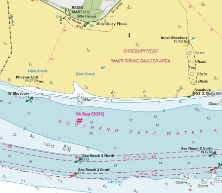
%2024.jpg)
 Fl(5)Y.20s and
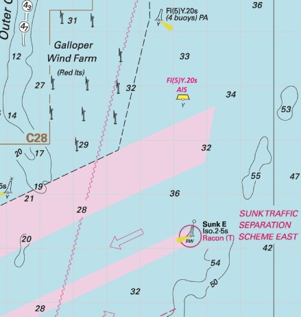
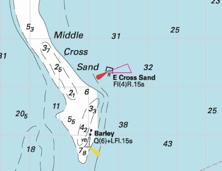


%2024.jpg)
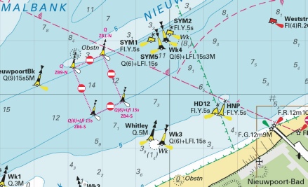
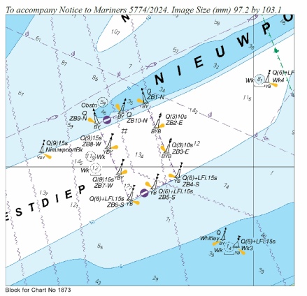
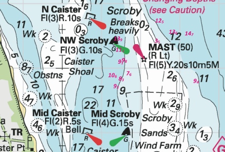
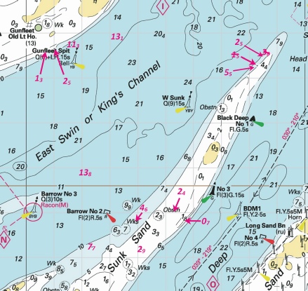
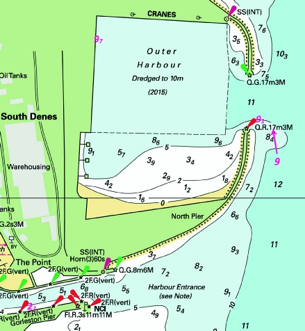
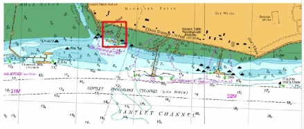
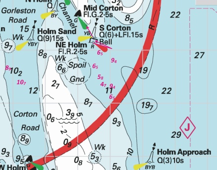
 at 51° 45´·67N., 1° 10´·95E. and delete
  , close S.
 at 51° 44´·90N., 1° 15´·56E.
 at 51° 45´·51N., 1° 17´·64E.
 at 51° 45´·60N., 1° 18´·33E.
 at 51° 50´·03N., 1° 25´·19E.
 at 51° 53´·91N., 1° 23´·99E.
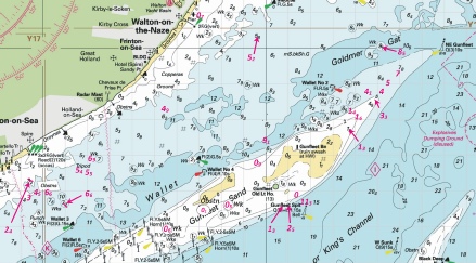
 Q(3)10s HBE
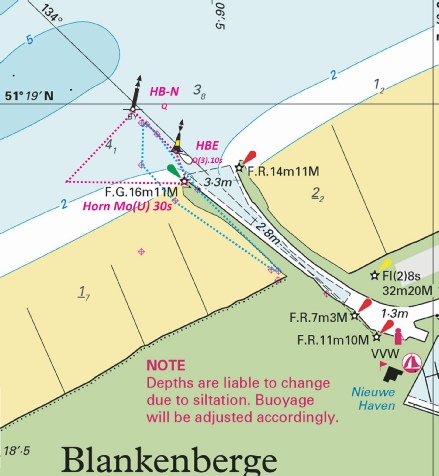
 at:
at: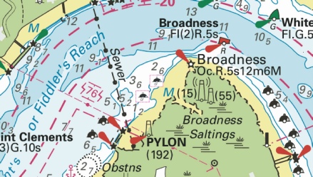
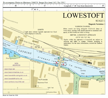
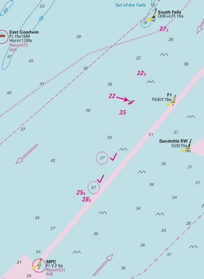
 at 51° 25´·753N., 0° 43´·409E.
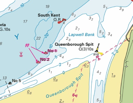
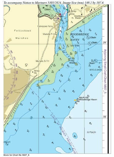

 at 51° 24´·09N., 1° 21´·95E.
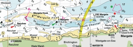
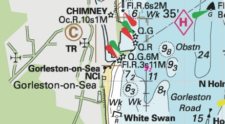
 Q(3)10s HBE
  Q HB-
Q HB-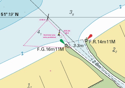
 at 51° 57´·545N., 1° 16´·725E.
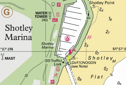
%2024.jpg)
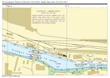
 at 51° 28´·02N., 0° 46´·74E.
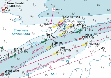
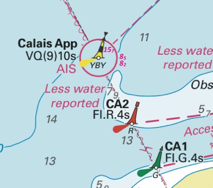
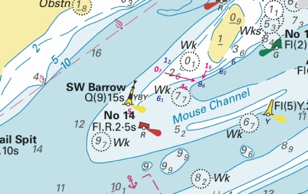
 at 51° 02´·28N., 1° 46´·40E.
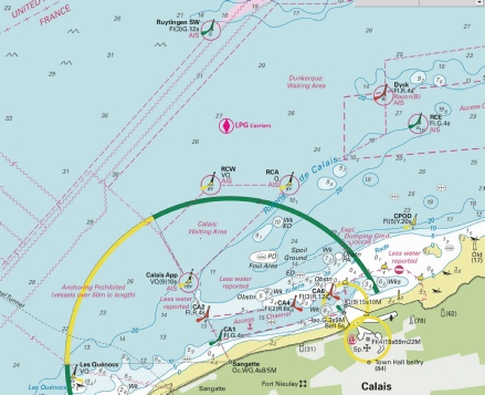
%2024.jpg)
 Fl(2)G.5s SW Holm
  VQ(6)+LFl.10s S Holm
 Q.R Newcome Sand
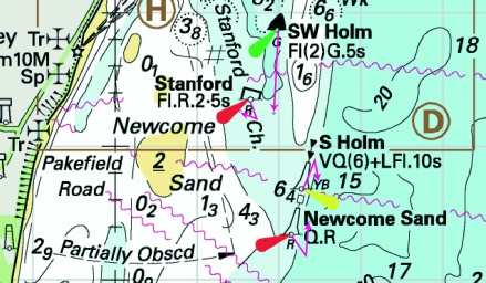
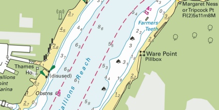
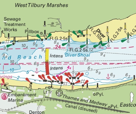
 Fl.Y.2s B
  Fl.Y.2s B, close NE above
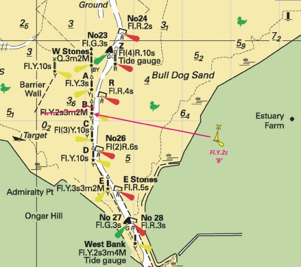
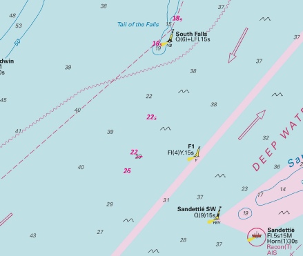
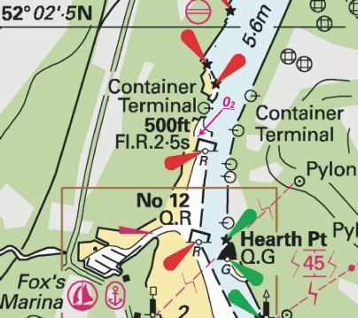
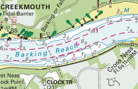
%2024.jpg)
%2024.jpg)
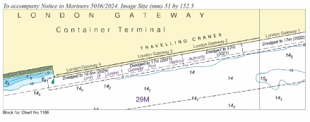
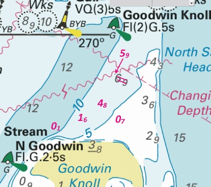
%2024.jpg)
%2024.jpg)
%2024.jpg)
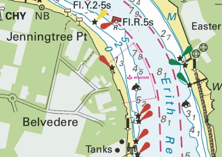
%2024.jpg)
%2024.jpg)
 at 51° 37´·77N., 1° 35´·43E.
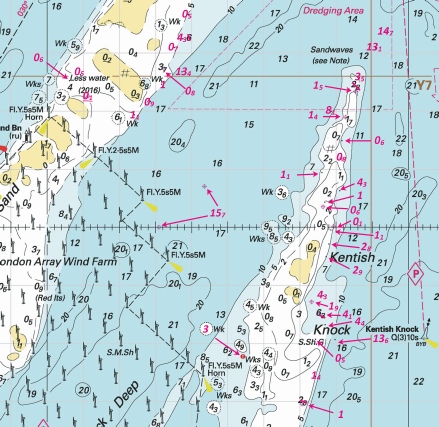
%2024.jpg)
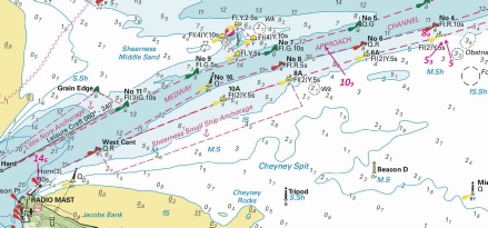
%2024.jpg)
%2024.jpg)
 with
with  at 51° 29´·74N., 0° 44´·02E.
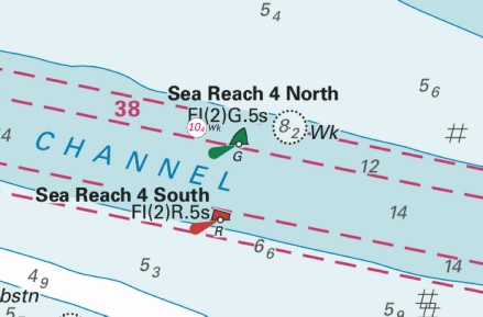
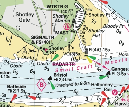
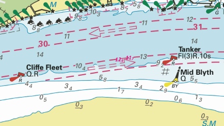
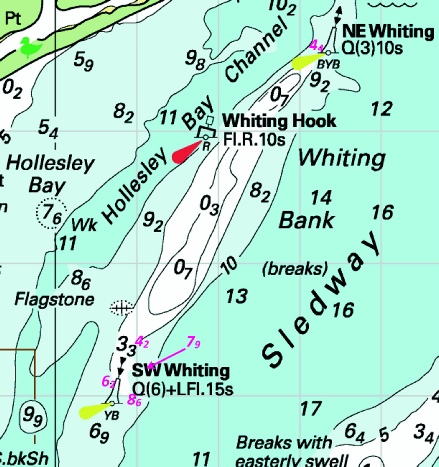

%2024.jpg)
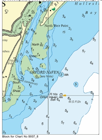
%2024.jpg)
%2024.jpg)
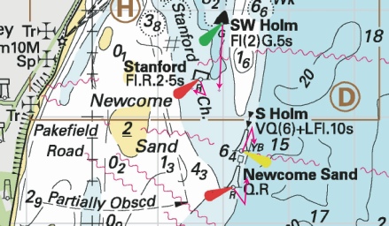

 at 51° 23´·15N., 2° 28´·45E.
 at 51° 22´·53N., 1° 03´·91E. Delete former
  close SE of above.
 joining:
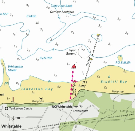
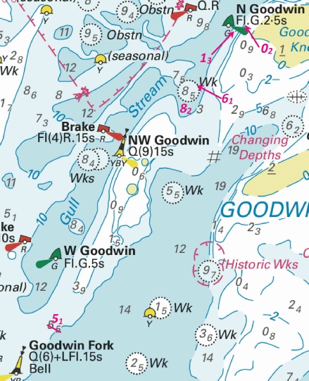
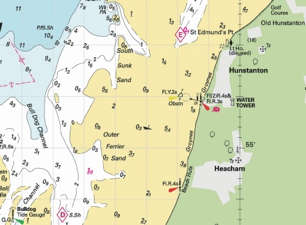
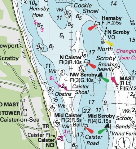
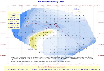
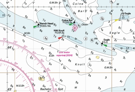
 , joining:
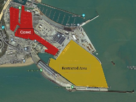
%2024.jpg)
 Fl.G.5s
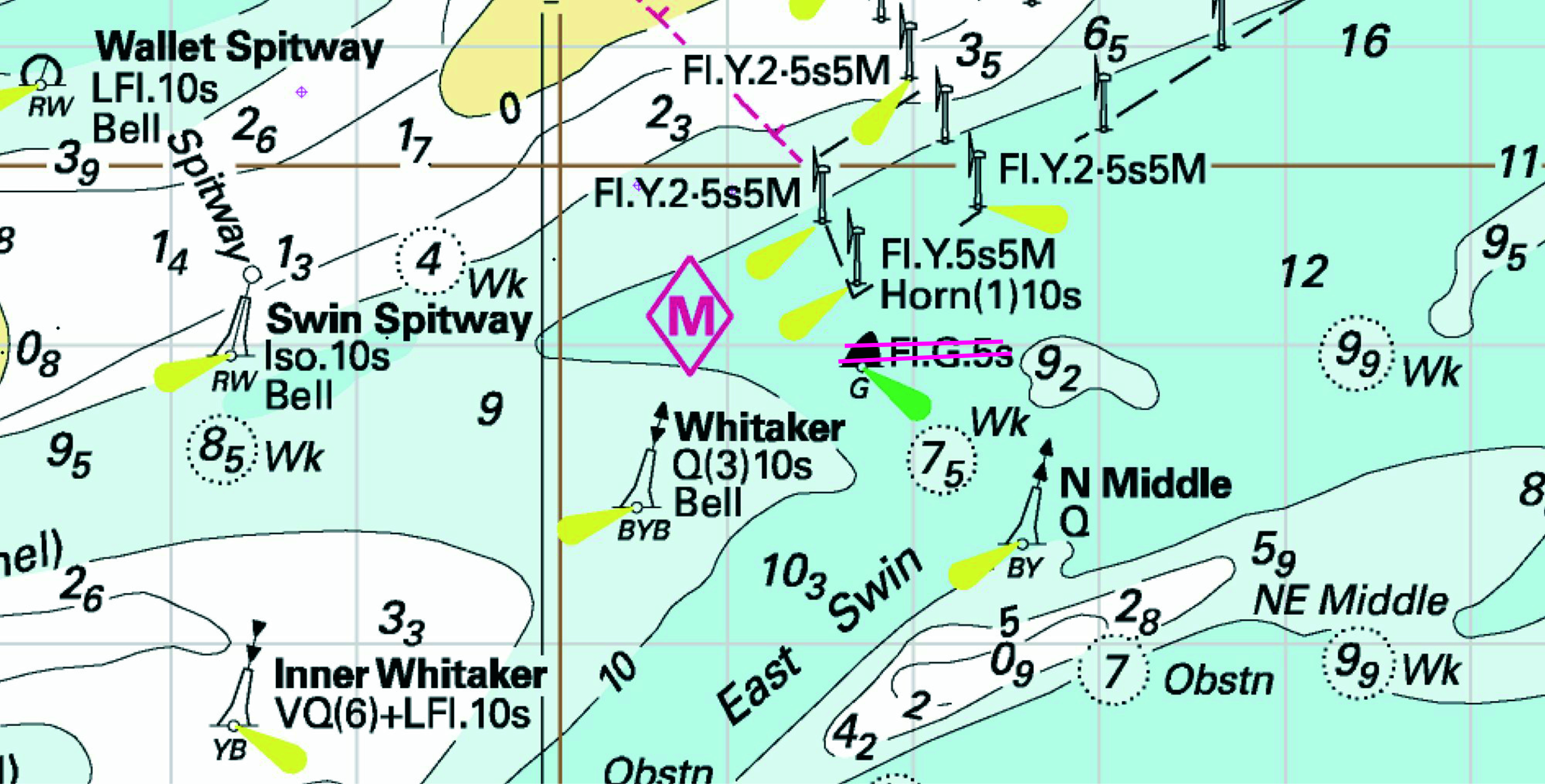

 Q(6)+LFl.15s S Corton Bell
 Fl.R.2·5s NE Holm
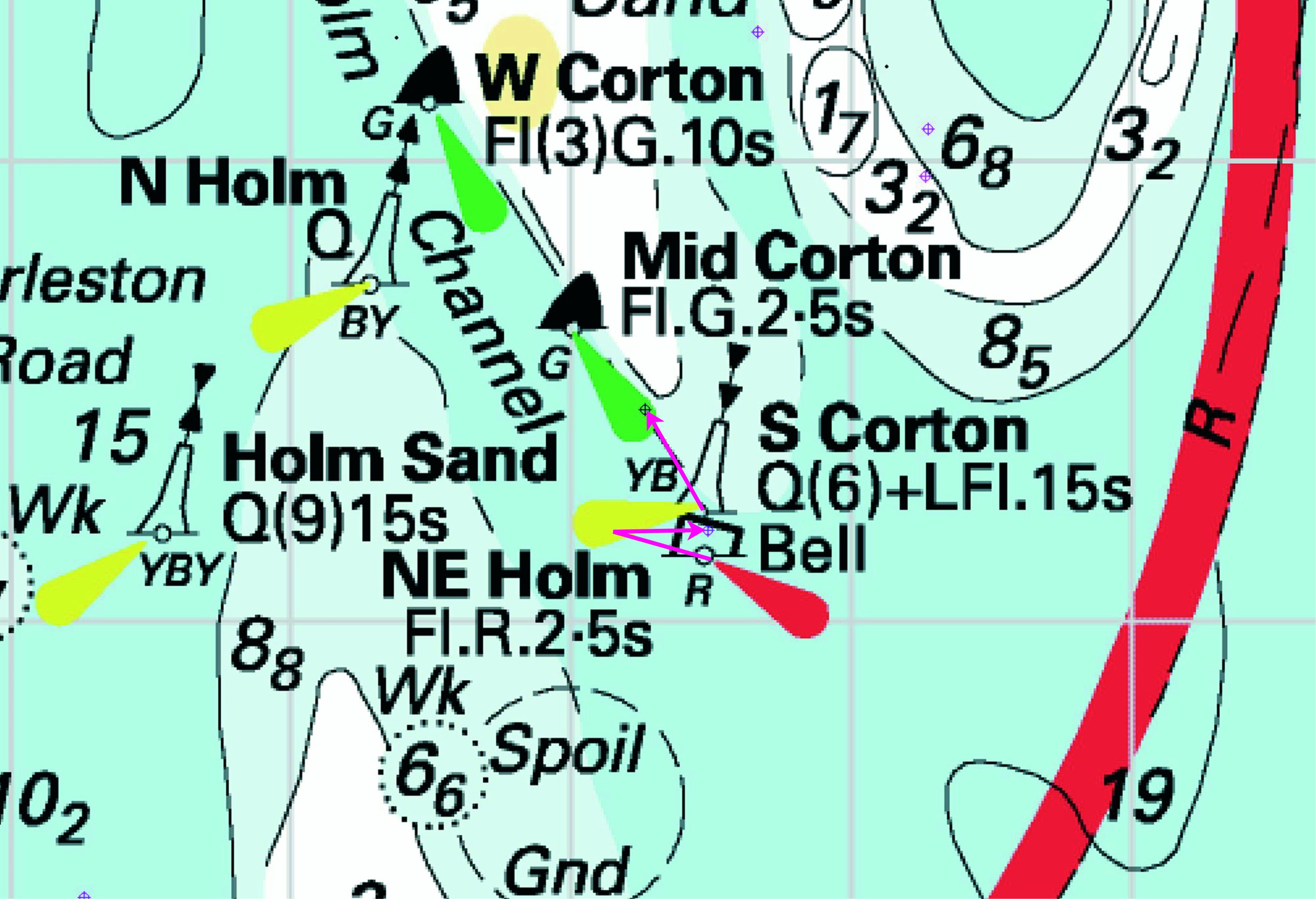
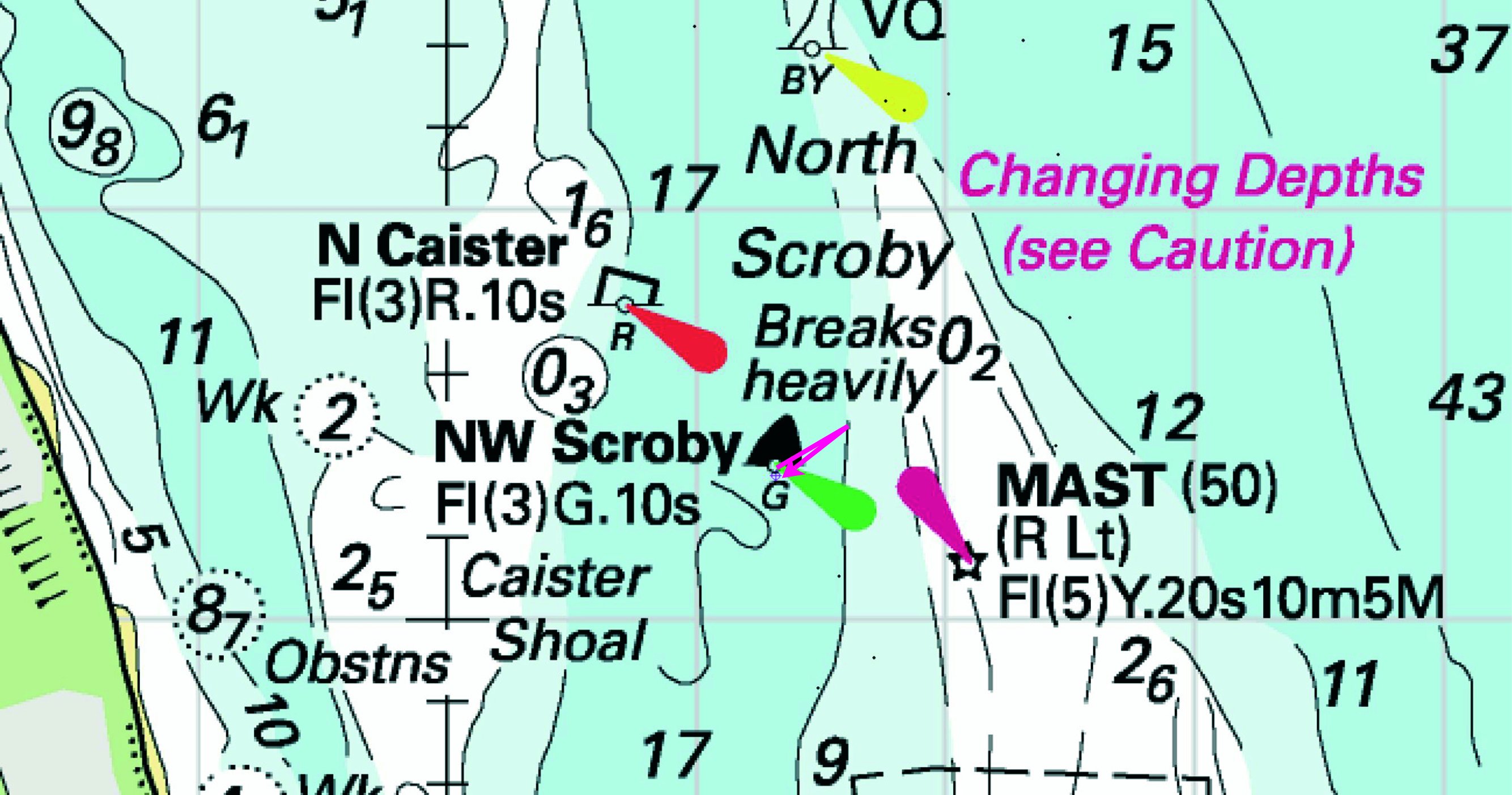
 Q ELI-
 VQ(3)5s ELI-
 Q(9)15s ELI-
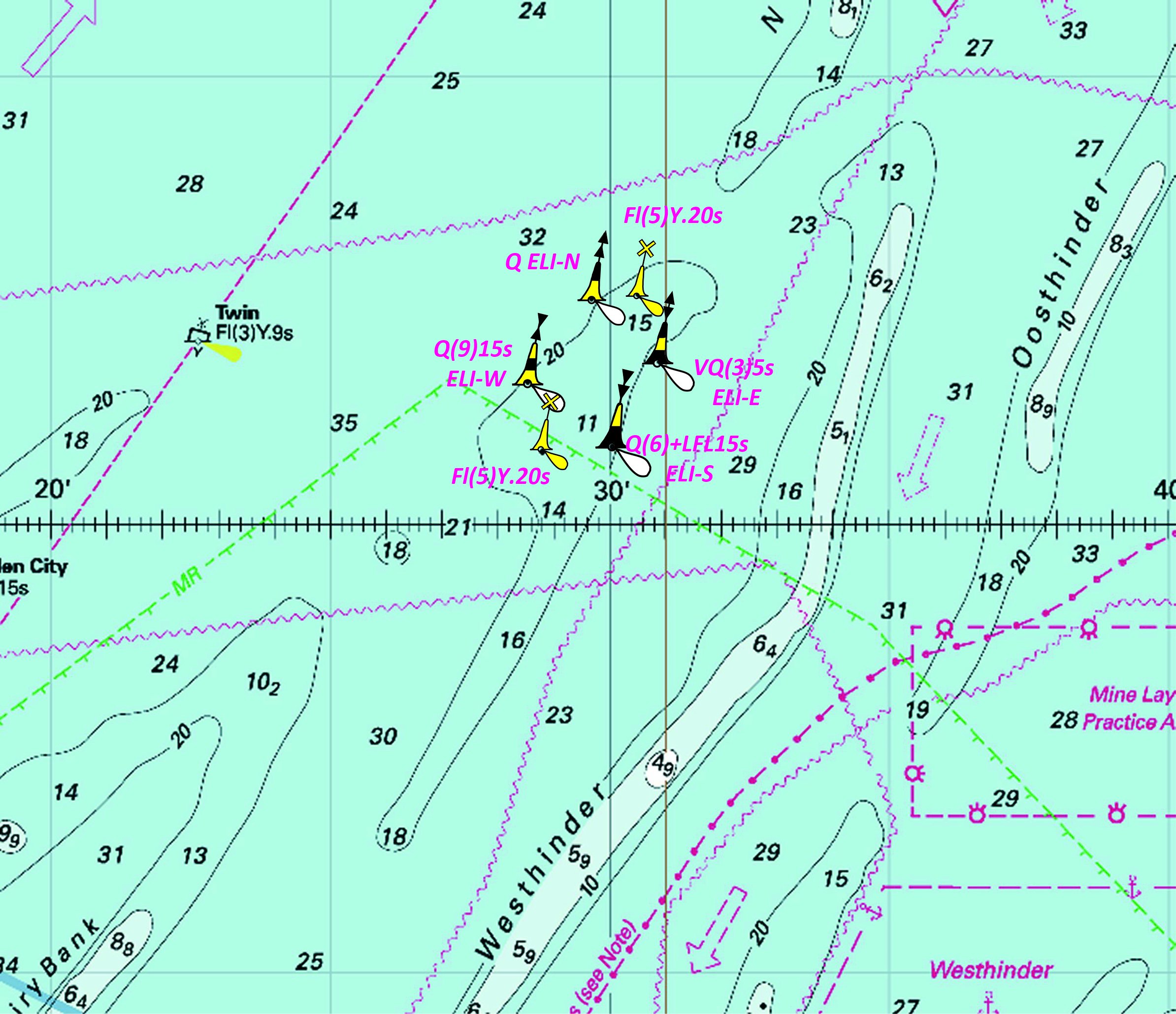
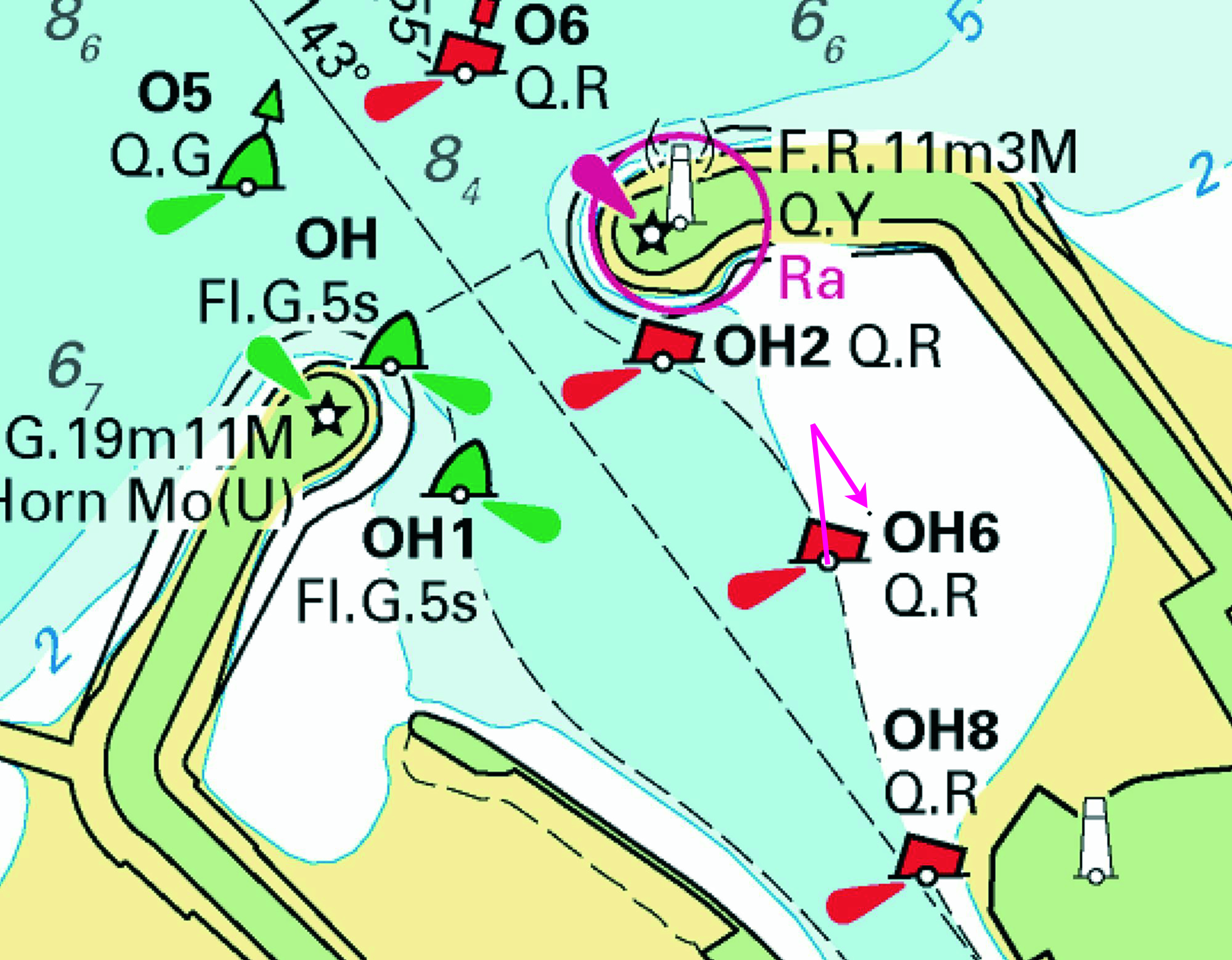
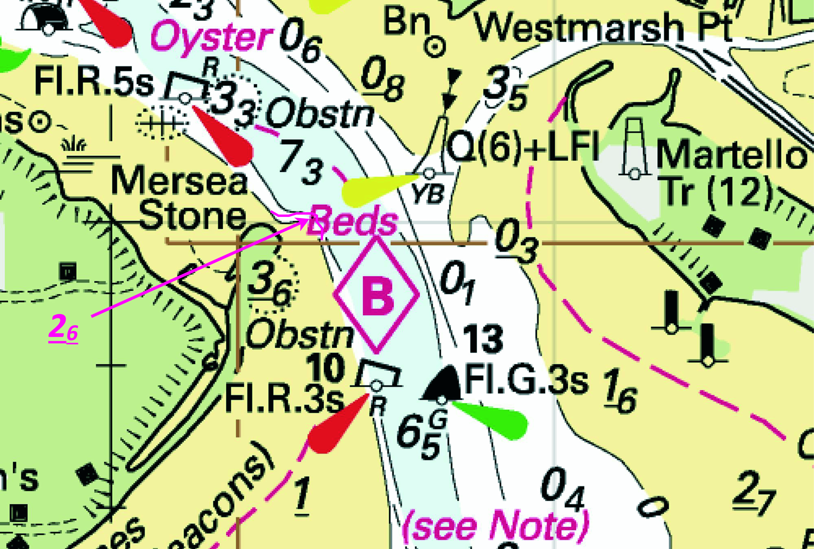


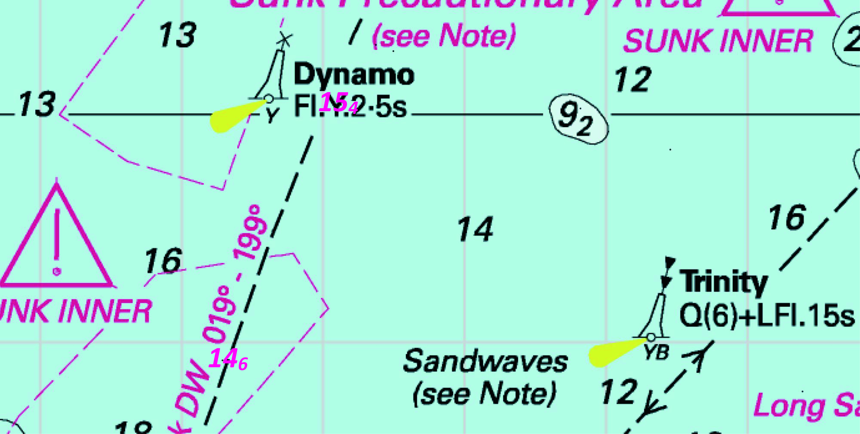
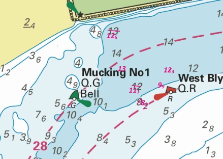
%2024.jpg)
%2024.jpg)

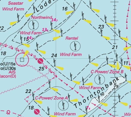
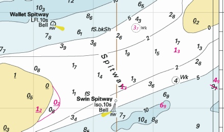
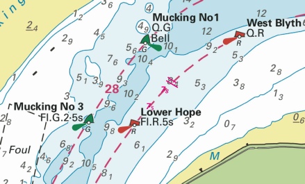
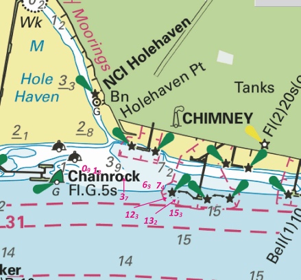
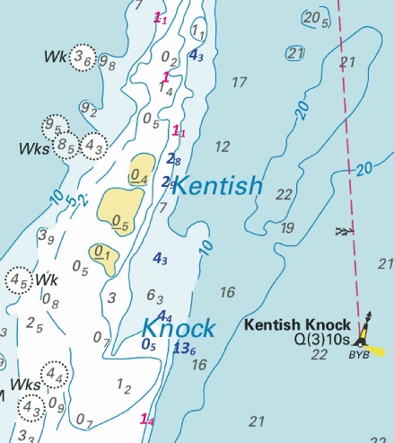
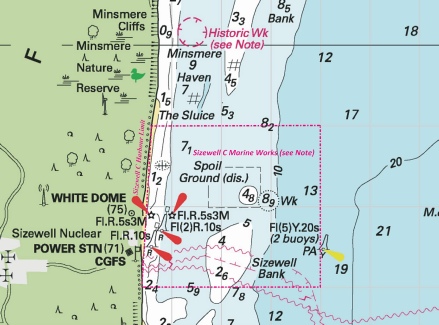
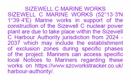
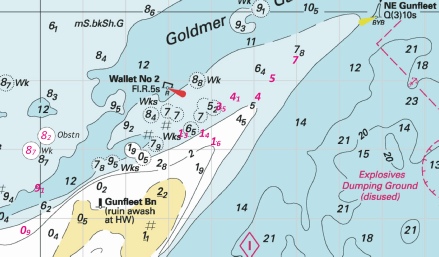
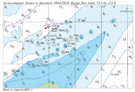
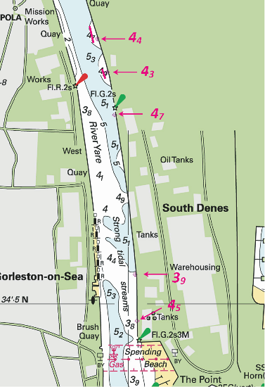
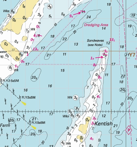
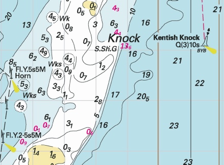
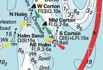
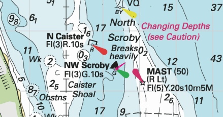
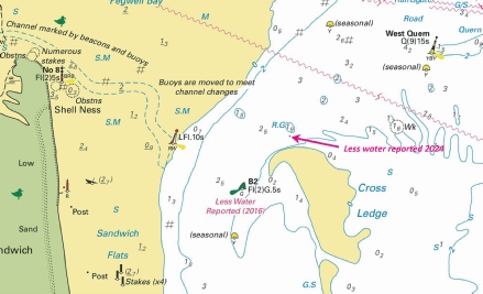
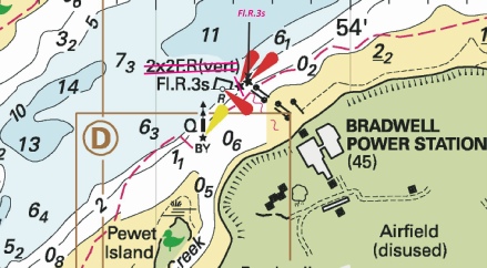
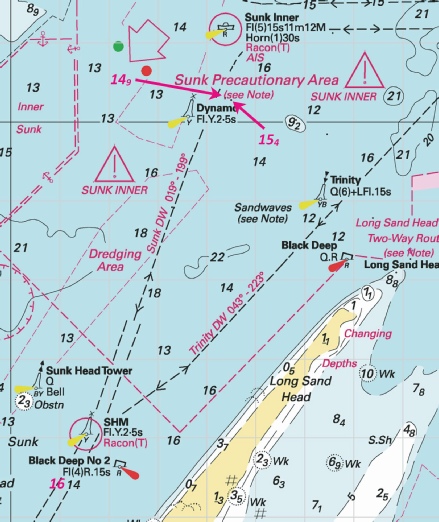
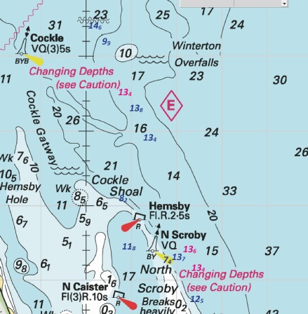
 F.R.11m10M with symbol, red, white and red unlit beacon with X-
 Q HB-
Q HB- (2 beacons) at
  , close NW of:
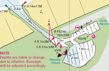
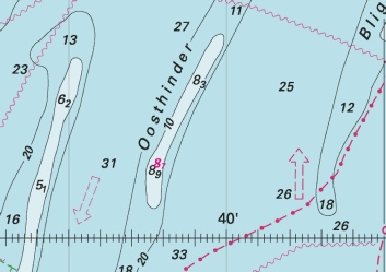
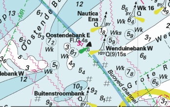
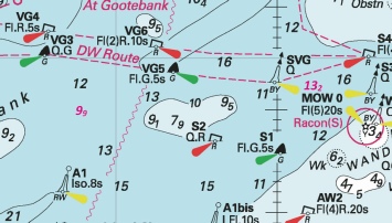
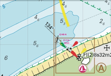
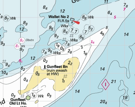
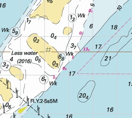
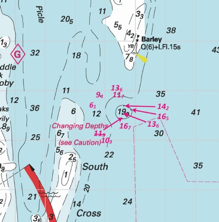


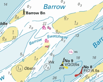
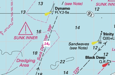
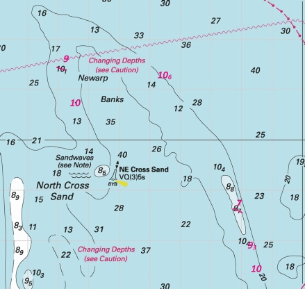
 F.R at 51° 21´·41N., 3° 11´·01E.
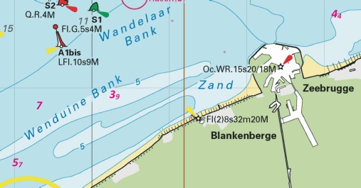
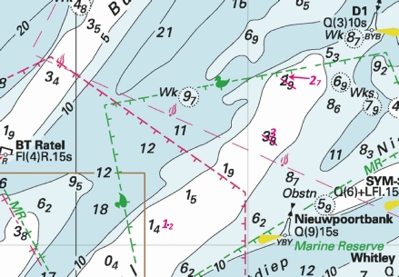
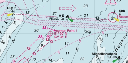
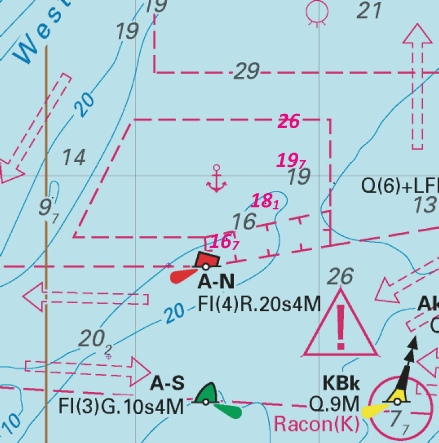
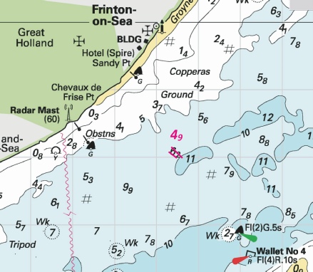
%2024.jpg)
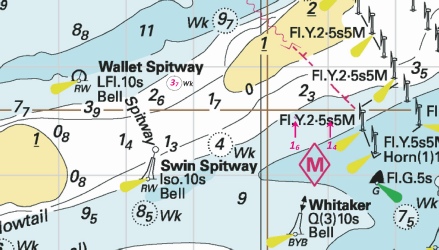
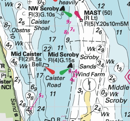
%2024.jpg)
 VQ Long Sand Head
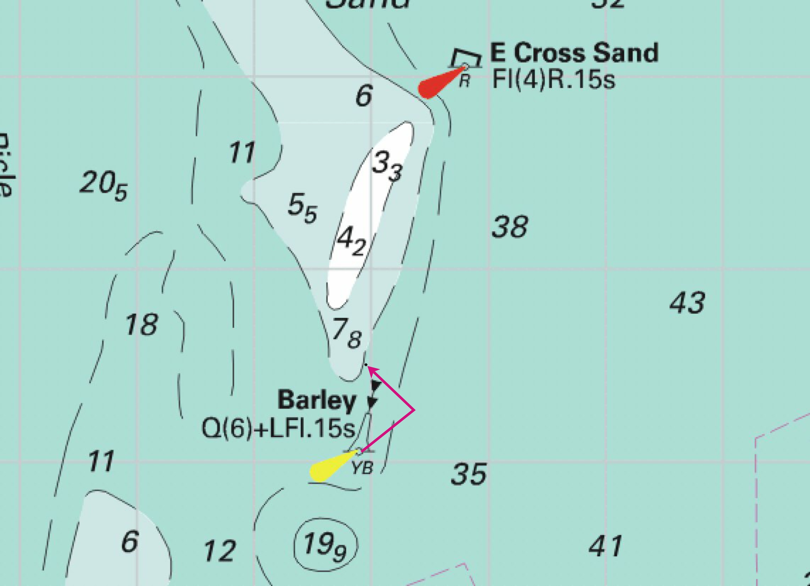
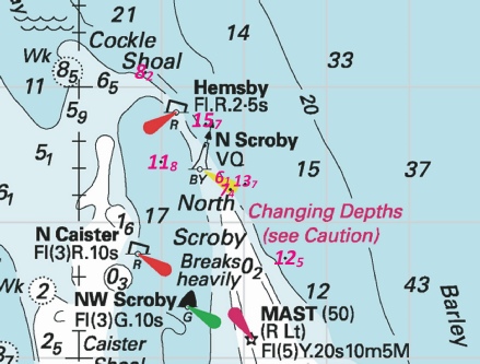
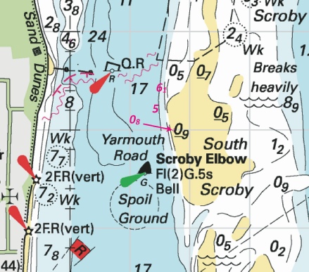
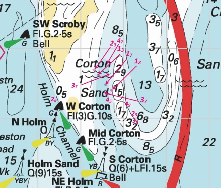
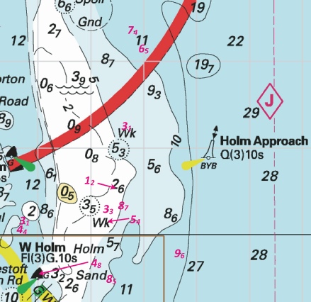
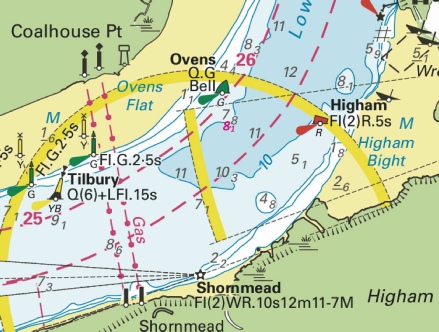
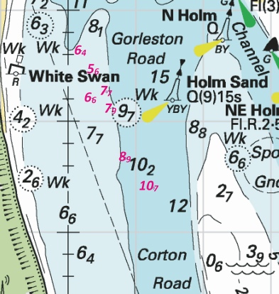
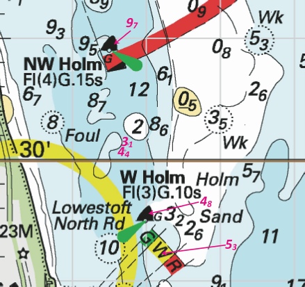
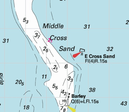
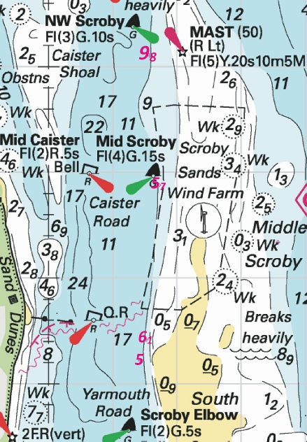
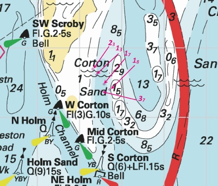
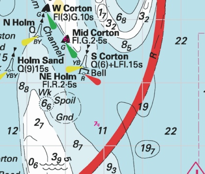
 at 51° 37´·29N., 0° 50´·51E.

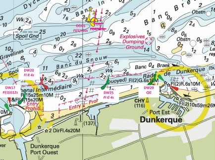

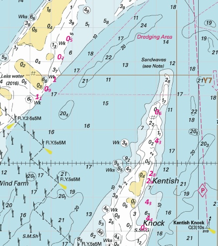
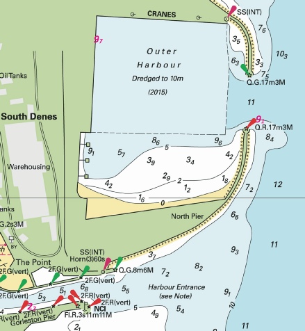
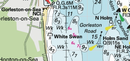
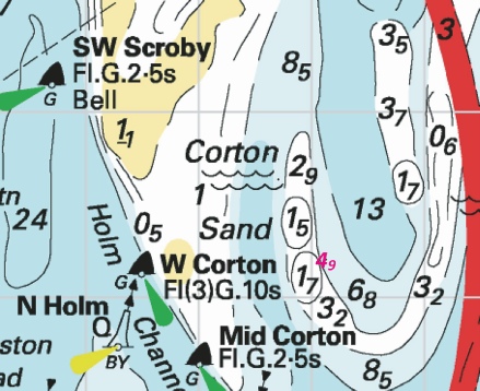
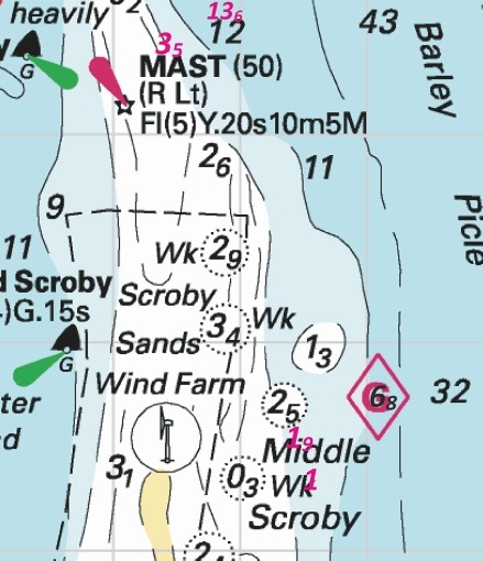
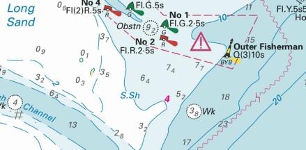
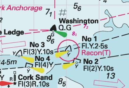
 Wk
Wk 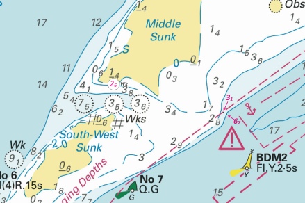

 at 51° 29´·73N., 0° 44´·39E.
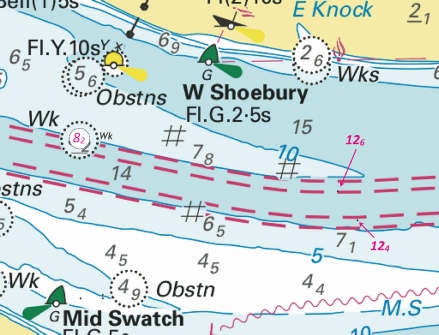
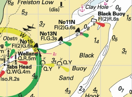
 Fl.Y.5s HD15
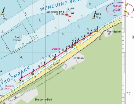
%2024.jpg)

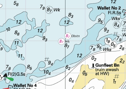
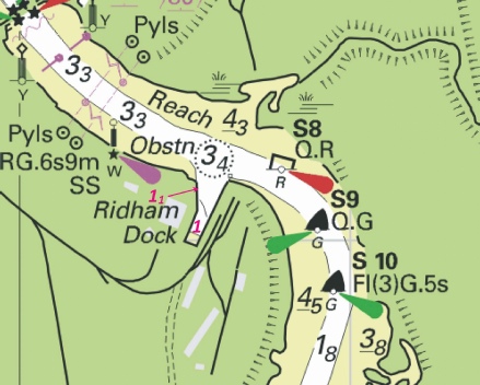
%2024.jpg)
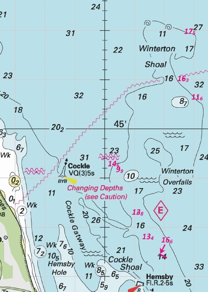
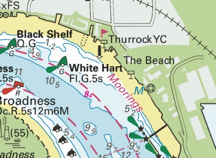
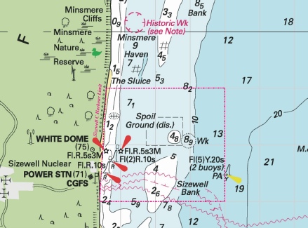


 , within:
  Fl.Y.5s
 at 53° 01´·61N., 0° 58´·27E.


 at:
at: Fl(5)Y.20s
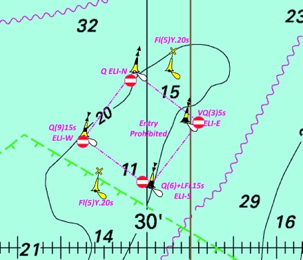
.jpg)
.jpg)


 entry prohibited, within:
 SG 16
SG 16 
 SG 15
SG 15 

 Q ELI-
 VQ(3)5s ELI-
 Q(6)+LFl.15s ELI-
 Q(9)15s ELI-
 Obstn
Obstn 

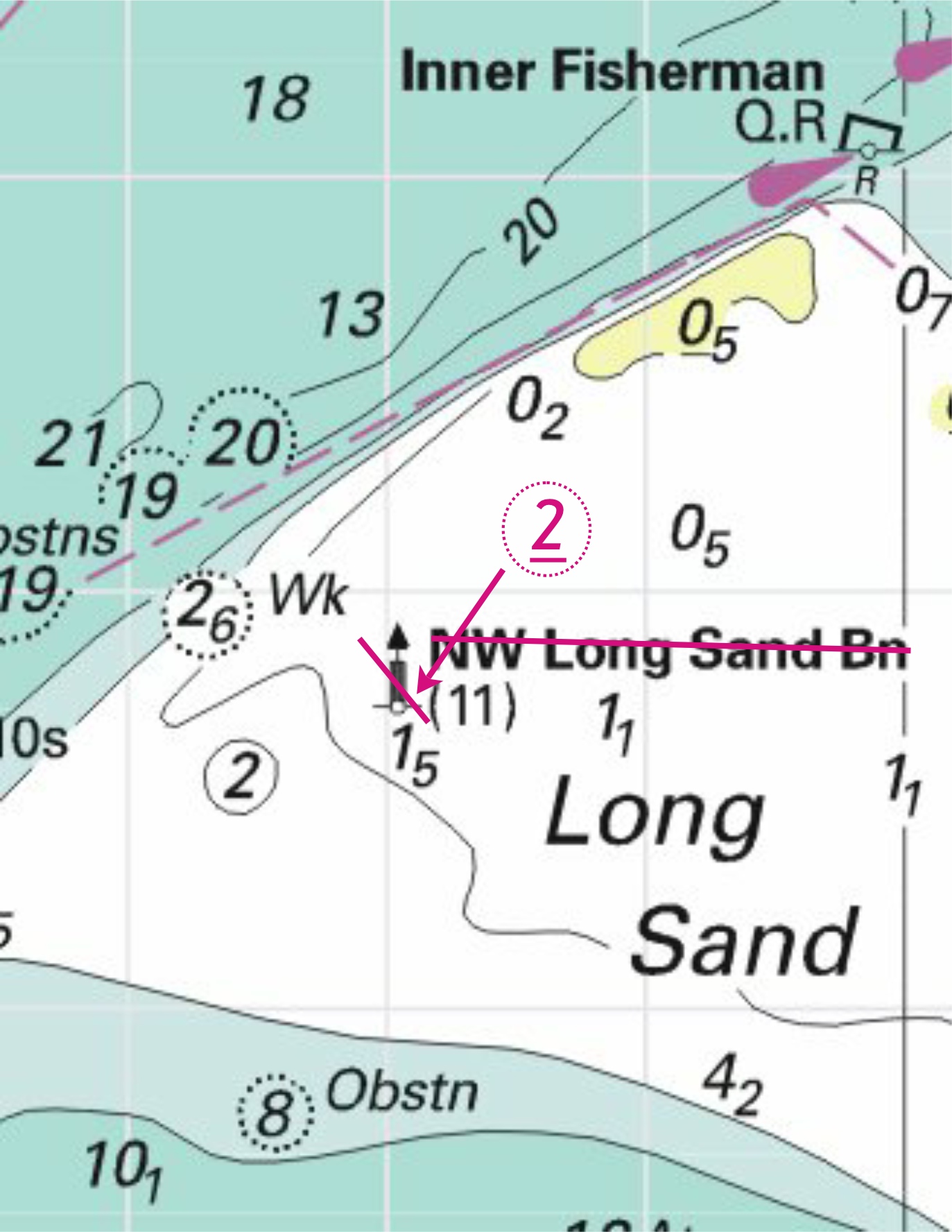


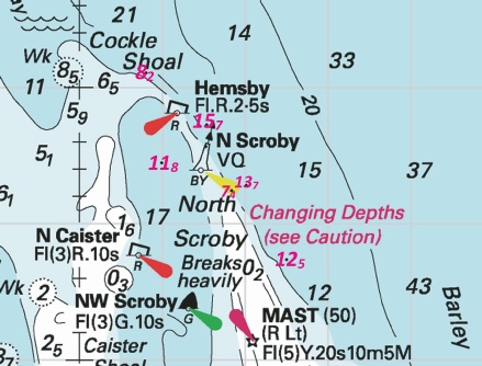
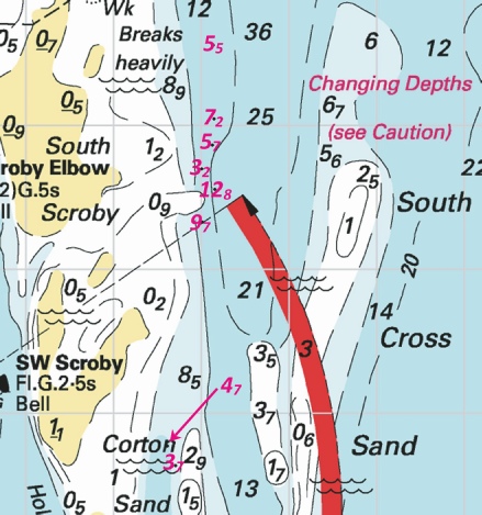


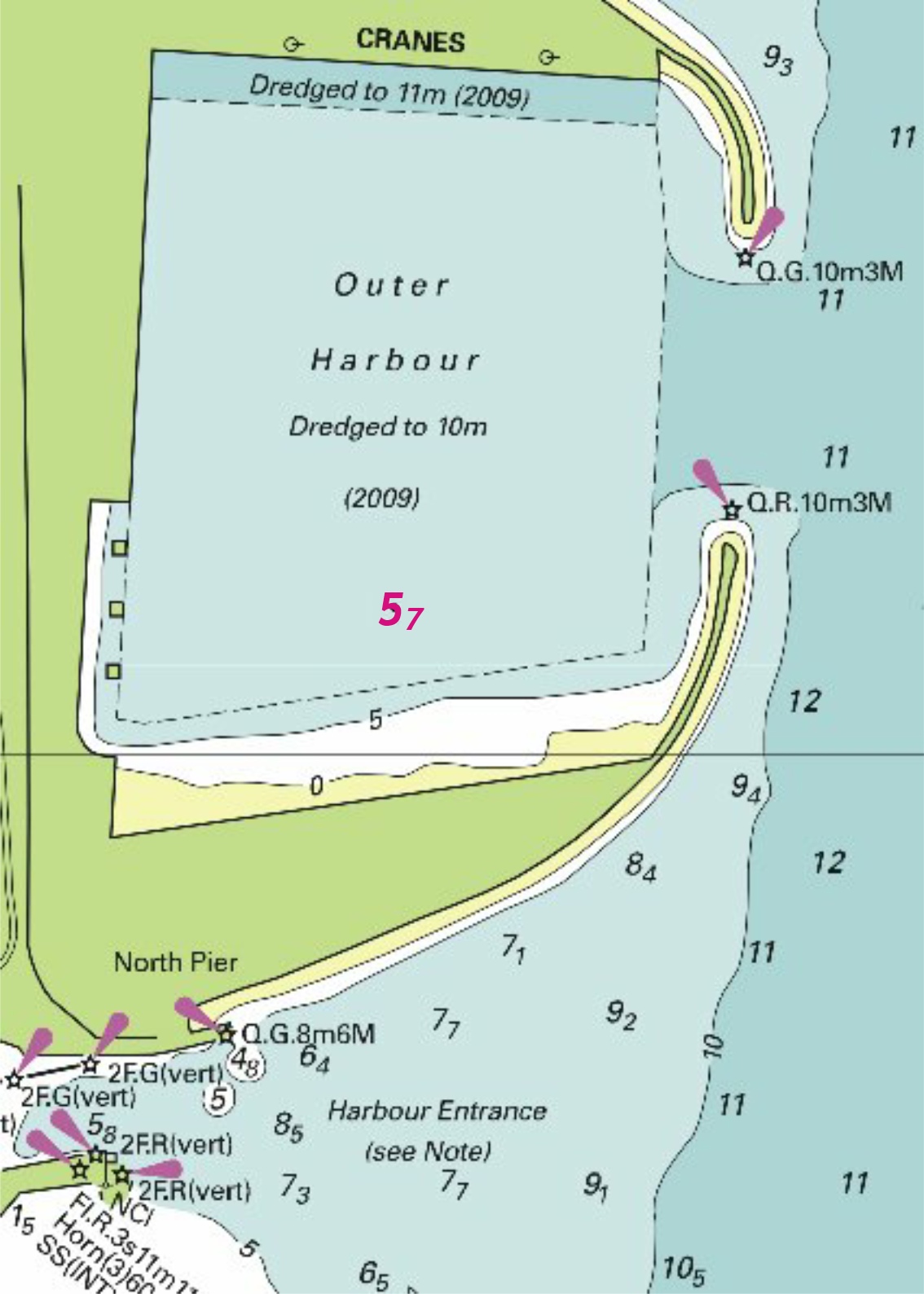


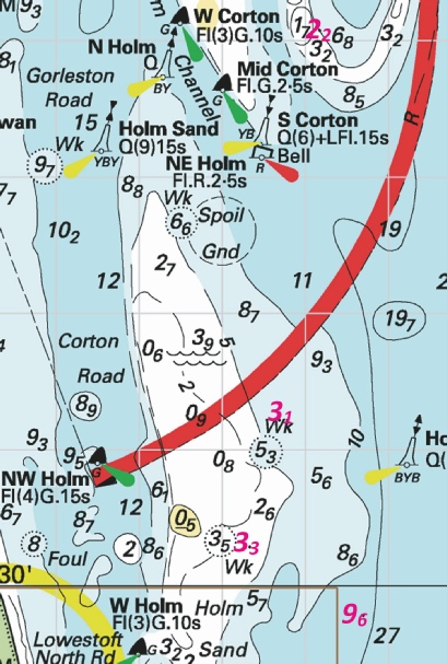


.jpg)

 Fl.Y.5s3M
 Fl.Y.5s3M, close NE of
 Fl.Y.2·5s3M, close NE of 52° 27´·72N., 1° 45´·82E.
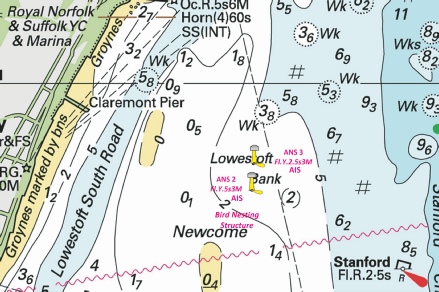
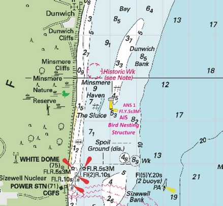

 Iso.R.4s SG 6 at 51
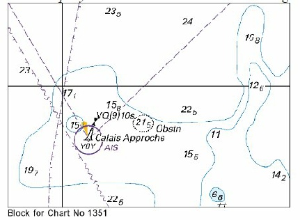

 VQ N Scroby
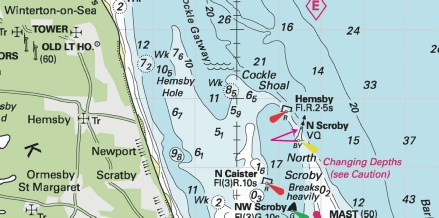


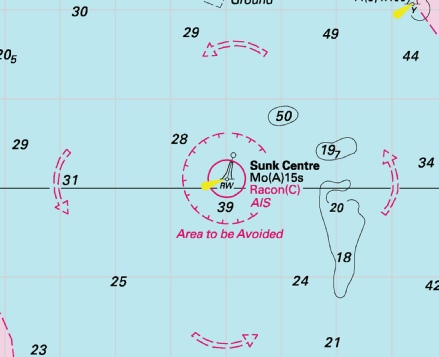
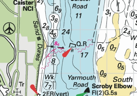

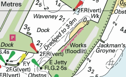
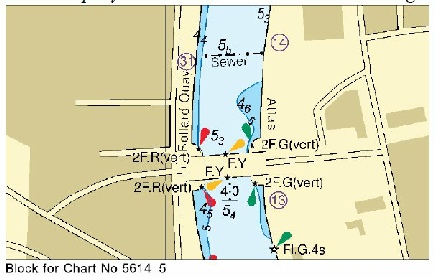

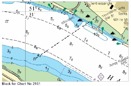
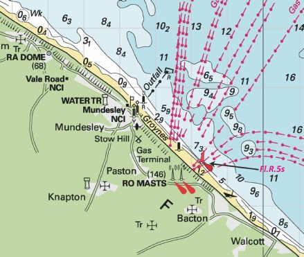
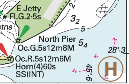

.jpg)
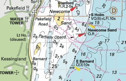

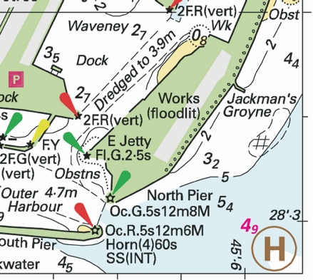


 with depth,
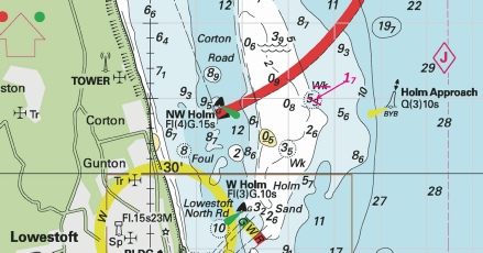
 Raysand North
  Raysand
  Raysand Middle
  Raysand North
 at 51° 23´·622N., 0° 30´·265E. and

.jpg)
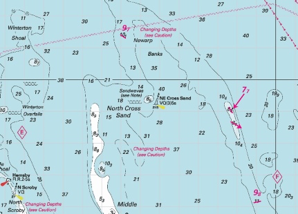
 Obstn
Obstn 


 at 51° 22´·23N., 2° 29´·55E.


 at 51° 24´·42N., 2° 49´·09E.
 with
with  at 51° 22´·70N., 3° 05´·24E.
 ,
,  ,
, 


 at 51° 22´·16N., 2° 26´·23E.
 at 51° 22´·55N., 2° 29´·25E.
 at 51° 23´·47N., 2° 35´·90E.


 at 51° 11´·94N., 2° 44´·97E.
 at 51° 14´·78N., 2° 55´·39E.
 at 51° 24´·74N., 3° 06´·58E.


 at 51° 22´·72N., 3° 05´·20E.


 Fl(5)Y.20s
.jpg)


.jpg)
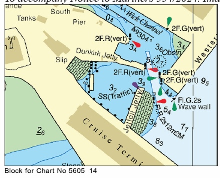
.jpg)
 Fl.Y.2s B
  Fl.Y.2s B at 52° 49´·09N., 0° 21´·14E.
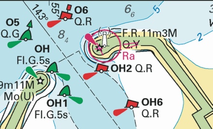
 at 51° 31´·92N., 1° 02´·86E.
 (3 buoys)
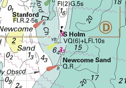

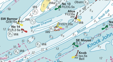
 at 51° 27´·496N., 0° 16´·031E.
 with
with  at 50° 48´·11N., 1° 19´·95E.


 Q Obstn23
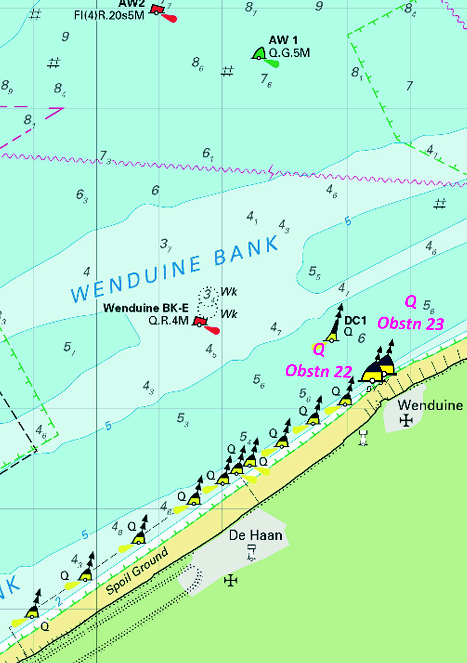

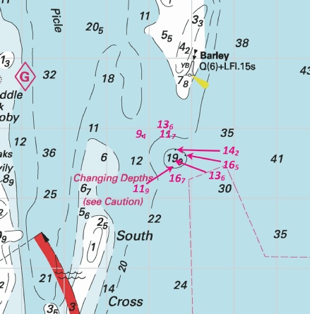

 at 51° 35´·54N., 3° 07´·96E.
