|
Notices - |
||
|
Week 17 |
ENGLAND - Replace:
Notice 1764 refers Base image is from Imray chart IN5043 by courtesy of Imray and Meridian Chartware.
|
Affects: UKHO SNC: 1183, 1606 and 1607. UKHO SCC: 5606.2. Imray Full Charts: C1 Imray Leisure Charts: 2100.1 Revised depth in the centre of the North Edinburgh Channel: now swept at 6.5m so unlikely to hinder leisure craft’s progress. But of course the North Edinburgh Channel has no buoyage.
|
|
Week 13 |
ENGLAND - Submarine cable laying works are taking place between East Anglia Three Offshore Wind Farm and a site NE of Felixstowe, along a line joining the following positions: 52° 00´·02N., 1° 25´·40E. 51° 59´·62N., 1° 26´·45E. 52° 00´·39N., 1° 31´·01E. 52° 04´·18N., 1° 37´·24E. 52° 05´·33N., 1° 43´·47E. 52° 07´·88N., 1° 49´·56E. 52° 13´·38N., 2° 18´·29E. 52° 13´·70N., 2° 26´·10E. 52° 17´·77N., 2° 26´·96E. 52° 20´·82N., 2° 30´·40E. 52° 20´·88N., 2° 34´·48E. 52° 27´·14N., 2° 35´·84E. 52° 27´·62N., 2° 44´·99E. 52° 38´·93N., 2° 45´·08E. 52° 40´·24N., 2° 51´·74E. Charts will be updated when works are complete. Mariners are advised to navigate with caution in the area. Notice 1353(P) refers Base image is from UKHO SN chart 1408. © Crown Copyright and/or database rights. Reproduced by permission of The Keeper of Public Records and the UK Hydrographic Office (www.GOV.uk/UKHO).
|
Affects: UKHO SNC: 1406, 1408, 1504, 1543, 1610, 1630, 1631, 2052, 2182A and 2693. UKHO SCC: 5607.5, 5614.1 and 5614.25. Imray Full Charts: C30 Imray Leisure Folios: 2110.2 This preliminary notice advertises the route for the power cable out from just NE of the Deben to the East Anglia Three Offshore Wind Farm. This is associated with the following preliminary notice of the marking of the Wind Farm perimeter. The Image illustrates the route and the location and general marking of the Wind Farm. The following notice shows the detail and characteristics of WF marking.
|
|
Week 13 |
ENGLAND - *Construction of the East Anglia Three Offshore Wind Farm is taking place in the vicinity of position 52° 40´·24N., 2° 51´·74E. The main Wind Farm Array work area is marked by light- Buoy Type Characteristic Position West Cardinal Q(9)15s 52° 31´·81N., 2° 45´·15E. Special Mark Fl.Y.5s 52° 34´·64N., 2° 44´·90E. West Cardinal VQ(9)10s 52° 37´·47N., 2° 44´·87E. Special Mark Fl.Y.5s 52° 40´·30N., 2° 44´·85E. West Cardinal Q(9)15s 52° 43´·12N., 2° 45´·09E. Special Mark Fl.Y.5s 52° 44´·64N., 2° 47´·48E. North Cardinal Q 52° 45´·50N., 2° 50´·96E. Special Mark Fl.Y.5s 52° 45´·71N., 2° 55´·56E. North Cardinal VQ 52° 45´·92N., 3° 00´·15E. East Cardinal Q(3)10s 52° 43´·69N., 3° 00´·75E. Special Mark Fl.Y.5s 52° 40´·79N., 2° 59´·02E. East Cardinal VQ(3)5s 52° 38´·17N., 2° 56´·53E. Special Mark Fl.Y.5s 52° 35´·54N., 2° 54´·04E. East Cardinal Q(3)10s 52° 32´·92N., 2° 51´·56E. South Cardinal VQ(6)+LFl.10s 52° 31´·15N., 2° 48´·25E. All vessels should navigate with caution in the area. A safety zone of 500 metres becomes operational around the turbines under construction. *Former Notice 4802(P)/24 is cancelled. *Indicates new or revised entry Notice 1354(P) refers Base image is from Imray chart C2110.2 by courtesy of Imray and Meridian Chartware.
|
Affects: UKHO SNC: 1504 *These changes will be included in a New Edition of Chart 1504 to be published mid 2025. *Charts 1408, 1631, 2182A and 5614_25 will be updated by Notice to Mariners. This preliminary notice repeats Notice 4802(P) of 2024 which announces the new buoyage marking out the construction area for the East Anglia Three Offshore Wind Farm which will commence later this year. The area is outside of the area which I monitor but I have provided images showing ‘context’ and the buoy ‘map’. While under construction 500m safety zones (aka exclusion zones) will be placed around turbines sites. The power lines are intended to come ashore about 1.4nm north of the Deben at Bawdsey. Subsequent notices will report when the buoys have been placed.
|
|
Week 12 |
ENGLAND - Insert:
51° 29´·01N., 0° 49´·20E. 51° 28´·72N., 0° 44´·63E. 51° 28´·71N., 0° 44´·40E. 51° 30´·11N., 1° 02´·41E. 51° 28´·71N., 0° 56´·60E. 51° 28´·72N., 0° 56´·41E. 51° 28´·80N., 0° 55´·11E.
Notice 1295 refers Base images are from Imray chart IN5037 and 5043 by courtesy of Imray and Meridian Chartware.
|
Affects: UKHO SNC: 1185, 1609 and 3683. Note: Former Notice 2704(T)/24 is cancelled. This update is included in New Edition 1607, published early 2024. UKHO SCC: 5606.7, 5606.9 and 5606.5 Imray Full Charts: C1 Imray Leisure Folios: 2100.2 Last year, following survey work for a new cable laying, unexploded ordnance was discovered – almost a single line of ordnance -
|
|
Week 10 |
New Editions of ADMIRALTY Charts to be published on 20th March, 2025 SN Chart 1607 International Chart Series, England - SN Chart 1975 England - SN Chart 2052 International Chart Series, England - SN Chart 2692 England - |
Charts 1607 and 1975 are important charts for us as these are followd by the echart makers. |
|
Week 8 |
ENGLAND - Insert: depth, 16 at 51° 44´·32N., 1° 30´·29E. Delete depth, 15.8, close SE. depth, 16.7 at 51° 50´·37N., 1° 34´·20E. Delete depth, 17, close S or 16.9 there depth, 16 at 51° 44´·84N., 1° 30´·55E. Delete depth, 15.8, close NE. depth, 15.7 at 51° 49´·02N., 1° 33´·23E. Delete depth, 15.9, close SE. Replace: depth, 15.9, with depth, 16.1 at 51° 45´·87N., 1° 31´·53E. Notice 868 refers Base image is from Imray Chart C1 by courtesy of Imray and Meridian Chartware.
|
Affects: UKHO SNC: 1183, 1975, 2052 and 2692. UKHO SCC: 5607.2 Imray Full Charts: C1 Imray Leisure Folios: 2000.1 Five adjustments of depths on the Black Deep DW channel between the Sunk Inner and the Black Deep No 2. The PLA constantly monitor depths there for the biggest container ships so the depth is never going to hinder use. Note that we need permission from the PLA to be in the Black Deep.
|
|
Week 4 |
ENGLAND - Insert: drying height, 0.2, and extend 0m low water line NE to enclose 51° 47´·82N., 1° 37´·14E. Delete depth, 0.7, close NE and depth, 0.5 or 0.4, close SW. depth, 13.2 at 51° 48´·80N., 1° 35´·99E. Delete depth, 13.7, close NW. drying height, 0.2, and extend 0m low water line NE to enclose 51° 47´·71N., 1° 36´·95E. Delete depth, 0.3, close SW. Replace: depth, 13.3, with depth, 12.8 at 51° 48´·91N., 1° 36´·16E. Notice 349 refers Base image is from Imray chart C1 by courtesy of Imray and Meridian Chartware.
|
Affects: UKHO SNC: 1183, 1610, 1975, 2052 and 2692. UKHO SCC: 5607.2. Imray Full Charts: C1 Imray Leisure Charts: 2100.1 and 2000.1 Two new drying heights on the northeast tail of the Long Sand Head and one reduced depths close by the Trinity south cardinal buoy on the Deep Water channel. It should remain prudent not to cut over the end of the tail of the Long Sand Head as it continues slowly to extend to the northeast.
|
|
SCROLL DOWN FOR 2024 NOTICES |
||
|
Week 52 |
ENGLAND - Insert:
Automatic Identification System, AIS: at light- Notice 5942 refers The base image courtesy of Imray Chart C1 and Meridian Chartware.
|
Affects: UKHO SNC: 1406, 1408, 1610 and 1630. UKHO SCC: 5607.1 Imray Full Charts: C1 A new lit Superbuoy has been placed north of the Sunk E TSS corridor (east of the Galloper Wind Farm). This is within the location of the intended Five Estuaries Offshore Wind Farm.
|
|
Week 50 |
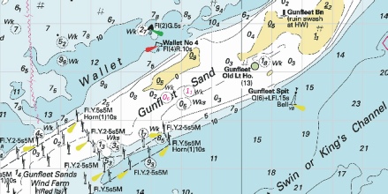
ENGLAND - Note: Former Notice 4414(P)/24 is cancelled. Insert: depth, 13.1 at 51° 46´·38N., 1° 23´·28E. Delete depth, 14.5, close S. depth, 2.5, and extend 5m contour NW to enclose 51° 45´·50N., 1° 28´·50E. Delete depth, 12.1, close NW. depth, 13.8 at 51° 42´·87N., 1° 22´·20E. Delete depth, 14.2, close W. depth, 1.5, enclosed by 2m contour at 51° 45´·27N., 1° 28´·29E. depth, 11.3 at 51° 45´·73N., 1° 21´·63E. Delete depth, 14.4, close SE. depth, 2.5, and extend 5m contour SE to enclose 51° 45´·65N., 1° 21´·01E. Delete depth, 9, close S. depth, 1.3, and extend 2m contour SE to enclose 51° 45´·59N., 1° 20´·72E. Delete depth, 1.4, close NE. depth, 5.5, and extend 10m contour NW to enclose 51° 45´·29N., 1° 28´·19E. Delete depth, 13, close W. Replace: depth, 9.6, with depth, 7.7 at 51° 41´·23N., 1° 22´·36E. Notice 5704 refers The base image courtesy of Imray Chart C1 and Meridian Chartware.
|
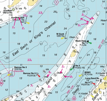
Affects: UKHO SNC: 1183, 1975 and 2692. UKHO SCC: 5607.3, 5607.4 and 5607.2. Imray Full Charts: C1 Imray Leisure Folios 2000.1 This notice confirms Preliminary Notice 4414(P)/24 which reported reduced depths at the Sunk Head and around the Gunfleet Spit SCB. The notice confirms 7 of the reported depths and amends two at the Sunk Head. That suggests cutting across the Sunk Head when you are confident of the height of tide. The image includes three revised depths on the Little Sunk which was reported vide NtM 1026 earlier this year.
|
|
Week 46 |
ENGLAND - Insert depth, 5, and extend 5m contour SW to enclose 51° 32´·03N., 1° 00´·15E. Delete depth, 5.4, close SW. depth, 0.7, and extend 2m contour S to enclose 51° 32´·41N., 1° 01´·45E. Delete depth, 2.7, close SE and depth 1.2 close NE. depth, 1.6, and extend 2m contour S to enclose 51° 32´·44N., 1° 01´·59E. Delete depth, 2.7, close E and depth, 0.1, close NW.
Replace: depth, 5.5, with depth, 4.8, and extend 5m contour S to enclose 51° 32´·34N., 1° 01´·23E. Notice 5252 refers The base image courtesy of Imray Chart IN5043 and Meridian Chartware.
|
Affects: UKHO SNC: 1607 and 1609 UKHO SCC: 5606.6. Imray Full Charts: C1 Imray Leisure Folios 2100.1 This notice reports three reductions of depths close to the SW Barrow west cardinal buoy. We had an earlier Notice this year (1608) in week 15 and this notice amends some of those reductions. The message is that it is not good to cut inside the cardinal buoy to or from the West Swin without due regard.
|
|
Week 42 |
ENGLAND - Insert: depth, 14.7 at 51° 43´·35N., 1° 39´·41E. depth, 1.5, and extend 2m contour NE to enclose 51° 42´·33N., 1° 38´·55E. Delete depth, 1.7, close SW and depth, 1.9, close N. depth, 1.4, and extend 2m contour W to enclose 51° 41´·89N., 1° 38´·27E. Delete depth, 1.7, close SE and depth, 2.9, close SE. depth, 0.8, and extend 2m contour NE to enclose 51° 41´·18N., 1° 38´·16E. Delete depth, 3.5, close SE. depth, 0.1, and extend 2m contour NE to enclose 51° 40´·01N., 1° 37´·94E. Delete depth, 1.1, close SW. depth, 1.9, enclosed by 2m contour at 51° 38´·71N., 1° 37´·33E.
depth, 15.7 at 51° 39´·99N., 1° 33´·10E. Delete depth, 16.8, close NE. depth, 15.7 at 51° 40´·70N., 1° 34´·36E. Delete depth, 16.8, close NW. drying height, 0.1, enclosed by 0m low water line at 51° 42´·25N., 1° 31´·14E. depth, 0.6 at 51° 40´·35N., 1° 37´·65E. Delete depth, 1.4, close SE. Replace: depth, 3.7, with depth, 0.8, enclosed by 2m contour at 51° 42´·72N., 1° 33´·24E. depth, 6.3, with depth, 4.1, enclosed by 5m contour at 51° 38´·51N., 1° 37´·54E. depth, 2.8, with depth, 1, enclosed by 2m contour at 51° 36´·95N., 1° 37´·07E. Notice 4723 refers The base image courtesy of Imray ID10 Chart C1 and Meridian Chartware.
|
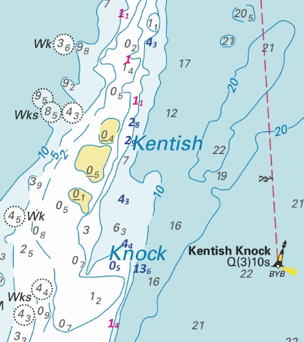
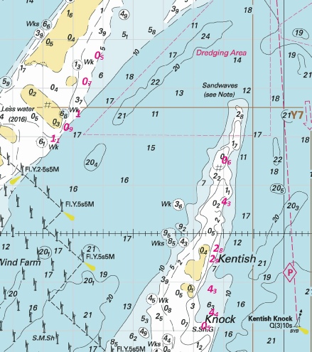
Affects: UKHO SNC: 1183, 1610, 1975 and 2449. UKHO SCC: 5607.2. Imray Full Charts: C1 Imray Leisure Folios 2000.1 Twelve reductions of depth, one new drying height and one new wreck on the Kentish Knock and Long Sand. There have been six previous NtM this year about the Kentish Knock and the Long Sand so the image includes all notifications which amount to 36 reductions of depth. The image is a little ‘busy’! By and large there are no dramatic changes except one little swatch on the Long Sand east of the Wind Farm which appears to be closed by the drying height.
|
|
Week 40 |
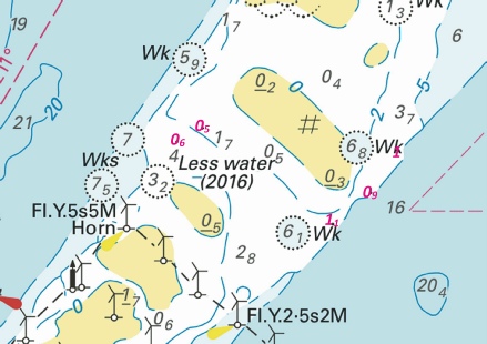
ENGLAND - Depths less than charted exist in the vicinity of Long Sand Head. The most significant are as follows: Depth Position 11·4m 51° 48´·36N., 1° 38´·32E. 11·9m 51° 48´·44N., 1° 37´·86E. 13·7m 51° 48´·39N., 1° 37´·42E. 13·5m 51° 48´·86N., 1° 38´·36E. Mariners are advised to navigate with caution in the area. Charts will be updated when surveying activities are complete. Notice 4551(P) refers The image is copyright of Crossingthethamesestuary.
|
Affects: UKHO SNC: 1975, 2052 and 2692. UKHO SCC: 5607.2 and 5607.4. Imray Full Charts: C1 Imray Leisure Folios 2100.1 and 2000.1 This preliminary notice is prompted by the recent Civil Hydrographic Programme and reports 4 reduced depths at the Long Sand Head two-
|
|
Week 39 |
ENGLAND - Recent survey information has shown that depths less than charted exist within Gunfleet Sands. The most significant are as follows: Depth Position 1·3m 51° 45´·59N., 1° 20´·72E. 2·5m 51° 45´·65N., 1° 21´·01E. 11·3m 51° 45´·73N., 1° 21´·63E. 13·1m 51° 46´·38N., 1° 23´·28E. Recent survey information has shown that depths less than charted exist within Sunk Sand. The most significant are as follows: Depth Position 1·5m 51° 45´·27N., 1° 28´·29E. 3·8m 51° 45´·56N., 1° 28´·60E. 7·7m 51° 41´·23N., 1° 22´·36E. Recent survey information has shown that depths less than charted exist within Kings Channel. The most significant is 13·8m in position 51° 42´·87N., 1° 22´·20E. Mariners are advised to navigate with caution in the area. Charts will be updated when surveying activities are complete. Notice 4414(P) refers The base image courtesy of Imray ID10 Chart C1 and Meridian Chartware.
|
Affects: UKHO SNC: 1183, 1975, and 2692. UKHO SCC: 5607.2 and 5607.4. Imray Full Charts: C1 Imray Leisure Folios 2100.1 and 2000.1 This is a preliminary notice following the recent Civil Hydrology survey reporting reduced depths around the Gunfleet Sands, Sunk Sand and in the Kings Channel. These comprise 1. 4 reductions of depth, 3 adjacent to the Gunfleet Spit cardinal buoy and a fourth with ample water for use north of the cardinal buoy: 2. 2 reductions at the Sunk Head and a third close to the Middle Sunk: 3. A single reduction in the Kings Channel (or West Swin) with ample water for us. There had been a Notice earlier this year (NtM 1026) which advised four reduced depths on the Little Sunk following our survey so those are included in the image. UKHO plan to issue a new edition of SN chart 1975 early next year incorporating all the changes that have been reported this year. That SNC is the leading chart for electronic chartmakers to follow.
|
|
Week 36 |
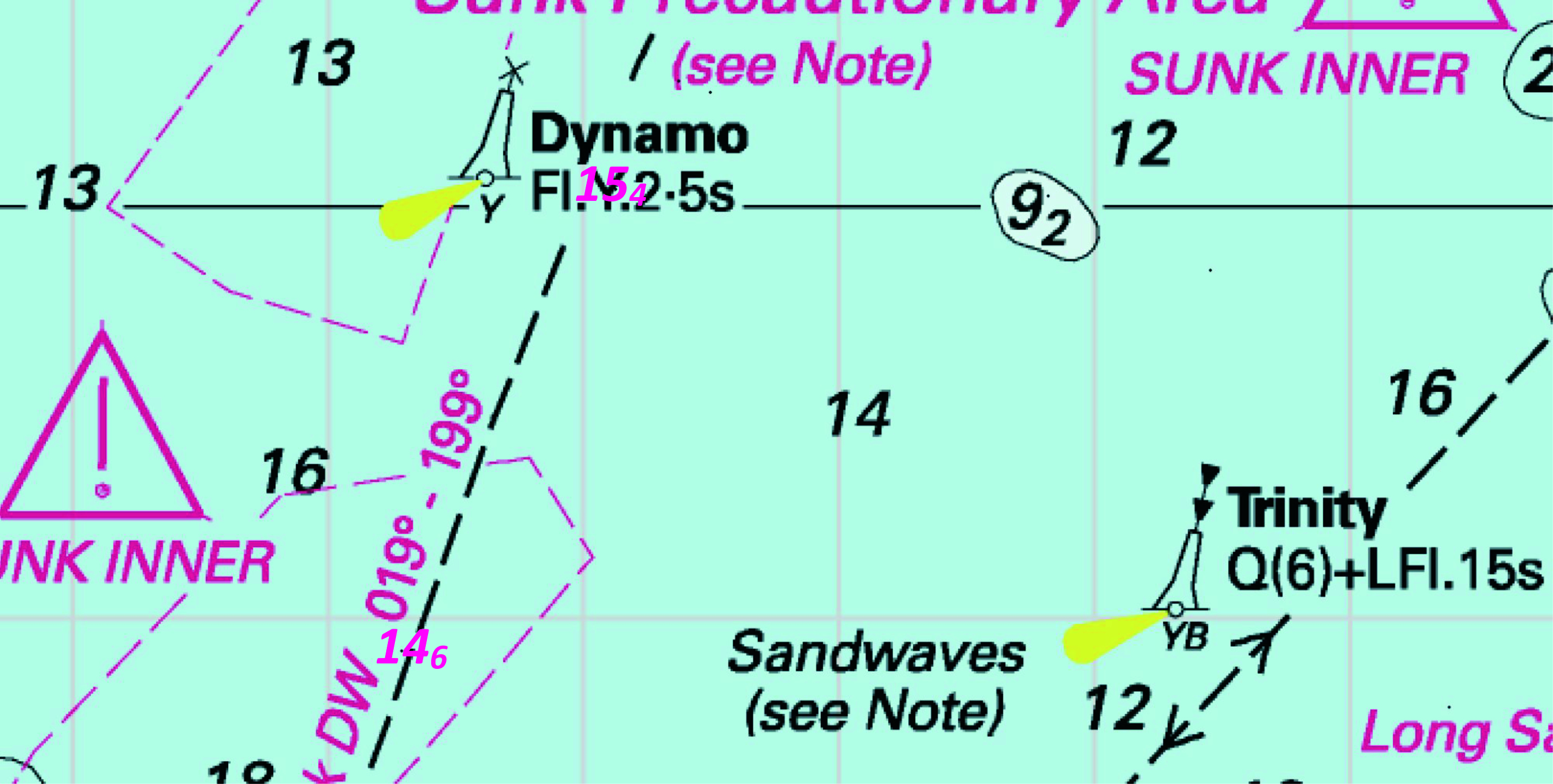
ENGLAND - Replace: depth, 14.8 , with depth, 14.6 at 51° 48´·92N., 1° 33´·29E. depth, 15.9 , with depth, 15.4 at 51° 50´·04N., 1° 34´·13E. Notice 4100 refers The base image courtesy of Imray ID10 Chart C1 and Meridian Chartware.
|
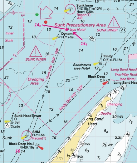
Affects: UKHO SNC: 1183, 1610, 1975 and 2052. UKHO SCC: 5607.2. Imray Full Charts: C1 Imray Leisure Folios 2100.1 This is a regular check on depths on the Black Deep DW channel. Two small reductions of depth between Dynamo and SHM yellow special buoy on the DW line. Unlikely to hinder leisure craft – and don’t hinder there!
|
|
Week 36 |
ENGLAND - Delete
Notice 4032 refers The base image courtesy of Imray ID10 Chart C1 and Meridian Chartware.
|
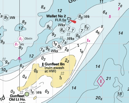
Affects: UKHO SNC: 1183 and 1975. UKHO SCC: 5607.3 and 5607.2. Imray Full Charts: C1 Imray Leisure Folios 2000.1 The SHB marking the SW corner of the Gunfleet Sand Wind Farm has been removed permanently. The buoy was installed many years ago prior to the installation of the two ‘extra large’ demonstration DONG turbines. The turbine are, of course, still there and both are lit.
|
|
Week 34 |
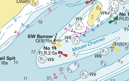
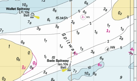
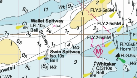
ENGLAND - Insert: drying height, 1.2 at 51° 41´·97N., 1° 07´·10E. Delete drying height, 0.5, close S. drying height, 0.2, and extend 0m low water line E to enclose 51° 42´·05N., 1° 07´·40E. depth, 1.3 at 51° 42´·22N., 1° 08´·49E. Delete depth, 1.5, close NE. depth, 6.9, and extend 10m contour SW to enclose 51° 42´·02N., 1° 09´·17E. Delete depth, 6, close NW. depth, 1.3 at 51° 42´·60N., 1° 09´·40E. Delete depth, 1.8, close N, depth, 1.5, close S and depth, 1.4, close SW (depending on chart). depth, 4.9, and extend 5m contour SE to enclose 51° 42´·28N., 1° 10´·07E. Delete depth, 9.7, close SW. Notice 3917 refers The base image courtesy of Imray ID10 Chart Y17 and Meridian Chartware.
|
Affects: UKHO SNC: 1183 and 1975. UKHO SCC: 5607.3 and 5607.2. Imray Full Charts: C1 and Y17 Imray Leisure Folios 2000.1 This notice provides 6 changes of drying heights and depths at the Spitway as a result of our survey. As we reported, the east edge of the Buxey Sand has extended a little and a little loss of depth in the line twixt the two safe water buoys; the controlled depth there is 1.1m CD close to the Swin Spitway buoy. The image includes the ‘new’ wreck reported by the Civil Hydrology Programme vide NtM 3316/24. I have the issue of the location of the two safe water buoys with Trinity House. Here you can download the new heights and depths and you can also download our chartlet at: https://www.crossingthethamesestuary.com/page29.html
|
|
Week 33 |
ENGLAND - Insert: depth, 1.1, and extend 2m contour NW to enclose 51° 40´·94N., 1° 37´·61E. depth, 1.1, and extend 2m contour E to enclose 51° 39´·95N., 1° 37´·86E. Delete depth, 2.8, close S depth, 1.4, and extend 2m contour SE to enclose 51° 37´·43N., 1° 37´·44E. depth, 1, and extend 2m contour E to enclose 51° 40´·43N., 1° 37´·69E. Notice 3783 refers The base image courtesy of Imray ID10 Chart IN5043 and Meridian Chartware.
|
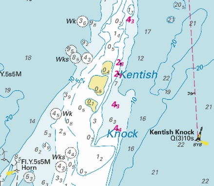
Affects: UKHO SNC: 1183, 1610, 1975 and 2449. UKHO SCC: 5607.2 Imray Full Charts: C1 Imray Leisure Folios 2100.1 and 2000.1 Further reductions of depth on the Kentish Knock. This notice reports 4 reductions whilst others have been reported by Notices 2107, 2796 and 3601. The image shows these reductions of depth in magenta whilst earlier reductions are shown in blue. Crossing the Kentish Knock is NOT recommended!
|
|
Week 33 |
ENGLAND - Insert: depth, 11.5 at 51° 36´·20N., 1° 20´·25E. Delete depth, 12.4, close NE. Notice 3809 refers The base image courtesy of Imray ID10 Chart C1 and Meridian Chartware.
|
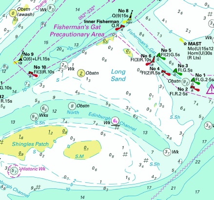
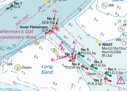
Affects: UKHO SNC: 1606, 1607 and 1975. UKHO SCC: 5606.2 and 5607.2 Imray Full Charts: C1 Imray Leisure Folios 2100.1 and 2000.1 One reduction of depth in the Black Deep right in the middle of the northern entrance of the Fisherman’s Gat but still with ample water for leisure users. In week 12, NtM 1222 announces a reduction of 7 depths in Fisherman Gat. The Image includes all the reductions.
|
|
Week 30 |
ENGLAND - Replace: depth, 15.2 , with depth, 14.9 at 51° 50´·27N., 1° 34´·50E. Insert: depth, 16 at 51° 45´·42N., 1° 30´·98E. Delete depth, 15.6, close S. depth, 15.4 at 51° 50´·30N., 1° 34´·38E. Delete depth, 16.1 , close NW. Notice 3491 refers Base image courtesy of Imray ID10 Chart C1 and Meridian Chartware.
|
Affects: UKHO SNC: 1183, 1975, 2052 and 2692. UKHO SCC: 5607.2. Imray Full Charts: C1 Imray Leisure Folios 2000.1. Continual monitoring of the DW channel from the Sunk into the Black Deep. Three new soundings on the DW line. None likely to hinder leisure craft but don’t linger!
|
|
Week 30 |
ENGLAND - Insert: depth, 5, enclosed by 5m contour at 51° 49´·02N., 1° 25´·44E. Delete depth, 6.8, close SE. depth, 1.6, and extend 2m contour NE to enclose 51° 48´·11N., 1° 24´·13E. Delete depth, 3.5, close E. depth, 9.1, and extend 10m contour SE to enclose 51° 47´·43N., 1° 20´·02E. depth, 7 at 51° 49´·30N., 1° 25´·98E. Delete depth, 8.9, close SE. depth, 13.4, and extend 15m contour SE to enclose 51° 42´·67N., 1° 33´·73E. Notice 3530 refers Base image courtesy of Imray ID10 Chart C1 and Meridian Chartware.
|
Affects: UKHO SNC: 1183, 1975 and 2052. UKHO SCC: 5607.2. Imray Full Charts: C1 Imray Leisure Folios 2000.1. A total of 5 reductions of depth on and around the Gunfleet Sands and on the east side of the Long Sand. 3 are on the north tail of the Gunfleet Sands, one in the Wallet (twixt Nos 2 and 4) and one reduction of depth on the east side of the Long Sand. Two images: the Gunfleet and Wallet image includes an obstruction and a wreck vide NtMs 2019 and 2559. The Long Sand image has a ‘host’ of reductions of depth added vide NtMs 1880 and 2796. Later this year or early next year we can expect a new edition of Chart 1975.
|
|
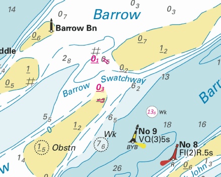
Week 29 |
ENGLAND - Insert drying height, 0.1, enclosed by 0m low water line at 51° 36´·71N., 1° 09´·29E. Delete depth, 05, close E. drying height, 0.3, and extend 0m low water line N to enclose 51° 36´·21N., 1° 09´·45E. Delete drying height, 0.3, close S. Replace: depth, 15.4, with Notice 3363 refers Base image courtesy of Imray ID10 Chart IN5043 and Meridian Chartware.
|
Affects: UKHO SNC: 1183, 1607, 1609 and 1975. UKHO SCC: 5606.6, 5606.2, 5607.3 and 5607.2 Imray Full Charts: C1 Imray Leisure Folios 2000.1, 2100.1. Two new drying heights either side of the Barrow swatchway on the Barrow Sands and a new wreck identified on the north side of the Barrow Deep. At 13.8m over the wreck unlikely to hinder leisure craft.
|
|
Week 29 |
ENGLAND - Insert: depth, 14.8 at 51° 48´·92N., 1° 33´·29E. Delete depth, variously 15.2, 15.4 or 15.7, according to chart close NW. Notice 3414 refers Base image courtesy of Imray ID10 Chart C1 and Meridian Chartware.
|
Affects: UKHO SNC: 1183, 1610, 1975 and 2052. UKHO SCC: 5607.2 Imray Full Charts: C1 Imray Leisure Folios 2000.1 One reductions of depth on the Sunk DW line to and from the Black Deep. This is a regularly check and has, for us, ample water and not where we ought to be.
|
|
Week 28 |
ENGLAND - Insert:
at 51° 42´·84N., 1° 08´·71E. Delete depth, 4, close SE and depth 4 close SW. Replace depth, 8.6, with depth, 1.4, enclosed by 2m contour at 51° 42´·57N., 1° 11´·03E. depth, 5.9, with depth, 1.6, enclosed by 2m contour at 51° 42´·53N., 1° 10´·53E. Notice 3316 refers Base image courtesy of Imray ID10 Chart C1 and Meridian Chartware.
|
Affects: UKHO SNC: 1183 and 1975. UKHO SCC: 5607.3, and 5607.2 Imray Full Charts: C1 Imray Leisure Folios 2000.1 and 2100.1 Two new reductions of depth and one new wreck at the Spitware. These changes are identified by last winter’s Civil Hydrography Programme are additions to my chartlet last week. The wreck has 3.7m water so should not hinder leisure craft. The two new reductions of depth are outside my survey area being close to the west side of the Gunfleet Sands wind Farm.
|
|
Week 27 |
ENGLAND - Insert:
And fog signal, Bell, at the light- Replace:
and Automatic Identification System, AIS, at the light- Notice 3078 refers Base image courtesy of Imray ID10 Chart C1 and Meridian Chartware.
|
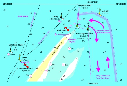
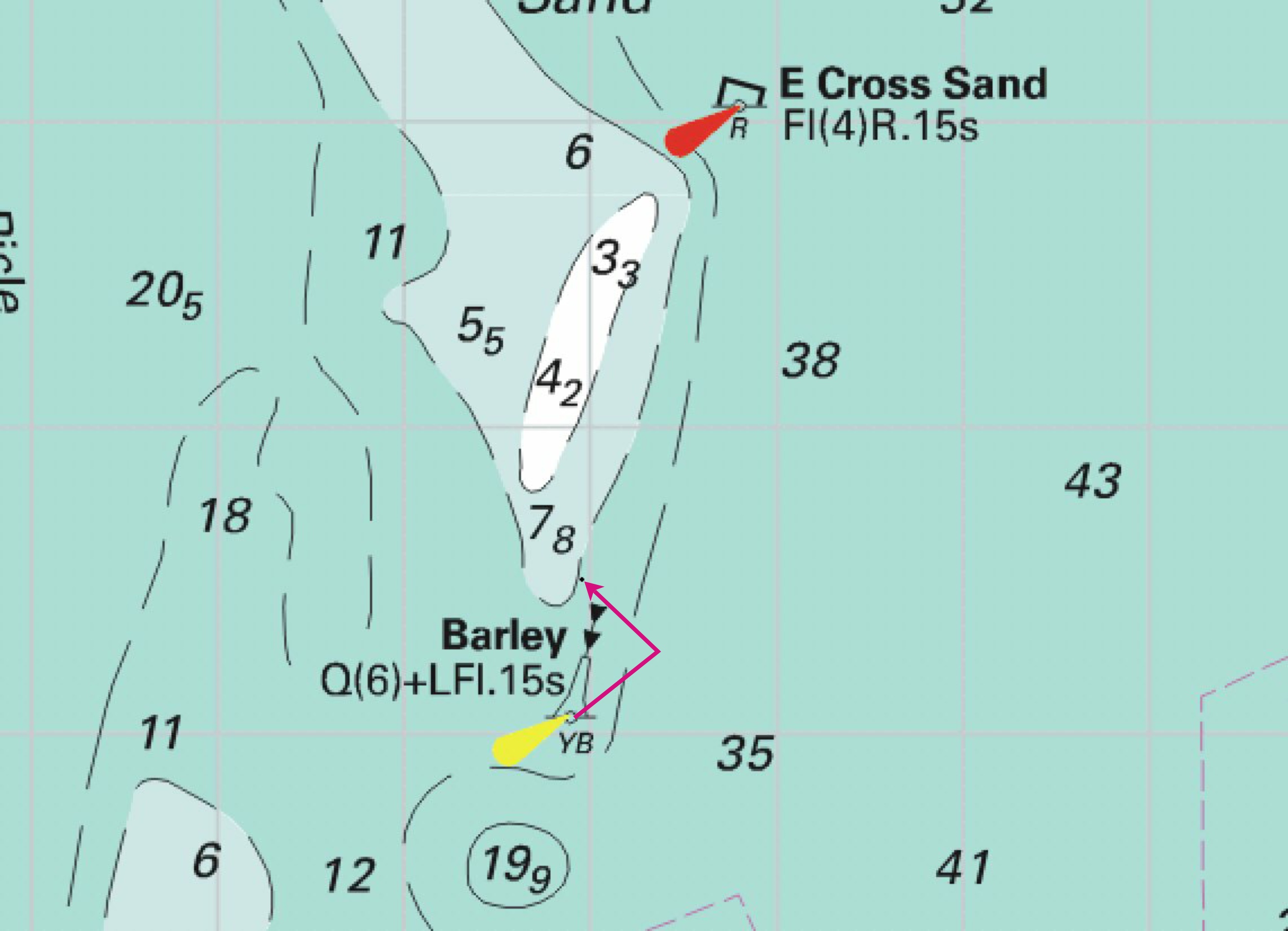
Affects: UKHO SNC: 1183, 1610, 1975 and 2692. UKHO SCC: 5607.2 Imray Full Charts: C1 Imray Leisure Folios 2100.1 This notice confirms the previous notice from Trinity House back in Week 22 that the Long Sand Head NCB was moved and an additional ECB (East Long Sand Head) was installed in the previous position of the NCB.
|
|
Week 25 |
ENGLAND - Insert: depth, 0.5, enclosed by 2m contour at 51° 43´·65N., 1° 33´·91E. Delete depth, 6.6, close SE. depth, 0.7, enclosed by 2m contour at 51° 43´·09N., 1° 33´·52E. Delete depth, 4.1, close W. depth, 0.6, and extend 2m contour SE to enclose 51° 41´·49N., 1° 38´·17E. Delete depth, 0.7, close NW. depth, 0.5 , and extend 2m contour N to enclose 51° 38´·07N., 1° 37´·44E. Delete depth, 2.3, close SE. Notice 2796 refers Base image courtesy of Imray ID10 Chart C1 and Meridian Chartware.
|
Affects: UKHO SNC: 1183 and 1975 UKHO SCC: 5607.2 Imray Full Charts: C1 Imray Leisure Folios 2100.1 This notice has 4 reduced soundings, 2 on the east side of the Long Sand and 2 on the east side of the Kentish Knock. There have been two previous Notices this year in the same two areas: NtM 1880 and 2107. That provides a total of 5 reduced depths on the east side of the Long Sand and 7 on the east side of the Kentish Knock. The images shows all the new depths.
|
|
Week 24 |
ENGLAND - Insert depth, 4, and extend 5m contour NE to enclose 51° 33´·36N., 1° 23´·60E. Delete depth, 5.3, close SE. Notice 2654 refers Base image courtesy of Imray ID10 Chart IN5043 and Meridian Chartware.
|
Affects: UKHO SNC: 1183, 1606 and 1607. UKHO SCC: 5606.2 Imray Full Charts: C1 Imray Leisure Folios 2000.1 One reduction of depth at the western side of the southern entrance of Fisherman’s Gat. At 4m, unlikely to hinder leisure craft.
|
|
Week 24 |
ENGLAND - Insert: depth, 3.1, and extend 5m approximate contour E to enclose 51° 38´·08N., 1° 19´·56E.
depth, 6.7, and extend 10m approximate contour E to enclose 51° 38´·05N., 1° 19´·68E. Notice 2753 refers Base image courtesy of Imray ID10 Chart IN5043 and Meridian Chartware.
|
Affects: UKHO SNC: 1183 and 1975. UKHO SCC: 5606.6, 5606.2 and 5607.2 Imray Full Charts: C1 Imray Leisure Folios 2000.1 and 2100.1 This notice records two reductions of depth and a wreck at the SW Sunk swatchway. The data is provide by the Port of London Authority dint of their August, 2023 survey. The wreck was identified by us earlier that year and the PLA kindly surveyed the area to identify the safe water over the wreck. We did report the PLA data last year but this is now confirmed. There are two reductions of depth both on the north side of the Black Deep which shows the sands had encroached a little. This will not hinder us. The image I am using is based on the contours shown on 2022 so are a little dated. Please refer to our 2024 download at: https://www.crossingthethamesestuary.com/page29.htm
|
|
Week 22 |
EAST COAST OF ENGLAND - The following alterations to buoyage have taken place: Longsand Head Lighted Buoy Moved to new position: Latitude 51° 48.366’N., Longitude 001° 38.160’E. East Longsand Head Lighted Buoy New station deployed in position: Latitude 51° 48.123’N., Longitude 001° 39.394’E. Characteristics as below: Pillar: Black above Yellow above Black Q (3) 10s East Cardinal Topmark AIS Transmission: MMSI 992351455 “EAST LONGSAND HEAD BUOY” Movement effected consequent upon a recent survey. No further notice will be given. Trinity House Notice to Mariners 5/2024, dated 17th April 2024, previously refers. Trinity House Notice to Mariners No 8 of 2024 refers
|
Affects: UKHO SNC: 1183, 1607, 1975.and 2692 UKHO SCC: 5607.2. Imray Full Charts: C1 Imray Leisure Folios 2000.1 In Week 18, Trinity House provided us notice of intended move of the Longsand Head lighted buoy and the new station of the East Longsand lighted east cardinal buoy. Today they have announced that the changes have now be actioned. The image on Week 18 remains correct.
|
|
Week 20 |
ENGLAND - Insert: depth, 8.2 at 51° 29´·44N., 1° 09´·14E. Delete depth, 7.7, close NW. Notice 2117 refers Base image courtesy of Imray ID10 Chart IN5043 and Meridian Chartware.
|
Affects: UKHO SNC: 1606, 1607 and 1609. UKHO SCC: 5606.5 Imray Full Charts: C1 Imray Leisure Folios 2100.1 One reduction of depth just inside the channel of the Princes Channel between Princes No 5 and No7. Unlikely to hinder leisure craft.
|
|
Week 19 |
ENGLAND - Insert:
depth, 0.5 at 51° 42´·62N., 1° 30´·92E. Delete depth, 1.7, close SE. depth, 06, enclosed by 2m contour at 51° 42´·52N., 1° 30´·62E. Delete depth, 4, close S. depth, 2.8 at 51° 39´·71N., 1° 37´·81E. Delete depth, 7, close SW and depth, 3.5, close SW. depth, 4.3, and extend 5m contour SE to enclose 51° 38´·82N., 1° 37´·65E. Delete depth, 8.3, close NW. depth, 4.4, and extend 5m contour NE to enclose 51° 38´·32N., 1° 37´·70E. Delete depth, 7.1, close NE. depth, 4.3, and extend 5m contour SE to enclose 51° 40´·63N., 1° 38´·11E. Delete depth, 6.6, close S. depth, 2.9, and extend 5m contour SE to enclose 51° 39´·49N., 1° 37´·73E. Delete depth, 7, close SW. Notice 2107 refers Base image courtesy of Imray ID10 Chart C1 and IN5043 and Meridian Chartware.
|
Affects: UKHO SNC: 1183 and 1975. UKHO SCC: 5607.4 and 5607.2. Imray Full Charts: C1 Imray Leisure Folios 2000.1 Two new wrecks on the Gunfleet Sands between the east side of the wind farm and the Old Gunfleet Lighthouse. Probably unwise to try to cross the sands at that point. The Notice also has seven reductions of depth, two very shallow depths on the Long Sand, east side of the London Array wind farm and five reductions of depth along the east side of the Kentish Knock. Probably unwise to cross the Long Sand just east of the wind farm. Three images: of the second image at the Long Sand three other reductions of depth reported by the earlier Notice 1880 has been included.
|
|
Week 18 |
EAST COAST OF ENGLAND - Longsand Head Lighted Buoys On or around the 17th May 2024, the following alterations to buoyage will take place: Longsand Head Lighted Buoy To be moved to new position: Latitude 51° 48.366’N., Longitude 001° 38.160’E. East Longsand Head Lighted Buoy New station to be deployed in position: Latitude 51° 48.123’N., Longitude 001° 39.394’E. Characteristics as below: Pillar: Black above Yellow above Black Q (3) 10s East Cardinal Topmark AIS Transmission: MMSI 992351455 “EAST LONGSAND HEAD BUOY” Movement effected consequent upon a recent survey. Further notice will be given upon buoy deployment. Trinity House Notice to Mariners, 17/04/2024 No 05 of 2024 refers
|
Affects: UKHO SNC: 1183, 1607, 1975.and 2692 UKHO SCC: 5607.2. Imray Full Charts: C1 Imray Leisure Folios 2000.1 This Trinity House Notice gives advance information of changes at the Long Sand Head. On or around 17th May there is a move and a new buoy. Close to the current position of the Longsand Head north cardinal buoy, a new east cardinal buoy will be positioned designated 'East Longsand Head' Light characteristics are shown. Also AIS will be fitted. The Longsand Head north cardinal buoy is moved to the West providing clearance round the Long Sand Head. The image is drawn by me based on Imray showing all recent depths and the intended positions.
|
|
Week 17 |
ENGLAND - Insert: depth, 1 , and extend 2m approximate contour E to enclose 51° 42´·46N., 1° 33´·17E. depth, 0.9 , and extend 2m approximate contour SE to enclose 51° 42´·16N., 1° 32´·86E. depth, 1.1, and extend 2m approximate contour S to enclose 51° 41´·93N., 1° 32´·42E. Delete depth, 3.5, close SW. depth, 0.1 , enclosed by 2m contour 51° 36´·42N., 1° 35´·15E. Delete depth, 5.2, close SE. depth, 0.9 , enclosed by 2m contour 51° 36´·17N., 1° 34´·69E. Delete depth, 8.1, close SW. depth, 0.7 , enclosed by 2m contour 51° 36´·49N., 1° 35´·44E. Notice 1880 refers Base image courtesy of Imray ID10 Chart C1 and Meridian Chartware.
|
Affects: UKHO SNC: 1183, 1607 and 1975. UKHO SCC: 5607.2. Imray Full Charts: C1 Imray Leisure Folios 2000.1 Six reductions of depth, three on the Long Sand and three on the Kentish Knock. The soundings on the Long Sand are outside the Wind Farm to the NE. The three on the Kentish Knock are just outside the south side of the Wind Farm and quite dramatic: i.e. fro8.1m to 0.9. But probably not where we usually go.
|
|
Week 16 |
ENGLAND - Insert: depth, 2.2 at 51° 47´·88N., 1° 37´·22E. Delete depth, 4.5, close NE. depth, 6.9 at 51° 48´·09N., 1° 37´·87E. depth, 11 at 51° 48´·26N., 1° 38´·16E. Notice 1784 refers Base image courtesy of Imray ID10 Chart C1 and Meridian Chartware.
|
Affects: UKHO SNC: 2692. UKHO SCC: 5607.2. Imray Full Charts: C1 Imray Leisure Folios 2000.1 Three new reduced depths for SNC 2692 at the Long Sand Head. A new edition of SNC 2692 was only issued on 28th March! The reduced depths indicate that the Long Sand Head continues the common trend to extend to the NE. I understand it is likely the Long Sand Head North Cardinal which is critical marking the tight corner in the two-
|
|
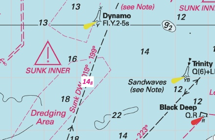
Week 15 |
ENGLAND - Insert: depth, 16.3 at 51° 51´·20N., 1° 36´·22E. Delete depth, 17.1, close E. depth, 16.6 at 51° 51´·12N., 1° 36´·57E. Delete depth, 17.1, close NW. Notice 1597 refers Base image courtesy of Imray ID10 Chart C1 and Meridian Chartware.
|
Affects: UKHO SNC: 1183 and 1975. Note: This update is included in New Edition 2692, published 28 March 2024. UKHO SCC: 5607.2 Imray Full Charts: C1 Imray Leisure Folios 2000.1 Two reductions of depth; this monitoring the DW channel on the Sunk Inner area. Unlikely to hinder leisure craft. The image includes a reduced depth vide NtM 1470 previously.
|
|
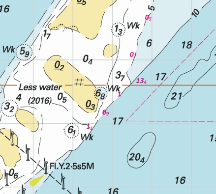
Week 15 |
ENGLAND - Insert: depth, 2.7, and extend 5m contour S to enclose 51° 32´·43N., 1° 01´·64E. Delete depth, 4, close NW. depth, 6.2 at 51° 32´·53N., 1° 01´·95E. Delete depth, 6.7, close SW depth, 2.7 at 51° 32´·44N., 1° 01´·60E. Delete depth, 4, close SE. depth, 5.5 at 51° 32´·34N., 1° 01´·23E. Delete depth, 7.2, close SW. depth, 6.1 at 51° 32´·21N., 1° 00´·75E. Delete depth, 7, close E. Replace: depth, 6.5, with depth, 6 at 51° 32´·65N., 1° 02´·22E. depth, 9.1, with depth, 8.6 at 51° 32´·38N., 1° 01´·58E. depth, 1.7, with depth, 1.2, and extend 2m approximate contour S to enclose 51° 32´·43N., 1° 01´·51E. depth, 4.4, with depth, 2.7, and extend 5m contour S to enclose 51° 32´·40N., 1° 01´·47E. Notice 1608 refers Base image courtesy of Imray ID10 Chart IN5043 and Meridian Chartware.
|
Affects: UKHO SNC: 1607 and 1609. UKHO SCC: 5606.6 Imray Full Charts: C1 Imray Leisure Folios 2100.1 Nine reductions of depth at the Mouse channel side of the SW Barrow knoll. If you are a ‘corner cutter’ round the knoll (e.g. to or from the Princes Channel into the West Swin) it is worth seeing the image. Note the edge of that sand is pretty ‘steep-
|
|
Week 14 |
ENGLAND - Insert: depth, 15.8 at 51° 51´·50N., 1° 36´·12E. Delete depth, 16.2, close SE. Notice 1470 refers Base image courtesy of Imray ID10 Chart C1 and Meridian Chartware.
|
Affects: UKHO SNC: 1975. Note: This update is included in New Edition 2692, published 28 March 2024. UKHO SCC: 5607.2 Imray Full Charts: C1 Imray Leisure Folios 2000.1 One reduction of depth NE of the Sunk Inner Mark in line with the DW channel leading to the exit to Felixstowe. Unlikely to hinder leisure craft.
|
|
Week 13 |
ENGLAND - Insert: depth, 9.9, enclosed by 10m contour at 51° 48´·42N., 1° 39´·17E. Delete depth, 10.7, close NW and depth, 10.3, close NW. depth, 10.2 at 51° 48´·63N., 1° 39´·41E. Delete depth, 11.1, close NW and depth, 10.7, close W. depth, 14, enclosed by 15m contour at 51° 49´·84N., 1° 36´·46E. Delete depth, 15.9, close W. Replace: depth, 10.1, with depth, 9.4, enclosed by 10m contour 51° 50´·02N., 1° 35´·82E. Notice 1378 refers Base image courtesy of Imray ID10 Chart C1 and Meridian Chartware.
|
Affects: UKHO SNC: 1183, 1610 and 1975. Note: This update is included in New Edition 2692, published 28 March 2024. UKHO SCC: 5607.2 Imray Full Charts: C1 Imray Leisure Folios 2000.1 A reduction of depth, three of which are in the ‘turn’ of the Long Sand Head two-
|
|
Week 13 |
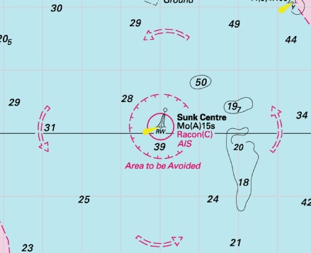
ENGLAND - Amend: Sunk Centre light- Notice 1433 refers Base image courtesy of Imray ID10 Chart C1 and Meridian Chartware.
|
Affects: UKHO SNC: 1183. UKHO SCC: 5606.2 and 5607.2 Imray Full Charts: C1 This notice applies only to the small scale chart of the whole Thames Estuary (SNC 1183). The change is the light characteristics of the Sunk Centre safe water buoy. I believe most charts are all ready correct.
|
|
Week 12 |
ENGLAND - Insert: depth, 8 at 51° 36´·23N., 1° 20´·53E. Delete depth, 8.3, close SW. depth, 8.2 at 51° 36´·12N., 1° 20´·28E. Delete depth, 8.6, close NE. depth, 4.9, and extend 5m approximate contour NE to enclose 51° 35´·50N., 1° 20´·82E. depth, 6.2 at 51° 35´·24N., 1° 21´·21E. Delete depth, 7.1, close SW. depth, 6.3 at 51° 35´·09N., 1° 21´·44E. Delete depth, 6.9, close SW. depth, 5.5 at 51° 35´·57N., 1° 20´·74E. Delete depth, 6.7, close NW. Replace: depth, 9.5, with depth, 9 at 51° 35´·67N., 1° 20´·74E. Notice 1222 refers Base image courtesy of Imray ID10 Chart IN5043 and Meridian Chartware.
|
Affects: UKHO SNC: 1606, 1607 and 1975. UKHO SCC: 5606.2 and 5607.2 Imray Full Charts: C1 Imray Leisure Folios 2100.1 and 2000.1 7 reduction of depth in Fisherman’s Gat. Still ample water for leisure craft and still just outside the west side of the buoyage. But note there is a just the suggestion that the drying patch of the Long Sand on the mid-
|
|
Week 12 |
ENGLAND - Insert: depth, 9 at 51° 53´·03N., 1° 31´·00E. Delete depth, 9.9, close NW. Notice 1304 refers Base image courtesy of Imray ID10 Chart C1 and Meridian Chartware.
|
Affects: UKHO SNC: 1183. Note: This update is included in New Edition 2692, published 28 March 2024. UKHO SCC: 5607.2 Imray Full Charts: C1 Imray Leisure Folios: 2000.1 One reduction of depth on the east edges of the Roughs Shoals. At 9m, unlikely to hinder leisure craft.
|
|
Week 11 |
New Editions of ADMIRALTY Charts on 28th March, 2024 Standard National Charts Chart 2692 England - Small Craft Charts SCC 5605.8 Dover to Deal. 1:37,500 SCC 5605.9 Deal to Ramsgate. 1:37,500 SCC 5607.4 Southern Approaches to Harwich. 1:50,000 SCC 5607.5 Harwich to Orford Ness. 1:50,000 SCC 5607.6 A Approaches to Harwich and Woodbridge Haven. 1:25,000 B Continuation of River Deben. 1:25,000 SCC 5607.7 Rivers Stour and Orwell. A River Stour. 1:25,000 B River Orwell. 1:25,000 C Ipswich. 1:10,000 SCC 5607.8 A Rivers Ore and Alde. 1:25,000 B Orford Haven and Approaches. 1:25,000 |
Includes changes to depths from the latest British Government and Port of London Authority surveys. Includes full updates for New Edition and Notices to Mariners affecting source charts. |
|
Week 10 |
ENGLAND - Insert: depth, 2.4 at 51° 42´·05N., 1° 25´·32E. Delete depth, 3.9, close N. depth, 0.7 at 51° 41´·83N., 1° 25´·65E. Delete depth, 0.9, close SW. depth 4.6, and extend 5m contour NW to enclose 51° 41´·75N., 1° 23´·95E. Delete depth, 6.7, close W. depth, 2.9 at 51° 41´·18N., 1° 24´·13E. Delete depth, 3.1, close SE. Notice 1026 refers Base image courtesy of Imray ID10 Chart IN5043 and Meridian Chartware.
|
Affects: UKHO SNC: 1183 and 1975. UKHO SCC: 5606.2 and 5607.2 Imray Full Charts: C1 Imray Leisure Folios 2100.1 and 2000.1 Four reductions of depth on the Little Sunk, two of which are on the usual crossing point and two indicating a slight growth of the Little Sunk knoll. This change is caused by our 2023 survey and the crossing point is NOT significantly affected. At the moment the growth of the Little Sunk appears to be quite slow, indeed the worse depth of 0.7m looked like the ‘crest’ of a sand wave.
|
|
Week 08 |
ENGLAND - Insert depth, 15.7 at 51° 48´·91N., 1° 33´·34E. Delete depth, 16, close NE. Notice 769 refers Base image courtesy of Imray ID10 Chart C1 and Meridian Chartware.
|
Affects: UKHO SNC: 2692 UKHO SCC: 5607.1 Imray Full Charts: C1 Imray Leisure Folios: 2100.1 One slight reduction of depth right on the line of the Sunk/Black Deep deep water channel. Obviously the PLA monitors the depth of that channel rigorously. At 15.7m unlikely to hinder leisure craft but don’t linger!
|
|
Week 07 |
ENGLAND - Insert: depth, 4, and extend 5m contour SE to enclose 51° 32´·43N., 1° 01´·61E. Notice 638 refers Base image courtesy of Imray ID10 Chart IN5043 and Meridian Chartware.
|
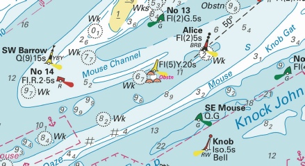
Affects: UKHO SNC: 1607 and 1609 UKHO SCC: 5606.6 Imray Full Charts: C1 Imray Leisure Folios: 2100.1 One reduction of depth in the Mouse Channel east of the SW Barrow cardinal buoy. Unlikely to hinder leisure craft. The Image also includes the detail of NtM 335 regarding the new ‘obstn’ west of the ‘Alice’ Danger mark.
|
|
Week 05 |
ENGLAND - Insert:
Notice 447 refers Base image courtesy of Imray ID10 Chart IN5043 and Meridian Chartware.
|
Affects: UKHO SNC: 1607 and 1609 UKHO SCC: 5606.5 Imray Full Charts: C1 Imray Leisure Folios: 2100.1 This is a catch-
|
|
Week 04 |
ENGLAND - Insert:
Notice 335 refers Base image courtesy of Imray ID10 Chart IN5043 and Meridian Chartware.
|
Affects: UKHO SNC: 1607 and 1609 UKHO SCC: 5606.6 and 5606.2 Imray Full Charts: C1 Imray Leisure Folios: 2100.1 A new ‘obstn’ in the Mouse Channel east of the SW Barrow west cardinal buoy and west of the ‘Alice’ danger buoy. Adjacent to the new ‘obstn’ are three unlit Orange buoys; all these close to an existing lit yellow special buoy.
|
|
Week 03 |
ENGLAND - Insert: depth, 4.3, and extend 5m contour N to enclose 51° 33´·27N., 1° 17´·39E. Delete depth, 6.3, close NW. depth, 7.9 at 51° 33´·34N., 1° 18´·34E. Delete depth, 8.4, close SW. depth, 6.8 at 51° 33´·24N., 1° 19´·27E. Delete depth, 7.7, close SW. depth, 6 at 51° 33´·16N., 1° 19´·61E. Delete depth, 7.3, close SE. Replace: depth, 8, with depth, 7.3 at 51° 32´·98N., 1° 20´·25E. Notice 196 refers Base image courtesy of Imray ID10 Chart IN5036 and Meridian Chartware.
|
Affects: UKHO SNC: 1183, 1606 and 1607 UKHO SCC: 5606.6 and 5606.2 Imray Full Charts: C1 Imray Leisure Folios: 2100.1 5 reductions of depth in the North Edinburgh Channel. None of the reductions are likely to hinder leisure craft and if that is all affecting the North Edinburgh channel it is logical that the Channel remains as it used to be. No buoyage of course.
|
|
Week 01 |
ENGLAND - Note: This update is included in New Edition 2052, published 28 December 2023. Insert: depth, 15.2 at 51° 48´·78N., 1° 37´·39E. Delete depth, 16.3, close NW. Notice 29 refers Base image courtesy of Imray ID10 Chart C1 and Meridian Chartware.
|
Affects: UKHO SNC: 1975 and 2692 UKHO SCC: 5607.2 Imray Full Charts: C1 Imray Leisure Folios: 2000.1 and 2100.1 One reduction of depth in the Long Sand Head two-
|
 Wk
Wk 


-1.jpg)
.jpg)
 Unexploded Ordnances (2024)
  at 51° 28´·67N., 0° 44´·15E.
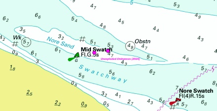

 Fl(5)Y.20s and
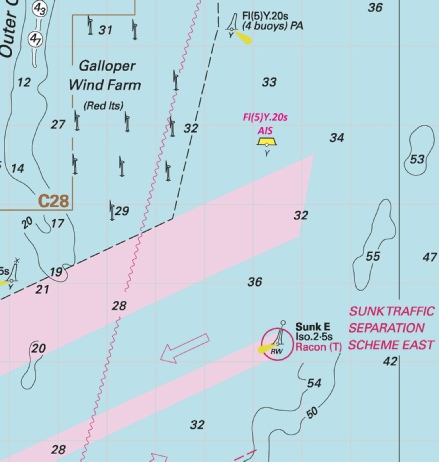
 at 51° 37´·77N., 1° 35´·43E.
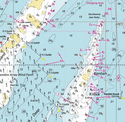
%2024.jpg)
%2024.jpg)
 Fl.G.5s
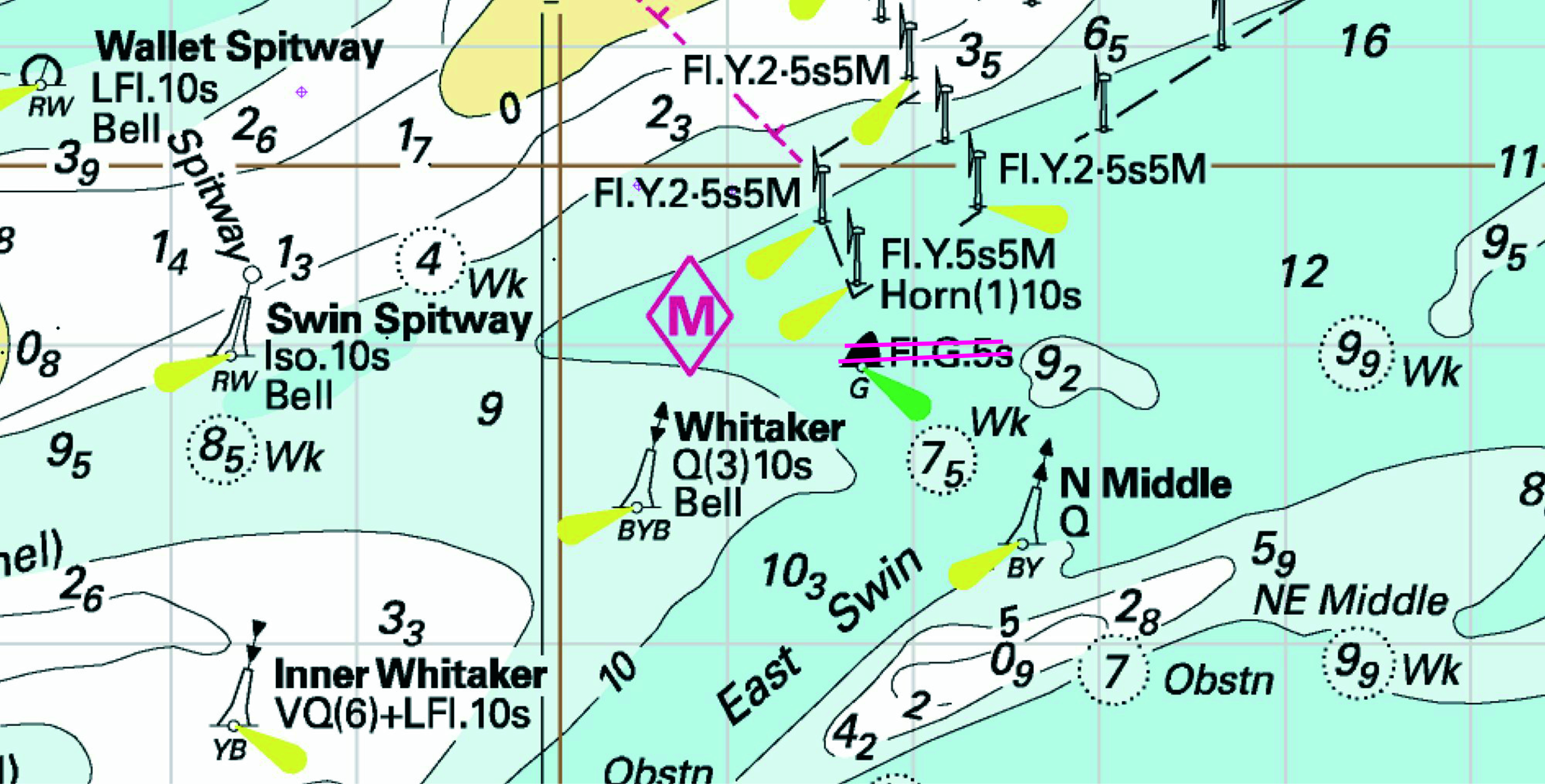

 VQ Long Sand Head
 Wk
Wk 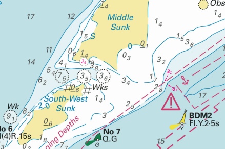


 at 51° 31´·92N., 1° 02´·86E.
 (3 buoys)