|
Notices - |
||
|
Week 20 |
BELGIUM - Works are in progress within the buoyed entry prohibited area, centred on position 51° 31´·86N., 2° 29´·86E. A pile with light, Mo(U)15s17m10M and Automatic Identification System (AIS), have been established in position 51° 31´·61N., 2° 29´·89E. Mariners are advised to navigate with caution in the area. Notice 2082(T) refers Base image is from Imray chart C30 by courtesy of Imray and Meridian Chartware.
|
Affects: UKHO SNC: 1406, 1630 and 2449. Belgium SNC: BE11 UKHO SCC: 5606.1 and 5607.1 Imray Full Charts: C30 A temporary notice announcing a new pile and light right in the centre of the cluster of cardinal buoys marking the works area for the development of the new Princess Elisabeth Island. This is in Belgium waters east of the Twin special buoy marking the east side of the Noord Hinder TSS. Work creating the new island is now in progress.
|
|
Week 19 |
BELGIUM - Insert:
pile, . at: 51° 18´·90N., 3° 06´·45E. 51° 18´·87N., 3° 06´·50E. 51° 18´·84N., 3° 06´·56E. 51° 18´·81N., 3° 06´·61E. 51° 18´·78N., 3° 06´·67E. Move:
Delete:
Notice 1930 refers Base image is from Imray chart C2120.4 by courtesy of Imray and Meridian Chartware.
|
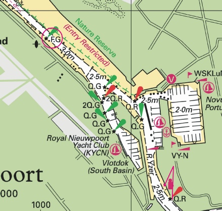
Affects: Belgium SNC: 1BE101 (Panel D, Blankenberge). Imray Full Charts: C30 Imray Leisure Charts: 2120.4 The notice shows some of the progress at the entrance into Blankenberge. In 2024, an area to the north and west of the previous western mole was significantly increased. This notice announces a new starboard (western) light at the entrance of the harbour, five new piles within the western side of the channel and a new FG light just before where the channel widens into the harbour.
|
|
Week 15 |
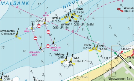
BELGIUM - Insert:
Notice 1587 refers Base image is from Imray chart C30 by courtesy of Imray and Meridian Chartware.
|
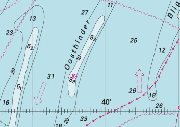
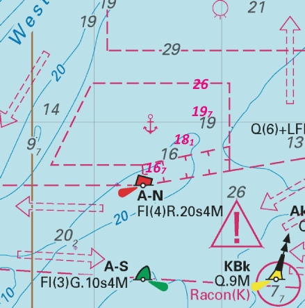
Affects: UKHO SNC: 1406 and 2449 UKHO SCC: 5606.1 and 5607.1 Imray Full Charts: C30 In week 36 of last year, Notice 4041 announced a ring of cardinal buoys and yellow special buoys placed to marked the intended Princess Elisabeth Island west of the Westhinder bank and east of the NE heading TSS. This is for the new energy hub to be built in the future. This notice simply names one of the yellow special buoys!
|
|
Week 13 |
ENGLAND - Submarine cable laying works are taking place between North Foreland and Oostende, along a line joining the following positions: 51° 22´·73N., 1° 26´·80E. 51° 23´·45N., 1° 29´·81E. 51° 23´·15N., 1° 32´·74E. 51° 23´·55N., 1° 33´·52E. 51° 23´·55N., 1° 36´·37E. 51° 23´·75N., 1° 38´·91E. 51° 22´·61N., 1° 43´·78E. 51° 22´·72N., 1° 45´·28E. 51° 22´·45N., 1° 48´·39E. 51° 22´·53N., 2° 03´·45E. 51° 22´·63N., 2° 06´·71E. 51° 22´·36N., 2° 08´·59E. 51° 22´·53N., 2° 12´·70E. 51° 21´·80N., 2° 14´·73E. 51° 21´·37N., 2° 17´·93E. 51° 21´·59N., 2° 22´·00E. 51° 22´·47N., 2° 27´·09E. 51° 22´·27N., 2° 28´·42E. 51° 22´·23N., 2° 32´·09E. 51° 21´·27N., 2° 33´·95E. 51° 20´·89N., 2° 40´·56E. 51° 21´·28N., 2° 41´·97E. 51° 21´·00N., 2° 44´·40E. 51° 17´·38N., 2° 47´·99E. 51° 13´·57N., 2° 53´·85E. Charts will be updated when works are complete. This change will be included in a New Edition of Chart 1607. Mariners are advised to navigate with caution in the area. Notice 1339(P) refers Base image is from Imray chart C30 by courtesy of Imray and Meridian Chartware.
|
Affects: UKHO SNC: 323, 1183, 1406, 1610, 1630, 1828 and 2449. Belgium SNC: BE11 and BE102 UKHO SCC: 5605.1, 5605.11, 5606.1, 5606.2, 5606.4 and 5607.1. Imray Full Charts: C30 A submarine cable between North Foreland and the Oostende is to be laid pretty much west to east until off Oostende. No doubt there will be VHF broadcasts when working.
|
|
Week 10 |
Reproductions of Belgian Government Charts published 6th March 2025 Chart BE11 North Sea, Vlaamse Banken from Gravelines to Oostkapelle. 50°59´·95 N. - Chart BE101 (INT 1474) International Chart Series, North Sea, Belgium and Netherlands from Oostende to Westkapelle. 51°12´·95 N. - A Brugge. 51°13´·30 N. - B Zeebrugge Achterhaven. 51°17´·58 N. - C Zeebrugge Voorhaven. 51°19´·55 N. - D Blankenberge. 51°18´·52 N. - Chart BE102 (INT 1480) International Chart Series, North Sea, France and Belgium from Dunkerque to Oostende. 51°02´·95 N. - A Nieuwpoort. 51°08´·00 N. - B Oostende. 51°13´·37 N. - UK SN Charts to be withdrawn on 6th March, 2025 SN Chart 1872 North Sea, Dunkerque to Vlissingen. SN Chart 1873 (INT 1480) International Chart Series, North Sea, Dunkerque to Oostende. SN Chart 1874 (INT 1474) International Chart Series, North Sea, Westerschelde Oostende to Westkapelle. |
Announcing several new charts from Belgium is because the UKHO versions will cease on 6th March. Previously Belgium issued chart new editions and the UKHO would then adopt them as ADMIRALTY charts a few months later. Now the UKHO will publish the Belgian Charts in their own series as BE charts, but both the UKHO version and Belgium’s will be the same and updated at the same time. NMs for the four new BE Charts (BE 11, BE101, BE102 and BE 106) will be issued through UKHO NM bulletin as normal and available from the website. Chart 1872 is to be deleted from Notices 3183(T)/23, 3999(T)/24, 286(T)/25, 771(T)/25 and 866(T)/25. Chart 1873 is to be deleted from Notices 3183(T)/23, 286(T)/25, 771(T)/25 and 1123(T)/25. On withdrawal of this chart former Notice 5099(T)/24 is cancelled. Chart 1874 is to be deleted from Notices 3183(T)/23, 3999(T)/24, 771(T)/25 and 1123(T)/25. |
|
Week 7 |
BELGIUM - Yellow special purpose light- Buoy Type Position Conical 51° 14´·22N., 2° 48´·62E. Conical 51° 13´·40N., 2° 49´·60E. Can 51° 12´·58N., 2° 50´·35E. Notice 771(T) refers Base image is from Imray chart C2120.3 by courtesy of Imray and Meridian Chartware.
|
Affects: UKHO SNC: 1872, 1873, 1874 and 2449. UKHO SCC: 5605.11 Imray Full Charts: C30 Imray Leisure Folios: 2120.3 A temporary notice announcing three new lit yellow special buoys west of Oostende harbour.
|
|
SCROLL DOWN FOR 2024 NOTICES |
||
|
Week 51 |
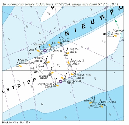
BELGIUM - Insert: limit of restricted area, entry prohibited, pecked line, joining: 51° 10´·50N., 2° 37´·12E. 51° 10´·74N., 2° 38´·01E. 51° 09´·87N., 2° 38´·60E. 51° 09´·61N., 2° 37´·72E. Delete: former limit of restricted area, entry prohibited, pecked line, joining: 51° 10´·59N., 2° 36´·78E. 51° 10´·96N., 2° 38´·14E. 51° 09´·79N., 2° 38´·94E. 51° 09´·40N., 2° 37´·59E. Move: Q ZB9- Q ZB1- Q(6)+LFl.15s ZB4- Q(6)+LFl.15s ZB6- Chart 1873 Insert the accompanying block, centred on: 51° 10´·2N., 2° 38´·1E. Notice 5774 refers Base image courtesy of Imray Chart C2120.3 and Meridian Chartware. The UKHO block is copyright of the UKHO.
|
Affects: UKHO SNC: 1872. 1873 and 2449. UKHO SCC: 5605.11 Imray Full Charts: C30 Imray Leisure Charts: C2120.3 A restricted area to the north-
|
|
Week 49 |
BELGIUM - Insert: limit of reclamation area, pecked line, joining: 51° 18´·973N., 3° 06´·340E. 51° 18´·971N., 3° 06´·352E. 51° 18´·957N., 3° 06´·376E. 51° 18´·878N., 3° 06´·468E. and 51° 18´·913N., 3° 06´·340E. 51° 18´·862N., 3° 06´·417E. 51° 18´·764N., 3° 06´·634E. 51° 18´·762N., 3° 06´·651E. legend, Being reclaimed (2024), centred on: 51° 18´·825N., 3° 06´·487E. fog signal, Horn Mo(U)30s, at light 51° 18´·909N., 3° 06´·561E. Delete: charted detail within the reclamation area. Move:
Notice 5462 refers The base image courtesy of Imray Chart C2120+4 and Meridian Chartware.
|
Affects: UKHO SNC: 1872 (Panel, Blankenberge). UKHO SCC: 5606.10 (Panel A, Mouth of River Medway and West Swale) and 5606.9. Imray Full Charts: C30 Imray Leisure Folios 2120+4 This Notice should be read in conjunction with Notice 5349 in week 47 which variously reports land reclamation and a prohibitive area on the western side of the Blankenberge Harbour entrance. The new east cardinal buoy reported in week 47 is moved slightly to the west and the addition of a fog signal at the current western arm of the harbour entrance.
|
|
Week 47 |
BELGIUM - Insert: limit of restricted area, entry prohibited, pecked line, joining: 51° 18´·89N., 3° 06´·17E. 51° 18´·99N., 3° 06´·32E. 51° 18´·93N., 3° 06´·42E. 51° 18´·88N., 3° 06´·47E.
Move:
Delete former limit of restricted area, entry prohibited, pecked line, joining: 51° 18´·89N., 3° 06´·17E., 51° 19´·04N., 3° 06´·10E. and 51° 18´·88N., 3° 06´·47E. Notice 5349 refers The base image courtesy of Imray Chart C2120.4A and Meridian Chartware.
|
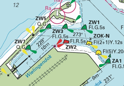
Affects: UKHO SNC: 1872 (Panel Blankenberge), 1872 and 1874. UKHO SCC: 5605.11. Imray Full Charts: C30 Imray Leisure Folios 2120.4A The restricted area just to the west of the entrance to Blankenberge harbour has been redefined and marked by a moved north cardinal beacon and east cardinal buoy.
|
|
Week 38 |
BELGIUM - Amend: legend to, Historic Wk (see Note), at wreck: 51° 27´·63N., 3° 06´·55E. 51° 24´·42N., 2° 49´·09E. 51° 28´·93N., 2° 41´·35E. Replace: Notices 4235 and 4295 refers The base image courtesy of Imray ID10 Chart C30 and Meridian Chartware.
|
Affects: UKHO SNC: 1630, 1406, 1872, 1873 and 2449. UKHO SCC: 5605.1 (Panel B, Northern Approaches to Dover Strait), 5606.1 and 5607.1. Imray Full Charts: C30 One change of depth over an existing wreck east of the Westhinder and notification of three wrecks now designated as ‘Historic’. All unlikely to hinder leisure craft.
|
|
Week 36 |
BELGIUM - Insert:
Notice 4041 refers The base image courtesy of Imray ID10 Chart C30 and Meridian Chartware.
|
Affects: UKHO SNC: 1406, 1972 and 2449. UKHO SCC: 5606.1 and 5607.1. Imray Full Charts: C30 This Notice duplicates Notice 2008 this year to amend further SNC and SC charts. This notice announces a family of four cardinal buoys (one each) marking the site of the ‘soon to come’ Princess Elisabeth Island. This is located west of the Westhinder bank and east of the NE going TSS. NtM 783 placed two yellow special buoys earlier this year in the same location. The Belgium plan is from the ELIA group and the object is to create an energy hub which will connect UK, Belgium and Norway. I have linked a brochure with the usual pdf image download. The island is to be built from now to mid 2026 and then the energy hub will be built. The location is probably unlikely to hinder leisure craft given that crossing over the Westhinder bank is best avoided.
|
|
Week 36 |
BELGIUM - Move
Notice 4042 refers The base image courtesy of Imray ID10 Chart C2120.3B and Meridian Chartware.
|
Affects: UKHO SNC: 1973 (Panel A, Oostende). UKHO SCC: 5605.12 (Panel E, Oostende). Imray Full Charts: C30C Imray Leisure Folios 2120.3B A small move to the NE of the OH6 PHB just inside of the Oostende harbour entrance.
|
|
Week 35 |
BELGIUM - A yellow can buoy, Q.Y MOG22, has been established in position 51° 19´·66N., 3° 08´·77E. Notice 3999(T) refers The base image courtesy of Imray ID10 Chart C2120.4 and Meridian Chartware.
|
Affects: UKHO SNC: 1872, 1873 and 2449. Imray Full Charts: C30 Imray Leisure Folios 2120.4 A temporary notice reporting a new lit yellow special buoy close in shore just west of Zeebrugge.
|
|
Week 34 |
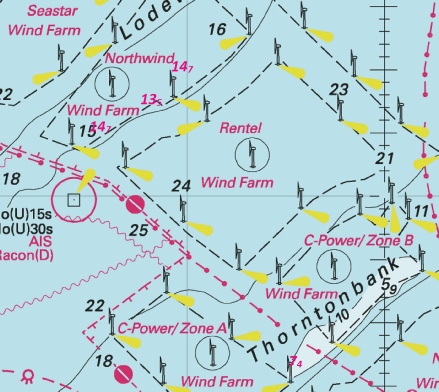
BELGIUM - Insert: depth, 13.5, and extend 20m contour S to enclose 51° 36´·50N., 2° 54´·17E. Delete depth, 15.3, close NW. depth, 7.4, and extend 10m contour W to enclose 51° 32´·39N., 2° 57´·73E. Delete depth, 9.7, close E. depth, 9.1, and extend 10m contour SE to enclose 51° 26´·42N., 2° 19´·39E. Delete depth, 9.9, close NW. depth, 14.7 at 51° 36´·08N., 2° 52´·64E. Delete depth, 15.3, close W. depth, 14.7 at 51° 37´·03N., 2° 54´·97E. Delete depth, 16.5, close SE. Notice 3874 refers The base image courtesy of Imray ID10 Chart C30 and Meridian Chartware.
|
Affects: UKHO SNC: 1406, 1610, 1872, 1873, 1874 and 2449. UKHO SCC: 5606.1 and 5607.1. Imray Full Charts: C30 One reduction of depth on the Fairy Bank east of the Noord Hinder TSS and 4 reductions of depth within the Belgium Wind Farms, all with ample water for leisure craft.
|
|
Week 30 |
BELGIUM - Note: Leading line remains unchanged. Insert: depth, 8.7 at 51° 31´·45N., 2° 37´·83E. Delete depth, 9.2, close S. depth, 13.2 at 51° 24´·46N., 3° 01´·18E. depth, 9.9, and extend 10m contour SE to enclose 51° 23´·97N., 2° 58´·94E. depth, 3.7, enclosed by 5m contour at 51° 17´·51N., 2° 51´·44E. Delete depth, 5.1, close SW Replace:
Insert:
Delete:
Notice 3499 refers Base image courtesy of Imray ID10 Chart C30 and C2120.4 and Meridian Chartware.
|
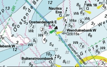
Affects: UKHO SNC: 1406, 1872 (Panel, Blankenberger), 1872, 1873, 1874 and 2449. UKHO SCC: 5605.11, 5606.1 and 5607.1. Imray Full Charts: C30 Imray Leisure Folios 2120.4. A very eclectic NtM involving 4 reductions of depth in three different areas of the Flemish coast, one new north cardinal beacon outside Blankenberge and changes in Blankenberge. The reductions of depth are one on the Oosthinder bank in the middle of the Noord Hinder TSS, two off the approaches to Zeebrugge and one close to the Oostendebank East SHB. All are unlikely to hinder leisure craft. One new lit north cardinal beacon marking the approaches to Blankenberge (which is close by a yellow special buoy that was introduced earlier this year – included in the image)
In Blankenberge, in the channel they have two new red, white and red beacons (lit as before) and in the marina two lights are removed and substituted with two beacons. 5 images!
|
|
Week 28 |
BELGIUM - Replace depth, 23, with depth, 22.5 at 51° 19´·74N., 2° 33´·90E. depth, 13.5, with depth, 13.2 at 51° 20´·19N., 2° 35´·61E. depth, 2.9, with depth, 2.7 at 51° 13´·11N., 2° 36´·15E. depth, 2.9, with depth, 2.7 at 51° 13´·00N., 2° 36´·11E. depth, 18.8, with depth, 18.1 at 51° 24´·52N., 2° 38´·55E. depth, 27, with depth, 26 at 51° 25´·92N., 2° 39´·32E. Insert depth, 1.2 at 51° 10´·36N., 2° 32´·68E. depth, 3 at 51° 12´·04N., 2° 35´·71E. Delete depth, 3.8, close SW. depth, 9.5 at 51° 19´·72N., 2° 34´·78E. Delete depth, 9.9, close NE. depth, 19.7, enclosed by 20m contour at 51° 24´·87N., 2° 40´·41E. depth, 5.7 at 51° 16´·93N., 2° 55´·19E. Delete depth, 6.6, close NE. depth, 7 at 51° 19´·29N., 2° 56´·63E. depth, 3.9 at 51° 19´·78N., 3° 01´·44E. depth, 4.4, and extend 5m contour NE to enclose 51° 22´·99N., 3° 15´·87E. Delete depth, 4.9, close SW. depth, 16.7 at 51° 23´·93N., 2° 37´·49E. Delete:
Notice 3191 refers Base image courtesy of Imray ID10 Chart C30 and Meridian Chartware.
|
Affects: UKHO SNC: 1406, 1872, 1873, 1874 (Panel C, Zeebrugge Voorhaven), 1874 and 2449. UKHO SCC: 5605.11, 5605.1 (Panel B, Northern Approaches to Dover Strait), 5606.1 and 5607.1. Imray Full Charts: C30 Imray Leisure Folios 2110.1, 2120.1 2120.3 and 2120.4 15 reductions of depth in Belgium waters: 3 on Nieuwpoorte Bank, 3 on the Outer Ratel, 4 west off the Akkaert Bank, 3 around the Wenduine Bank and one solitary sounding east of Zeebrugge. Also shre based Red light on the corner of the Wielingendok in Zeebrugge harbour has been deleted. 5 Images!
|
|
Week 26 |
BELGIUM - Insert: submarine cable, , joining: 51° 13´·51N., 2° 53´·86E. 51° 15´·31N., 2° 51´·24E. 51° 18´·65N., 2° 47´·51E. 51° 21´·09N., 2° 46´·05E. 51° 21´·54N., 2° 45´·30E. 51° 21´·91N., 2° 34´·28E. 51° 22´·70N., 2° 29´·58E. 51° 21´·52N., 2° 17´·73E. 51° 22´·15N., 2° 14´·48E. 51° 23´·62N., 2° 12´·15E. 51° 25´·88N., 2° 04´·92E.
Move:
Insert:
Notice 2892 refers Base image courtesy of Imray ID10 Chart C30, C30B and C30E and Meridian Chartware.
|
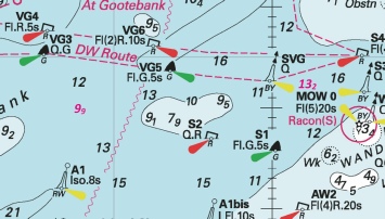
Affects: UKHO SNC: 1872, 1873 (Panel B, Nieuwpoort), 1873, 1874 (Panel C, Zeebruggee Voorhaven) and 1874. UKHO SCC: 5605.12 (Panel D, Nieuwpoort) and 5605.11 Imray Full Charts: C30, C30B and C30E Imray Leisure Folios 2120.3 and 2120.4 Note: Former Notice 2038(P)/22 is cancelled. An eclectic Notice: details of the Belgium side of the England-
|
|
Week 24 |
BELGIUM - Insert:
Delete all NCBs Q at :
Obstn4 at 51° 18´·04N., 3° 03´·97E. Obstn5 at 51° 17´·85N., 3° 03´·46E. Obstn6 at 51° 17´·62N., 3° 02´·96E. Obstn7 at 51° 17´·43N., 3° 02´·45E. Obstn8 at 51° 17´·35N., 3° 02´·24E. Obstn9 at 51° 17´·25N., 3° 02´·02E. Obstn10 at 51° 17´·05N., 3° 01´·56E. Obstn11 at 51° 16´·66N., 3° 00´·68E. Obstn12 at 51° 16´·29N., 2° 59´·83E. Obstn13 at 51° 15´·92N., 2° 58´·98E. Obstn14 at 51° 15´·55N., 2° 58´·03E. Notice 2697 refers Base image courtesy of Imray ID10 Chart C2120.3 and Meridian Chartware.
|
Affects: UKHO SNC: 1872, 1873 and 1874. UKHO SCC: 5605.11 Imray Full Charts: C30 Imray Leisure Folios 2120.3 A new yellow special lit buoy just west of Blankenberg and deletion of 11 north cardinal buoys along the shore between Ostende and Blankenberg.
|
|
Week 21 |
BELGIUM - Delete:
Notice 2254 refers Base image courtesy of Imray ID10 Chart 30C and Meridian Chartware.
|
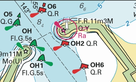
Affects: UKHO SNC: 1873 (Panel A, Oostende). UKHO SCC: 5605.12 (Panel E, Oostende. Imray Full Charts: C30C Imray Leisure Folios 2120.3B (already corrected) Deletion of the yellow lit special buoy on the east side of the harbour entrance, between PHB Nos OH2 and OH6.
|
|
Week 21 |
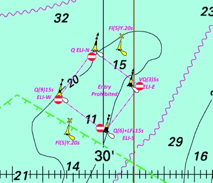
BELGIUM - Insert: limit of restricted area, entry prohibited, pecked line, joining: 51° 31´·59N., 2° 28´·55E. 51° 32´·53N., 2° 29´·69E. 51° 31´·82N., 2° 31´·21E. 51° 30´·87N., 2° 30´·06E. Notice 2258 refers Base image courtesy of Imray ID10 Chart C30 and Meridian Chartware.
|
Affects: UKHO SNC: 1406, 1872 and 2449 UKHO SCC: 5606.8 and 5607.1. Imray Full Charts: C30 This Notice is based on a Belgium Notice which replicates the Dutch Notice in the week previous: Notice 2123 announcing the prohibited area around the intended Princess Elisabeth Island, west of the Westhinder Bank.
|
|
Week 19 |
NORTH SEA - Insert:
Notice 2008 refers Base image courtesy of Imray ID10 Chart C30 and Meridian Chartware.
|
Affects: UKHO SNC: 1630. Imray Full Charts: C30 This notice announces a family of four cardinal buoys (one each) marking the site of the ‘soon to come’ Princess Elisabeth Island. This is located west of the Westhinder bank and east of the NE going TSS. NtM 783 placed two yellow special buoys earlier this year in the same location. The Belgium plan is from the ELIA group and the oject is to create an energy hub which will connect UK, Belgium and Norway. I have linked a brochure with the usual pdf image download. The island is to be built from now to mid 2026 and then the energy hub will be built. The location is probably unlikely to hinder leisure craft given that crossing over the Westhinder bank is best avoided.
|
|
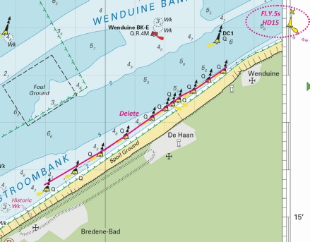
Week 14 |
BELGIUM - Yellow special purpose light- Characteristic Designation Buoy Type Position Fl.Y.5s HD26 Conical 51° 14´·22N., 2° 48´·62E. Fl.Y.5s HD25 Conical 51° 12´·58N., 2° 50´·35E. Notice 1459(T) refers Base image courtesy of Imray ID10 Chart C2120.3 and Meridian Chartware.
|
Affects: UKHO SNC: 1872, 1873, 1874 and 2449. UKHO SCC: 5605.11 Imray Full Charts: C30 Imray Leisure Folios 2120.3 This temporary Notice is placing two new Yellow special lit buoys very close to existing similar buoys either side of the Stroombank west of Ostendee.
|
|
Week 14 |
BELGIUM - Amend: range of light to, 11M at: 51° 09´·35N., 2° 43´·00E, and 51° 09´·42N., 2° 43´·08E. Notice 1475 refers Base image courtesy of Imray ID10 Chart C30B and Meridian Chartware.
|
Affects: UKHO SNC: 2449. Imray Full Charts: C30B Imray Leisure Folios 2120.3 and 2120.3A The pair of lights either side of the entrance into Nieuwpoorte is increased to 11M.
|
|
Week 09 |
BELGIUM - Insert: * depth, 19.7, and extend 20m contour NW to enclose 51° 24´·87N., 2° 40´·41E. Replace: *
*
* = New entries Notice 912 refers Base image courtesy of Imray ID10 Chart C30, C2120.3 and C2120.4 and Meridian Chartware.
|
Affects: UKHO SNC: 1406, 1630 and 2449. UKHO SCC: 5605.1 (Panel B, Northern Approaches to Dover Strait), 5606.1 and 5607.1 Imray Full Charts: C30 Imray Leisure Folios 2120.3 and 2140.4 This Notice follows on the Notice 766 from last week about a number of revised depths over wrecks and Obstn in Belgium waters. This notice repeats 6 revised depths over wrecks dealt with last week to include SNC 1630. That leaves us with one revised depth at the east edge of the Westhinder Ships anchorage which has over 19m, a revised depth of 15.8 over a wreck well osshore off Oostende and a revised depth over an ‘obstn’ of 2.3m which is 4nm north of Zeebrugge Harbour entrance. Three images.
|
|
Week 08 |
BELGIUM - Replace:
Notice 766 refers Base image courtesy of Imray ID10 Chart C30, C2120.3 and C2120.4 and Meridian Chartware
. |
Affects: UKHO SNC: 323, 1406, 1872, 1873, 1874 and 2449 UKHO SCC: 5605.11, 5605.1 (Panel B, Northern Approaches to Dover Strait) and 5606.1. Imray Full Charts: C30 Imray Leisure Folios: 2120.3 and 2120.4 Thirteen revised depths over wrecks in Belgium waters. Surprisingly 12 of the depths are less than previously recorded despite 10 of then being previously swept. Five of the wrecks are located in the West Hinder TSS, their approaches or adjacent. All are in deep water and will not hinder a leisure craft. Four wrecks are around the approaches to Oostende. One at 1.4m on the edge of the Stroombank is worth noting in particular. The final four wrecks are on the approaches to Zeebrugge and are previously marked (obviously) and are unlikely to hinder leisure craft. Three images.
|
|
Week 08 |
BELGIUM - Insert:
51° 30´·82N., 2° 28´·81E. sounding out of position, 9.2 at 51° 24´·62N., 2° 32´·75E. Delete depth, 9.7, close SW. Notice 783 refers Base image courtesy of Imray ID10 Chart C30 and Meridian Chartware.
|
Affects: UKHO SNC: 1406, 1630, 1872 and 1873 UKHO SCC: 5606.1 and 5607.1 Imray Full Charts: C30 Two new yellow special lit buoys between Fairy Bank and the Noordhinder – that’s west of the Noord Hinder South TSS. There is also an adjustment of depth east of the West Hinder bank. Unlikely to hinder leisure craft.
|
|
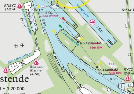
Week 06 |
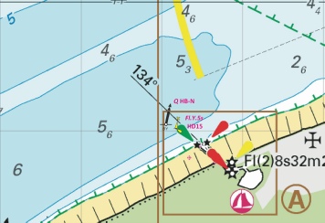
BELGIUM - Note: Red all round light and light description, F.R.19m11M, on charts 1873 and 5605.12 remain unchanged. Chart 1872 [ previous update 302/24 ] WGS84 DATUM Delete limit of restricted area, entry prohibited, 51° 07´·96N., 2° 33´·51E. 51° 07´·85N., 2° 33´·61E. 51° 07´·95N., 2° 33´·89E. 51° 08´·06N., 2° 33´·79E. limit of restricted area, entry prohibited, 51° 06´·97N., 2° 34´·55E. 51° 06´·86N., 2° 34´·65E. 51° 06´·95N., 2° 34´·87E. 51° 07´·05N., 2° 34´·76E. legend, Buoyed (occas), centred on: 51° 08´·22N., 2° 33´·33E. 51° 06´·76N., 2° 34´·64E. Amend: light to, Iso.4s36m18M 51° 13´·800N., 2° 55´·892E. light to, Iso.4s50m18M 51° 13´·631N., 2° 56´·095E. Delete: yellow light flare and associated light description, Q.Y, at light at 51° 14´·514N., 2° 55´·179E. Notice 629 refers Base image courtesy of Imray ID10 Chart C2120.3 and Meridian Chartware.
|
Affects: UKHO SNC: 1872, 1873, 1873 (Panel A, Oostende) and 1874 UKHO SCC: 5605.11 and 5605.12 (Panel E, Oostende) Imray Full Charts: C30 Imray Leisure Folios: 2120.3 Three changes in Belgium waters. First (small) two prohibited areas are defined on the Trapegeer bank off the De Panne coast with two occasional buoys associated with the prohibited area. Second light characteristics are changed for two lights within Oostende harbour (height and range changes). Third, the yellow light at the eastern entrance of Oostende harbour is deleted. Of course the lighthouse close-
|
|
Week 03 |
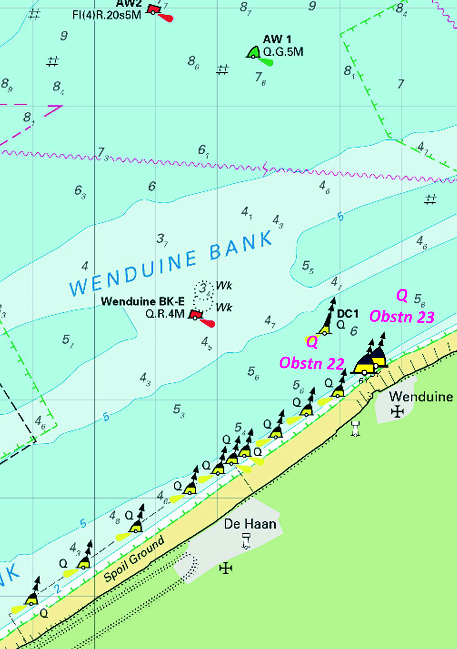
BELGIUM - Insert:
Notice 174 refers Base image courtesy of Imray ID10 Chart C2120.3 and Meridian Chartware.
|
Affects: UKHO SNC: 1872 and 1874 UKHO SCC: 5605.11 Imray Full Charts: C30 Imray Leisure Folios: 2120.3 Two new north cardinal buoys just off Wenduine, east of De Hann and Oostende. These are additional to a line of such buoys that mark the obstructions along the shore..
|


-1.jpg)
 F.G.7m2M at 51° 18´·94N., 3° 06´·39E.
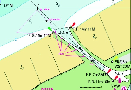
 Fl(5)Y.20s TME1
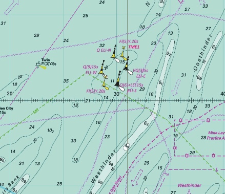
-1.jpg)
-1.jpg)
 Q(3)10s HBE
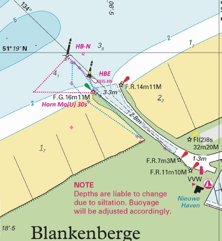
 Q(3)10s HBE
  Q HB-
Q HB-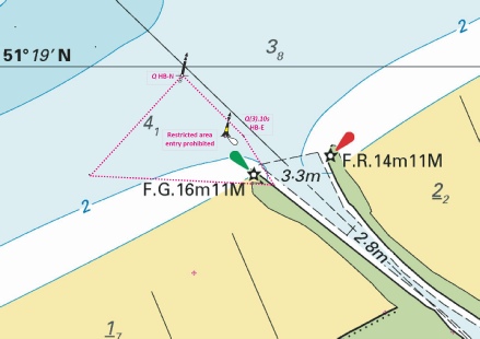

 at 51° 23´·15N., 2° 28´·45E.
 Q ELI-
 VQ(3)5s ELI-
 Q(6)+LFl.15s ELI-
 Q(9)15s ELI-
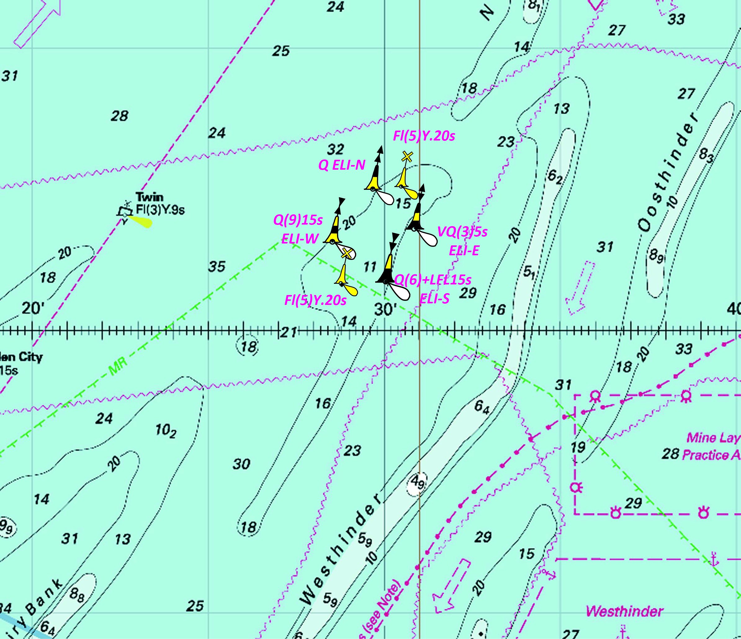
 Q.R OH6
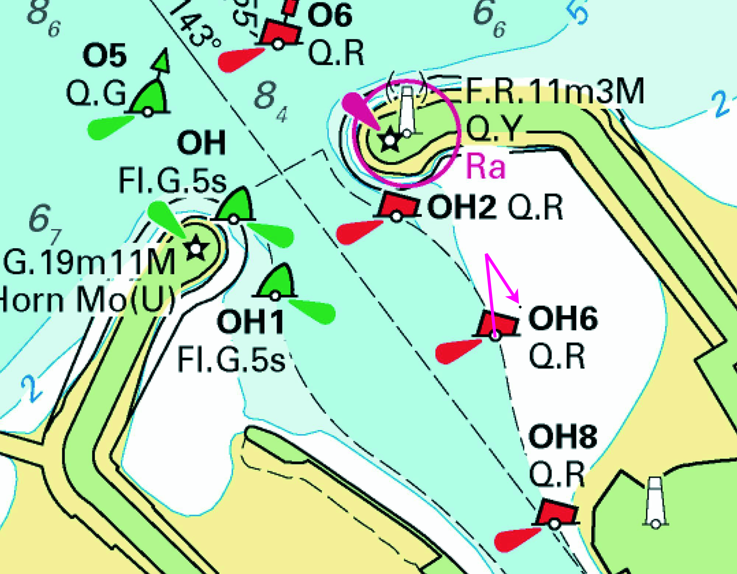
%2024.jpg)

 Q HB-
Q HB- (2 beacons) at
  , close NW of:
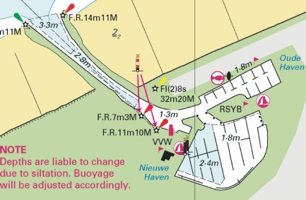
 F.R at 51° 21´·41N., 3° 11´·01E.
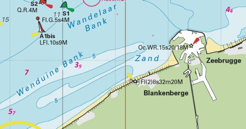

 Fl.Y.5s HD15
 Fl(5)Y.20s
 Q ELI-
 VQ(3)5s ELI-
 Q(6)+LFl.15s ELI-
 Q(9)15s ELI-
.jpg)

 Obstn
Obstn 


 at 51° 22´·23N., 2° 29´·55E.


 at 51° 24´·42N., 2° 49´·09E.
 with
with  at 51° 22´·70N., 3° 05´·24E.
 ,
,  ,
, 


 at 51° 22´·16N., 2° 26´·23E.
 at 51° 22´·55N., 2° 29´·25E.
 at 51° 23´·47N., 2° 35´·90E.


 at 51° 11´·94N., 2° 44´·97E.
 at 51° 14´·78N., 2° 55´·39E.
 at 51° 24´·74N., 3° 06´·58E.


 at 51° 22´·72N., 3° 05´·20E.


 Fl(5)Y.20s
 , and associated legend,
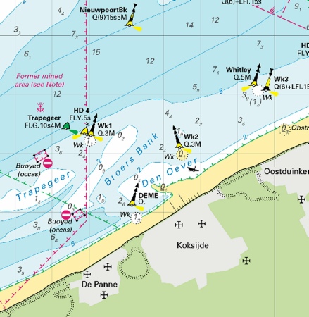
 Q Obstn23