|
Notices - |
||
|
Week 23 |
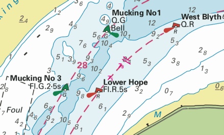
ENGLAND - Insert: depth, 5.9 at 52° 34´·715N., 1° 44´·702E. Delete depth, 7.6, close SW. depth, 7.1 at 52° 34´·583N., 1° 44´·819E. Delete depth, 7.8, close S. depth, 4.9, and extend 5m contour E to enclose 52° 34´·624N., 1° 43´·946E. Delete depth, 4.9, and associated 5m contour, close SE. Replace: depth, 4.4, with depth, 3.8 at 52° 34´·404N., 1° 44´·021E. Notice 2318 refers Base image is from Imray chart C28C by courtesy of Imray and Meridian Chartware.
|
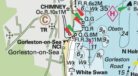
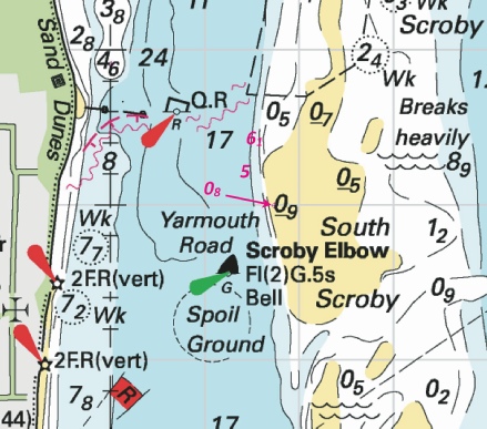
Affects: UKHO SNC: 1534 (INT 1558) (Panel A, Great Yarmouth Outer Harbour), 1534 (INT 1558) (Panel B, Great Yarmouth Haven), 1534 and 1535. UKHO SCC: 5614.4 (Panel B, Great Yarmouth Outer Harbour), 5614.5 (Panel B, Great Yarmouth Haven), 5614.4 (Panel A, Approaches to Great Yarmouth) and 5614.5 (Panel A, Northern Approaches to Great Yarmouth) Imray Full Charts: C28C Four revised depths at Great Yarmouth; one just inside the northern haven entrance, a second outside the southern haven mole, one revised depth in the River yare (which is good for us) and finally a slight reduction off the Spending Beach in the River Yare. Unlikely to hinder leisure craft.
|
|
Week 18 |
New Editions of ADMIRALTY Charts to be published 15th May, 2025 SN Chart 1504 - |
|
|
Week 13 |
ENGLAND - Submarine cable laying works are taking place between East Anglia Three Offshore Wind Farm and a site NE of Felixstowe, along a line joining the following positions: 52° 00´·02N., 1° 25´·40E. 51° 59´·62N., 1° 26´·45E. 52° 00´·39N., 1° 31´·01E. 52° 04´·18N., 1° 37´·24E. 52° 05´·33N., 1° 43´·47E. 52° 07´·88N., 1° 49´·56E. 52° 13´·38N., 2° 18´·29E. 52° 13´·70N., 2° 26´·10E. 52° 17´·77N., 2° 26´·96E. 52° 20´·82N., 2° 30´·40E. 52° 20´·88N., 2° 34´·48E. 52° 27´·14N., 2° 35´·84E. 52° 27´·62N., 2° 44´·99E. 52° 38´·93N., 2° 45´·08E. 52° 40´·24N., 2° 51´·74E. Charts will be updated when works are complete. Mariners are advised to navigate with caution in the area. Notice 1353(P) refers Base image is from UKHO SN chart 1408. © Crown Copyright and/or database rights. Reproduced by permission of The Keeper of Public Records and the UK Hydrographic Office (www.GOV.uk/UKHO).
|
Affects: UKHO SNC: 1406, 1408, 1504, 1543, 1610, 1630, 1631, 2052, 2182A and 2693. UKHO SCC: 5607.5, 5614.1 and 5614.25. Imray Full Charts: C30 Imray Leisure Folios: 2110.2 This preliminary notice advertises the route for the power cable out from just NE of the Deben to the East Anglia Three Offshore Wind Farm. This is associated with the following preliminary notice of the marking of the Wind Farm perimeter. The Image illustrates the route and the location and general marking of the Wind Farm. The following notice shows the detail and characteristics of WF marking.
|
|
Week 13 |
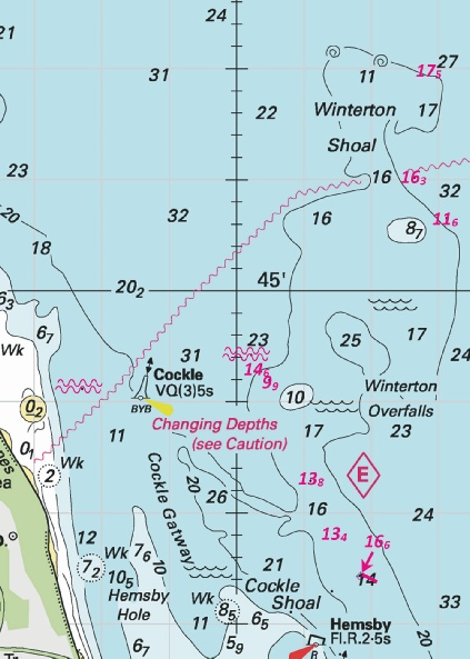
ENGLAND - *Construction of the East Anglia Three Offshore Wind Farm is taking place in the vicinity of position 52° 40´·24N., 2° 51´·74E. The main Wind Farm Array work area is marked by light- Buoy Type Characteristic Position West Cardinal Q(9)15s 52° 31´·81N., 2° 45´·15E. Special Mark Fl.Y.5s 52° 34´·64N., 2° 44´·90E. West Cardinal VQ(9)10s 52° 37´·47N., 2° 44´·87E. Special Mark Fl.Y.5s 52° 40´·30N., 2° 44´·85E. West Cardinal Q(9)15s 52° 43´·12N., 2° 45´·09E. Special Mark Fl.Y.5s 52° 44´·64N., 2° 47´·48E. North Cardinal Q 52° 45´·50N., 2° 50´·96E. Special Mark Fl.Y.5s 52° 45´·71N., 2° 55´·56E. North Cardinal VQ 52° 45´·92N., 3° 00´·15E. East Cardinal Q(3)10s 52° 43´·69N., 3° 00´·75E. Special Mark Fl.Y.5s 52° 40´·79N., 2° 59´·02E. East Cardinal VQ(3)5s 52° 38´·17N., 2° 56´·53E. Special Mark Fl.Y.5s 52° 35´·54N., 2° 54´·04E. East Cardinal Q(3)10s 52° 32´·92N., 2° 51´·56E. South Cardinal VQ(6)+LFl.10s 52° 31´·15N., 2° 48´·25E. All vessels should navigate with caution in the area. A safety zone of 500 metres becomes operational around the turbines under construction. *Former Notice 4802(P)/24 is cancelled. *Indicates new or revised entry Notice 1354(P) refers Base image is from Imray chart C2110.2 by courtesy of Imray and Meridian Chartware.
|
Affects: UKHO SNC: 1504 *These changes will be included in a New Edition of Chart 1504 to be published mid 2025. *Charts 1408, 1631, 2182A and 5614_25 will be updated by Notice to Mariners. This preliminary notice repeats Notice 4802(P) of 2024 which announces the new buoyage marking out the construction area for the East Anglia Three Offshore Wind Farm which will commence later this year. The area is outside of the area which I monitor but I have provided images showing ‘context’ and the buoy ‘map’. While under construction 500m safety zones (aka exclusion zones) will be placed around turbines sites. The power lines are intended to come ashore about 1.4nm north of the Deben at Bawdsey. Subsequent notices will report when the buoys have been placed.
|
|
Week 7 |
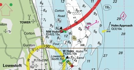
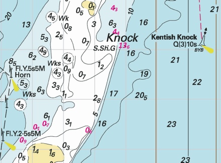
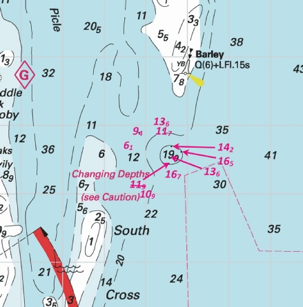
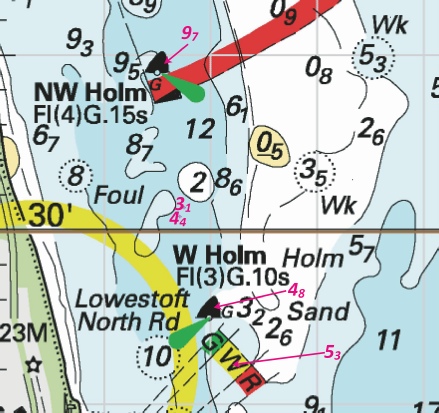
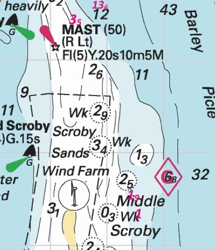
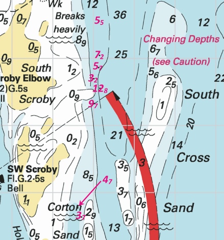
705(P)/2025 ENGLAND - Source: mv Northern Wind and Trinity House (SEP: 2025000034905 - 1. Recent survey information has shown that depths less than charted exist within the vicinity of Lowestoft and Approaches. The most significant are as follows: Depth Position 6·5m 52° 32´·32N., 1° 49´·03E. 9·4m 52° 30´·22N., 1° 49´·76E. 9·4m 52° 32´·95N., 1° 48´·69E. 9·4m 52° 32´·29N., 1° 49´·15E. 9·4m 52° 33´·63N., 1° 47´·73E. 4·4m 52° 28´·332N., 1° 45´·729E. 1·4m 52° 28´·270N., 1° 45´·681E. 1·2m 52° 27´·86N., 1° 45´·17E. 0·7m 52° 27´·74N., 1° 45´·03E. 1·4m 52° 27´·12N., 1° 44´·80E. 0·8m 52° 26´·59N., 1° 44´·79E. 4·4m 52° 26´·77N., 1° 46´·61E. 1·4m 52° 25´·34N., 1° 44´·98E. 5·0m 52° 38´·01N., 1° 49´·52E. 10m 52° 38´·61N., 1° 49´·45E. 10m 52° 37´·38N., 1° 49´·42E. 30m 52° 37´·79N., 1° 49´·64E. 8·3m 52° 42´·03N., 1° 45´·80E. 13·9m 52° 41´·49N., 1° 46´·77E. 3·6m 52° 40´·73N., 1° 44´·52E. 0·8m 52° 40´·31N., 1° 44´·60E. 4·2m 52° 41´·30N., 1° 44´·88E. 1·5m 52° 37´·78N., 1° 48´·99E. 18·7m 52° 39´·03N., 1° 49´·32E. 28·9m 52° 39´·58N., 1° 49´·46E. 9·4m 52° 39´·80N., 1° 48´·43E. 14·7m 52° 40´·54N., 1° 48´·25E. 7·0m 52° 42´·33N., 1° 43´·83E. 6·9m 52° 41´·90N., 1° 43´·88E. 4·2m 52° 41´·19N., 1° 44´·55E. 4·8m 52° 38´·01N., 1° 45´·03E. * 3·6m 52° 26´·54N., 1° 47´·24E. Mariners are advised to navigate with caution in the area. Charts will be updated when full details are available. *Former Notice 448(P)/25 is cancelled. * Indicates new or revised entry Notice 705(P) refers Base image is from Imray chart C28 by courtesy of Imray and Meridian Chartware.
|
Affects: UKHO SNC: 106, 1534, 1535 and 1543. UKHO SCC: 5614.1, 5614.2, 5614.3, 5614.4, 5614.5 and 5614.6 Imray Full Charts: C28 This is a Preliminary Notice which is part of a series of seven other Preliminary Notices published in the second part of 2024 and one earlier this year. The series has published 36 reductions of depths from Winterton Ness and Kessingland. This Notice is adding four reductions of depth from Hemsby Hole to just north of Great Yarmouth. As such the new reductions should not hinder leisure craft. The notices in in 2025 is 448(P) and 2024 are: 4389(P), 4628(P), 4900(P), 5001(P), 5018(P), 5069(P) and 5165(P). You can access the images for those in the 2024 list. This notice has one reduction of depth right in the middle between the Newcome Sand PHB and the S. Holm SCB (i.e. the Stanford Channel south entrance). At 3.6m there is significant water for leisure craft but the entrance continues to reduce!
|
|
Week 6 |
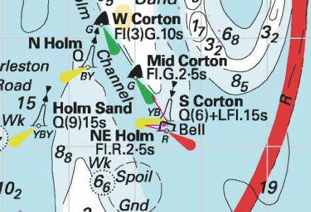
ENGLAND - Insert: depth, 4.6, and extend 5m contour NE to enclose 52° 32´·13N., 1° 48´·69E. Delete depth, 5.2, close SW. depth, 4.9, and extend 5m contour NE to enclose 52° 31´·87N., 1° 48´·99E. Delete depth, 6.1, close NE Notice 609 refers Base image is from Imray chart C28 by courtesy of Imray and Meridian Chartware.
|
Affects: UKHO SNC: 1534, 1535 and 1543. UKHO SCC: 5614.3, 5614.4 (Panel A, Approaches to Great Yarmouth) and 5614.2 Imray Full Charts: C28 Two reductions of depth on the approach to the south entrance of the Holm Channel towards Great Yarmouth. Unlikely to hinder leisure craft. There were quite a few reductions of depth in the approaches to the Holm Channel and in the Corton Road during 2024, viz: NtM 1641, 2943, 3111, 4389(P) and 5473 of 2024 in the Approachs and 2873 and 3008 of 2024 in the Corton Road. You can see those images in the 2024 list on the webpage.
|
|
Week 5 |
ENGLAND - Recent survey information has shown that depths less than charted exist within the vicinity of Lowestoft and Approaches. The most significant are as follows: Depth Position 6·5m 52° 32´·32N., 1° 49´·03E. 9·4m 52° 30´·22N., 1° 49´·76E. 9·4m 52° 32´·95N., 1° 48´·69E. 9·4m 52° 32´·29N., 1° 49´·15E. 9·4m 52° 33´·63N., 1° 47´·73E. 4·4m 52° 28´·332N., 1° 45´·729E. 1·4m 52° 28´·270N., 1° 45´·681E. 1·2m 52° 27´·86N., 1° 45´·17E. 0·7m 52° 27´·74N., 1° 45´·03E. 1·4m 52° 27´·12N., 1° 44´·80E. 0·8m 52° 26´·59N., 1° 44´·79E. 4·4m 52° 26´·77N., 1° 46´·61E. 3·8m 52° 26´·53N., 1° 47´·22E. 1·4m 52° 25´·34N., 1° 44´·98E. 5·0m 52° 38´·01N., 1° 49´·52E. 10m 52° 38´·61N., 1° 49´·45E. 10m 52° 37´·38N., 1° 49´·42E. 30m 52° 37´·79N., 1° 49´·64E. 8·3m 52° 42´·03N., 1° 45´·80E. 13·9m 52° 41´·49N., 1° 46´·77E. 3·6m 52° 40´·73N., 1° 44´·52E. 0·8m 52° 40´·31N., 1° 44´·60E. 4·2m 52° 41´·30N., 1° 44´·88E. 1·5m 52° 37´·78N., 1° 48´·99E. 18·7m 52° 39´·03N., 1° 49´·32E. 28·9m 52° 39´·58N., 1° 49´·46E. 9·4m 52° 39´·80N., 1° 48´·43E. 14·7m 52° 40´·54N., 1° 48´·25E. * 7·0m 52° 42´·33N., 1° 43´·83E. * 6·9m 52° 41´·90N., 1° 43´·88E. * 4·2m 52° 41´·19N., 1° 44´·55E. * 4·8m 52° 38´·01N., 1° 45´·03E. Mariners are advised to navigate with caution in the area. Charts will be updated when full details are available. Former Notice 5165(P)/24 is cancelled. * Indicates new or revised entry Notice 448(P) refers Base image is from Imray chart C28 by courtesy of Imray and Meridian Chartware.
|
Affects: UKHO SNC: 106, 1534, 1535 and 1543. UKHO SCC: 5614.1, 5614.2, 5614.3, 5614.4, 5614.5 and 5614.6 Imray Full Charts: C28 This is a Preliminary Notice which is part of a series of seven other Preliminary Notices published in the second part of 2024. The series has published 33 reductions of depths from Winterton Ness and Kessingland. This Notice is adding four reductions of depth from Hemsby Hole to just north of Great Yarmouth. As such the new reductions should not hinder leisure craft. The notices in 2024 are: 4389(P), 4628(P), 4900(P), 5001(P), 5018(P), 5069(P) and 5165(P). You can access the images for those in the 2024 list.
|
|
Week 5 |
EAST COAST OF ENGLAND - Latitude 52° 55.482’N., Longitude 001° 18.990’E. Amendment: The nominal range of the main light has been permanently reduced to 18 nautical miles. The light characteristic remains unaltered but with a revised composition of fl 1.0s, ec 4.0s. Trinity House Notice to Mariners 14/2023, dated 27th April 2023, is hereby cancelled. Trinity House Notice to Mariners 2 of 2025 refers
|
Affects: UKHO SNC: 106, 1503 and 1504. Imray Full Charts: C28 Notice from Trinity House reported permanent changes in the light characteristic of the Cromer Lighthouse. No image considered necessary. |
|
SCROLL DOWN FOR 2024 NOTICES |
||
|
Week 52 |
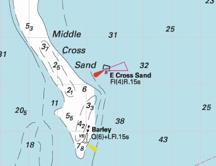
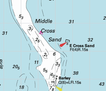
EAST COAST OF ENGLAND - Amendment: Moved to new assigned position: Latitude 52˚ 40.293’N., Longitude 001˚ 53.737’E. No further notice will be given. Trinity House No 30 of 2024 refers The base image courtesy of Imray Chart C28 and Meridian Chartware.
|
Affects: UKHO SNC: 1534, 1535 and 1543. UKHO SCC: 5614.1, 5614.2, 5614.3, 5614.4 and 5614.5. Imray Full Charts: C28 Trinity House has reported today that the East Cross lighted buoy marking the eastern side of the Middle Cross Sand has been moved. The extent of the move is quite small so difficult (but not impossible) to illustrate!
|
|
Week 50 |
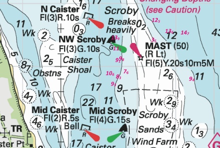
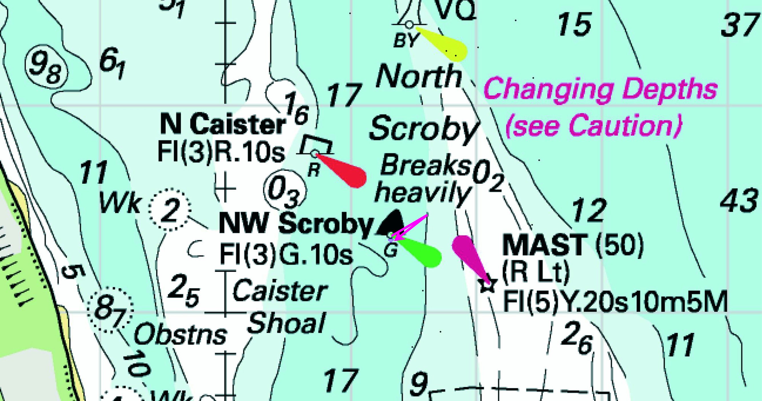
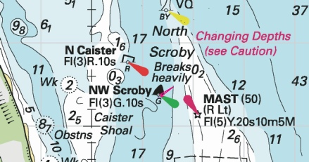
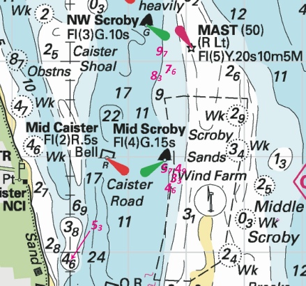
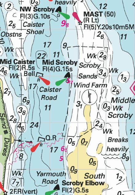
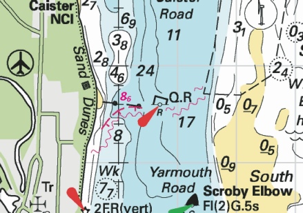
ENGLAND - Insert: depth, 9.3, and extend 10m approximate contour W to enclose 52° 39´·71N., 1° 46´·38E. depth, 10.6, and extend 15m contour W to enclose 52° 39´·89N., 1° 46´·31E. Delete depth, 16.1, close SW. depth, 9.1, and extend 10m approximate contour NW to enclose 52° 40´·09N., 1° 46´·53E. Delete depth, 10.8, close N. depth, 11.1 at 52° 40´·28N., 1° 46´·49E. Delete depth, 13.4, close NW. depth, 13.9, and extend 15m approximate contour NW to enclose 52° 40´·44N., 1° 46´·43E. Delete depth, 16.8, close NW. Notice 5664 refers The base image courtesy of Imray Chart C28 and Meridian Chartware.
|
Affects: UKHO SNC: 1534 and 1543. UKHO SCC: 5614.5 (Panel A, Northern Approaches to Great Yarmouth), 5614.2 and 5614.6 (Panel A, Caister- Imray Full Charts: C28 Five new reduced depths in the Caister Road between the NW and Mid Scroby SHBs. The depths are unlikely to hinder leisure craft. The image includes changes reported in 4 previous permanent Notices and one preliminary Notice this year.
|
|
Week 50 |
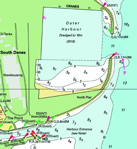
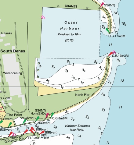
ENGLAND - Insert: depth, 9, and extend 10m contour E to enclose 52° 34´·613N., 1° 44´·801E. Notice 5711 refers The base image courtesy of Imray Chart C28C and Meridian Chartware.
|
Affects: UKHO SNC: 1534 (Panel A, Great Yarmouth Outer Harbour). UKHO SCC: 5614.4(Panel B, Great Yarmouth Outer Harbour). Imray Full Charts: C28C A revised depth at the south entrance of the Great Yarmouth outer harbour. Ample water for a leisure craft and not where we ought to be. The image includes revised depths from NtM 2873 earlier this year.
|
|
Week 49 |
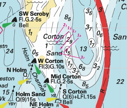
ENGLAND - Insert: depth, 6.5 at 52° 32´·70N., 1° 48´·55E. Delete depth, 7.3, close S and depth 7.6 close NW. depth, 5.8 at 52° 32´·49N., 1° 48´·74E. Delete depth, 6.9, close N. depth, 4.7, enclosed by 5m contour at 52° 32´·33N., 1° 48´·80E. Delete depth, 6.6, close NE, depth, 5.3, close S and depth, 6.9, close NW. Notice 5473 refers The base image courtesy of Imray Chart C28 and Meridian Chartware.
|
Affects: UKHO SNC: 1534, 1535 and 1543. UKHO SCC: 5614.3, 5614.4 (Panel A, Approaches to Great Yarmouth and 5614.2. Imray Full Charts: C28 Continued changes in the southern entrance of the Holm Channel (to Great Yarmouth). Three reduced depths there but ample water for leisure craft. The chartlet includes previous changes this year including the moves of the S. Corton cardinal and NE Holm PH buoys.
|
|
Week 48 |
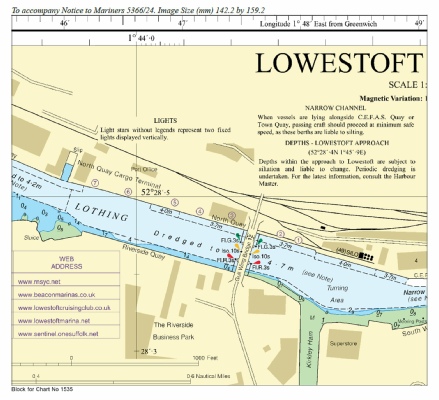
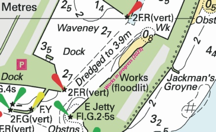
ENGLAND - Insert: the accompanying block, centred on: 52° 28´·5N., 1° 44´·2E. Notice 5366 refers Block is copyright of the UKHO.
|
Affects: UKHO SNC: 1535 Imray Full Charts: C28 Imray Leisure Folios 2000.10 A further Block from UKHO for the area of the Gull Wing Bridge in Lowestoft. Notice 5232 in week 46 provided two blocks in the same area, one for the Panel in the SNC and the other for the SCC. This block is the block for the main part of the SNC (i.e. good scale!).
|
|
Week 47 |
ENGLAND - Insert: depth, 9.2 at 52° 34´·20N., 1° 45´·06E. Delete depth, 9.7, close E. Notice 5347 refers The base image courtesy of Imray Chart C28 and Meridian Chartware.
|
Affects: UKHO SNC: 1534 and 1535. UKHO SCC: 5614.3 and 5614.4 (Panel A, Approaches to Great Yarmouth). Imray Full Charts: C28 One reduction of depth on the southeast approaches to Great Yarmouth. Unlikely to hinder leisure craft.
|
|
Week 46 |
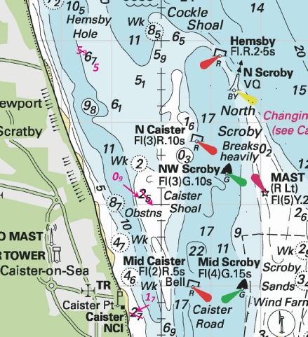
ENGLAND - Recent survey information has shown that depths less than charted exist within the vicinity of Lowestoft and Approaches. The most significant are as follows: Depth Position 6·5m 52° 32´·32N., 1° 49´·03E. 9·4m 52° 30´·22N., 1° 49´·76E. 9·4m 52° 32´·95N., 1° 48´·69E. 9·4m 52° 32´·29N., 1° 49´·15E. 9·4m 52° 33´·63N., 1° 47´·73E. 4·4m 52° 28´·332N., 1° 45´·729E. 1·4m 52° 28´·270N., 1° 45´·681E. 1·2m 52° 27´·86N., 1° 45´·17E. 0·7m 52° 27´·74N., 1° 45´·03E. 1·4m 52° 27´·12N., 1° 44´·80E. 0·8m 52° 26´·59N., 1° 44´·79E. 4·4m 52° 26´·77N., 1° 46´·61E. 3·8m 52° 26´·53N., 1° 47´·22E. 1·4m 52° 25´·34N., 1° 44´·98E. 5·0m 52° 38´·01N., 1° 49´·52E. 10m 52° 38´·61N., 1° 49´·45E. 10m 52° 37´·38N., 1° 49´·42E. 30m 52° 37´·79N., 1° 49´·64E. 8·3m 52° 42´·03N., 1° 45´·80E. 13·9m 52° 41´·49N., 1° 46´·77E. 3·6m 52° 40´·73N., 1° 44´·52E. 0·8m 52° 40´·31N., 1° 44´·60E. 4·2m 52° 41´·30N., 1° 44´·88E. * 1·5m 52° 37´·78N., 1° 48´·99E. * 18·7m 52° 39´·03N., 1° 49´·32E. * 28·9m 52° 39´·58N., 1° 49´·46E. * 9·4m 52° 39´·80N., 1° 48´·43E. * 14·7m 52° 40´·54N., 1° 48´·25E. Mariners are advised to navigate with caution in the area. Charts will be updated when full details are available. Former Notice 5069(P)/24 is cancelled. * Indicates new or revised entry (ETRS89 DATUM) Notice 5165(P) refers The base image courtesy of Imray Chart C28 and Meridian Chartware.
|
Affects: UKHO SNC: 1534, 1535 and 1543. UKHO SCC: 5614.1, 5614.2, 5614.3, 5614.4, 5614.5 and 5614.6. Imray Full Charts: C28 This preliminary Notice is a continuation of the (almost weekly) series of preliminary notices advising reduced depths from Winterton Ness to Benacre Ness. This notice adds 5 further reduced depths on the eastern side of the Scroby sands. The image should be seen in conjunction with the image of last week vide NtM 5069(P).
|
|
Week 46 |
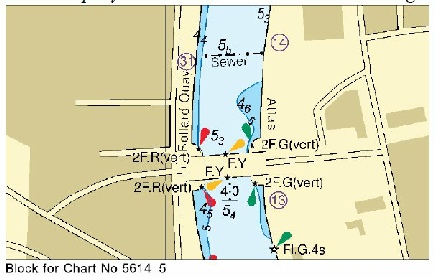
ENGLAND - Insert: the accompanying block, centred on: 52° 28´·5N., 1° 44´·1E. Notice 5232 refers The block is copyright of UKHO.
|
Affects: UKHO SNC: 1535 (Panel, Lowestoft Harbour) UKHO SCC: 5614.20 (Panel A, Lowestoft Harbour). Imray Full Charts: C28 Imray Leisure Folios 2000.10 The UKHO has issued two UKHO block covering the area of the Lowestoft Inner Harbour showing the new Gull Wing Bridge; one for the SNC and one for the relevant SCC.
|
|
Week 45 |
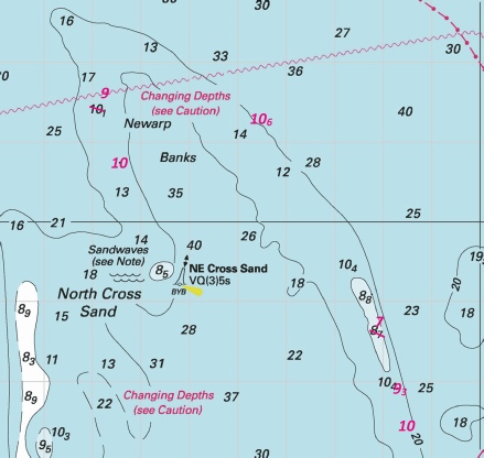
ENGLAND - Recent survey information has shown that depths less than charted exist within the vicinity of Lowestoft and Approaches. The most significant are as follows: Depth Position 6·5m 52° 32´·32N., 1° 49´·03E. 9·4m 52° 30´·22N., 1° 49´·76E. 9·4m 52° 32´·95N., 1° 48´·69E. 9·4m 52° 32´·29N., 1° 49´·15E. 9·4m 52° 33´·63N., 1° 47´·73E. 4·4m 52° 28´·332N., 1° 45´·729E. 1·4m 52° 28´·270N., 1° 45´·681E. 1·2m 52° 27´·86N., 1° 45´·17E. 0·7m 52° 27´·74N., 1° 45´·03E. 1·4m 52° 27´·12N., 1° 44´·80E. 0·8m 52° 26´·59N., 1° 44´·79E. 4·4m 52° 26´·77N., 1° 46´·61E. 3·8m 52° 26´·53N., 1° 47´·22E. 1·4m 52° 25´·34N., 1° 44´·98E. 5·0m 52° 38´·01N., 1° 49´·52E. 10m 52° 38´·61N., 1° 49´·45E. 10m 52° 37´·38N., 1° 49´·42E. 30m 52° 37´·79N., 1° 49´·64E. 8·3m 52° 42´·03N., 1° 45´·80E. 13·9m 52° 41´·49N., 1° 46´·77E. * 3·6m 52° 40´·73N., 1° 44´·52E. * 0·8m 52° 40´·31N., 1° 44´·60E. * 4·2m 52° 41´·30N., 1° 44´·88E. Mariners are advised to navigate with caution in the area. Charts will be updated when full details are available. Former notice 5018(P)/24 is cancelled. * Indicates new or revised entry. Notice 5069(P) refers The base image courtesy of Imray Chart C28 and Meridian Chartware.
|
Affects: UKHO SNC: 1534, 1535 and 1543. UKHO SCC: 5614.1, 5614.2, 5614.3, 5614.4, 5614.5 and 5614.6. Imray Full Charts: C28 This preliminary Notice is a continuation of the series of preliminary notices advising reduced depths from Winterton Ness to Benacre Ness. This notice adds 3 reduced depths at the Hemsby Hole and North Caister. The images includes all other reduced depths in the area reported this year.
|
|
Week 45 |
ENGLAND - Insert:
Move:
Delete: former Notice 5080 refers The base image courtesy of Imray Chart C28 and Meridian Chartware.
|
Affects: UKHO SNC: 1535 and 1543. UKHO SCC: 5614.1 (Panel A, Orford Ness to Benacre Ness), 5614.2 and 5614.3. Imray Full Charts: C28 This permanent notice is confirming buoy moves reported earlier by Trinity House (TH21 of 2024). The moves affected were the SW Holm SHB, South Holm SCB, Newcome Sand PHB and the Stanford PHB.
|
|
Week 44 |
ENGLAND - Recent survey information has shown that depths less than charted exist within the vicinity of Lowestoft and Approaches. The most significant are as follows: Depth Position 6·5m 52° 32´·32N., 1° 49´·03E. 9·4m 52° 30´·22N., 1° 49´·76E. 9·4m 52° 32´·95N., 1° 48´·69E. 9·4m 52° 32´·29N., 1° 49´·15E. 9·4m 52° 33´·63N., 1° 47´·73E. 4·4m 52° 28´·332N., 1° 45´·729E. 1·4m 52° 28´·270N., 1° 45´·681E. 1·2m 52° 27´·86N., 1° 45´·17E. 0·7m 52° 27´·74N., 1° 45´·03E. 1·4m 52° 27´·12N., 1° 44´·80E. 0·8m 52° 26´·59N., 1° 44´·79E. 4·4m 52° 26´·77N., 1° 46´·61E. * 3·8m 52° 26´·53N., 1° 47´·22E. 1·4m 52° 25´·34N., 1° 44´·98E. 5·0m 52° 38´·01N., 1° 49´·52E. 10m 52° 38´·61N., 1° 49´·45E. 10m 52° 37´·38N., 1° 49´·42E. 30m 52° 37´·79N., 1° 49´·64E. * 8.3m 52° 42´·03N., 1° 45´·80E. * 13.9m 52° 41´·49N., 1° 46´·77E. Mariners are advised to navigate with caution in the area. Charts will be updated when full details are available. Former notice 5001(P)/24 is cancelled. * Indicates new or revised entry. Notice 5018(P) refers The base image courtesy of Imray ID10 Chart C28 and Meridian Chartware.
|
Affects: UKHO SNC: 1534, 1535 and 1543. UKHO SCC: 5614.1, 5614.2, 5614.3, 5614.4 and 5614.5. Imray Full Charts: C28 This preliminary Notice is one of a series of such notices advising of new reductions of depth down the coast from Winterton Ness to Benacre Ness. The notice is adding three new reductions of depth, one at the Newcombe Sand PHB and two around the North Scroby Sands. The first image at the Newcombe Sand includes the movement of the Newcombe Sand and South Holm SCB reported by Trinity House (TH No 21) and new overfalls adjacent reported by NtM 1190 earlier this year. The second image at the North Scroby includes previous reductions of depth by NtM 1974 and 3513 this year.
|
|
Week 43 |
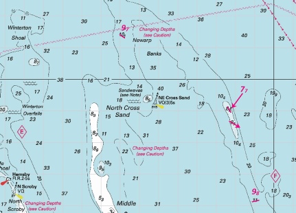
ENGLAND - Construction of the East Anglia Three Offshore Wind Farm will commence late 2024. The main Wind Farm Array work area will be marked by light- Buoy Type Characteristic Position West Cardinal Q(9)15s 52° 31´·81N., 2° 45´·15E. Special Mark Fl.Y.5s 52° 34´·64N., 2° 44´·90E. West Cardinal VQ(9)10s 52° 37´·47N., 2° 44´·87E. Special Mark Fl.Y.5s 52° 40´·30N., 2° 44´·85E. West Cardinal Q(9)15s 52° 43´·12N., 2° 45´·09E. Special Mark Fl.Y.5s 52° 44´·64N., 2° 47´·48E. North Cardinal Q 52° 45´·50N., 2° 50´·96E. Special Mark Fl.Y.5s 52° 45´·71N., 2° 55´·56E. North Cardinal VQ 52° 45´·92N., 3° 00´·15E. East Cardinal Q(3)10s 52° 43´·69N., 3° 00´·75E. Special Mark Fl.Y.5s 52° 40´·79N., 2° 59´·02E. East Cardinal VQ(3)5s 52° 38´·17N., 2° 56´·53E. Special Mark Fl.Y.5s 52° 35´·54N., 2° 54´·04E. East Cardinal Q(3)10s 52° 32´·92N., 2° 51´·56E. South Cardinal VQ(6)+LFL.10s 52° 31´·15N., 2° 48´·25E. All vessels should navigate with caution in the area. A safety zone of 500 metres becomes operational around the turbines under construction. Cable laying operations will be conducted between the new wind farm and a site NE of Felixstowe 51° 59´·97N., 1° 25´·33E. Charts will be updated when full details are available. Notice 4802(P) refers NORTH SEA - Insert Fl(5)Y.20s at:
52° 32´·88N., 2° 46´·96E. 52° 44´·82N., 2° 58´·45E. Notice 4941 refers The base image courtesy of Imray ID10 Chart IN1 and Meridian Chartware.
|
Affects: UKHO SNC: 1408, 1504, 1631 and 2182A. UKHO SCC: 5614.25 This preliminary notice announces the new buoyage marking out the construction area for the East Anglia Three Offshore Wind Farm which will commence later this year. The area is outside of the area which I monitor but I have provided images showing ‘context’ and the buoy ‘map’. While under construction 500m safety zones (aka exclusion zones) will be placed around turbines sites. The power lines are intended to come ashore about 1.4nm north of the Deben at Bawdsey. Subsequent notices will report when the buoys have been placed. In addition this week there is a second Notice (below) which places two yellow special lit buoys within the defined area. This is a permanent notice so those two buoys have now been placed.
|
|
Week 43 |
ENGLAND - Recent survey information has shown that depths less than charted exist within the vicinity of Lowestoft and Approaches. The most significant are as follows: Depth Position 6·5m 52° 32´·32N., 1° 49´·03E. 9·4m 52° 30´·22N., 1° 49´·76E. 9·4m 52° 32´·95N., 1° 48´·69E. 9·4m 52° 32´·29N., 1° 49´·15E. 9·4m 52° 33´·63N., 1° 47´·73E. 4·4m 52° 28´·332N., 1° 45´·729E. 1·4m 52° 28´·270N., 1° 45´·681E. 1·2m 52° 27´·86N., 1° 45´·17E. 0·7m 52° 27´·74N., 1° 45´·03E. 1·4m 52° 27´·12N., 1° 44´·80E. 0·8m 52° 26´·59N., 1° 44´·79E. 4·4m 52° 26´·77N., 1° 46´·61E. 4·4m 52° 26´·53N., 1° 47´·22E. 1·4m 52° 25´·34N., 1° 44´·98E. * 5·0m 52° 38´·01N., 1° 49´·52E. * 10m 52° 38´·61N., 1° 49´·45E. * 10m 52° 37´·38N., 1° 49´·42E. * 30m 52° 37´·79N., 1° 49´·64E. Mariners are advised to navigate with caution in the area. Charts will be updated when full details are available. Former notice 4628(P)/24 is cancelled. * Indicates new or revised entry. Notice 4900(P) refers The base image courtesy of Imray ID10 Chart C28 and Meridian Chartware.
|
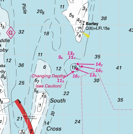
Affects: UKHO SNC: 1534, 1535 and 1543. UKHO SCC: 5614.1, 5614.2, 5614.3 and 5614.4. Imray Full Charts: C28 This preliminary Notice is one of a series of notices providing warning of reductions of depth in the vicinity of Lowestoft and its Approaches. This Notice has 4 new reductions of depth in the south end of Barley Picle (the channel between the Scroby and South Cross Sands. The reduced depths would not hinder leisure craft but nevertheless are dramatic; i.e. from generally over 30m down to 5 metres. In addition to the previous preliminary notice 4628(P), there have been two earlier Notices in that area (Nos 1974 and 2639) so the image includes those reductions (but in blue).
|
|
Week 41 |
ENGLAND - Recent survey information has shown that depths less than charted exist within the vicinity of Lowestoft and Approaches. The most significant are as follows: Depth Position 6·5m 52° 32´·32N., 1° 49´·03E. 9·4m 52° 30´·22N., 1° 49´·76E. 9·4m 52° 32´·95N., 1° 48´·69E. 9·4m 52° 32´·29N., 1° 49´·15E. 9·4m 52° 33´·63N., 1° 47´·73E. * 4·4m 52° 28´·332N., 1° 45´·729E. * 1·4m 52° 28´·270N., 1° 45´·681E. * 1·2m 52° 27´·86N., 1° 45´·17E. * 0·7m 52° 27´·74N., 1° 45´·03E. * 1·4m 52° 27´·12N., 1° 44´·80E. * 0·8m 52° 26´·59N., 1° 44´·79E. * 4·4m 52° 26´·77N., 1° 46´·61E. * 4·4m 52° 26´·53N., 1° 47´·22E. * 1·4m 52° 25´·34N., 1° 44´·98E. Mariners are advised to navigate with caution in the area. Charts will be updated when full details are available. Former Notice 4389(P)/24 is cancelled. Notice 4628(P) refers The base image courtesy of Imray ID10 Chart C28 and C28D and Meridian Chartware.
|
Affects: UKHO SNC: 1534, 1535 and 1543. UKHO SCC: 5614.1, 5614.2, 5614.3 and 5614.4. Imray Full Charts: C28 A preliminary notice adding 9 reduced depths in the vicinity of Lowestoft and the Approaches to 5 reduced depths further north in preliminary NtM 4389(P)/24. The reductions affect the top end and eastern side of the Newcombe Sands, the Lowestoft South Road and the Barnard. I would suggest if using the Barnard and Lowestoft South Road the Notice is essential reading. See image in conjunction with NtM 4389(P) in week 39.
|
|
Week 40 |
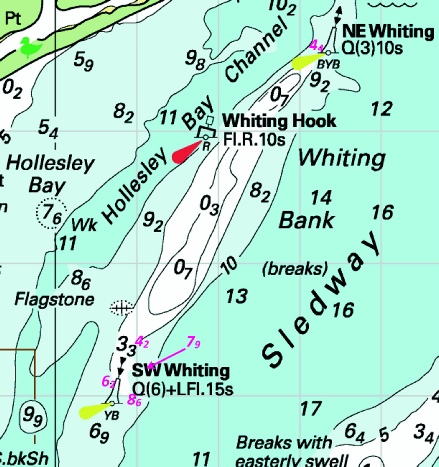
ENGLAND - Insert: depth, 6.2 at 52° 01´·09N., 1° 30´·68E. Delete depth, 6.9, close NE. depth, 8.6, and extend 10m contour SE to enclose 52° 00´·98N., 1° 30´·98E. Delete depth, 9.1, close N. depth, 7.9 at 52° 01´·23N., 1° 31´·07E. Delete depth, 8.7, close N. depth, 4.2, and extend 5m contour S to enclose 52° 01´·40N., 1° 31´·05E. Delete depth, 5.7, close W. depth, 4.4, and extend 5m contour NE to enclose 52° 03´·63N., 1° 33´·26E. Delete depth, 6.8, close NE. Notice 4455 refers The base image courtesy of Imray ID10 Chart C1 and Meridian Chartware.
|
Affects: UKHO SNC: 2052 and 2693. UKHO SCC: 5607.5 and 5614.1 (Panel B, Orford Ness). Imray Full Charts: C1, C28 Imray Leisure Folios 2000.1 5 reductions of depth on the Whiting Bank off Orford Haven. 4 around the SW Whiting SCB and one by the NE Whiting NCB.
|
|
Week 39 |
ENGLAND - Recent survey information has shown that depths less than charted exist within the vicinity of Lowestoft and Approaches. The most significant are as follows: Depth Position 6·5m 52° 32´·32N., 1° 49´·03E. 9·4m 52° 30´·22N., 1° 49´·76E. 9·4m 52° 32´·95N., 1° 48´·69E. 9·4m 52° 32´·29N., 1° 49´·15E. 9·4m 52° 33´·63N., 1° 47´·73E. Mariners are advised to navigate with caution in the area. Notice 4389(P) refers The base image courtesy of Imray ID10 Chart C28 and Meridian Chartware.
|
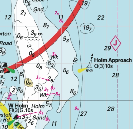
Affects: UKHO SNC: 1584, 1535 and 1543. UKHO SCC: 5614.2 and 5614.4. Imray Full Charts: C28 A preliminary notice advising of 5 reductions of depth in Holm Approaches to Lowestoft. The depths should not hinder leisure craft.
|
|
Week 39 |
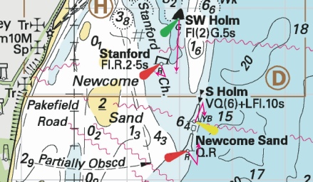
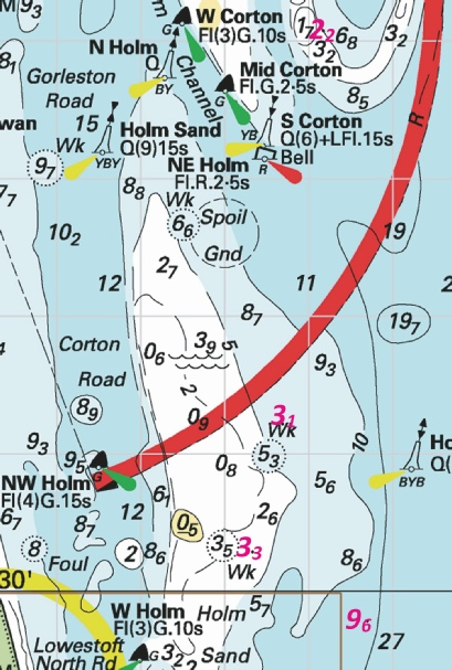
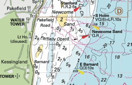
EAST COAST OF ENGLAND - South West Holm Lighted Buoy Moved to new assigned position: Latitude 52˚ 27.243’N, Longitude 001˚ 46.940’E. South Holm Lighted Buoy Moved to new assigned position: Latitude 52˚ 26.720’N, Longitude 001˚ 47.470’E. Stanford Lighted Buoy Moved to new assigned position: Latitude 52˚ 27.260’N, Longitude 001˚ 46.530’E. Newcome Sand Lighted Buoy Moved to new assigned position: Latitude 52˚ 26.425’N, Longitude 001˚ 47.367’E. Movement effected consequent upon a recent survey. Trinity House NtM No 21 of 2024 refers The base image courtesy of Imray ID10 Chart C28 and Meridian Chartware.
|
Affects: UKHO SNC: 1584, 1535 and 1543. UKHO SCC: 5614.1 and 5614.2. Imray Full Charts: C28 A Trinity House NtM advising that the buoyage in the Stanford Channel has had four significant moves involving the SW and S Holm buoys (SHB and SCB) and the Stanford and Newcombe Sand PHBs.
|
|
Week 38 |
New Editions of ADMIRALTY Small Craft Charts to be published on 3td October, 2024 SCC 5614.3 Approaches to Lowestoft. 1:25,000 SCC 5614.4 A Approaches to Great Yarmouth. 1:25,000 B Great Yarmouth, Outer Harbour. 1:7,500 SCC 5614.5 A Northern Approaches to Great Yarmouth. 1:25,000 B Great Yarmouth Haven. 1:7,500 |
Includes full updates for New Edition and Notices to Mariners affecting source charts. |
|
Week 37 |
ENGLAND - Insert: depth, 5.9 at 52° 41´·86N., 1° 43´·43E. Delete depth, 7.3, close N. depth, 5, enclosed by 5m contour at 52° 41´·67N., 1° 43´·67E. Delete depth, 6.3, close NW. depth, 0.9, enclosed by 2m approximate contour at 52° 40´·07N., 1° 44´·56E. Delete depth, 2, close NW. depth, 1.7, enclosed by 2m contour at 52° 38´·68N., 1° 44´·51E. Delete depth, 2.6, close N. Notice 4144 refers The base image courtesy of Imray ID10 Chart C28 and Meridian Chartware.
|
Affects: UKHO SNC: 1534 and 1543. UKHO SCC: 5614.5 (Panel A, Northern Approaches to Great Yarmouth), 5614.6 (Panel A, Caister- Imray Full Charts: C28 4 reductions of depth on the Caister Shoal off Hemsby.
|
|
Week 36 |
ENGLAND - Move:
to: 52° 33´·19N., 1° 48´·50E. Notice 4049 refers The base image courtesy of Imray ID10 Chart C28 and Meridian Chartware.
|
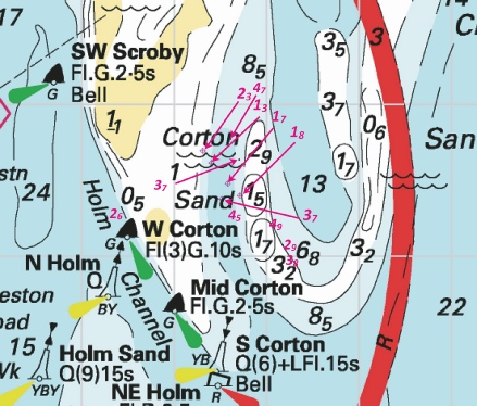
Affects: UKHO SNC: 1534 and 1535. UKHO SCC: 5614.3, 5614.4 (Panel A, Approaches to Great Yarmouth) and 5614.5 (Panel A, Northern Approaches to Great Yarmouth). Imray Full Charts: C28 This notice confirms Trinity House Notices Nos 14 and 15 reported in Week 31 this year notifying the moves of the NW Scroby SHB (very small move) and the S. Corton SCB and NE Holm PHB.
|
|
Week 35 |
New Editions of ADMIRALTY Charts to be published 29 August 2024 SNC 2695 England - A Walton Backwaters. 1:12,500 B Continuation of Landermere Creek. 1:12,500 C Rivers Ore and Alde. 1:25,000 D Southwold Harbour. 1:7,500 |
Includes changes to depths from the latest Harwich Haven Authority and Trinity House surveys. |
|
Week 33 |
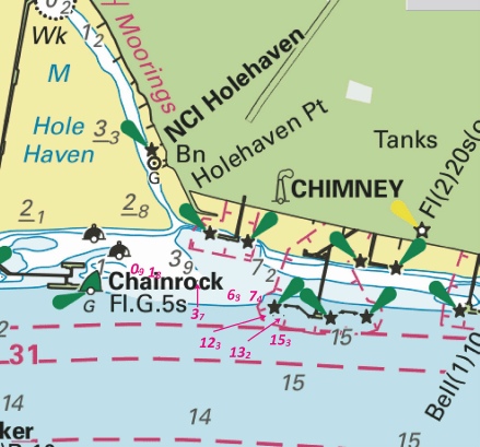
ENGLAND - Insert: depth, 0.8 at 51° 30´·47N., 0° 33´·03E. Delete depth, 0.9, close W. depth, 6.3 at 51° 30´·42N., 0° 33´·35E. Delete depth, 6.1, close W. depth, 15.3 at 51° 30´·334N., 0° 33´·497E. depth, 12.3 at 51° 30´·382N., 0° 33´·469E. depth, 7.4 at 51° 30´·415N., 0° 33´·417E. Delete depth, 8.2, close S. depth, 3.7 at 51° 30´·452N., 0° 33´·223E. Delete depth, 3.9, close W. depth, 1.8 at 51° 30´·469N., 0° 33´·076E. Delete depth, 2, close SW. depth, 7.8 at 51° 29´·485N., 0° 28´·247E. Delete 8.4, close NE. depth, 7.5 at 51° 29´·406N., 0° 28´·132E. Delete depth, 7.6, close S. Replace: depth, 14.1, with depth, 13.2 at 51° 30´·381N., 0° 33´·505E. Notice 3775 refers The base image courtesy of Imray ID10 Chart IN5036 and Meridian Chartware.
|
Affects: UKHO SNC: 1185 and 1186 (Panel A, Canvey Island to Coalhouse Point). UKHO SCC: 5606.8. Imray Full Charts: C2 Imray Leisure Folios 2100.2 and 2100.3 A total of 10 reductions of depth in the Yantlet Reach, two close to the Lower Hope PHB and 8 in and around the Chainrock jetties and the entrance into Hole Haven. The depths at the Lower Hope will not hinder leisure craft but around the entrance of Hole Haven has shoaling.
|
|
Week 31 |
ENGLAND - Insert: depth, 4.5, enclosed by 5m contour at 52° 34´·476N., 1° 44´·020E. depth, 3.9 at 52° 34´·540N., 1° 44´·016E. Delete depth, 4.4, close N. depth, 4.7, enclosed by 5m contour at 52° 34´·760N., 1° 43´·969E. Delete depth, 5.3, close W. depth, 4.3 at 52° 34´·819N., 1° 43´·953E. Delete depth, 4.9, close SE. depth, 1.3, enclosed by 2m contour at 52° 35´·735N., 1° 43´·630E. Replace: depth, 5, with depth, 4.4 at 52° 34´·865N., 1° 43´·930E. Notice 3579 refers Base image courtesy of Imray ID10 Chart C28C and Meridian Chartware.
|
Affects: UKHO SCC: 5614.4 (Panel B, Great Yarmouth Outer Harbour) and 5614.5 (Panel B, Great Yarmouth Haven) Imray Full Charts: C28C. 6 reductions of depth alongside the east jetties of the River Yare. All where we ought not to be!
|
|
Week 31 |
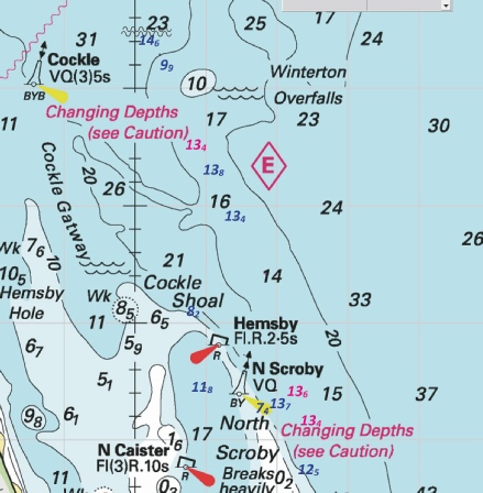
ENGLAND - Insert: depth, 0.6, and extend 2m contour E to enclose 51° 36´·39N., 1° 36´·82E. Delete depth, 1.6, close W. depth, 8.7, and extend 10m contour NW to enclose 51° 41´·99N., 1° 37´·87E. Delete depth, 7.3, close SE. depth, 3.5, and extend 5m contour NE to enclose 51° 42´·59N., 1° 38´·60E. Delete depth, 4.2, close SW and depth, 9.7, close NE. depth, 13.1 at 51° 43´·08N., 1° 39´·09E. Delete depth, 14.4, close N. depth, 9.4, enclosed by 10m contour at 51° 44´·26N., 1° 36´·94E. Delete depth, 11.1, close NW. depth, 4.3, and extend 5m approximate contour E to enclose 51° 43´·23N., 1° 33´·76E. Delete depth, 6, close NE. depth, 1.9, and extend 2m contour N to enclose 51° 42´·35N., 1° 38´·55E. Delete depth, 2.8, close NE. depth, 13.6, and extend 15m contour E to enclose 51° 38´·06N., 1° 37´·97E. Notice 3601 refers Base image courtesy of Imray ID10 Chart C1 and Meridian Chartware.
|
Affects: UKHO SNC: 1183, 1610, 1975 and 2449. UKHO SCC: 5607.2 Imray Full Charts: C1, Y6. Imray Leisure Folios 2000.1. 8 reductions of depth on the edges of the Long Sand and Kentish Knock. This is the fifth NtM this year in this area so a total of 23 reductions of depth have been reported. Two images show all the 23 reductions.
|
|
Week 31 |
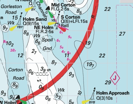
EAST COAST OF ENGLAND - North East Holm Lighted Buoy Moved to new assigned position: Latitude 52˚ 33.190’N., Longitude 001˚ 48.500’E. South Corton Lighted Buoy Moved to new assigned position: Latitude 52˚ 33.450’N., Longitude 001˚ 48.270’E. Movement effected consequent upon a recent survey. Trinity House No 14 of 2024 refers
|
Affects: UKHO SNC: 1504. UKHO SCC: 5614.4 (Panel A, Approaches to Great Yarmouth). Imray Full Charts: C28 New assigned positions of the North East Holm and South Corton Lighted Buoys which marks the south entrance of the Holm channel.
|
|
Week 31 |
EAST COAST OF ENGLAND - Amendment: Moved to new assigned position: Latitude 52° 40.344’N., Longitude 001° 46.329’E. No further notice will be given. Trinity House No 15 of 2024 refers
|
Affects: UKHO SNC: 1504. UKHO SCC: 5614.5 (Panel A, Northern Approaches to Great Yarmouth). Imray Full Charts: C28 A slight move of the North West Scroby lit buoy to the south.
|
|
Week 30 |
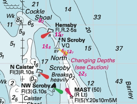
ENGLAND - Insert depth, 13.4 at 52° 43´·51N., 1° 45´·90E. Delete depth, 17.2, close N. depth, 13.6, enclosed by 15m contour at 52° 41´·41N., 1° 47´·32E. depth, 13.4, enclosed by 15m contour at 52° 41´·13N., 1° 47´·46E. Delete depth, 15.7, close S. Notice 3513 refers Base image courtesy of Imray ID10 Chart C28 and Meridian Chartware.
|
Affects: UKHO SNC: 1504. UKHO SCC: 5614.5 (Panel A, Northern Approaches to Great Yarmouth). Imray Full Charts: C28 Further reductions of depth on the Winterton Overfalls: three reductions, all over 13m. There have been two previous NstM this year (Nos 1974 and 2404) so I have show the latter in blue and this notice in magenta on the image.
|
|
Week 30 |
ENGLAND - Insert: depth, 6.1 at 52° 37´·70N., 1° 51´·55E. Delete depth, 7.2, close E. depth, 5.1 at 52° 35´·08N., 1° 48´·63E. Replace: depth, 11.9, with depth, 10.9 at 52° 37´·43N., 1° 52´·49E. Notice 3552 refers Base image courtesy of Imray ID10 Chart C28 and Meridian Chartware.
|
Affects: UKHO SNC: 1504. UKHO SCC: 5614.4 (Panel A, Approaches to Great Yarmouth). Imray Full Charts: C28 Three reductions of depth, two north of the South Cross Sand and one at the Corton Sand. This area has had a lot of attention this year so both images includes all the earlier reductions of depth.
|
|
Week 29 |
ENGLAND - Insert: depth, 10.6 at 52° 46´·273N., 1° 55´·46E. Delete depth, 17.5, close W and depth, 11.8, close NW. depth, 7 at 52° 43´·73N., 1° 57´·94E. Delete depth, 7.7, close NW and depth 8.7, close SW. depth, 10, enclosed by 10m contour at 52° 45´·74N., 1° 52´·56E. Delete depth, 11.7, close NW. and depth, 12.9, close SE. depth, 9.3, and extend 10m contour SE to enclose 52° 42´·91N., 1° 58´·30E. depth, 10, enclosed by 10m contour at 52° 42´·41N., 1° 58´·51E. Delete depth, 11.8, close NW. Replace: depth, 9.7, with depth, 9 at 52° 46´·60N., 1° 52´·27E. Notice 3457 refers Base image courtesy of Imray ID10 Chart C28 and Meridian Chartware.
|
Affects: UKHO SNC: 1401 and1504. UKHO SCC: This update is included in New Edition 5614.2, published 4 July 2024. Imray Full Charts: C28 Six reductions on and around the Newarp Banks (off Winterton Ness). Unlikely to hinder leisure craft.
|
|
Week 27 |
ENGLAND - Insert: depth, 7.6 at 52° 39´·90N., 1° 46´·72E. Delete depth, 8.7, close NE. depth, 8.9, and extend 10m contour W to enclose 52° 39´·83N., 1° 46´·49E. Delete depth, 11.4, close S. depth, 4.9, enclosed by 5m contour at 52° 38´·96N., 1° 46´·85E. depth, 3.3, enclosed by 5m contour at 52° 38´·78N., 1° 46´·81E. depth, 4.6, enclosed by 5m contour at 52° 38´·66N., 1° 46´·77E. Delete depth, 5.8, close S. Insert out of position, depth, 5.3 at 52° 37´·90N., 1° 45´·02E. Delete depth, 6.1, close SE. Notice 3058 refers Base image courtesy of Imray ID10 Chart C28 and Meridian Chartware.
|
Affects: Note: This update is included in New Editions 1534, published 23 May 2024 and New Edition 1543, published 30 May 2024 and New Edition 5614.2 and 5614.6, published 4 July 2024. UKHO SCC: 5614.4 (Panel A, Approaches to Great Yarmouth) Imray Full Charts: C28 Another notice with reduced depths on the west side of the Scroby Sands immediately after Notice 2946 in last week! This is five reduced depths alongside the swest side of the Scroby Sans and one correction on the south tail of the Caister Sand. The image includes reduced depths showing Notice 2946’s depths.
|
|
Week 27 |
ENGLAND - Insert: depth, 2.6 at 52° 34´·26N., 1° 47´·38E. Delete depth, 3.3, close NW. depth, 4.5, enclosed by 5m contour at 52° 34´·27N., 1° 48´·67E. Delete depth, 7.3, close E. depth, 2.9, and extend 5m contour W to enclose 52° 34´·06N., 1° 49´·28E. Delete depth, 4.6, close E. depth, 3.8, enclosed by 5m contour at 52° 33´·96N., 1° 49´·27E. Delete depth, 7.2, close W. depth, 6.5 at 52° 32´·13N., 1° 49´·04E. Delete depth, 7.8, close N. depth, 1.2, enclosed by 2m contour at 52° 30´·54N., 1° 48´·48E. Delete depth, 9.1, close E. depth, 8.7, and extend 10m contour E to enclose 52° 30´·33N., 1° 48´·60E. Delete depth, 12, close S. depth, 5.4 at 52° 30´·14N., 1° 48´·34E. Delete depth, 8.9, close N. depth, 8.5, enclosed by 10m contour at 52° 29´·47N., 1° 48´·37E. Delete depth, 10.4, close E depth, 6.1 at 52° 41´·26N., 1° 46´·77E. depth, 19, enclosed by 20m contour at 52° 40´·75N., 1° 46´·11E. depth, 0.8, enclosed by 2m contour at 52° 36´·99N., 1° 46´·75E. depth, 2.6 at 52° 34´·26N., 1° 47´·38E. Delete depth, 3.3, close NW. Notice 3111 refers Base image courtesy of Imray ID10 Chart C28 and Meridian Chartware.
|
Affects: Note: This update is included in New Editions 1534, published 23 May 2024 and New Edition 1543, published 30 May 2024 and New Edition 5614.2 and 5614.6, to be published 4 July 2024. UKHO SCC: 5614.3, 5641.4 (Panel A, Approaches to Great Yarmouth) and 5614.5 (Panel A, Northern Approaches to Great Yarmouth) Imray Full Charts: C28 Eleven more reduced depths in the approaches to Great Yarmouth. There have now been 5 other Notices earlier this year viz: 1641, 2639, 2946, 2963 and 3008. There are 4 images incorporating all the reductions.
|
|
Week 26 |
ENGLAND - Insert: depth, 7.7 at 52° 33´·26N., 1° 45´·58E. Delete depth, 8.7, close N. depth, 8.9 at 52° 32´·66N., 1° 45´·86E. Delete depth, 9.6, close NW. depth, 10.7 at 52° 32´·39N., 1° 46´·27E. Delete depth, 10.8, close NW and depth, 11.5, close NE. depth, 9.7, enclosed by 10m contour at 52° 30´·98N., 1° 46´·58E. Delete depth, 11, close N and depth, 10.9, close S. depth, 3. 1 at 52° 30´·12N., 1° 46´·76E. Delete depth, 3.6, close NE. depth, 4.4, and extend 5m contour W to enclose 52° 30´·07N., 1° 46´·72E. Delete depth, 9.6, close S. depth, 4.8, and extend 5m contour W to enclose 52° 29´·49N., 1° 47´·02E. Delete depth, 7.8, close S. Replace: depth, 6.7, with depth, 5.3 at 52° 29´·23N., 1° 47´·22E. Notice 3008 refers Base image courtesy of Imray ID10 Chart C28 and Meridian Chartware
|
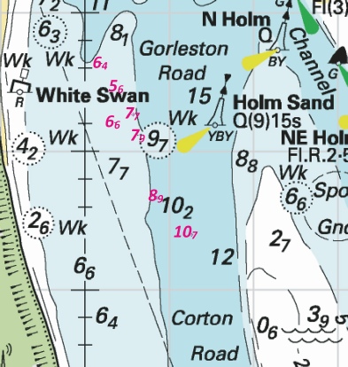
Affects: Note: This update is included in New Editions 1534 and 1535, published 23 May 2024 and New Edition 1543, published 30 May 2024 and New Edition 5614.2, published 4 July 2024. UKHO SCC: 5614.3 and 5641.4 (Panel A, Approaches to Great Yarmouth) Imray Full Charts: C28 8 reduction of depth, 3 in Gorleston Road in the south approaches to Great Yarmouth and 5 further south in Corton Road. Two images; the first image includes 4 reductions of depth in Gorleston Road lat week vide NtM 2873. The reductions are unlikely to hinder leisure craft.
|
|
Week 26 |
ENGLAND - Insert: depth, 2.1, and extend 5m contour NE to enclose 52° 40´·65N., 1° 52´·20E. depth, 2.3, and extend 5m contour E to enclose 52° 34´·69N., 1° 48´·32E. Delete depth, 7.2, close N. depth, 1.3, and extend 2m contour NW to enclose 52° 34´·61N., 1° 48´·41E. depth, 1.7, and extend 2m contour SE to enclose 52° 34´·47N., 1° 48´·59E. depth, 1.8, enclosed by 2m contour at 52° 34´·39N., 1° 48´·72E. depth, 3.7, enclosed by 5m contour at 52° 34´·37N., 1° 48´·52E. Delete depth, 16, and associated 15m contour close S. depth, 5, enclosed by 5m approximate contour at 52° 37´·21N., 1° 46´·44E. Delete depth, 9.3, and associated 10m approximate contour close E. depth, 9.8, and extend 10m contour W to enclose 52° 40´·10N., 1° 46´·58E. Delete depth, 11.8, close E. depth, 6.1, and extend 10m approximate contour W to enclose 52° 37´·41N., 1° 46´·53E. Delete depth, 12.8, close SE. Replace: depth, 8.3, with depth, 5.7 at 52° 38´·87N., 1° 46´·73E. Notice 2946 refers Base image courtesy of Imray ID10 Chart C28 and Meridian Chartware.
|
Affects: UKHO SNC: 1504 UKHO SCC: 5614.3, 5614.4 (Panel A, Approaches to Great Yarmouth and 5614.5 (Panel A, Northern Approaches to Great Yarmouth) Imray Full Charts: C28 Note: This update is included in New Editions 1534 and 1535, published 23 May 2024 and New Edition 1543, published 30 May 2024 and New Edition 5614.2 and 5614.6, published 4 July 2024. Ten reductions of depth off Great Yarmouth. One on the east side of the Middle Cross Sand, four on the west side of the Scroby Sands between the NW. Scroby and the Scroby Elbow buoys and five in the narrow channel east of the Corton Sands. These latter five are shallow and in the centre of that ‘channel’ depth is reduced from 16m to 3.7m! Three images.
|
|
Week 26 |
ENGLAND - Insert: depth, 6.3 at 52° 32´·34N., 1° 48´·82E. Delete depth, 7, close S. depth, 7.4 at 52° 33´·66N., 1° 48´·02E. Delete depth, 8.1, close SE. Notice 2963 refers Base image courtesy of Imray ID10 Chart C28 and Meridian Chartware.
|
Affects: UKHO SNC: Note: This update is included in New Editions 1534 and 1535, published 23 May 2024 and New Edition 1543, published 30 May 2024 and New Edition 5614.2, published 4 July 2024. UKHO SCC: 5614.3 and 5614.4 (Panel A Approaches to Great Yarmouth) Imray Full Charts: C28 Two reductions of depth in the Holm Channel southern approaches to Great Yarmouth. One right by the Mid Corton SHB and the other in the south entrance to the channel. Neither would hinder leisure craft but continuing reductions in that whole area.
|
|
Week 25 |
New ADMIRALTY Small Craft Charts to be published on 4th July, 2024 SCC 5614.1 A Orford Ness to Benacre Ness. 1:75,000 B Orford Ness. 1:50,000 SCC 5614.2 Lowestoft to Winterton Ness. 1:75,000 SSS 5614.6 A Caister- B Southwold Harbour. 1:7,500 |
Includes full updates for New Edition and Notices to Mariners affecting source charts. |
|
Week 25 |
ENGLAND - Insert: depth, 9.7, enclosed by 10m contour at 52° 34´·754N., 1° 44´·335E. Delete depth, 10.5, close N. depth, 9.1, and extend 10m contour N to enclose 52° 34´·626N., 1° 44´·768E. Delete depth, 10.7, close N. depth, 2.2 at 52° 34´·320N., 1° 44´·152E. Delete depth, 3, close N. depth, 5, enclosed by 5m contour 52° 35´·438N., 1° 43´·629E. depth, 6.4 at 52° 33´·63N., 1° 45´·20E. Delete depth, 8.6, close NW. depth, 5.6 at 52° 33´·38N., 1° 45´·35E. Delete depth, 7.8, close NW. depth, 6.6 at 52° 33´·20N., 1° 45´·36E. Delete depth, 8.3, close NW. depth, 7.9 at 52° 33´·11N., 1° 45´·63E. Delete depth, 9, close SW. Replace: depth, 0.4, with drying height, 0.1, and extend 0m low water line SE to enclose 52° 35´·036N., 1° 43´·778E. Notice 2873 refers Base image courtesy of Imray ID10 Chart C28 and C28C and Meridian Chartware.
|
Affects: Note: This update is included in New Editions 1534 and 1535, published 23 May 2024 and New Edition 1543, published 30 May 2024 and New Edition SCC 5614.2, published 4 July 2024. UKHO SCC: 5614.4 (Panel B, Great Yarmouth Outer Harbour), 5614.5 (Panel B, Great Yarmouth Haven), 5614.3 and 5614.4 (Panel A, Approaches to Great Yarmouth) Imray Full Charts: C28 Three reduction of depth in the Great Yarmouth Outer Harbour (commerce only), four reductions of depth on the eastern ‘bank’ of the Gorleston Road and two on the west ban k of the River Yare. I cannot illustrate the changes in the River Yare.
|
|
Week 24 |
ENGLAND - Insert: depth, 4.9, and extend 5m contour E to enclose 52° 34´·20N., 1° 49´·13E. Delete depth, 6.5, close N. depth, 3.5, and extend 5m contour E to enclose 52° 40´·42N., 1° 47´·45E. Delete depth, 2.6, close SW and depth, 7.1, close NE. depth, 13.6, and extend 15m contour E to enclose 52° 40´·55N., 1° 47´·83E. Delete depth, 21.5, and associated 20m contour close SW. depth, 6.8, and extend 10m contour SE to enclose 52° 38´·72N., 1° 49´·13E. Delete depth, 9.6, close N depth, 1.9, enclosed by 2m contour at 52° 38´·52N., 1° 48´·40E. depth, 1, enclosed by 2m contour at 52° 38´·33N., 1° 48´·58E. Delete depth, 6.7, close SE. Notice 2639 refers Base image courtesy of Imray ID10 Chart C28 and Meridian Chartware.
|
Affects: UKHO SNC: Note: This update is included in New Editions 1534 and 1535, published 23 May 2024 and New Edition 1543, published 30 May 2024. UKHO SCC: 5614..4 (Panel A, Approaches to Great Yarmouth), 5614.5 (Panel A, Northern Approaches to Great Yarmouth), 5614.2 and 5614.6 (Panel A, Caister- Imray Full Charts: C28 One reduction of depth east of the Corton Sand and five reductions of depth on the eastern edge of the Scroby Sands. Not where you would normally be.
|
|
Week 22 |
ENGLAND - Insert symbol, overfalls at: 52° 44´·42N., 1° 45´·22E., and 52° 44´·11N., 1° 42´·72E. depth, 17.5, and extend 20m contour N to enclose 52° 46´·98N., 1° 47´·91E. depth, 16.3, and extend 20m contour NE to enclose 52° 46´·01N., 1° 47´·64E. Delete depth, 26, close E. depth, 11.6, and extend 15m contour NE to enclose 52° 45´·65N., 1° 48´·12E. Delete depth, 11.4, close SW. depth, 14.6, and extend 15m contour NW to enclose 52° 44´·29N., 1° 45´·35E. depth, 9.9, enclosed by 10m contour at 52° 44´·19N., 1° 45´·49E. Delete depth, 10.9, close SE. depth, 13.8, and extend 15m contour SE to enclose 52° 43´·28N., 1° 46´·10E. depth, 13.4, and extend 15m contour N to enclose 52° 42´·89N., 1° 46´·42E. Delete depth, 13.9, close S. depth, 14.3, and extend 15m contour NW to enclose 52° 42´·42N., 1° 46´·85E. Delete depth, 16.6, close E. Notice 2404 refers Base image courtesy of Imray ID10 Chart C28 and Meridian Chartware.
|
Affects: UKHO SNC: 1504. Note: This update is included in New Edition 1534, published 23 May 2024 and New Edition 1543, published 30 May 2024. UKHO SCC: 5614.2 and 5614.6 (Panel A, Caister- Imray Full Charts: C28 A survey around the Winterton Shoal (off Winterton Ness) has prompted 8 reductions of depth and two new areas of overfalls. All of the depths have ample water for leisure craft but the overfalls will be relevant to us, one of which is west of the Cockle east cardinal buoy for the inshore route, the other to the east of the Cockle leading into the Barley Picle.
|
|
Week 22 |
ENGLAND - Insert: harbour limit, pecked line, joining: 52° 14´·00N., 1° 37´·59E. 52° 14´·00N., 1° 41´·00E. 52° 12´·00N., 1° 41´·00E. 52° 12´·00N., 1° 37´·40E. legend, Sizewell C Harbour Limit, along W side of: 52° 14´·00N., 1° 41´·00E. 52° 12´·00N., 1° 41´·00E. Notice 2423 refers Base image courtesy of Imray ID10 Chart C28 and Meridian Chartware.
|
Affects: UKHO SNC: 1543 and this update is included in New Edition 1543, published mid 2024. UKHO SCC: 5614.1 (Panel A, Orford Ness to Benacre Ness) Imray Full Charts: C28 Harbour limits for Sizewell C have been defined. The limits extend due east from the bank for two nautical miles.
|
|
Week 21 |
ENGLAND - Delete:
(a) 52° 35´·845N., 1° 43´·633E. (b) 52° 35´·819N., 1° 43´·633E. pontoon, single firm line, joining: (a)- Notice 2281 refers
|
Affects: UKHO SCC: 56014.5 (Panel B, Great Yarmouth Haven) Imray Full Charts: C28 Deletion of light and pontoon in the River Yare at the commercial wharfs (I believe at the Trinity Wharf, east bank). Not illustrated. |
|
Week 20 |
New Editions of ADMIRALTY Charts to be published on 30th May, 2024 Chart 1543 England - |
Includes changes to depths from the latest British Government and Trinity House surveys. |
|
Week 19 |
New Editions of ADMIRALTY Charts to be published on 23rd May, 2024 Chart 1534 - A Great Yarmouth Outer Harbour. 1:7,500 B Great Yarmouth Haven. 1:7,500 Chart 1535 - Lowestoft Harbour. 1:6,250 |
Includes changes to depths from the latest British Government, Trinity House and Great Yarmouth Port Authority surveys. |
|
Week 18 |
ENGLAND - Insert: depth, 8.2, and extend 10m approximate contour SE to enclose 52° 42´·10N., 1° 45´·81E. Delete depth, 8.6, close NW. depth, 15.7, and extend 20m contour E to enclose 52° 41´·72N., 1° 46´·54E. depth, 11.8, and extend 15m contour E to enclose 52° 41´·44N., 1° 46´·00E. depth, 7.4, and extend 10m contour E to enclose 52° 41´·24N., 1° 46´·84E. Delete depth, 9.3, close NW. depth, 13.7, and extend 15m contour NE to enclose 52° 41´·28N., 1° 47´·02E. Delete depth, 15.5, close N and depth, 15.3, close SE. depth, 12.5, and extend 15m contour N to enclose 52° 40´·73N., 1° 47´·50E. depth, 5.5, enclosed by 10m contour at 52° 37´·55N., 1° 49´·14E. depth, 7.2, enclosed by 10m contour at 52° 37´·04N., 1° 49´·15E. depth, 5.7, enclosed by 10m contour at 52° 36´·86N., 1° 49´·13E. depth, 3.2, enclosed by 5m contour at 52° 36´·69N., 1° 49´·01E. depth, 12.8, enclosed by 15m contour at 52° 36´·55N., 1° 49´·16E. depth, 9.7, and extend 10m contour E to enclose 52° 36´·32N., 1° 49´·02E. Delete depth, 17.5, close SE. depth, 4.7, enclosed by 5m contour at 52° 34´·77N., 1° 48´·62E. Delete depth, 11.2, close NW. depth, 3.7, and extend 5m contour W to enclose 52° 34´·63N., 1° 48´·71E. Delete depth, 7.5, close NE. Notice 1974 refers Base image courtesy of Imray ID10 Chart C28 and Meridian Chartware.
|
Affects: UKHO SNC: 1534, 1535 and 1543.. UKHO SCC: 5614.4 (Panel A, Approaches to Great Yarmouth, 5614.5 (Panel A, Northern Approaches to Great Yarmouth) and Chart 5614.6 (Panel A, Caister- Imray Full Charts: C28 14 reductions of depth, 6 in and around the Hemsby and North Scroby buoys, six on the eastern side of the Scroby Sands and 2 on the Corton Sand channel. All still have sufficient depths for leisure craft but the general trend is probably worth attention. In one area the eastern edge of the Scroby Sand is pretty steep. Two images:
|
|
Week 15 |
ENGLAND - Insert: depth, 3.1, and extend 5m contour SE to enclose 52° 31´·21N., 1° 48´·69E. Delete depth, 4.5, close N. depth, 3.3, and extend 5m contour SE to enclose 52° 30´·28N., 1° 48´·34E. Delete depth, 3.1, close NW. depth, 9.6, and extend 10m contour S to enclose 52° 29´·78N., 1° 49´·70E. depth, 2.2, and extend 5m contour N to enclose 52° 34´·07N., 1° 49´·18E. Delete depth, 4.6, close E. Notice 1641 refers Base image courtesy of Imray ID10 Chart C28 and Meridian Chartware.
|
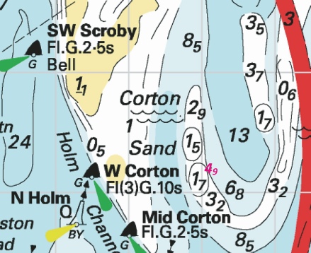
Affects: UKHO SNC: 1534, 1535 and 1543. UKHO SCC: 5614.3 and 5614.4 (Panel A, Approaches to Great Yarmouth) Imray Full Charts: C28 Four reductions of depth, three on the east side of the Holm Sand just north of Lowestoft and one on the east side of the Mid Corton Sand off Great Yarmouth.
|
|
Week 14 |
ENGLAND - Insert:
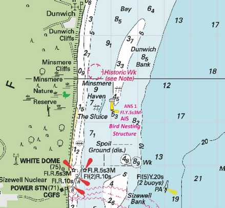
Automatic Identification System, AIS, at light, and legend, Bird Nesting Structure, close SE. at 52° 14´·28N., 1° 39´·02E.
Automatic Identification System, AIS, at light at 52° 27´·63N., 1° 45´·80E. Delete:
Automatic Identification System, AIS, at light, and legend, Bird Nesting Structure, close NE at 52° 27´·72N., 1° 45´·82E. Delete:
Notice 1502 refers Base image courtesy of Imray ID10 Chart C1 and Meridian Chartware.
|
Affects: UKHO SNC: 1504, 1535, 1543 and 1610. UKHO SCC: 5614.1 (Panel A, Orford Ness to Benacre Ness) and 5614.2 Imray Full Charts: C28 This notice confirms the Preliminary Notice 2318(T) of last year. This marks the three Bird Nesting Structures, two off Lowestoft, the third, off Minsmere. The Notices adds AIS on all three Structures and a legend on charts. Light characteristics remain as reported last year.
|
|
Week 13 |
ENGLAND - Move:
to: 52° 41´·56N., 1° 46´·53E. Notice 1367 refers Base image courtesy of Imray ID10 Chart C28 and Meridian Chartware.
|
Affects: UKHO SNC: 1534 and 1543. UKHO SCC: 5614.2, 5614.5 (Panel A, Northern Approaches to Great Yarmouth) and 5614.6 (Panel A, Caister- Imray Full Charts: C28 The North Scroby north cardinal buoy has been moved a small distance to the north. The North Scroby sands break heavily.
|
|
Week 13 |
ENGLAND - Insert: depth, 8.6, and extend 10m contour E to enclose 52° 37´·66N., 1° 45´·14E. Delete depth, 13, close SE. Notice 1434 refers Base image courtesy of Imray ID10 Chart C28 and Meridian Chartware.
|
Affects: UKHO SNC: 1534. UKHO SCC: 5614.5 (Panel A, Northern Approaches to Great Yarmouth) Imray Full Charts: C28 One single significant reduction of depth off shore north of Great Yarmouth. The reduction is just north of an outfall pipe. The end of the outfall is marked by a lit port hand buoy which also marks the lateral edge of the Caister Road.
|
|
Week 12 |
ENGLAND - Insert: legend, Works in progress (2023), orientated 222°/42°, centred on: 52° 28´·407N., 1° 45´·454E. Notice 1224 refers Base image courtesy of Imray ID10 Chart C28H and Meridian Chartware.
|
Affects: UKHO SNC: 1535 (Panel A, Lowestoft Harbour). UKHO SCC: 5614.20 (Panel A, Lowestoft Harbour) Imray Full Charts: C28H ‘Works in progress (2023) to be annotated on the east side of Waveney Dock in Lowestoft Harbour.
|
|
Week 12 |
ENGLAND - Chart 1534, Chart 5614.4 (Panel A, Approaches to Great Yarmouth) and Chart 5614.5 (Panel A, Northern Approaches to Great Yarmouth) Insert: bridge, double firm line, width 27m, joining: 52° 35´·58N., 1° 43´·52E. 52° 35´·58N., 1° 43´·61E. Chart 1534 (Panel B, Great Yarmouth Haven) [ previous Insert: the accompanying block , centred on: 52° 35´·6N., 1° 43´·6E. Chart 5614.5 (Panel B, Great Yarmouth Haven) Insert: the accompanying block , centred on: 52° 35´·6N., 1° 43´·6E. Notice 1251 refers UKHP Blocks are copyright.
|
Affects: UKHO SNC: 1534, 1534 (Panel B, Great Yarmouth Haven). UKHO SCC: 5614.5 (Panel B, Great Yarmouth Haven). Imray Full Charts: C28 Two new UKHO blocks marking the new bridge now opened in Great Yarmouth Haven: one block is for a SN Chart, the other for a SC chart. Other SNC and SCCs are to be drawn in on charts.
|
|
Week 12 |
ENGLAND - Insert:
Notice 1295 refers Base image courtesy of Imray ID10 Chart C28 and Meridian Chartware.
|
Affects: UKHO SNC: 1503 and 1504. UKHO SCC: 5606.2 and 5607.2 Imray Full Charts: C28 New lit port hand buoy close inshore close to the Gas Terminals at Bacton, Norfolk.
|
|
Week 12 |
ENGLAND - Insert: depth, 4.2, and extend 5m contour NW to enclose 52° 28´·309N., 1° 45´·654E. Delete depth, 4.9, close SW. depth, 3.6, and extend 5m contour NW to enclose 52° 28´·273N., 1° 45´·593E. Delete depth, 4.9 , close NE. depth, 1.5, enclosed by 2m contour at 52° 28´·259N., 1° 45´·633E. Delete depth, 4.1, close SW, depth, 2.4, close SE and depth, 4.3, close W. Notice 1300 refers Base image courtesy of Imray ID10 Chart C28D and Meridian Chartware.
|
Affects: UKHO SNC: 1535 (Panel, Lowestoft Harbour) and 1535. UKHO SCC: 5614.20 (Panel A, Lowestoft Harbour) and 5614.3 Imray Full Charts: C28D and C28H. Three new reduced depths just outside the entrance of Lowestoft Harbour: two still have ample water but the third is at 1.5m, a significant reduced from 4+m on the Lowestoft Bank hindering access to or from the Stanford Channel. Worth noting. A depth of 4.9m is added from an earlier NtM this year
|
|
Week 11 |
ENGLAND - Insert: symbol, overfalls at 52° 26´·29N., 1° 46´·84E. Notice 1190 refers Base image courtesy of Imray ID10 Chart C28 and Meridian Chartware.
|
Affects: UKHO SNC: 1535 and 1543. UKHO SCC: 5614.1 (Panel A, Orford Ness to Benacre) and 5614.2 Imray Full Charts: C28 A new ‘Overfalls’, a new symbols is placed just west of the Newcome Sand port hand buoy: i.e. the overfalls are just outside of the channel at the south entrance of the Stanford Channel to Lowestoft.
|
|
Week 10 |
ENGLAND - Insert: depth, 4.9 , and extend 5m contour NW to enclose 52° 28´·294N., 1° 45´·607E. Notice 1027 refers Base image courtesy of Imray ID10 Chart C28D and Meridian Chartware.
|
Affects: UKHO SNC: 1535 and 1535 (Panel, Lowestoft Harbour). UKHO SCC: 5614.20 (Panel A, Lowestoft Harbour) and 5614.3 Imray Full Charts: C28D One reduction of depth in the approaches to Lowestoft Harbour entrance. Unlikely to hinder leisure craft.
|
|
Week 10 |
ENGLAND - Replace:
Insert: depth, 1.7 , and extend 2m approximate contour E to enclose 52° 30´·93N., 1° 48´·54E. Delete depth, 7.1 , close NE. Notice 1082 Base image courtesy of Imray ID10 Chart C28 and Meridian Chartware.
|
Affects: UKHO SNC: 1535 and 1543. UKHO SCC: 5614.2. Imray Full Charts: C28 A wreck on the eastern side of the Holm Sand (off Lowestoft) is deleted and a reduced depth of 1.7m placed in lieu.
|
|
Week 09 |
ENGLAND - Note: This update is included in New Edition 106, published 22 February 2024. Insert depth, 7.7, and extend 10m contour NE to enclose 52° 44´·09N., 1° 57´·77E. Delete depth, 8.7, close S and depth, 8.8, close SW. depth, 9.8, enclosed by 10m contour at 52° 41´·42N., 1° 59´·03E. Delete depth, 10.8, close S. depth, 9.7, enclosed by 10m contour at 52° 46´·59N., 1° 52´·25E. Delete depth, 10.1, close S. Notice 911 refers Base image courtesy of Imray ID10 Chart C28 and Meridian Chartware.
|
Affects: UKHO SNC: 1408, 1504 and 1543. UKHO SCC: 5614.2 Imray Full Charts: C28 Three reductions of depth variously on the Newarp Banks well off Scroby and Hemsby. Unlikely to hinder leisure craft.
|
|
Week 08 |
New Editions of ADMIRALTY Charts to be published 22 February 2024 Chart 106 - Note: This chart is to be deleted from the list of charts affected by Notice 2900(T)/19. This chart remains affected by Notice 482(T)/24. Chart 108 England - 1:75,000 Wells- |
Includes significant safety- |
|
Week 03 |
ENGLAND - Insert: depth, 13.6, and extend 15m contour E to enclose 52° 38´·05N., 1° 52´·40E. depth, 11.7, enclosed by 15m contour 52° 37´·93N., 1° 52´·42E. Delete depth, 17.9, close N. depth, 9.4, and extend 10m contour N to enclose 52° 37´·89N., 1° 51´·84E. Delete depth, 9.7, close SW. depth, 14.2, enclosed by 15m contour 52° 37´·67N., 1° 52´·62E. Delete depth, 18.5, close S. depth, 16.5, and extend 20m contour E to enclose 52° 37´·61N., 1° 52´·85E. depth, 11.9, and extend 15m contour E to enclose 52° 37´·44N., 1° 52´·55E. Delete depth, 19.9, close NE. depth, 16.7, and extend 20m contour E to enclose 52° 37´·30N., 1° 52´·66E. Insert sounding out of position: depth 11.7, and extend 15m contour SE to enclose 52° 37´·93N., 1° 52´·42E. Delete depth, 13.7, close NW. depth, 13.6, and extend 15m contour E to enclose 52° 37´·52N., 1° 52´·57E. Notice 259 refers Base image courtesy of Imray ID10 Chart C28 and Meridian Chartware.
|
Affects: UKHO SNC: 1504, 1534 and 1543 UKHO SCC: 5614.2 Imray Full Charts: C28 9 reductions of depth in the entrance to the Barley Picle twixt the Middle Cross and South Cross Sands (offshore of Great Yarmouth). Some quite significant changes in depth but all still unlikely to hinder leisure craft.
|


-2.jpg)
.jpg)
-2.jpg)

-2.jpg)
%2024.jpg)
%2024.jpg)
 Fl(2)G.5s SW Holm
  VQ(6)+LFl.10s S Holm
 Q.R Newcome Sand
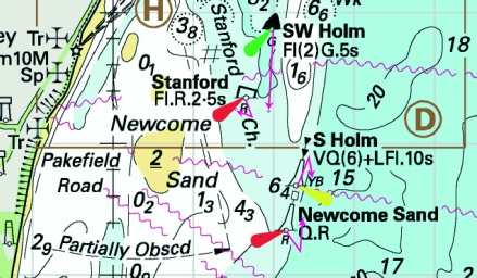
%2024.jpg)
%2024.jpg)
%2024.jpg)
%2024.jpg)
%2024.jpg)
%2024.jpg)
%2024.jpg)
%2024.jpg)

 Q(6)+LFl.15s S Corton Bell
 Fl.R.2·5s NE Holm
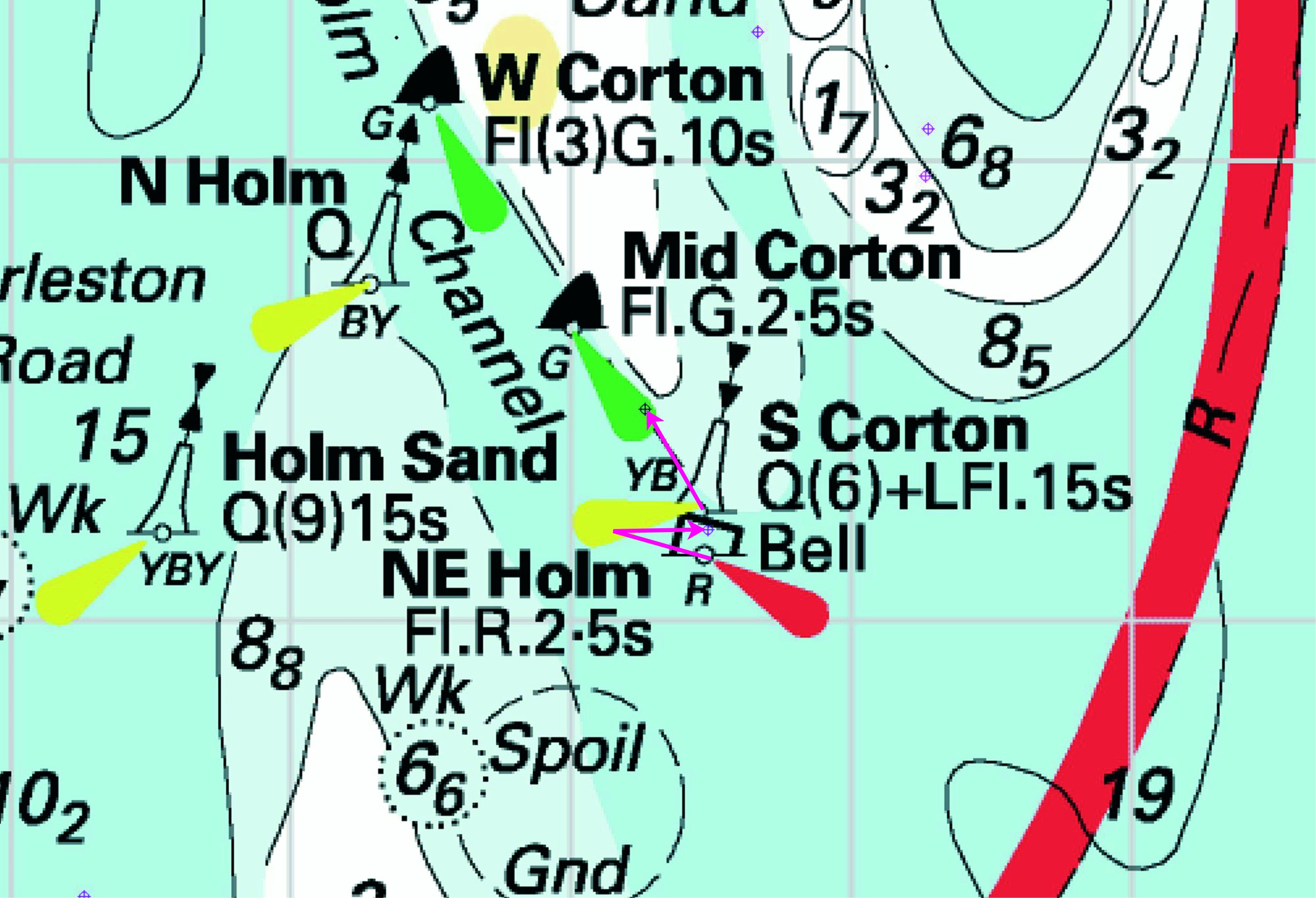

 at:
at: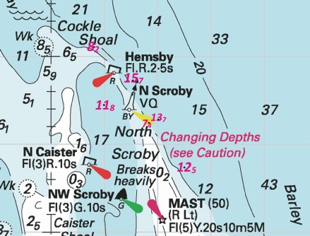
 Fl.Y.5s3M
 Fl.Y.5s3M, close NE of
 Fl.Y.2·5s3M, close NE of 52° 27´·72N., 1° 45´·82E.
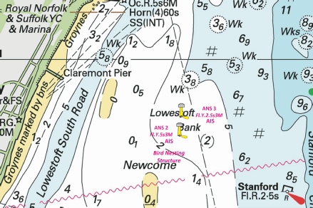
 VQ N Scroby
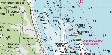
 Fl.R.5s
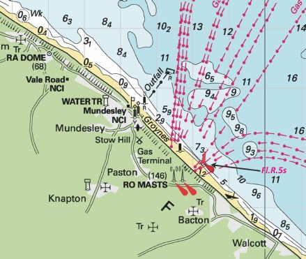
 with depth,