|
Notices - |
||
|
Week 16 |
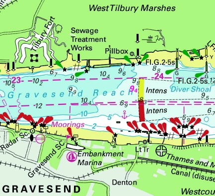
ENGLAND - Delete:
51° 26´·756N., 0° 22´·075E. and 51° 26´·753N., 0° 22´·123E. Notice 1661 refers Base image is from Imray chart IN5036 by courtesy of Imray and Meridian Chartware.
|
Affects: UKHO SNC: 1186 (Panel B, Coalhouse Point to Tilbury) and 2151 Imray Full Charts: C2 Imray Leisure Charts: 2100.3 Deletion of two ships moorings on the south side of Gravesend Reach, River Thames off Gravesend.
|
|
Week 12 |
ENGLAND - Insert:
51° 29´·01N., 0° 49´·20E. 51° 28´·72N., 0° 44´·63E. 51° 28´·71N., 0° 44´·40E. 51° 30´·11N., 1° 02´·41E. 51° 28´·71N., 0° 56´·60E. 51° 28´·72N., 0° 56´·41E. 51° 28´·80N., 0° 55´·11E.
Notice 1295 refers Base images are from Imray chart IN5037 and 5043 by courtesy of Imray and Meridian Chartware.
|
Affects: UKHO SNC: 1185, 1609 and 3683. Note: Former Notice 2704(T)/24 is cancelled. This update is included in New Edition 1607, published early 2024. UKHO SCC: 5606.7, 5606.9 and 5606.5 Imray Full Charts: C1 Imray Leisure Folios: 2100.2 Last year, following survey work for a new cable laying, unexploded ordnance was discovered – almost a single line of ordnance -
|
|
Week 10 |
New Editions of ADMIRALTY Charts to be published on 20th March, 2025 SN Chart 1607 International Chart Series, England - SN Chart 1975 England - SN Chart 2052 International Chart Series, England - SN Chart 2692 England - |
Charts 1607 and 1975 are important charts for us as these are followd by the echart makers. |
|
Week 9 |
ENGLAND - Insert: depth, 8.9 at 51° 29´·561N., 0° 28´·307E. Delete depth, 9, close NE. depth, 7.8 at 51° 29´·691N., 0° 28´·695E. Delete depth, 7.9, close NE. depth, 9.8 at 51° 29´·809N., 0° 29´·136E. depth, 11.9 at 51° 29´·899N., 0° 29´·828E. Delete depth, 12, close SW. Notice 1016 refers Base image is from Imray chart IN5036 by courtesy of Imray and Meridian Chartware.
|
Affects: UKHO SNC: 1186 (Panel A, Canvey Island to Coalhouse Point). Imray Full Charts: C2 Imray Leisure Folios: 2100.3 Four slight reductions of depth in Hope Reach/Sea Reach of the River Thames between the Lower Hope of Cliffe Fleet buoys. Unlikely to hinder leisure craft.
|
|
Week 9 |
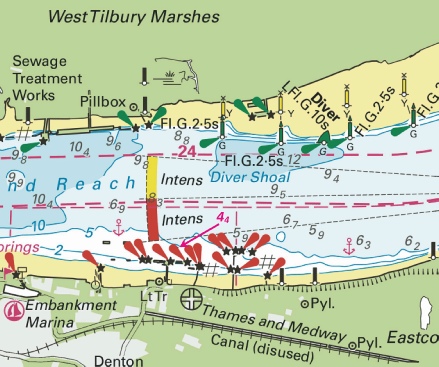
ENGLAND - Replace: depth, 8.4, with depth, 7.6 at 51° 26´·781N., 0° 21´·457E. Notice 1025 refers Base image is from Imray chart IN5036 by courtesy of Imray and Meridian Chartware.
|
Affects: UKHO SNC: 1186 (Panel B, Coalhouse Point to Tilbury) and 2151. Imray Full Charts: C2 Imray Leisure Folios: 2100.3 One reduction of depth in Gravesend Reach of the River Thames close to or alongside a Northfleet jetty. Unlikely to hinder leisure craft.
|
|
Week 8 |
ENGLAND - Insert: depth, 9.4 at 51° 26´·968N., 0° 23´·538E. Delete depth, 9.5, close SE. Notice 963 refers Base image is from Imray chart IN5036 by courtesy of Imray and Meridian Chartware.
|
Affects: UKHO SNC: 1186 (Panel B, Coalhouse Point to Tilbury) Imray Full Charts: C2 Imray Leisure Folios: 2100.3 One very small reduction in the centre of the Gravesend Reach of the River Thames. Unlikely to hinder leisure craft.
|
|
Week 7 |
New Editions of ADMIRALTY Charts to be published on 27th February, 2025 SN Chart 1185 - Continuation of Hole Haven Creek. 1:25,000 SN Chart 1606 - SN Chart 1609 - SN Chart 2693 - A Continuation of River Stour. 1:25,000 B Ipswich. 1:20,000 C Continuation of River Deben. 1:25,000 SN Chart 3683 - Sheerness. 1:6,250 |
|
|
Week 5 |
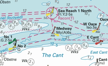
ENGLAND - Insert: depth, 11.1 at 51° 29´·30N., 0° 52´·89E. Delete depth, 12.1, close N. Notice 398 refers Base image is from Imray chart IN5043 by courtesy of Imray and Meridian Chartware.
|
Affects: UKHO SNC: 1607 and 1609. UKHO SCC: 5606.5. Imray Full Charts: C1 Imray Leisure Charts: 2100.1 and 2100.2 One reduction of depth just south of the Sea Reach No 1 yellow special lit buoy. Ample water for leisure craft.
|
|
Week 4 |
New Editions of ADMIRALTY Charts to be published on 30th January, 2025. SNC 1186 - A Canvey Island to Coalhouse Point. 1:12,500 B Coalhouse Point to Tilbury. 1:12,500 SNC 2151 - A Continuation at same scale. 1:12,500 SNC 3337 England - A Barking Creek. 1:6,250 B Thames Tidal Barrier. 1:5,000 |
|
|
SCROLL DOWN FOR 2024 NOTICES |
||
|
Week 50 |
ENGLAND - Works are in progress at the Oikos Jetty No.1, until approximately 15th February 2025, in an area bounded by the following positions: 51° 30´·593N., 0° 33´·237E. 51° 30´·625N., 0° 33´·244E. and 51° 30´·596N., 0° 33´·437E. 51° 30´·489N., 0° 33´·412E. 51° 30´·513N., 0° 33´·220E. 51° 30´·587N., 0° 33´·235E. Mariners are advised to navigate with caution in the area. Notice 5715(T) refers The image courtesy of the Port of London Authority.
|
Affects: UKHO SNC: 1185 and 1186. UKHO SCC: 5606.8. Imray Full Charts: C2 Imray Leisure Folios 2100.3 This notice duplicates the local PLA Notice No L74 reporting long term works at the Oikos Jetty in the Sea Reach of the River Thames. The area of works are on commercial jetties but are adjacent to the entrance at Holehaven Creek and would need care to be avoided.
|
|
Week 49 |
ENGLAND - Insert:
51° 27´·960N., 0° 18´·380E. and 51° 27´·894N., 0° 18´·295E. Notice 5503 refers The base image courtesy of Imray Chart IN5036 and Meridian Chartware.
|
Affects: UKHO SNC: 2151. UKHO SCC: 5606.14A Imray Full Charts: C2 Imray Leisure Folios 2100.3 Two new ship’s moorings in Fiddlers Reach of the River Thames close by Broadness Saltings.
|
|
Week 45 |
ENGLAND - Insert: depth, 4.2 at 51° 30´·510N., 0° 05´·328E. Delete depth, 4.8, close SW. depth, 6 at 51° 30´·175N., 0° 04´·753E. Delete depth, 6.2, close SW. Notice 5114 refers The base image courtesy of Imray Chart IN5030 and Meridian Chartware.
|
Affects: UKHO SNC: 2151 (Panel A, Continuation at same scale) and 3337. UKHO SCC: 5606.14 (Panel B. Erith Reach to Hook Ness). Imray Full Charts: C2 Imray Leisure Folios 2100.4 Two reduction of depth in Gallions Reach, River Thames. Unlikely to hinder leisure craft.
|
|
Week 45 |
ENGLAND - Replace: depth, 4.5 , with depth, 4.4 at 51° 26´·726N., 0° 23´·769E. Notice 5123 refers The base image courtesy of Imray Chart IN5036 and Meridian Chartware.
|
Affects: UKHO SNC: 1186 (Panel B, Coalhouse Point to Tilbury). UKHO SCC: 5606.13 (Panel A, Hole Haven to Gravesend Reach). Imray Full Charts: C2 Imray Leisure Folios 2100.3 One reduction of depth in Gravesend Reach, River Thames, east of the entrance to the Embankment Marina. Unlikely to hinder leisure craft.
|
|
Week 44 |
ENGLAND - Insert: depth, 5.8 at 51° 30´·790N., 0° 06´·929E. Notice 4991 refers The base image courtesy of Imray ID10 Chart IN5036 and Meridian Chartware.
|
Affects: UKHO SNC: 2151 (Panel A, Continuation at same scale). UKHO SCC: 5606.14B (Erith Reach to Hook Ness) Imray Full Charts: C2 Imray Leisure Folios 2100.4 One reduction of depth in the middle of the channel of Barking Reach, River Thames. Unlikely to hinder leisure craft.
|
|
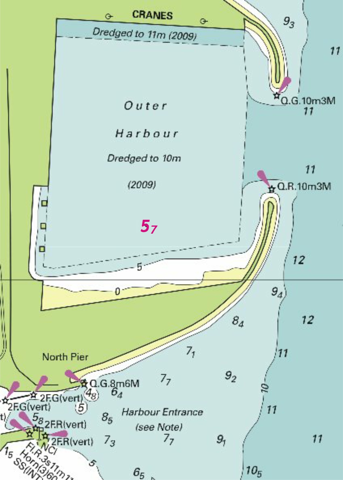
Week 44 |
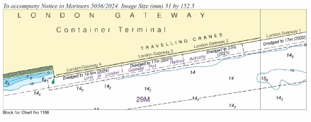
ENGLAND - Insert: the accompanying block, centred on 51° 30´·2N., 0° 29´·4E. Notice 5036 refers The blocks are copyright of the UKHO
|
Affects: UKHO SNC: 1186 (Panel A, Canvey Island to Coalhouse Point). UKHO SCC: 5606.13. Imray Full Charts: YC2 Imray Leisure Folios 2100.3 This notice announces a new UKHO block for the wharfs at the London Gateway Terminals, west of the Yantlet, River Thames. Not where we ought to be!
|
|
Week 43 |
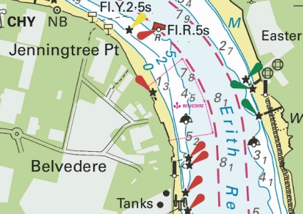
ENGLAND - Insert: limit of anchorage area, pecked line, joining: (a) 51° 29´·851N., 0° 10´·300E. (b) 51° 29´·882N., 0° 10´·550E. (c) 51° 29´·992N., 0° 10´·503E. (d) 51° 30´·073N., 0° 10´·446E. (e) 51° 30´·142N., 0° 10´·376E. (f) 51° 30´·041N., 0° 10´·165E. legend, BELVEDERE, within (a)- Notice 4809 refers The base image courtesy of Imray ID10 Chart IN5036 and Meridian Chartware.
|
Affects: UKHO SNC: 2151 (PANEL A continuation at same scale) UKHO SCC: 5606.14. Imray Full Charts: C2 Imray Leisure Folios 2100.4A An amended ship’s anchorage in the River Thames in Erith Reach off Jenningtree Point.
|
|
Week 41 |
ENGLAND - Replace:
Notice 4645 refers The base image courtesy of Imray ID10 Chart IN5037 and Meridian Chartware.
|
UKHO SNC: 1185. UKHO SCC: 5606.7, 5606.8 and 5606.9. Imray Full Charts: C2 Imray Leisure Folios 2100.2 Adjustment of depth over a wreck in the Yantlet northern secondary channel adjacent to the Sea Reach 4 North. Unlikely to hinder leisure craft – or where we ought to be!
|
|
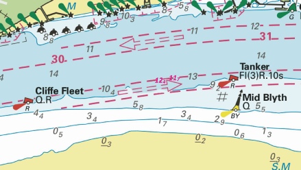
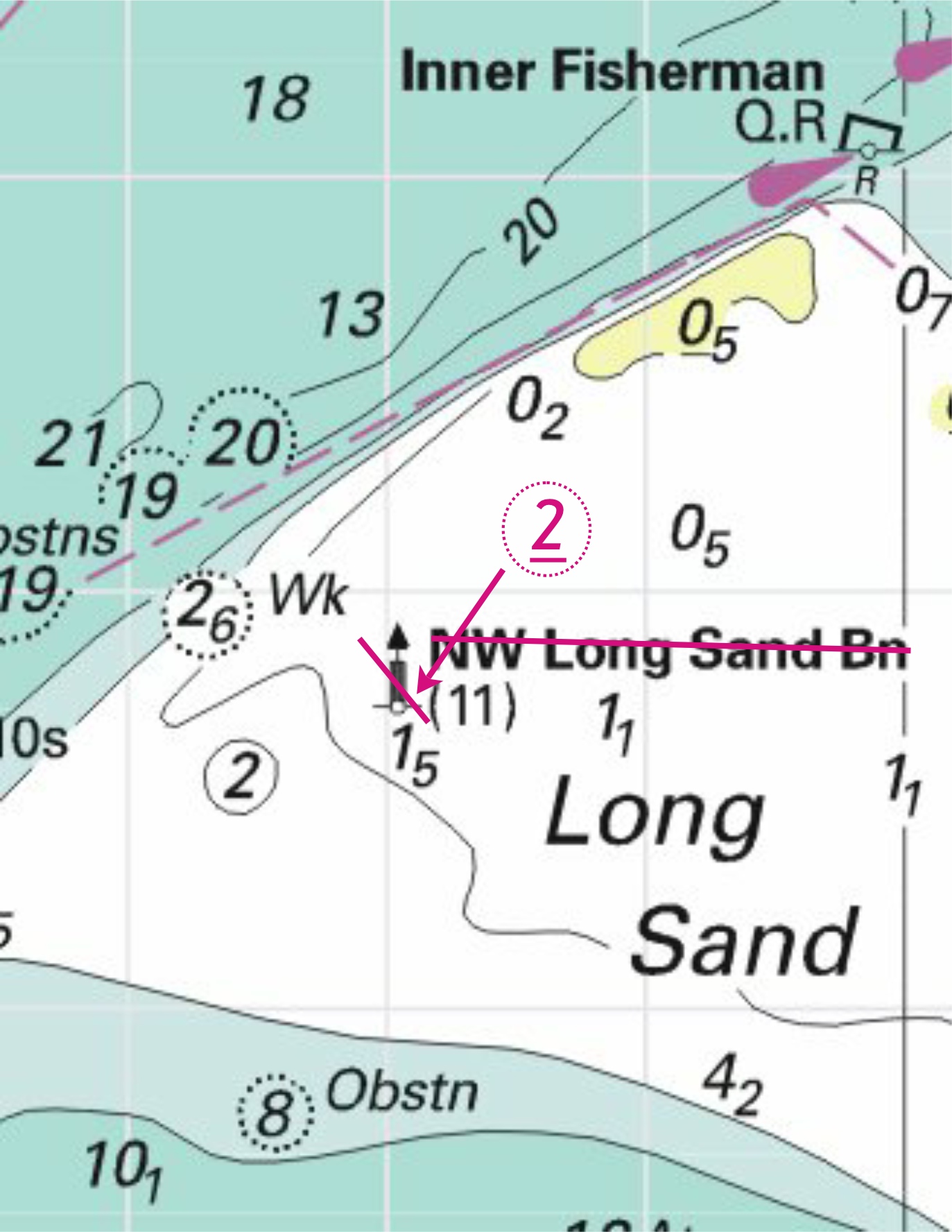
Week 40 |
ENGLAND - Insert: depth, 11.7 at 51° 30´·090N., 0° 31´·913E. Delete depth, 12.3, close E. depth, 12.4 at 51° 30´·078N., 0° 31´·801E. Notice 4441 refers The base image courtesy of Imray ID10 Chart IN5036 and Meridian Chartware.
|
Affects: UKHO SNC: 1186 (Panel A Canvey Island to Coalhouse Point). UKHO SCC: 5606.13. Imray Full Charts: C2 Imray Leisure Folios 2100.3 Two reductions of depth in the southern Yantlet Secondary Channel between the Cliffe Fleet and Tanker port hand buoys. Unlikely to hinder leisure craft.
|
|
Week 36 |
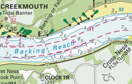
ENGLAND - Insert: depth, 6.5 at 51° 29´·045N., 0° 12´·850E. Delete depth, 6.8, close W. depth, 8.5 at 51° 29´·078N., 0° 12´·884E. depth, 6 at 51° 30´·671N., 0° 05´·778E. Delete depth, 8.2, close NE. depth, 4.1, and extend 5m contour N to enclose 51° 30´·646N., 0° 05´·783E. Delete depth, 7.1, close NW. Replace: depth, 8.4, with depth, 8.2 at 51° 29´·181N., 0° 12´·806E. Notice 4079 refers The base image courtesy of Imray ID10 Chart ON5036 and Meridian Chartware.
|
Affects: UKHO SNC: 2151, 2151 (Panel A, continuation at same scale) and 3337. UKHO SCC: 5607.3 and 5607.2. Imray Full Charts: C2 Imray Leisure Folios 2100.1 Five reduction of depth in the River Thames, two opposite Barking Creek and three opposite Crayford Ness. None likely to hinder leisure craft.
|
|
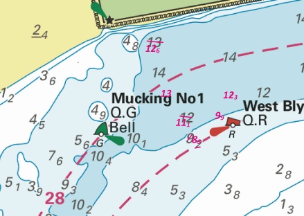
Week 35 |
ENGLAND - Insert: depth, 12.6 at 51° 29´·985N., 0° 28´·380E. Delete depth, 12.8, close N. depth, 13 at 51° 29´·833N., 0° 28´·512E. Delete depth, 13.4, close SW. depth, 11.1 at 51° 29´·743N., 0° 28´·546E. Delete depth, 11.9, close NE and depth, 11.3, close SW. depth, 8.3 at 51° 29´·675N., 0° 28´·611E. Delete depth, 9.2, close NW. depth, 9.9, and extend 10m contour NW to enclose 51° 29´·760N., 0° 28´·731E. Delete depth, 10.2, close SW. depth, 12.3 at 51° 29´·828N., 0° 28´·792E. Delete depth, 12.9, close SW. Notice 4002 refers The base image courtesy of Imray ID10 Chart IN5036 and Meridian Chartware.
|
Affects: UKHO SNC: 1186 (Panel A, Canvey Island to Coalhouse Point) UKHO SCC: 5606.13. Imray Full Charts: C2 Imray Leisure Folios 2100.3. 4 reductions of depth in west end of the Sea Reach by the Mucking No 1 SHB and the West Blyth PHB. None likely to hinder leisure craft.
|
|
Week 33 |
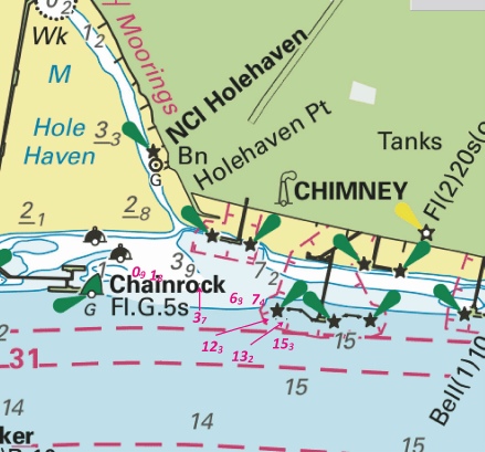
ENGLAND - Insert: depth, 0.8 at 51° 30´·47N., 0° 33´·03E. Delete depth, 0.9, close W. depth, 6.3 at 51° 30´·42N., 0° 33´·35E. Delete depth, 6.1, close W. depth, 15.3 at 51° 30´·334N., 0° 33´·497E. depth, 12.3 at 51° 30´·382N., 0° 33´·469E. depth, 7.4 at 51° 30´·415N., 0° 33´·417E. Delete depth, 8.2, close S. depth, 3.7 at 51° 30´·452N., 0° 33´·223E. Delete depth, 3.9, close W. depth, 1.8 at 51° 30´·469N., 0° 33´·076E. Delete depth, 2, close SW. depth, 7.8 at 51° 29´·485N., 0° 28´·247E. Delete 8.4, close NE. depth, 7.5 at 51° 29´·406N., 0° 28´·132E. Delete depth, 7.6, close S. Replace: depth, 14.1, with depth, 13.2 at 51° 30´·381N., 0° 33´·505E. Notice 3775 refers The base image courtesy of Imray ID10 Chart IN5036 and Meridian Chartware.
|
Affects: UKHO SNC: 1185 and 1186 (Panel A, Canvey Island to Coalhouse Point). UKHO SCC: 5606.8. Imray Full Charts: C2 Imray Leisure Folios 2100.2 and 2100.3 A total of 10 reductions of depth in the Yantlet Reach, two close to the Lower Hope PHB and 8 in and around the Chainrock jetties and the entrance into Hole Haven. The depths at the Lower Hope will not hinder leisure craft but around the entrance of Hole Haven has shoaling.
|
|
Week 30 |
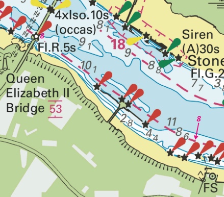
ENGLAND - Insert: sounding out of position, (8) 51° 27´·794N., 0° 15´·448E. Replace: depth, 7.9, with depth, 8 at 51° 27´·355N., 0° 16´·577E. Notice 3474 refers Base image courtesy of Imray ID10 Chart IN5036 and Meridian Chartware.
|
Affects: UKHO SNC: 2151. UKHO SCC: 5606.6, 5606.2, 5607.3 and 5607.2 Imray Full Charts: C2 Imray Leisure Folios 2100.3B. Two new soundings, one reduced, one slightly increased on the south bank of the River Thames just east of the QEII bridge. Unlikely to hinder leisure craft.
|
|
Week 27 |
ENGLAND - Insert: depth, 8.1 at 51° 27´·400N., 0° 26´·387E. Delete depth, 8.8, close SE. Notice 3156 refers Base image courtesy of Imray ID10 Chart IN5036 and Meridian Chartware.
|
Affects: UKHO SNC: 1186 (Panel A, Canvey Island to Coalhouse Point). UKHO SCC: 5607.2 Imray Full Charts: C2 Imray Leisure Folios 2100.3A Notice 1807 in week 16 reported a reduced depth of 8.8m just south of the Ovens SHB in Lower Hope Reach of the River Thames. This notice reports the depth is now 8.1m. But unlikely to hinder leisure craft.
|
|
Week 24 |
ENGLAND - Insert: depth, 12.6 at 51° 29´·40N., 0° 47´·07E. Delete depth, 13.9, close S. depth, 12.4 at 51° 29´·21N., 0° 47´·28E. Delete depth, 13.5, close N. Replace: Notice 2754 refers Base image courtesy of Imray ID10 Chart IN5043 and Meridian Chartware.
|
Affects: UKHO SNC: 1185. UKHO SCC: 5606.7 and 5606.9 Imray Full Charts: C2 Imray Leisure Folios 2100.2 Two reductions of depth in the Yantlet Secondary channels (either side) south of Shoeburyness which are unlikely to hinder leisure craft. Also a wreck already marked in the north side of the Yantlet secondary channel is now swept at 8.2m.
|
|
Week 24 |
ENGLAND - Unexploded ordnance (UXO) have been identified in the Thames Estuary, located in the following positions: 51° 28´·71N., 0° 44´·40E. 51° 28´·71N., 0° 44´·63E. 51° 28´·73N., 0° 44´·63E. * 51° 29´·01N., 0° 49´·20E. Further investigations are planned to determine whether retrieval or disposal of the UXOs is required. Mariners are advised to keep a 100m distance from the UXOs at all times and navigate with caution in the area. Former Notice 2273(T)/24 is cancelled. *Indicates new or revised entry Notice 2704(T) refers Base image courtesy of Imray ID10 Chart IN5037 and Meridian Chartware.
|
Affects: UKHO SNC: 1185 and 3683. UKHO SCC: 5606.7 and 5606.9 Imray Full Charts: C2 Imray Leisure Folios 2100.2 Notice 2273 in week 21 reported three locations of ordnance on the Nore Sand to avoid. Now the notice is repeated with an additional fourth entry, east of the Nore Sand. Note this image together with the previous image in week 21.
|
|
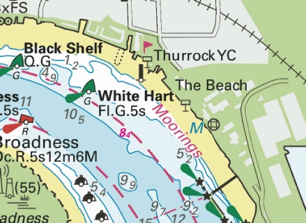
Week 22 |
ENGLAND - Insert: depth, 8.4 at 51° 28´·075N., 0° 19´·343E. Delete depth, 8.7, close SE. Notice 2411 refers Base image courtesy of Imray ID10 Chart IN5036 and Meridian Chartware.
|
Affects: UKHO SNC: 2151. UKHO SCC: 5606.14A Imray Full Charts: C2 Imray Leisure Folios 2100.3B One reduction of depth in the River Thames, Northfield Hope, southeast of the White Hart SHB. Unlikely to hinder leisure craft.
|
|
Week 21 |
ENGLAND - Replace: depth, 12.1, with depth, 11.8 at 51° 30´·267N., 0° 31´·749E. Notice 2215 refers Base image courtesy of Imray ID10 Chart IN5036 and Meridian Chartware.
|
Affects: UKHO SNC: 1186 (Panel A, Canvey Island to Coalhouse Point). UKHO SCC: 5606.5 Imray Full Charts: C2 Imray Leisure Folios 2100.2 On reduction of depth in the inbound Yantlet Secondary Channel off Coryton, River Thames. Ample water unlikely to hinder leisure craft.
|
|
Week 21 |
ENGLAND - Insert: depth, 10.8 at 51° 30´·03N., 0° 36´·42E. Delete depth, 13.1, close NW. depth, 12.4 at 51° 29´·93N., 0° 40´·69E. Delete depth, 13.8, close NW. depth, 14.4 at 51° 29´·95N., 0° 41´·26E. Delete depth, 15.6, close NE. depth, 12.2 at 51° 29´·86N., 0° 41´·52E. Delete depth, 13.6, close N. Notice 2253 refers Base image courtesy of Imray ID10 Chart IN5037 and Meridian Chartware.
|
Affects: UKHO SNC: 1185. UKHO SCC: 5606.8 Imray Full Charts: C2 Imray Leisure Folios 2100.2 Four reductions of depth in the Yantlet Channel, River Thames, one west of the Sea Reach 7 South PHB and the other three between Sea Reach Nos 6 and No 5 South PHBs. All unlikely to hinder leisure craft. Two images.
|
|
Week 21 |
ENGLAND - Insert: depth, 1.6, and extend 2m contour S to enclose 51° 30´·826N., 0° 06´·042E. Delete depth, 2.3, close E.
Notice 2265 refers Base image courtesy of Imray ID10 Chart IN5036 and Meridian Chartware.
|
Affects: UKHO SNC: 2151 (Panel A, continuation at same scale) and 3337. UKHO SCC: 5606.8 Imray Full Charts: C2 Imray Leisure Folios 2100.4A and B One reduction of depth down to 1.6m right at the entrance into Barking Creek, River Thames.
|
|
Week 21 |
ENGLAND - Unexploded ordnance (UXO) have been identified in the Thames Estuary, located in the following positions: 51° 28´·71N., 0° 44´·40E. 51° 28´·71N., 0° 44´·63E. 51° 28´·73N., 0° 44´·63E. Further investigations are planned to determine whether retrieval or disposal of the UXOs is required. Mariners are advised to keep a 100m distance from the UXOs at all times and navigate with caution in the area. Notice 2273(T) refers Base image courtesy of Imray ID10 Chart IN5037 and Meridian Chartware.
|
Affects: UKHO SNC: 1185 and 3683. UKHO SCC: 5606.7. Imray Full Charts: C2 Imray Leisure Folios 2100.2 This temporary Notice is replicating the Port of London Authority local notices in the past two weeks reporting ordnance on the Nore Sands to avoid. There are now three separate ordnance east of the Mid Swatch SHB. Marked on the image. There are clearly on the Sand not the swatchway.
|
|
Week 19 |
ENGLAND - Replace: depth, 0.1, with circular limit of 0m low water line, radius 30m, centred on: 51° 30´·46N., 0° 32´·59E. depth, 2.4, with depth, 0.6, enclosed by 2m contour 51° 30´·451N., 0° 32´·493E. Insert: depth, 7.7, and extend 10m contour S to enclose 51° 30´·407N., 0° 31´·338E. depth, 5.5, and extend 10m contour S to enclose 51° 30´·423N., 0° 31´·498E. depth, 3.5, and extend 5m contour S to enclose 51° 30´·438N., 0° 31´·618E. Delete depth, 4.4, close W. depth, 3.9, enclosed by 5m contour 51° 30´·438N., 0° 31´·690E. depth, 3.4, and extend 5m contour S to enclose 51° 30´·450N., 0° 31´·752E. depth, 8.8 at 51° 30´·422N., 0° 31´·806E. Delete depth, 9.6, close W. depth, 7.3 at 51° 30´·429N., 0° 31´·881E. Delete depth, 7.5, close NE. drying height, 0.8, and extend 0m low water line S to enclose 51° 30´·486N., 0° 31´·986E. Delete depth, 1.1, close W. depth, 9.1, and extend 10m contour S to enclose 51° 30´·429N., 0° 32´·444E. depth, 11.4 at 51° 30´·419N., 0° 32´·618E. Delete depth, 12.2, close W. depth, 0.2, enclosed by 2m contour at 51° 30´·454N., 0° 32´·696E. Delete depth, 5.9, close SE. Notice 2038 refers Base image courtesy of Imray ID10 Chart IN5036 and Meridian Chartware.
|
Affects: UKHO SNC: 1185 and 1186 (INT 1426) (Panel A, Canvey Island to Coalhouse Point) UKHO SCC: 5606.8 Imray Full Charts: C2 Imray Leisure Folios 2100.2 and 2100.3 This notice has 13 reductions of depth of which one is a drying height but all are located in the commercial area alongside the jetties of Shellhaven, Coryton and Chainrock. Illustrating the changes are impractical at the scale available and are unlikely to be anywhere leisure craft should be so for the first time I am breaking my usual practice.
|
|
Week 16 |
ENGLAND - Insert: depth, 8.8, and extend 10m contour SE to enclose 51° 27´·392N., 0° 26´·394E. Delete depth, 8.7, close NW. Notice 1807 refers Base image courtesy of Imray ID10 Chart IN5036 and Meridian Chartware.
|
Affects: UKHO SNC: 1186 (Panel A, Canvey Island to Coalhouse Point). UKHO SCC: 5606.13 (Panel A, Hole Haven to Gravesend Reach) Imray Full Charts: C2 Imray Leisure Folios: 2100.3A An unusual event here; a NtM reporting an increase of depth. One very slight increase of depth in the River Thames in the south end of the Lower Hope Reach just south of the Ovens SHB. Unlikely to hinder leisure craft.
|
|
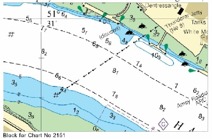
Week 15 |
ENGLAND - Insert: pontoon, single firm line, joining: 51° 30´·271N., 0° 04´·195W. 51° 30´·273N., 0° 04´·192W. 51° 30´·262N., 0° 04´·159W. 51° 30´·259N., 0° 04´·162W. Notice 1648 refers Base image courtesy of Imray Chart IN5030 and Meridian Chartware.
|
Affects: UKHO SNC: 3337. UKHO SCC: 5606.15A Imray Full Charts: C2 Imray Leisure Folios 2100.4B A new pontoon in the River Thames at the Pool, just upstream of the Hermitage Wharf pontoon.
|
|
Week 15 |
ENGLAND - Insert: depth, 3.4 at 51° 31´·036N., 0° 08´·036E. Delete depth, 3.7 , close W. Notice 1655 refers Base image courtesy of Imray ID10 Chart IN5036 and Meridian Chartware.
|
Affects: UKHO SNC: 2151 (Panel A, Continuation at same scale). UKHO SCC: 5606.14B Imray Full Charts: C2 Imray Leisure Folios 2100.4A One reduction of depth in the River Thames, at Horseshoe Corner in Halfway Reach. Unlikely to hinder leisure craft.
|
|
Week 12 |
ENGLAND - Insert: the accompanying block, centred on: 51° 30´·9N., 0° 08´·3E. Notice 1265 refers Block is copyright of the UKHO.
|
Affects: UKHO SNC: 2151 (Panel A, Continuation at same scale). UKHO SCC: 5606.2 and 5607.2 Imray Full Charts: C2 Imray Leisure Folios 2100.4A A new UKHO block for the River Thames, Halfway Reach off Dagenham.
|
|
Week 10 |
ENGLAND - Delete established direction of traffic flow arrow: On SN Chart 1185 direction 266° centred on: 51° 29´·49N., 0° 48´·89E. direction 282° centred on: 51° 29´·63N., 0° 44´·88E. direction 272° centred on: 51° 30´·16N., 0° 39´·51E. and 51° 30´·28N., 0° 34´·74E. direction 089° centred on: 51° 30´·10N., 0° 33´·05E. direction 092° centred on: 51° 29´·95N., 0° 38´·83E. direction 101° centred on: 51° 29´·36N., 0° 45´·12E. direction 086° centred on: 51° 29´·25N., 0° 48´·84E. On SN Chart 1186 (Panel A, Canvey Island to Coalhouse Point) direction 272° centred on: 51° 30´·249N., 0° 36´·121E. and 51° 30´·293N., 0° 34´·396E. direction 267° centred on: 51° 30´·315N., 0° 32´·755E. direction 260° centred on: 51° 30´·262N., 0° 31´·404E. direction 080° centred on: 51° 30´·025N., 0° 31´·585E. direction 090° centred on: 51° 30´·106N., 0° 32´·870E. direction 094° centred on: 51° 30´·047N., 0° 34´·337E. direction 093° centred on: 51° 30´·025N., 0° 36´·083E. On SN Chart 1606 direction 054° centred on: 51° 33´·47N., 1° 10´·06E. and 51° 32´·10N., 1° 07´·42E. direction 234° centred on: 51° 32´·33N., 1° 07´·21E. and 51° 33´·27N., 1° 10´·40E. On SN Chart 1607 direction 267° centred on: 51° 29´·61N., 0° 52´·37E. direction 086° centred on: 51° 29´·33N., 0° 51´·91E. On SN Chart 1609 direction 234° centred on: 51° 33´·47N., 1° 10´·07E. and 51° 32´·32N., 1° 07´·21E. direction 266° centred on: 51° 29´·56N., 0° 51´·42E. direction 088° centred on: 51° 29´·34N., 0° 51´·18E. direction 055° centred on: 51° 32´·08N., 1° 07´·42E. and 51° 33´·27N., 1° 10´·39E. On SC Chart 5606.7 direction 266° centred on: 51° 29´·49N., 0° 48´·89E. direction 282° centred on: 51° 29´·63N., 0° 44´·88E. direction 102° centred on: 51° 29´·36N., 0° 45´·12E. direction 086° centred on: 51° 29´·25N., 0° 48´·84E. On SC Chart 5606.8 direction 272° centred on: 51° 30´·16N., 0° 39´·51E. and 51° 30´·28N., 0° 34´·74E. direction 089° centred on: 51° 30´·10N., 0° 33´·05E. direction 092° centred on: 51° 29´·95N., 0° 38´·83E. On SC Chart 5606.9 direction 266° centred on: 51° 29´·49N., 0° 48´·90E. direction 282° centred on: 51° 29´·63N., 0° 44´·88E. direction 102° centred on: 51° 29´·36N., 0° 45´·12E. direction 086° centred on: 51° 29´·25N., 0° 48´·84E. On SC Chart 5606.5 direction 267° centred on: 51° 29´·61N., 0° 52´·37E. direction 086° centred on: 51° 29´·33N., 0° 51´·91E. Notice 1106 refers |
Affects: UKHO SNC: 1185, 1186 (Panel A, Canvey Island to Coalhouse Point), 1606, 1607 and 1609. UKHO SCC: 5606.7, 5606.8, 5606.9 and 5606.5 Imray Full Charts: C2 and C1 Imray Leisure Folios 2100.2 and 2100.1 This Notice deletes a total of 42 established direction of traffic flow arrows in the Sea Reach of the River Thames and the Outer Thames. This affects detailed 5 SN charts and 4 SC charts. If the Speaker can break conventions so can I, so I have not illustrated the changes on the grounds that this does not affect leisure craft.
|
|
Week 08 |
ENGLAND - Delete:
51° 29´·942N., 0° 02´·962E. 51° 29´·177N., 0° 00´·103W. 51° 29´·157N., 0° 00´·142W. Notice 873 refers Base image courtesy of Imray ID10 Chart IN5030 and Meridian Chartware.
|
Affects: UKHO SNC: 3337 UKHO SCC: None Old UKHO Leisure Folio: 5606.13 (Panel A, Hole Haven to Gravesend Reach) and 5606.15 (Panel A, Hook Ness to Tower Bridge) Imray Full Charts: C2 Imray Leisure Folios: 2000.4 (Panel B Tower Bridge to Barking Creek) Deletion of three shore based lights alongside in the River Thames: one at jetty of the Thames Refinery just east of the Thames Barrier, two also deleted at the jetty off the Greenwich Power Station.
|
|
Week 07 |
ENGLAND - Replace depth, 1.9, with depth, 0.7 at 51° 29´·931N., 0° 02´·973E. Notice 643 refers Base image courtesy of Imray ID10 Chart IN5030 and Meridian Chartware.
|
Affects: UKHO SNC: 3337 UKHO SCC: 5606.13 (Panel A, Hole Haven to Gravesend Reach) Imray Full Charts: C2 Imray Leisure Folios: 2100.3A Significant reduction of depth right by the jetty off the Thames Refinery on the North Woodwich bank of the River Thames. Not likely to hinder leisure there!
|
|
Week 07 |
ENGLAND - Insert: depth, 4.9, and extend 5m contour W to enclose 51° 27´·906N., 0° 27´·284E. Delete depth, 7.2, close SW. Notice 646 refers Base image courtesy of Imray ID10 Chart IN5036 and Meridian Chartware.
|
Affects: UKHO SNC: 1186 (Panel A, Canvey Island to Coalhouse Point). UKHO SCC: 5606.13 (Panel A, Hole Haven to Gravesend Reach) Imray Full Charts: C2 Imray Leisure Folios: 2100.3A A significant reduction of depth close by the north end of the pontoon off Cliffe Fort, River Thames, Lower Hope Reach . Unlikely to hinder leisure craft.
|
|
Week 06 |
ENGLAND - Source: Port of London Authority Works are in progress at London Gateway Container Terminal, in an area bounded by the following positions: 51° 30´·228N., 0° 28´·060E. 51° 30´·072N., 0° 28´·114E. 51° 30´·196N., 0° 29´·233E. 51° 30´·158N., 0° 29´·243E. 51° 30´·162N., 0° 29´·298E. 51° 30´·090N., 0° 29´·320E. 51° 29´·938N., 0° 27´·979E. 51° 30´·217N., 0° 27´·873E. 51° 30´·237N., 0° 28´·016E. 51° 30´·229N., 0° 28´·022E. 51° 30´·226N., 0° 28´·028E. 51° 30´·224N., 0° 28´·029E. 51° 30´·222N., 0° 28´·038E. Mariners are advised to navigate with caution in the area. Former Notice 1496(T)/23 is cancelled. Notice 515(T) refers Base image courtesy of Imray ID10 Chart IN5036 and Meridian Chartware.
|
Affects: UKHO SNC: 1185 and 1186 UKHO SCC: 5606.13 (Panel A, Hole Haven to Gravesend Reach) Imray Full Charts: C2 Imray Leisure Folios: 2100.3A Long term temporary notice warning of the extension of the Thames Gateway Terminal – west side of the existing terminal and we are recommended to be on the other side of the River.
|
|
Week 04 |
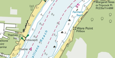
ENGLAND - Insert:
Delete pontoon and associated legend, Pontoon, close NW of 51° 27´·496N., 0° 16´·031E. Notice 345 refers Base image courtesy of Imray ID10 Chart IN5036 and Meridian Chartware.
|
Affects: UKHO SNC: 2151 UKHO SCC: 5606.14 (Panel A Gravesend Reach to Erith Reach) Imray Full Charts: C2 Imray Leisure Folios: 2100.3 New dolphin installed instead of a former pontoon on the south bank of the River Thames in Long Reach east of the QEII bridge. Solely a commercial dolphin.
|
|
Week 03 |
ENGLAND - Insert: depth, 3 at 51° 29´·354N., 0° 11´·001E. Delete depth, 3.8, close NW. Notice 198 refers Base image courtesy of Imray ID10 Chart IN5036 and Meridian Chartware.
|
Affects: UKHO SNC: 2151 (Panel A, continuation at the same scale) UKHO SCC: 5606.14 (Panel A) Imray Full Charts: C2 Imray Leisure Folios: 2100.4A One reduction of depth in the River Thames, Erith Reach right by the downside of the wharf/pontoon off Rainham Marshes. Unlikely to hinder leisure craft.
|
|
Week 03 |
ENGLAND - Insert: depth, 13.8 at 51° 30´·06N., 0° 39´·49E. Delete depth, 14, close W. Notice 203 refers Base image courtesy of Imray ID10 Chart IN5036 and Meridian Chartware.
|
Affects: UKHO SNC: 1185 UKHO SCC: 5606.8 Imray Full Charts: C1 Imray Leisure Folios: 2100.2 One reduction of depth right in the middle of the Yantlet channel, River Thames east of the recommended small craft crossing transit. Not where we ought to be or likely to hinder leisure craft.
|
|
Week 02 |
ENGLAND - Insert: depth, 8.3 at 51° 30´·411N., 0° 10´·121E. Delete depth, 8.4, close W. depth, 6.7 at 51° 30´·331N., 0° 10´·123E. depth, 5.7 at 51° 30´·319N., 0° 10´·109E. Delete depth, 6.1, close W. depth, 8.3 at 51° 30´·305N., 0° 10´·207E. depth, 6.7 at 51° 30´·340N., 0° 10´·311E. depth, 6 at 51° 30´·278N., 0° 10´·192E. Delete depth, 6.1, close SE. depth, 4.5, and extend 5m contour NE to enclose 51° 30´·192N., 0° 10´·334E. Delete depth, 4.7, close NW. depth, 6.7 at 51° 30´·205N., 0° 10´·350E. depth, 9 at 51° 30´·202N., 0° 10´·414E. Delete depth, 9.3, close SW. Notice 111 refers Base image courtesy of Imray ID10 Chart IN5036 and Meridian Chartware.
|
Affects: UKHO SNC: 2151 (Panel A, continuation at the same scale) UKHO SCC: 5606.14 (Panel A) Imray Full Charts: C2 Imray Leisure Folios: 2100.4 A cluster of 9 reductions of depth in the River Thames in Erith Reach off Jenningtree Point. Unlikely to hinder leisure craft.
|
 at:
at:


 Unexploded Ordnances (2024)
  at 51° 28´·67N., 0° 44´·15E.
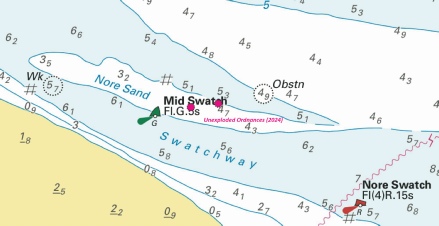

 at:
at: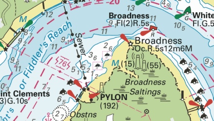
 with
with  at 51° 29´·74N., 0° 44´·02E.
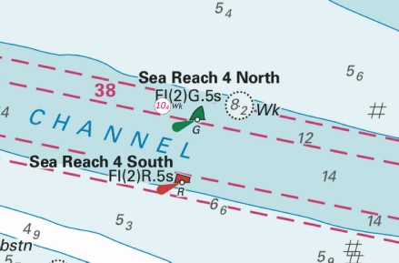


 at 51° 29´·73N., 0° 44´·39E.
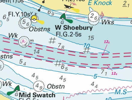
%2024.jpg)


.jpg)


 at
at 


.jpg)
 at 51° 27´·496N., 0° 16´·031E.


