|
Notices - |
||
|
Week 15 |
New Editions of ADMIRALTY Small Craft Charts to be published on 24th April, 2025 SC Chart 5606.7 Havengore Bridge to Southend- SC Chart 5606.8 Southend- SC Chart 5606.9 Medway Approach Channel. 1:25,000 SC Chart 5606_10 A. Mouth of River Medway and West Swale. 1:25,000 B Ferry Reach. 1:12,500 C Ramsgate. 1:5,000 |
|
|
Week 13 |
ENGLAND - Submarine cable laying works are taking place between North Foreland and Oostende, along a line joining the following positions: 51° 22´·73N., 1° 26´·80E. 51° 23´·45N., 1° 29´·81E. 51° 23´·15N., 1° 32´·74E. 51° 23´·55N., 1° 33´·52E. 51° 23´·55N., 1° 36´·37E. 51° 23´·75N., 1° 38´·91E. 51° 22´·61N., 1° 43´·78E. 51° 22´·72N., 1° 45´·28E. 51° 22´·45N., 1° 48´·39E. 51° 22´·53N., 2° 03´·45E. 51° 22´·63N., 2° 06´·71E. 51° 22´·36N., 2° 08´·59E. 51° 22´·53N., 2° 12´·70E. 51° 21´·80N., 2° 14´·73E. 51° 21´·37N., 2° 17´·93E. 51° 21´·59N., 2° 22´·00E. 51° 22´·47N., 2° 27´·09E. 51° 22´·27N., 2° 28´·42E. 51° 22´·23N., 2° 32´·09E. 51° 21´·27N., 2° 33´·95E. 51° 20´·89N., 2° 40´·56E. 51° 21´·28N., 2° 41´·97E. 51° 21´·00N., 2° 44´·40E. 51° 17´·38N., 2° 47´·99E. 51° 13´·57N., 2° 53´·85E. Charts will be updated when works are complete. This change will be included in a New Edition of Chart 1607. Mariners are advised to navigate with caution in the area. Notice 1339(P) refers Base image is from Imray chart C30 by courtesy of Imray and Meridian Chartware.
|
Affects: UKHO SNC: 323, 1183, 1406, 1610, 1630, 1828 and 2449. Belgium SNC: BE11 and BE102 UKHO SCC: 5605.1, 5605.11, 5606.1, 5606.2, 5606.4 and 5607.1. Imray Full Charts: C30 A submarine cable between North Foreland and the Oostende is to be laid pretty much west to east until off Oostende. No doubt there will be VHF broadcasts when working.
|
|
Week 12 |
ENGLAND - Insert:
51° 29´·01N., 0° 49´·20E. 51° 28´·72N., 0° 44´·63E. 51° 28´·71N., 0° 44´·40E. 51° 30´·11N., 1° 02´·41E. 51° 28´·71N., 0° 56´·60E. 51° 28´·72N., 0° 56´·41E. 51° 28´·80N., 0° 55´·11E.
Notice 1295 refers Base images are from Imray chart IN5037 and 5043 by courtesy of Imray and Meridian Chartware.
|
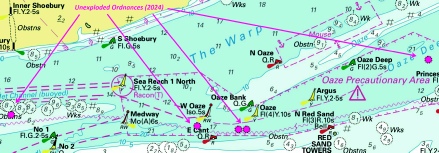
Affects: UKHO SNC: 1185, 1609 and 3683. Note: Former Notice 2704(T)/24 is cancelled. This update is included in New Edition 1607, published early 2024. UKHO SCC: 5606.7, 5606.9 and 5606.5 Imray Full Charts: C1 Imray Leisure Folios: 2100.2 Last year, following survey work for a new cable laying, unexploded ordnance was discovered – almost a single line of ordnance -
|
|
Week 10 |
New Editions of ADMIRALTY Charts to be published on 20th March, 2025 SN Chart 1607 International Chart Series, England - SN Chart 1975 England - SN Chart 2052 International Chart Series, England - SN Chart 2692 England - |
Charts 1607 and 1975 are important charts for us as these are followd by the echart makers. |
|
Week 8 |
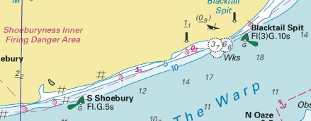
ENGLAND - Insert: drying height, 0.2, and extend 0m contour S to enclose 51° 31´·33N., 0° 55´·40E. depth, 1.6, and extend 2m contour S to enclose 51° 30´·99N., 0° 53´·93E. Delete depth, 1.2, close W drying height, 0.9, and extend 0m contour S to enclose 51° 58´·78N., 1° 23´·79E. Delete drying height, 0.9, close NW. Notice 907 refers Base images are from Imray Chart IN5043 by courtesy of Imray, Admiralty Chart 2693 and Meridian Chartware.
© Crown Copyright and/or database rights. Reproduced by permission of The Keeper of Public Records and the UK Hydrographic Office (www.GOV.uk/UKHO). |
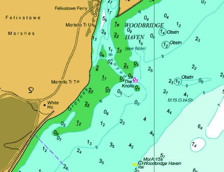
Affects: UKHO SNC: 1607. Note: These updates are included in New Editions 1185, 1609 and 2693 published early 2025. UKHO SCC: 5606.7, 5606.5, 5606.6 and 5706.6 (Panel A, Approaches to Harwich and Woodbridge Haven) Imray Full Charts: C1 and Y16 Imray Leisure Folios: 2100.2 and 2000.3 A bit unusual: three reductions of depth/new drying heights. Two on the edge of Blacktail Spit (off Shoeburyness) between the South Shoebury SHB and the Blacktail Spit SHB and one drying height at the Deben Entrance. I notice the source is from the Environment Agency NOT from Trinity House. I suspect this might not be immediately recent and we should wait for the details from Trinity House which will be announced by East Coast Pilot as soon as they have the new chartlet. Note the image at the Deben will be out of date, it is merely used to show where the drying height is recorded.
|
|
Week 7 |
New Editions of ADMIRALTY Charts to be published on 27th February, 2025 SN Chart 1185 - Continuation of Hole Haven Creek. 1:25,000 SN Chart 1606 - SN Chart 1609 - SN Chart 2693 - A Continuation of River Stour. 1:25,000 B Ipswich. 1:20,000 C Continuation of River Deben. 1:25,000 SN Chart 3683 - Sheerness. 1:6,250 |
|
|
Week 5 |
ENGLAND - Insert: depth, 11.1 at 51° 29´·30N., 0° 52´·89E. Delete depth, 12.1, close N. Notice 398 refers Base image is from Imray chart IN5043 by courtesy of Imray and Meridian Chartware.
|
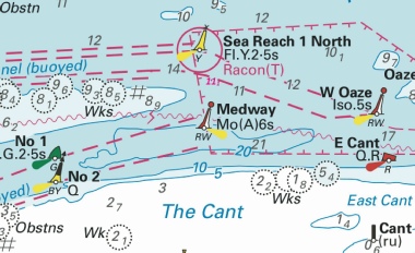
Affects: UKHO SNC: 1607 and 1609. UKHO SCC: 5606.5. Imray Full Charts: C1 Imray Leisure Charts: 2100.1 and 2100.2 One reduction of depth just south of the Sea Reach No 1 yellow special lit buoy. Ample water for leisure craft.
|
|
SCROLL DOWN FOR 2024 NOTICES |
||
|
Week 52 |
ENGLAND - Insert:
Notice 5883 refers The base image courtesy of Imray Chart IN5037 and Meridian Chartware.
|
Affects: UKHO SNC: 1185. UKHO SCC: 5606.7 Imray Full Charts: C2 Imray Leisure Charts: C2100.2 and C2100.1 One new FOUL (position approximate) reported in 2024 has been found in the Southend Deep Water Anchorage in Sea Reach, River Thames. Unlikely to hinder leisure craft.
|
|
Week 52 |
ENGLAND - The starboard- Former Position New Position 51° 28´·67N., 0° 44´·15E. 51° 28´·87N., 0° 43´·32E. Mariners are advised to navigate with caution in the area. Notice 5855(T) refers The base image courtesy of Imray Chart IN5037 and Meridian Chartware.
|
Affects: UKHO SNC: 1185 and 3683. UKHO SCC: 5606.7, 5606.8 and 5606.9 Imray Full Charts: C2 Imray Leisure Charts: C2100.2 and C2100.1 The Mid Swatch starboard hand buoy marking the south side of the Nore Sand has been moved approx. 0.6nm 290°(T). Worth noting.
|
|
Week 48 |
DOVER STRAIT - Insert: depth, 28.5 at 51° 08´·18N., 1° 40´·06E. Delete depth, 29.5, close N. depth, 27 at 51° 08´·55N., 1° 40´·91E. Delete depth, 28.5, close N. depth, 27.5 at 51° 13´·50N., 1° 44´·41E. Delete depth, 28.5, close N. Replace: depth, 28, with depth, 27 at 51° 09´·49N., 1° 41´·36E. depth, 26.5, with depth, 25.5 at 1° 08´·37N., 1° 40´·35E and delete depth, 27.5, close NW. Notice 5368 refers The base image courtesy of Imray Chart IN5007 and Meridian Chartware.
|
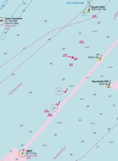
Affects: UKHO SNC: 323, 1406, 1610, 1892 and 2449. UKHO SCC: 5605.2, 5605.1 (Panel B, Approaches to Dover Straits) and 5606.1. Note: This update is included in New Edition 5606.3, published late 2024. Imray Full Charts: C8 Imray Leisure Folios 2100.1 Five reductions of depth in the SW going TSS twixt the South Falls south cardinal buoy and the MPC yellow special buoy. Very unlikely to hinder leisure craft at those depths! The image includes three other reduced depths reported in NtM 5161 in week 45.
|
|
Week 47 |
ENGLAND - Replace:
Notice 5296 refers The base image courtesy of Imray Chart IN5016 and Meridian Chartware.
|
Affects: UKHO SNC: 1185, 1834, 2482 and 3683. UKHO SCC: 5606.10 (Panel A, Mouth of River Medway and West Swale) and 5606.9. Imray Full Charts: Y18 Imray Leisure Folios 2100.3 and 2100.5 This notice confirms the Medway (ABP Ports) notice of the removal of the two ships moorings (Nos 1 and 2) west of Queenborough Spit and inserting two FOUL in place. The Medway notice reported that the old mooring chains had been left in place, hence the two FOUL.
|
|
Week 47 |
ENGLAND - Insert: depth, 2.5, and extend 5m contour S to enclose 51° 23´·99N., 1° 19´·34E. Replace:
depth, 1.8, with depth, 0.5 at 51° 24´·12N., 1° 13´·62E. Notice 5330 refers The base image courtesy of Imray Chart C1 and Meridian Chartware.
|
Affects: UKHO SNC: 323, 1183, 1607 and 1828. UKHO SCC: 5606.4 and 5606.2. Imray Full Charts: C1 Imray Leisure Folios 2100.1 and 2100.7 This Notice confirms Preliminary Notice 4581(P) earlier this year reporting a reduction of depth over an existing wreck and two depths on the south side of the Margate Hook.
|
|
Week 46 |
ENGLAND - Insert:
Notice 5235 refers The base image courtesy of Imray Chart IN5035 and Meridian Chartware.
|
Affects: UKHO SNC: 1185 and 3683. UKHO SCC: 5606.9 and 5606.10 (Panel A, Mouth of River Medway and West Swale). Imray Full Charts: C1 Imray Leisure Folios 2100.2 A new ‘obstn’ (at 2.9m) reported a little due west of the wreck of the SS Montgomery.
|
|
Week 46 |
ENGLAND - Insert depth, 5, and extend 5m contour SW to enclose 51° 32´·03N., 1° 00´·15E. Delete depth, 5.4, close SW. depth, 0.7, and extend 2m contour S to enclose 51° 32´·41N., 1° 01´·45E. Delete depth, 2.7, close SE and depth 1.2 close NE. depth, 1.6, and extend 2m contour S to enclose 51° 32´·44N., 1° 01´·59E. Delete depth, 2.7, close E and depth, 0.1, close NW.
Replace: depth, 5.5, with depth, 4.8, and extend 5m contour S to enclose 51° 32´·34N., 1° 01´·23E. Notice 5252 refers The base image courtesy of Imray Chart IN5043 and Meridian Chartware.
|
Affects: UKHO SNC: 1607 and 1609 UKHO SCC: 5606.6. Imray Full Charts: C1 Imray Leisure Folios 2100.1 This notice reports three reductions of depths close to the SW Barrow west cardinal buoy. We had an earlier Notice this year (1608) in week 15 and this notice amends some of those reductions. The message is that it is not good to cut inside the cardinal buoy to or from the West Swin without due regard.
|
|
Week 45 |
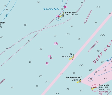
DOVER STRAIT - Insert: depth, 18.9, and extend 20m contour SE to enclose 51° 14´·39N., 1° 44´·21E. depth, 18.5 at 51° 13´·79N., 1° 43´·52E. Delete depth, 19.5, close S. depth, 22. 5 at 51° 11´·27N., 1° 42´·72E. depth, 25 at 51° 10´·88N., 1° 42´·38E. Delete depth, 26.5, close NW. Replace: depth, 23.5, with depth, 22.5 at 51° 12´·13N., 1° 43´·29E. Notice 5161 refers The base image courtesy of Imray Chart IN5007 and Meridian Chartware.
|
Affects: UKHO SNC: 323, 1406, 1610 and 2449. UKHO SCC: 5605.2, 5605.1 (Panel B, Northern Approaches to Dover Strait), 5606.3 and 5606.1. Imray Full Charts: C8 Imray Leisure Folios 2100.1 Five reductions of depth in the SW bound TSS between the South Falls NCB and the F1 Special buoy. Very unlikely to hinder leisure craft!
|
|
Week 44 |
ENGLAND - Insert: depth, 5.9 at 51° 19´·075N., 1° 32´·216E. depth, 4.8, enclosed by 5m contour 51° 18´·747N., 1° 32´·009E. depth, 0.1, and extend 2m contour NW to enclose 51° 18´·50N., 1° 31´·19E. depth, 1.6, and extend 2m contour NW to enclose 51° 18´·60N., 1° 31´·66E. Delete depth, 6.1, close NE. depth, 5.9 at 51° 19´·08N., 1° 32´·22E. Delete depth, 7.6, close SW. depth, 0.7, and extend 2m contour NE to enclose 51° 18´·58N., 1° 32´·33E. Delete depth, 3, close SW. Notice 5037 refers The base image courtesy of Imray ID10 Chart IN5007 and Meridian Chartware.
|
Affects: UKHO SNC: 1827 (Panel A, Approaches to Ramsgate) and 1828. Note: Former Notice 4121(P)/24 is cancelled. UKHO SCC: 5605.9. Imray Full Charts: Y18 Imray Leisure Folios 2100.7 In week 36, a preliminary notice reported reduced depths between the Goodwin Knoll and the North Sand Head. This permanent notice has cancelled the earlier notice and provided new values on the five reduced depths. Not the place to go!
|
|
Week 43 |
ENGLAND - The mooring buoy in position 51° 25´·470N., 0° 41´·978E. has been replaced by an orange marker buoy until further notice. Mariners are advised to navigate with caution in the area. Notice 4799(T) refers The base image courtesy of Imray ID10 Chart IN5016 and Meridian Chartware.
|
Affects: UKHO SNC: 1185, 1834 and 2482. UKHO SCC: 5606.10 and 5606.11. Imray Full Charts: Y18 Imray Leisure Folios 2100.5 A temporary notice following Medway’s Local notice no 10 of 2024. Ship’s mooring No 11 has been removed and an unlit orange marker in place until further notice. Mooring No 11 effectively marked the eastern entrance of the Stangate Creek. Note that Medway local notice 54 of 2024 reported that Nos 1 and 2 had been removed and the chains lowered permanently to the seabed as ‘FOUL’.
|
|
Week 43 |
ENGLAND - Land reclamation is taking place in the Wick Channel, the Tidal Basin, and Granville Docks as currently depicted by the prohibited area on the chart, centred on 51° 07´·068N., 1° 18´·693E. Charted Aids to Navigation in the reclaimed area have been decommissioned. Harbour Works are taking place in the vicinity of the Cruise Terminal 1 (CT1) (51° 06´·783N., 1° 19´·004E.) and Western Docks 5 (WD5) ( 51° 06´·939N., 1° 19´·043E.) berths. A floating pipeline is established in the Inner Harbour from berth WD5, which will be moved by a workboat to facilitate authorised vessels berthing on WD5. Floating pipeline works are due for completion by mid November 2024. See Notice to Mariners issued by Dover Harbour Board (https://doverportal.portlink.co/home) for the latest information. Charts will be updated when works are complete. Notice 4807(P) refers The base image courtesy of Dover Harbour Board.
|
Affects: UKHO SNC: 1698. UKHO SCC: 5605.14 Imray Full Charts: C8 Imray Leisure Folios 2100.11C This preliminary notice is confirming local Dover notices about the land reclamation of the Wick Channel, the Granville Docks and Tidal Basin. The Dover local notice image best illustrates the area:
|
|
Week 41 |
ENGLAND - Recent survey information has shown that depths less than charted exist within the vicinity of Margate Sand. The most significant are as follows: Depth Position 1·3m 51° 24´·13N., 1° 17´·34E. 0·4m 51° 24´·15N., 1° 13´·60E. The least depth over the wreck in position 51° 24´·09N., 1° 21´·96E. is reported to be 7·2m. Mariners are advised to navigate with caution in the area. Charts will be updated when full details are available. Former Notice 3054(P)/24 is cancelled. Notice 4581(P) refers The base image courtesy of Imray ID10 Chart C1 and Meridian Chartware.
|
Affects: UKHO SNC: 323, 1183, 1607 and 1828. UKHO SCC: 5606.2, 5606.4 and 5606.5. Imray Full Charts: C1 Imray Leisure Folios 2100.1 This preliminary notice is updating an early preliminary NtM (3054(P)/24 in week 27). The earlier notice reported two reduced depths on the south side of the Margate Hook (out of the way of the Gore Channel) but now adds a wreck east of the SE Margate cardinal buoy. At 7.2m, unlikely to hinder leisure craft – unless anchoring of course!
|
|
Week 41 |
ENGLAND - Insert: 5m contour, joining: 51° 27´·97N., 0° 49´·35E (a). 51° 28´·00N., 0° 49´·41E. 51° 28´·01N., 0° 49´·44E. 51° 28´·02N., 0° 49´·48E. 51° 28´·02N., 0° 49´·53E. 51° 28´·01N., 0° 49´·65E (b). Delete: former 5m contour, joining: (a)- depth, 5.3 at 51° 27´·98N., 0° 49´·44E. depth, 14.6, and extend 15m contour NW to enclose 51° 26´·969N., 0° 44´·779E. Delete depth, 16, close N and depth, 14.5, close NE. depth, 10.9 at 51° 27´·952N., 0° 48´·092E. Delete depth, 12.3, close NE and depth, 11.6, close SW. depth, 8.9 at 51° 28´·036N., 0° 49´·255E. Delete depth, 9.6, close NE. depth, 5, enclosed by 5m contour at 51° 28´·007N., 0° 49´·474E. Delete depth, 5.3, close SW. Notice 4608 refers The base image courtesy of Imray ID10 Chart IN5037 and Meridian Chartware.
|
Affects: UKHO SNC: 1185, 3683 (Panel, Sheerness) and 3683. UKHO SCC: 5606.9 and 5606.10 (Panel A, Mouth of River Medway and West Swale). Imray Full Charts: C1 Imray Leisure Folios 2100.1, 2100.2 and 2100.5 5 reduced depths in the Medway Approach Channel and the Secondary Channel which includes a significant contour adjustment of 5m. All reduced depths are in excess of 5m so leisure craft are unlikely to be hindered.
|
|
Week 40 |
ENGLAND - Insert depth, 2, enclosed by 2m contour at 51° 19´·541N., 1° 24´·941E. Delete depth, 3.1, close NW. depth, 2, enclosed by 2m contour at 51° 19´·570N., 1° 25´·053E. Delete depth, 2.5, close SE and depth, 3.2, close NW. depth, 1.7, enclosed by 2m contour at 51° 19´·565N., 1° 25´·222E. Delete depth, 3.1, close N. depth, 2.4 at 51° 19´·553N., 1° 25´·308E. Delete depth, 3.3, close S and depth 3.6, close E. depth, 4.6, and extend 5m contour SE to enclose 51° 19´·520N., 1° 25´·551E. Delete depth, 6.4, close S. depth, 5.6, at 51° 19´·490N., 1° 25´·510E. Delete depth, 7.1, close SE. Notice 4470 refers The base image courtesy of Imray ID10 Chart IN5015 and Meridian Chartware.
|
Affects: UKHO SNC: 1827 (Panel C, Ramsgate) and 1828 (Panel, Ramsgate). UKHO SCC: 5605.15 (Panel B, Ramsgate) and 5606.10 (Panel C, Ramsgate). Imray Full Charts: C8F Imray Leisure Folios 2100.11A (Ramsgate) 6 reductions of depth in the outer harbour of Ramsgate. There have been two earlier NtMs (Nos 1029 and 1999) notifying similar reductions of depth so this image includes all.
|
|
Week 38 |
ENGLAND - Note: Former Notice 2588(P)/24 is cancelled. Insert:
outfall, 51° 22´·00N., 1° 03´·85E. 51° 22´·49N., 1° 03´·90E. Notice 4320 refers The base image courtesy of Imray ID10 Chart IN5037 and Meridian Chartware.
|
Affects: UKHO SNC: 1183 and 1607. UKHO SCC: 5606.5 and 5606.2. Imray Full Charts: C1 Imray Leisure Folios 2100.1 and 2100.6 Earlier this year we had a temporary notice advising us of Outfall works in Tankerton Bay just east of the NCI post. The temporary notice is now cancelled (including two yellow buoys) replaced with a red cone shaped buoy (!) (unlit) which moves a previous such buoy further out north with associated longer outfalls.
|
|
Week 38 |
ENGLAND - Note: This update is included in New Edition 323, published 19 September 2024. Insert: depth,5.1 at 51° 14´·96N., 1° 27´·40E. Delete depth,5.4, close E. depth, 6.1 , and extend 10m contour W to enclose 51° 17´·49N., 1° 29´·81E. Delete depth,11.3 , close S. depth, 0.2 at 51° 18´·13N., 1° 30´·61E. Notice 4324 refers The base image courtesy of Imray ID10 Chart IN5007 and Meridian Chartware.
|
Affects: UKHO SNC: 1828. UKHO SCC: 5605.9 and 5606.3. Imray Full Charts: C8 Imray Leisure Folios 2100.17 Three new reductions of depth on the east side of the Gull Stream. In week 36 we had a preliminary notice of reduced depths in the area; all reductions are included in the one image.
|
|
Week 37 |
ENGLAND - Insert: limit of restricted area, 51° 06´·717N., 1° 19´·440E. 51° 06´·842N., 1° 19´·381E. legend, Entry Restricted (see Note), centred on: 51° 06´·820N., 1° 19´·150E. limit of restricted area, entry prohibited, pecked line, joining: 51° 06´·890N., 1° 18´·948E. 51° 06´·897N., 1° 18´·923E. symbol, entry prohibited: 51° 06´·919N., 1° 18´·928E. 51° 07´·009N., 1° 18´·707E. 51° 07´·077N., 1° 18´·591E. 51° 07´·139N., 1° 18´·674E. the accompanying note, ENTRY RESTRICTED, centred on: 51° 07´·217N., 1° 17´·975E. Notice 4212 refers The image is copyright of the Dover Harbour Board.
|
Affects: UKHO SNC: 1698. UKHO SCC: 5605.14 (Panel A, Dover) Imray Full Charts: C8A Imray Leisure Folios 2100.11C This notice shows the restricted area of the Wick Channel and Basins which is being reclaimed. The best image is the Dover Harbour image:
|
|
Week 37 |
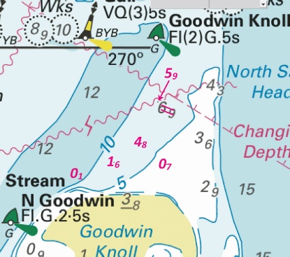
ENGLAND - Recent survey information has shown that numerous depths less than charted exist between Goodwin Knoll and North Sand Head. The most significant are as follows: Depth and Position 4·4m at 51° 18´·65N., 1° 31´·65E. 1·1m at 51° 18´·61N., 1° 31´·83E. 1·2m at 51° 18´·60N., 1° 32´·28E. 8·2m at 51° 19´·789N., 1° 32´·205E. 8m at 51° 19´·823N., 1° 32´·036E. 8·2m at 51° 17´·22N., 1° 29´·63E. 1·3m at 51° 18´·06N., 1° 30´·47E. A drying patch exists in position 51° 18´·50N., 1° 31´·19E. Mariners are advised to navigate with caution in the area. Charts will be updated when full details are available. Notice 4121(P) refers The base image courtesy of Imray ID10 Chart ON5007 and Meridian Chartware.
|
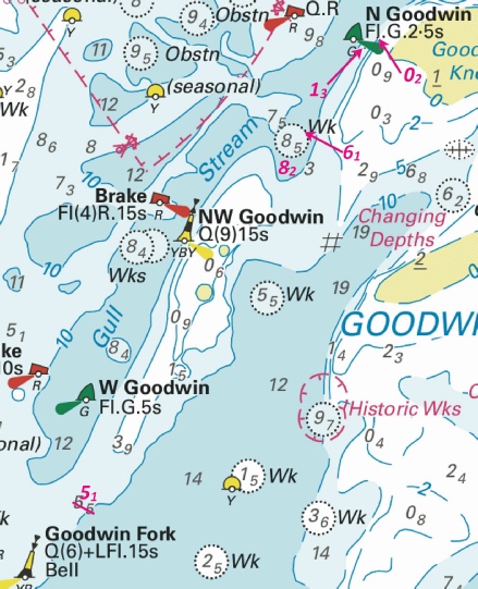
Affects: UKHO SNC: 323, 1827 and 1828. UKHO SCC: 5605.9 and 5606.3. Imray Full Charts: C8 Imray Leisure Folios 2100.7 A preliminary Notice warning of reduced depths on and around the Goodwin Sands: two reductions just north of the Goodwin Knoll SHB (unlikely to hinder leisure craft), three on the north edge of the Goodwin Knoll, one just east of the North Goodwin SHB and one in the Gull Stream north of the NW Goodwin. Most important is a new drying patch on the east side of the Gull Stream north of the North Goodwin SHB – illustrated by a dotted circle.
|
|
Week 36 |
New Editions of ADMIRALTY Charts to be published on 19th September, 2024 SN Chart 323 - |
Includes changes to depths from the latest British and French Government Surveys. |
|
Week 35 |
ENGLAND - Jetty replacement works are taking place, in an area bounded by the following positions: 51° 24´·169N., 0° 31´·577E. 51° 24´·159N., 0° 31´·631E. 51° 24´·128N., 0° 31´·618E. 51° 24´·148N., 0° 31´·562E. 51° 24´·149N., 0° 31´·563E. 51° 24´·150N., 0° 31´·564E. 51° 24´·153N., 0° 31´·569E. 51° 24´·157N., 0° 31´·572E. 51° 24´·161N., 0° 31´·573E. 51° 24´·165N., 0° 31´·574E. 51° 24´·167N., 0° 31´·576E. Mariners are advised to navigate with caution in the area. Notice 4007(P) refers The base image courtesy of Imray ID10 Chart IN5016 and Meridian Chartware.
|
Affects: UKHO SNC: 1835 and 2482. UKHO SCC: 5606.11. Imray Full Charts: C2 Imray Leisure Folios 2100.1 A preliminary notice about replacement jetty works in the Upnor Reach of the River Medway by the Royal Engineers Yacht Club.
|
|
Week 30 |
ENGLAND - Insert: legend, Less water reported (2024), centred on: 51° 18´·569N., 1° 24´·256E. Notice 3484 refers Base image courtesy of Imray ID10 Chart IN5027 and Meridian Chartware.
|
Affects: UKHO SNC: 1827, 1827 (Panel B, Pegwell Bay and River Stour) and 1828. UKHO SCC: 5605.15 (Panel A, Approaches to Ramsgate) and 5605.9. Imray Full Charts: C8 Imray Leisure Folios 2100.11B. Less water reported by the RNLI just north of Cross Ledge on the approaches to the Kentish River Stour.
|
|
Week 27 |
ENGLAND - Recent survey information has shown that depths less than charted exist within the vicinity of Margate Sand. The most significant are as follows: Depth Position 1·3m 51° 24´·13N., 1° 17´·34E. 0·4m 51° 24´·15N., 1° 13´·60E. Mariners are advised to navigate with caution in the area. Notice 3054(P) refers Base image courtesy of Imray ID10 Chart C1 and Meridian Chartware.
|
Affects: UKHO SNC: 323, 1183 and 1607. UKHO SCC: 5606.2, 5606.4 and 5606.5 Imray Full Charts: C1 Imray Leisure Folios 2100.1 A preliminary notice advising of two reduced depths on the south side of the Margate Hook; one reduced from 1.8m to 0.4m NE of the Reculver PHB – which should be out of our way – and 1.3m NE of the S. Margate SHB, again out of our way.
|
|
Week 23 |
ENGLAND - Insert: depth, 1.1, and extend 2m contour SE to enclose 51° 23´·098N., 0° 45´·553E. Delete depth, 2.8, close S. depth, 1, enclosed by 2m contour at 51° 23´·022N., 0° 45´·540E. Delete depth, 2.8, close N. Notice 2564 refers Base image courtesy of Imray ID10 Chart Y14 and Meridian Chartware.
|
Affects: UKHO SNC: 2482 (Panel A Ferry Reach) and 2572. UKHO SCC: 5606.10 (Panel B, Ferry Reach) Imray Full Charts: Y14 Imray Leisure Folios 2100.6 Two reductions of depth in Ridham Dock, The Swale. One at 1.1m at the entrance, the other at 1m towards the end of the dock.
|
|
Week 23 |
ENGLAND - Outfall construction works are taking place within an area bounded by the following positions: 51° 21´·97N., 1° 03´·77E. 51° 22´·63N., 1° 03´·82E. 51° 22´·62N., 1° 04´·00E. 51° 22´·23N., 1° 04´·03E. 51° 22´·05N., 1° 03´·97E. The works area is marked by yellow buoys. Mariners are advised to navigate with caution in the area. Charts will be updated when works are complete. (ETRS89 DATUM) Notice 2588(P) refers Base image courtesy of Imray ID10 Chart IN5037 and Meridian Chartware.
|
Affects: UKHO SNC: 1183 and 1607. UKHO SCC: 5606.2 and 5606.5. Imray Full Charts: C1 Imray Leisure Folios 2100.1 A preliminary notice warning of Outfall works marked by yellow buoys off from the shore at Whitstable close to the NCI.
|
|
Week 20 |
ENGLAND - Insert: depth, 8.2 at 51° 29´·44N., 1° 09´·14E. Delete depth, 7.7, close NW. Notice 2117 refers Base image courtesy of Imray ID10 Chart IN5043 and Meridian Chartware.
|
Affects: UKHO SNC: 1606, 1607 and 1609. UKHO SCC: 5606.5 Imray Full Charts: C1 Imray Leisure Folios 2100.1 One reduction of depth just inside the channel of the Princes Channel between Princes No 5 and No7. Unlikely to hinder leisure craft.
|
|
Week 18 |
New Editions of ADMIRALTY Charts to be published on 16th May, 2024 SN Chart 1698 - |
Includes amendments to depths from latest Port Authority surveys. |
|
Week 18 |
ENGLAND - depth, 0.9 at 51° 19´·818N., 1° 25´·376E. Delete depth, 1.5, close N. drying height, 0.9, and extend 0m low water line W to enclose 51° 19´·672N., 1° 25´·343E. Delete depth, 0.2, close SW. depth, 2.1 at 51° 19´·491N., 1° 25´·375E. Delete depth, 2.6, close SW. depth, 2.4 at 51° 19´·509N., 1° 25´·214E. Delete depth, 3.2, close NW. depth, 1.9, and extend 2m contour N to enclose 51° 19´·493N., 1° 25´·143E. Delete depth, 2.9, close SE. depth, 2.5 at 51° 19´·567N., 1° 25´·067E. Delete depth, 3.1, close SW and depth, 2.9, close S. depth, 2.9 at 51° 19´·583N., 1° 24´·914E. Delete depth, 3.5, close SW. Replace: depth, 2.8, with depth, 1.8, and extend 2m contour N to enclose 51° 19´·486N., 1° 25´·260E. depth, 3, with depth, 2.4 at 51° 19´·529N., 1° 25´·053E. Notice 1999 refers Base image courtesy of Imray ID10 Chart IN5015 and Meridian Chartware.
|
Affects: UKHO SNC: 1827 (Panel C, Ramsgate) and 1828 (Panel, Ramsgate). UKHO SCC: 5605.15 (Panel B, Ramsgate) and 5606.10 (Panel C, Ramsgate) Imray Full Charts: C8F Imray Leisure Folios 2100.11A (Ramsgate) 9 reductions of depth within Ramsgate Harbour. One (0.9m) is within the Royal Harbour close to the east pontoon of the East Marina, one is a drying height within the entrance of the Royal Harbour and the remainder are in the ‘Turning Basin’. There were 4 other reductions of depth in the Turning Basin area vide NtM 1029 earlier this year so the image includes all the new soundings. Two images:
|
|
Week 15 |
ENGLAND - Insert: depth, 18.1, and extend 20m contour W to enclose 51° 08´·31N., 1° 28´·35E. Replace: depth, 17.1, with depth, 15.3 at 51° 08´·34N., 1° 28´·65E. Notice 1566 refers Base image courtesy of Imray ID10 Chart IN5007 and Meridian Chartware.
|
Affects: UKHO SNC: 323 and 1892. UKHO SCC: 5605.7 and 5606.3. Note: This update is included in New Edition 5605.8, published 28 March 2024. Imray Full Charts: C8 Imray Leisure Folios 2100.1 Two reduction of depth just SW of the Southwest Godwin cardinal. Ample water for leisure craft so unlikely to hinder.
|
|
Week 12 |
ENGLAND - Insert: depth, 1.4, and extend 2m contour SE to enclose 51° 26´·069N., 0° 42´·971E. Delete depth, 1.8, close NE. depth, 7.9 at 51° 26´·150N., 0° 43´·403E. Delete depth, 8.5, close NE. depth, 15.4 at 51° 26´·347N., 0° 43´·865E. Delete depth, 16.3, close SE. Notice 1254 refers Base image courtesy of Imray ID10 Chart IN5016 and Meridian Chartware.
|
Affects: UKHO SNC: 1185, 1834, 2482 and 3683. UKHO SCC: 5606.9, Chart 5606.10 (Panel A, Mouth of River Medway and West Swale) and Chart 5606.11 (Panel A, Saltpan Reach to Chatham Reach) Imray Full Charts: Y18 Imray Leisure Folios 2100.5 and 2100.2 Three reductions of depth in the River Medway, two are with ample water for leisure craft, the third is a sounding of 1.4m just off Grain Pier.
|
|
Week 12 |
ENGLAND - A dangerous wreck, with a least depth of 1·6m, has been reported in approximate position 51° 23´·623N., 0° 30´·244E. Mariners are advised to navigate with caution in the area. Former Notice 1891(T)/23 is cancelled. Notice 1219(T) refers Base image courtesy of Imray ID10 Chart Y18 and Meridian Chartware.
|
Affects: UKHO SNC: 1835 and 2482. UKHO SCC: 5606.11. Imray Full Charts: Y18 Imray Leisure Folios: 2100.5 A new dangerous wreck ‘amongst’ the moorings on the south- NtM 1107 earlier reported two other fouls close to this reported position.
|
|
Week 11 |
New Editions of ADMIRALTY Charts on 28th March, 2024 Standard National Charts Chart 2692 England - Small Craft Charts SCC 5605.8 Dover to Deal. 1:37,500 SCC 5605.9 Deal to Ramsgate. 1:37,500 SCC 5607.4 Southern Approaches to Harwich. 1:50,000 SCC 5607.5 Harwich to Orford Ness. 1:50,000 SCC 5607.6 A Approaches to Harwich and Woodbridge Haven. 1:25,000 B Continuation of River Deben. 1:25,000 SCC 5607.7 Rivers Stour and Orwell. A River Stour. 1:25,000 B River Orwell. 1:25,000 C Ipswich. 1:10,000 SCC 5607.8 A Rivers Ore and Alde. 1:25,000 B Orford Haven and Approaches. 1:25,000 |
Includes changes to depths from the latest British Government and Port of London Authority surveys. Includes full updates for New Edition and Notices to Mariners affecting source charts. |
|
Week 10 |
ENGLAND - Insert: drying height, 1.9 at 51° 24´·055N., 0° 33´·281E. Delete drying height, 0.7, close E. drying height, 0.2, and extend 0m low water line E to enclose 51° 24´·054N., 0° 33´·328E. depth, 0.5 at 51° 24´·037N., 0° 33´·349E. Delete depth, 1, close SE. depth, 5, enclosed by 5m contour at 51° 24´·102N., 0° 33´·478E. Delete depth, 5.3, close S. depth, 4.7 , enclosed by 5m contour at 51° 24´·068N., 0° 33´·518E. Delete depth, 5.1, close E. and depth, 5.6, close SW. depth, 4.8 , enclosed by 5m contour at 51° 24´·060N., 0° 33´·573E. Delete depth, 5.3 , close SW and depth 5.1, close W. Notice 1028 refers Base image courtesy of Imray ID10 Chart Y18 and Meridian Chartware.
|
Affects: UKHO SNC: 1835 and 2482. UKHO SCC: 5606.11 (Panel B, Saltpan Reach to Chatham Reach Imray Full Charts: Y18 Imray Leisure Folios 2100.5 Six reduction of depth (of which two are new drying heights) in the River Medway at the entrance of the Chatham Docks and the No 30 port hand buoy.
|
|
Week 10 |
ENGLAND - Insert: depth, 1.9, enclosed by 2m contour at 51° 19´·484N., 1° 25´·322E. Delete depth, 2.5, close E. depth, 2.7 at 51° 19´·534N., 1° 25´·287E. Delete depth, 2.9, close W. depth, 2.5 at 51° 19´·562N., 1° 25´·263E. Delete depth, 2.8, close NE. and depth, 3, close SW. depth, 2.6 at 51° 19´·566N., 1° 25´·147E. Delete depth, 3.1, close S. Notice 1029 refers Base image courtesy of Imray ID10 Chart IN5015 and Meridian Chartware.
|
Affects: UKHO SNC: 1827 (Panel C, Ramsgate). Note: This update is included in New Edition 1828, published 21/12/2023. UKHO SCC: 5605.15 (Panel B, Ramsgate) and 5606.10 (Panel C, Ramsgate) Imray Full Charts: C8F Imray Leisure Folios 2100.11.A Four reductions of depth in the Outer Harbour of the Port of Ramsgate. Whilst the revised depths are not great they should not hinder leisure craft.
|
|
Week 10 |
ENGLAND - Insert:
Delete:
Notice 1107 refers Base image courtesy of Imray ID10 Chart Y18 and Meridian Chartware.
|
Affects: UKHO SNC: 1835 and 2482 (Panel B, Rochester). UKHO SCC: 5606.11 (Panel B, Rochester). Imray Full Charts: Y18 Imray Leisure Folios 2100.6A A wreck in the middle of moorings in Bridge Reach just before Rochester Bridge is deleted and two ‘FOUL’ are substituted.
|
|
Week 08 |
ENGLAND - Insert: depth, 3.1 at 51° 07´·553N., 1° 20´·223E. Delete depth, 4.3, close S. depth, 7.4 at 51° 07´·506N., 1° 20´·553E. Delete depth, 7.9, close W. depth, 4.8, and extend 5m contour S to enclose 51° 07´·492N., 1° 20´·252E. Delete depth, 5.2, close NW. depth, 0.1 at 51° 07´·063N., 1° 18´·690E. Delete depth, 0.6, close SE. depth, 7.7 at 51° 06´·821N., 1° 18´·953E. Delete depth, 8.3, close NW. depth, 7.8 at 51° 06´·726N., 1° 19´·273E. Delete depth, 9.2, close W. drying height, 0.2, enclosed by 0m low water line at 51° 07´·496N., 1° 20´·101E. Replace: depth, 7.4, with depth, 6.9 at 51° 07´·599N., 1° 20´·358E. Notice 773 refers Base image courtesy of Imray ID10 Chart IN5013 and Meridian Chartware.
|
Affects: UKHO SNC: 1698 UKHO SCC: 5605.14A Imray Full Charts: C8D Imray Leisure Folios: 2100.11C Five reductions of depth in the Eastern Terminal of Dover Harbour where we ought not to be and three reductions of depth at the Western side of the Harbour. Two are with ample water alongside the Cruise Terminal but the last reduction which is of 0.1m is very adjacent to the starboard hand mark marking the entrance to the Tidal (Yacht) harbour. Do not cut the corner without enough tide! Two images:
|
|
Week 08 |
ENGLAND - Insert: depth, 2.4 at 51° 23´·424N., 0° 45´·029E. Delete depth, 4.3.close SE. Notice 784 refers Base image courtesy of Imray ID10 Chart Y14 and Meridian Chartware.
|
Affects: UKHO SNC: 2482 2482 (Panel, Continuation of The Swale), 2482 (Panel A, Ferry Reach) and 2572 UKHO SCC: 5606.10 (Panel A, Mouth of River Medway and West Swale) and 5606_10 (Panel B, Ferry Reach) Imray Full Charts: Y14 Imray Leisure Folios: 2100.6 One reduction of depth to 2.4m just east of the Kingsferry Bridge, River Swale.
|
|
Week 08 |
ENGLAND - The yellow light- Mariners are advised to navigate with caution in the area. Former Notice 598(T)/24 is cancelled. Notice 795(T) refers Base image courtesy of Imray ID10 Chart IN5013 and Meridian Chartware.
|
Affects: UKHO SNC: 1698 UKHO SCC: 5605.14 Imray Full Charts: C8D Imray Leisure Folios: 2100.11C This is a temporary Notice advising us that the Special yellow lit buoy just outside and north of the Western Harbour entrance of Dover.is currently unlit.
|
|
Week 07 |
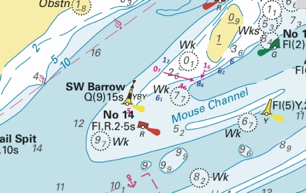
ENGLAND - Insert: depth, 4, and extend 5m contour SE to enclose 51° 32´·43N., 1° 01´·61E. Notice 638 refers Base image courtesy of Imray ID10 Chart IN5043 and Meridian Chartware.
|
Affects: UKHO SNC: 1607 and 1609 UKHO SCC: 5606.6 Imray Full Charts: C1 Imray Leisure Folios: 2100.1 One reduction of depth in the Mouse Channel east of the SW Barrow cardinal buoy. Unlikely to hinder leisure craft. The Image also includes the detail of NtM 335 regarding the new ‘obstn’ west of the ‘Alice’ Danger mark.
|
|
Week 06 |
ENGLAND - Insert: the accompanying block, centred on: 51° 06´·9N., 1° 18´·9E. Notice 554 refers The block is copyright of UKHO
|
Affects: UKHO SNC: 1698 UKHO SCC: 5605.14 Imray Full Charts: C8D Imray Leisure Folios: 2100.11C A UKHO block is for the SNC and relevant SCC chart covering part of the western side of Dover harbour.
|
|
Week 06 |
ENGLAND - The yellow light- The yellow light- Mariners are advised to navigate with caution in the area. Notice 598(T) refers Base image courtesy of Imray ID10 Chart IN5013 and Meridian Chartware.
|
Affects: UKHO SNC: 1698 UKHO SCC: 5605.14 Imray Full Charts: C8D Imray Leisure Folios: 2100.11C Two temporary omission at Dover Harbour; first the lit yellow special buoy ‘North East’ is off station, the second the lit yellow special buoy just outside the eastern entrance is unlit.
|
|
Week 04 |
ENGLAND - Insert:
Notice 335 refers Base image courtesy of Imray ID10 Chart IN5043 and Meridian Chartware.
|
Affects: UKHO SNC: 1607 and 1609 UKHO SCC: 5606.6 and 5606.2 Imray Full Charts: C1 Imray Leisure Folios: 2100.1 A new ‘obstn’ in the Mouse Channel east of the SW Barrow west cardinal buoy and west of the ‘Alice’ danger buoy. Adjacent to the new ‘obstn’ are three unlit Orange buoys; all these close to an existing lit yellow special buoy.
|


-1.jpg)
 Unexploded Ordnances (2024)
  at 51° 28´·67N., 0° 44´·15E.
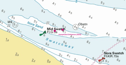
 PA Rep (2024)
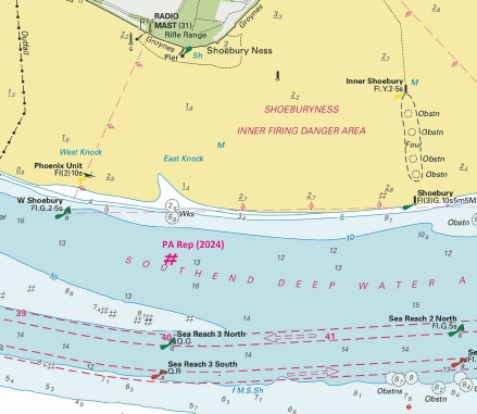
%2024.jpg)
 No 2
No 2  at 51° 25´·753N., 0° 43´·409E.
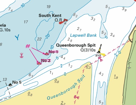

 at 51° 24´·09N., 1° 21´·95E.
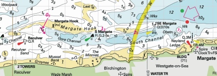
 at 51° 28´·02N., 0° 46´·74E.
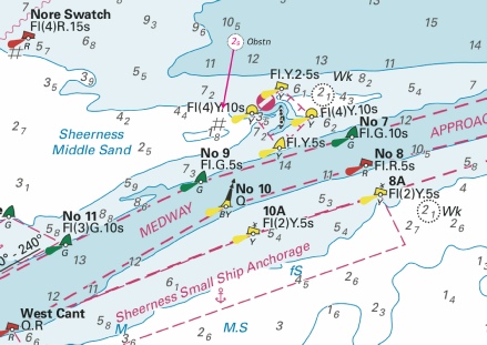
%2024.jpg)
%2024.jpg)
%2024.jpg)

 at 51° 22´·53N., 1° 03´·91E. Delete former
  close SE of above.
 joining:
 , joining:
%2024.jpg)
%2024.jpg)
%2024.jpg)
%2024.jpg)


.jpg)


 at 51° 23´·622N., 0° 30´·265E. and


.jpg)

.jpg)
 at 51° 31´·92N., 1° 02´·86E.
 (3 buoys)