|
Notices - |
||
|
Week 16 |
NETHERLANDS - Insert:
Notice 1702 refers Base image is from Imray chart C2120.7 by courtesy of Imray and Meridian Chartware.
|
Affects: UKHO SNC: 110 (Panel B, Slijkgat to Stellendam) and 110. Imray Full Charts: C30 Imray Leisure Charts: C2120.7 New wreck in the buoyed Slijkgat channel but at the depth, unlikely to hinder leisure craft.
|
|
Week 14 |
NORTH SEA - Within the Slijkgat fairway, the water depth is reduced. Shoaling has been reported between buoy SG- Depth Location 3·7m Mid fairway 2·7m In line with the red buoyage A shoal depth, 2·7m, has been reported in line with the green buoyage at buoy SG- Mariners are advised to keep mid fairway between these positions and navigate with caution in the area. Notice 1516(T) refers Base image is from Imray chart C2120.7 by courtesy of Imray and Meridian Chartware.
|
Affects: UKHO SNC: 110. Imray Full Charts: C30 Imray Leisure Folios: C2120.7 A temporary notice reporting reductions of depth in the Slijkgat – the channel to Stellendam, Holland. Depths are reported down to 2.7m in the marked channel and vessels should follow the mid fairway between the buoys.
|
|
Week 10 |
Reproductions of Belgian Government Charts published 6th March 2025 Chart BE11 North Sea, Vlaamse Banken from Gravelines to Oostkapelle. 50°59´·95 N. - Chart BE101 (INT 1474) International Chart Series, North Sea, Belgium and Netherlands from Oostende to Westkapelle. 51°12´·95 N. - A Brugge. 51°13´·30 N. - B Zeebrugge Achterhaven. 51°17´·58 N. - C Zeebrugge Voorhaven. 51°19´·55 N. - D Blankenberge. 51°18´·52 N. - Chart BE102 (INT 1480) International Chart Series, North Sea, France and Belgium from Dunkerque to Oostende. 51°02´·95 N. - A Nieuwpoort. 51°08´·00 N. - B Oostende. 51°13´·37 N. - UK SN Charts to be withdrawn on 6th March, 2025 SN Chart 1872 North Sea, Dunkerque to Vlissingen. SN Chart 1873 (INT 1480) International Chart Series, North Sea, Dunkerque to Oostende. SN Chart 1874 (INT 1474) International Chart Series, North Sea, Westerschelde Oostende to Westkapelle. |
Announcing several new charts from Belgium is because the UKHO versions will cease on 6th March. Previously Belgium issued chart new editions and the UKHO would then adopt them as ADMIRALTY charts a few months later. Now the UKHO will publish the Belgian Charts in their own series as BE charts, but both the UKHO version and Belgium’s will be the same and updated at the same time. NMs for the four new BE Charts (BE 11, BE101, BE102 and BE 106) will be issued through UKHO NM bulletin as normal and available from the website. Chart 1872 is to be deleted from Notices 3183(T)/23, 3999(T)/24, 286(T)/25, 771(T)/25 and 866(T)/25. Chart 1873 is to be deleted from Notices 3183(T)/23, 286(T)/25, 771(T)/25 and 1123(T)/25. On withdrawal of this chart former Notice 5099(T)/24 is cancelled. Chart 1874 is to be deleted from Notices 3183(T)/23, 3999(T)/24, 771(T)/25 and 1123(T)/25. |
|
Week 10 |
NETHERLANDS - A north cardinal pillar light- Mariners are advised to navigate with caution in the area. Notice 1165(T) refers Base image is from Imray chart C2120.6 by courtesy of Imray and Meridian Chartware.
|
Affects: UKHO SNC: 110, 116 and 1630. Imray Full Charts: C30 Imray Leisure Folios: 2120.6 A new temporary North Cardinal buoy established on the Netherlands coast between Westkapelle and Roompot. The north cardinal is south of the buoyed channel to Roompot.
|
|
Week 6 |
BELGIUM - Insert: limit of restricted area, entry prohibited, pecked line, joining: 51° 15´·03N., 2° 55´·35E. 51° 14´·84N., 2° 55´·58E. 51° 14´·69N., 2° 55´·27E. 51° 14´·88N., 2° 55´·04E. Notice 623 refers Base image is from Imray chart C2120.4 by courtesy of Imray and Meridian Chartware.
|
Affects: UKHO SNC: 1873 and 1874. Imray Full Charts: C30 Imray Leisure Charts: 2021.4. A new restricted area just to the north of the entrance to Oostende (i.e. to the east). Perhaps worth noting if approaching the harbour from the east lest ‘cutting the corner’ and infringe the rules.
|
|
SCROLL DOWN FOR 2024 NOTICES |
||
|
Week 20 |
NORTH SEA - Insert: limit of restricted area, entry prohibited, , pecked line, joining: (a) 51° 31´·59N., 2° 28´·55E. (b) 51° 32´·53N., 2° 29´·69E. (c) 51° 31´·82N., 2° 31´·21E. (d) 51° 30´·87N., 2° 30´·06E. symbol, Notice 2123 refers Base image courtesy of Imray ID10 Chart C30 and Meridian Chartware
. |
Affects: UKHO SNC: 1630 Imray Full Charts: C30 Last week, NtM 2008 announced a family of four cardinal buoys (one each) marking the site of the ‘soon to come’ Princess Elisabeth Island west of the Westhinder bank. This notice announces the area marked by the buoys are now ‘entry prohibited. New image.
|
|
Week 20 |
NETHERLANDS - Replace:
Notice 2134 refers Base image courtesy of Imray ID10 Chart C2120.7 and Meridian Chartware.
|
Affects: UKHO SNC: 110 (Panel B, Slijkgat to Stellendam) Imray Full Charts: C30 Imray Leisure Folios 2120.7 Light characteristics are added to two previous unlit buoys in the heavily marked channel from Slijkgat to Stellendam.
|
|
Week 14 |
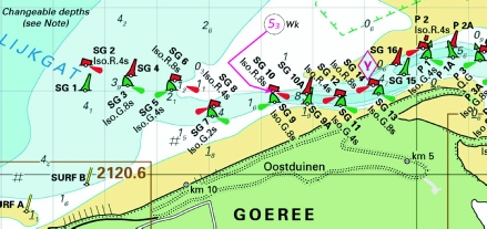
NETHERLANDS - Insert:
Move:
Notice 1512 refers Base image courtesy of Imray ID10 Chart C2120.7 and Meridian Chartware.
|
Affects: UKHO SNC: 110 (Panel B, Slijkgat to Stellendam).. Imray Full Charts: C30 Imray Leisure Folios 2120.7 This, a quite involved notice providing details of new buoys and moved buoys at the entrance of the Slijkgat which leads to Stellendam. The changes have added two pairs of lateral buoys. The annotations on the image is quite involved but the message is that there is a very clearly marked channel with 18 paired lateral buoys.
|
|
Week 13 |
NORTH SEA - Insert: legend, Historic Wk (see Note), at wreck 51° 22´·88N., 2° 27´·13E. Notice 1390 refers Base image courtesy of Imray ID10 Chart C30 and Meridian Chartware
|
Affects: UKHO SNC: 1630 and 2449. UKHO SCC: 5606.2 and 5607.2 Imray Full Charts: C30 Imray Leisure Folios 2110.2 New legend recording an historic wreck close east of the Westhinder south cardinal buoy. The wrecks adjacent were added vide NtM 766/2024.
|
|
Week 02 |
NETHERLANDS - Insert:
Notice 149 refers Base image courtesy of Imray ID10 Chart C30 and Meridian Chartware.
|
Affects: UKHO SNC: 110, 1406, 1630, 1872, 1874 and 2449 Imray Full Charts: C30 Imray Leisure Folios: 2120.6 One new wreck off the Dutch coast, on the Rabsank, north of the Westpit two-
|
 at 51° 51´·00N., 3° 57´·24E.

.jpg)
-1.jpg)
-1.jpg)

 entry prohibited, within:
 SG 16
SG 16 
 SG 15
SG 15 

 Iso.R.4s SG 6 at 51
 Iso.G.8s SG 5A

 at 51° 35´·54N., 3° 07´·96E.