|
Notices - |
||
|
Week 10 |
New Editions of ADMIRALTY Charts to be published on 20th March, 2025 SN Chart 1607 International Chart Series, England - SN Chart 1975 England - SN Chart 2052 International Chart Series, England - SN Chart 2692 England - |
Charts 1607 and 1975 are important charts for us as these are followd by the echart makers. |
|
Week 4 |
ENGLAND - Chart 1975 Insert the accompanying block, centred on: 51° 44´·2N., 1° 02´·2E. Chart 3741 Insert the accompanying block, centred on: 51° 43´·9N., 1° 02´·4E. Chart 5607.3 Insert the accompanying block, centred on: 51° 43´·9N., 1° 02´·4E. Chart 5607.9 Insert the accompanying block, centred on: 51° 44´·1N., 1° 02´·3E. Notice 307 refers The block are copyright of the UKHO.
|
Affects: UKHO SNC: 1975 and 3741. UKHO SCC: 5607.3 and 5607.9. Imray Full Charts: Y17 and C1 Imray Leisure Charts: 2000.1 and 2000.7 Following our survey in September of the Knoll (south side of the River Blackwater estuary), the UKHO is issuing a block for the two relevant SNC and two SCC charts. Whilst the broad outline of the Knoll remains as before, the drying area has significantly moved and enlarged. The Knoll thus provides an obstacle direct from the Spitway to the Nass. The NW Knoll PHB remains correct as positioned. Four separate blocks for each chart.
|
|
SCROLL DOWN FOR 2024 NOTICES |
||
|
Week 49 |
ENGLAND - Insert: depth, 2.4 at 51° 46´·27N., 1° 09´·48E. Delete depth, 3.2, close S.
depth, 0, enclosed by 0m low water line at 51° 45´·84N., 1° 21´·30E. Delete depth 1.5, close W. depth, 1.3 at 51° 47´·78N., 1° 23´·73E. Delete depth, 1.9, close S. depth, 3.3 at 51° 48´·55N., 1° 24´·87E. Delete depth, 4.5, close SW. depth, 5.2 at 51° 50´·34N., 1° 19´·63E. Delete depth, 5.8, close NW. depth, 0.7 at 51° 50´·87N., 1° 16´·96E. Delete depth, 1.3, close NE. Replace:
Notice 5480 refers The base image courtesy of Imray Chart C1 and Meridian Chartware.
|
Affects: UKHO SNC: 1183, 1975 and 2052. UKHO SCC: 5607.3, 5607.4and 5607.2. Imray Full Charts: C1 Imray Leisure Folios 2000.1 Four revised reduced depths over wrecks, six reduced depths and on new wreck and one new obstruction in the Wallet and on the Gunfleet Sands. There is a general trend of reduced depths on the NE tail of the Gunfleet Sands, indeed earlier this year a UK block was issued vide NtM 3694/24 in week 32. The block is slightly amended by this notice. There have been several notices of other reductions of depths so the image incorporates all the changes reported. Two images.
|
|
Week 43 |
New Editions of ADMIRALTY Small Craft Charts to be published on 7th November, 2024 SCC 5607.8 Rivers Ore and Alde. 1:25,000 SCC 5607.13 Continuation of River Crouch. 1:25,000 B Burnham- C Entrance to Walton Backwaters. 1:25,000 D Continuation to Battlesbridge. 1:25,000 SCC 5607.14 A Walton Backwaters. 1:12,500 B Continuation of Landermere Creek. 1:12,500 |
Includes full updates for New Edition and Notices to Mariners affecting source charts. |
|
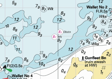
Week 39 |
ENGLAND - Recent survey information has shown that depths less than charted exist within Gunfleet Sands. The most significant are as follows: Depth Position 1·3m 51° 45´·59N., 1° 20´·72E. 2·5m 51° 45´·65N., 1° 21´·01E. 11·3m 51° 45´·73N., 1° 21´·63E. 13·1m 51° 46´·38N., 1° 23´·28E. Recent survey information has shown that depths less than charted exist within Sunk Sand. The most significant are as follows: Depth Position 1·5m 51° 45´·27N., 1° 28´·29E. 3·8m 51° 45´·56N., 1° 28´·60E. 7·7m 51° 41´·23N., 1° 22´·36E. Recent survey information has shown that depths less than charted exist within Kings Channel. The most significant is 13·8m in position 51° 42´·87N., 1° 22´·20E. Mariners are advised to navigate with caution in the area. Charts will be updated when surveying activities are complete. Notice 4414(P) refers The base image courtesy of Imray ID10 Chart C1 and Meridian Chartware.
|
Affects: UKHO SNC: 1183, 1975, and 2692. UKHO SCC: 5607.2 and 5607.4. Imray Full Charts: C1 Imray Leisure Folios 2100.1 and 2000.1 This is a preliminary notice following the recent Civil Hydrology survey reporting reduced depths around the Gunfleet Sands, Sunk Sand and in the Kings Channel. These comprise 1. 4 reductions of depth, 3 adjacent to the Gunfleet Spit cardinal buoy and a fourth with ample water for use north of the cardinal buoy: 2. 2 reductions at the Sunk Head and a third close to the Middle Sunk: 3. A single reduction in the Kings Channel (or West Swin) with ample water for us. There had been a Notice earlier this year (NtM 1026) which advised four reduced depths on the Little Sunk following our survey so those are included in the image. UKHO plan to issue a new edition of SN chart 1975 early next year incorporating all the changes that have been reported this year. That SNC is the leading chart for electronic chartmakers to follow.
|
|
Week 37 |
ENGLAND - Insert: drying height, 0.9, and extend 0m low water line N to enclose 51° 38´·10N., 1° 16´·97E. drying height, 0.8, and extend 0m low water line NW to enclose 51° 38´·01N., 1° 16´·63E. depth, 0.7, and extend 2m contour N to enclose 51° 38´·22N., 1° 17´·68E. Delete depth, 1.9, close S. Notice 4147 refers The base image courtesy of Imray ID10 Chart C1 and Meridian Chartware.
|
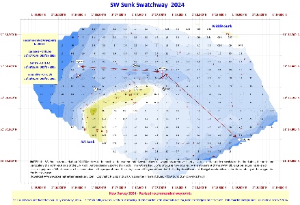
Affects: UKHO SNC: 1183 and 1975. UKHO SCC: 5606.6, 5606.2 and 5607.2. Imray Full Charts: C1 Imray Leisure Folios 2000.1 and 2100.1 Two drying heights and one reduced depth at the SW Sunk swatchway. This notice is acting our survey earlier this year and the drying height show that the swatch has continued to move to the NE year on year. UKHO plan to issue a new edition of Chart 1975 either this year or earlier next. In the meantime I suggest you adopt our chartlet which already available at https://www.crossingthethamesestuary.com/page29.html
|
|
Week 37 |
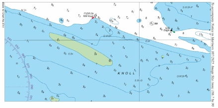
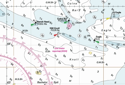
ENGLAND - Insert: legend, Less Water Reported (2024), centred on: 51° 43´·79N., 1° 02´·20E. Notice 4208 refers The base image courtesy of Imray ID10 Chart Y17 and Meridian Chartware.
|
Affects: UKHO SNC: 1975 and 3741. UKHO SCC: 5607.9 and 5607.3. Imray Full Charts: Y17, C1 Imray Leisure Folios 2000.7 This notice provides a warning of ‘Less water reported 2024’ at the Knoll. This was caused by us when we were down there on a rough day – hence no precise depths but our view was that south of the NW Knoll PHB had almost no water at chart datum. On Saturday we conducted a very full survey in ideal conditions but regretfully (and frustratingly) we (I) suffered a major computer crash just after the survey where we lost the majority of the data. We are endeavouring to reinstate the data but it is unlikely. However, it was clear to us that a large area of sand is barely awash so stay clear. The Knoll swatchway does still exist.
|
|
Week 36 |
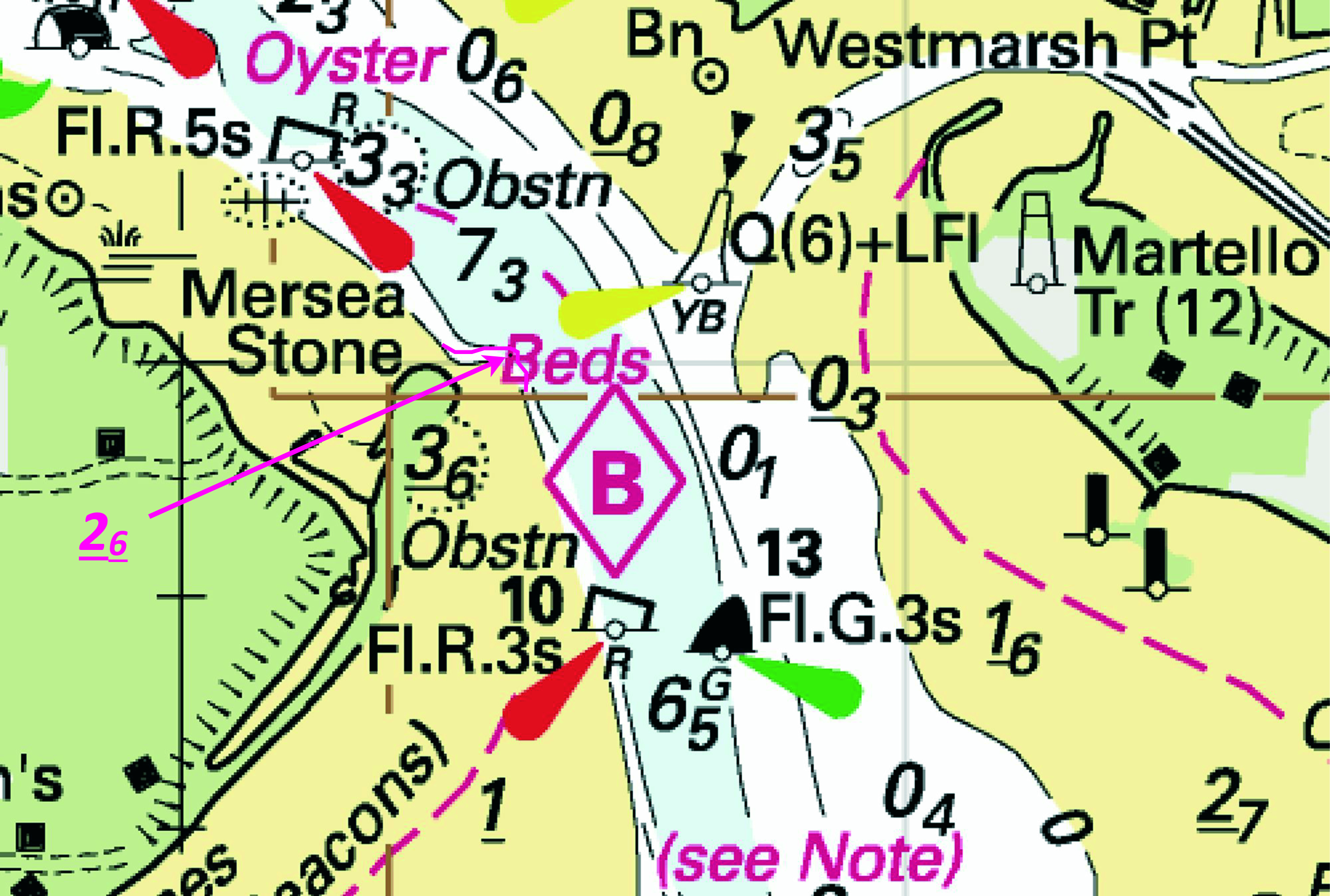
ENGLAND - Insert: drying height, 2.6, and extend 0m low water line NE to enclose 51° 48´·003N., 1° 00´·453E. Delete drying height, 1.4, close S. Notice 4078 refers The base image courtesy of Imray ID10 Chart Y17 and Meridian Chartware.
|
Affects: UKHO SNC: 3741 (Panel A, Brightlingsea) and 3741. UKHO SCC: 5607.10 (Panel C, Brightlingsea), 5607.10 (Panel A, River Colne) and 5607.9. Imray Full Charts: Y17 Imray Leisure Folios 2000.7 One new drying height at Mersea Stone (opposite the entrance to Brightlingsea Creek). The drying height has increased over one metre and will of course be very steep edged. The tide round there does run quite hard.
|
|
Week 34 |
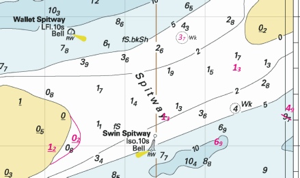
ENGLAND - Insert: drying height, 1.2 at 51° 41´·97N., 1° 07´·10E. Delete drying height, 0.5, close S. drying height, 0.2, and extend 0m low water line E to enclose 51° 42´·05N., 1° 07´·40E. depth, 1.3 at 51° 42´·22N., 1° 08´·49E. Delete depth, 1.5, close NE. depth, 6.9, and extend 10m contour SW to enclose 51° 42´·02N., 1° 09´·17E. Delete depth, 6, close NW. depth, 1.3 at 51° 42´·60N., 1° 09´·40E. Delete depth, 1.8, close N, depth, 1.5, close S and depth, 1.4, close SW (depending on chart). depth, 4.9, and extend 5m contour SE to enclose 51° 42´·28N., 1° 10´·07E. Delete depth, 9.7, close SW. Notice 3917 refers The base image courtesy of Imray ID10 Chart Y17 and Meridian Chartware.
|
Affects: UKHO SNC: 1183 and 1975. UKHO SCC: 5607.3 and 5607.2. Imray Full Charts: C1 and Y17 Imray Leisure Folios 2000.1 This notice provides 6 changes of drying heights and depths at the Spitway as a result of our survey. As we reported, the east edge of the Buxey Sand has extended a little and a little loss of depth in the line twixt the two safe water buoys; the controlled depth there is 1.1m CD close to the Swin Spitway buoy. The image includes the ‘new’ wreck reported by the Civil Hydrology Programme vide NtM 3316/24. I have the issue of the location of the two safe water buoys with Trinity House. Here you can download the new heights and depths and you can also download our chartlet at: https://www.crossingthethamesestuary.com/page29.html
|
|
Week 30 |
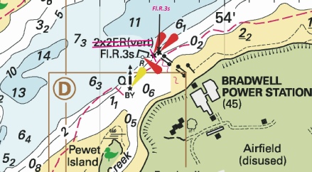
ENGLAND - Amend: light to, Fl.R.3s at 51° 44´·730N., 0° 53´·447E. Delete: legend, 2F.R(vert), centred on: 51° 44´·734N., 0° 53´·537E. Notice 3487 refers Base image courtesy of Imray ID10 Chart Y17 and Meridian Chartware.
|
Affects: UKHO SNC: 3741 (Panel D, Bradwell) and 3741 UKHO SCC: 5607.9 and 5607.11 (Panel A, River Blackwater, Bradwell to Maldon) Imray Full charts: Y17A Imray Leisure Folios 2000.6. Emendation to the lights on the baffle wall off the closed Nuclear Power Station. One red light on the wall and a lit red buoy just upstream of the wall.
|
|
Week 26 |
ENGLAND - Insert:
Notice 2975 refers Base image courtesy of Imray ID10 Chart Y17 and Meridian Chartware.
|
Affects: UKHO SNC: 3750 UKHO SCC: 5607.12 (Panel A, Rivers Crouch and Roach) Imray Full Charts: Y17B Imray Leisure Folios 2000.9 New ‘ship’s’ mooring in the River Crouch, north side near the ship’s turning circle area off Burnham Wick. As it is unlit, probably worth noting. Image.
|
|
Week 23 |
ENGLAND - Insert:
Notice 2559 refers Base image courtesy of Imray ID10 Chart C1 and Meridian Chartware.
|
Affects: UKHO SNC: 1183 and 1975. UKHO SCC: 5607.4 and 5607.2 Imray Full Charts: C1 Imray Leisure Folios 2000.1 Continuation of new issues in the Wallet from Northern Wind extensive survey in the winter of 2023/24. This a wreck with over 8m so unlikely to hinder leisure craft – but might be a popular place for a pot! Midway between Wallets Nos ½ and ¾.
|
|
Week 21 |
ENGLAND - Insert depth, 3 at 51° 45´·81N., 1° 09´·39E. depth, 4.5, and extend 5m contour SE to enclose 51° 45´·93N., 1° 09´·79E. depth, 5.5 at 51° 46´·52N., 1° 12´·13E. Delete depth, 8, close SW. depth, 5.4 at 51° 46´·56N., 1° 11´·64E. depth, 6.3 at 51° 46´·90N., 1° 12´·31E. Delete depth, 7.1, close S. Replace: depth, 7.6, with depth, 6.6 at 51° 45´·92N., 1° 10´·27E. Notice 2230 refers Base image courtesy of Imray ID10 Chart C1 and Meridian Chartware.
|
Affects: UKHO SNC: 1183 and 1975. UKHO SCC: 5607.3, 5607.4 and 5607.2 Imray Full Charts: C1 Imray Leisure Folios 2000.1 Six reductions of depth north of the Wallet off Clacton-
|
|
Week 10 |
ENGLAND - Insert:
Delete:
Notice 1083 refers Base image courtesy of Imray ID10 Chart Y9 and Meridian Chartware.
|
Affects: UKHO SNC: 1975 and 3750. UKHO SCC: 5606.6. Imray Full Charts: Y17B Imray Leisure Folios 2000.8 Note: Former Notice 1319(T)/23 is cancelled. This Notice is catching up with the changes of buoyage at the Ray Sand which occurred in 2023 as a result of surveys. The previous two Safe Water Buoys – the Raysand North and Raysand Middle are removed completely. A new unlit yellow buoy – The Raysand North is placed quite well to the East and the unlit round yellow Ray Sand buoy is moved to match the same longitude meridian. There is a CTTE download at on the Download page which provides the detailed chartlet with has had the correct buoyage since July last year. By all means use the free download. Use the 1° meridian to find the best water north of the Ray Sand between the River Blackwater and the Ray Sand. There are plans for a new edition of UKHO Chart 1975 Thames Estuary – Northern Part in the summer this year which should bring the contours up to date. As of today Navionics have placed the Ray Sand in the right place, have deleted the Raysand Middle, kept the Safe Water coloured Raysand North in the (wrong) old position and the Buxey Beacon in the wrong position. It tends to be handy to know where you are if you use Navionics. C-
|


 at 51° 45´·67N., 1° 10´·95E. and delete
  , close S.
 at 51° 44´·90N., 1° 15´·56E.
 at 51° 45´·51N., 1° 17´·64E.
 at 51° 45´·60N., 1° 18´·33E.
 at 51° 50´·03N., 1° 25´·19E.
 at 51° 53´·91N., 1° 23´·99E.
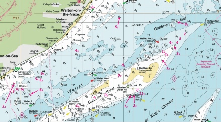
%2024.jpg)
 at 51° 37´·29N., 0° 50´·51E.
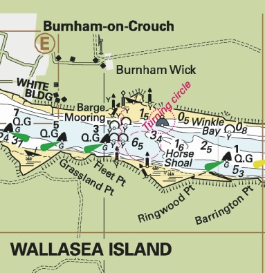


 Raysand North
  Raysand
  Raysand Middle
  Raysand North