|
2025 Permanent/Temporary/Preliminary UKHO Notices to Mariners - |
||
|
Week 23 |
New Editions of ADMIRALTY Charts to be published on 19th June, 2025 SN Chart 2572 - A Queenborough. 1:5,000 B Milton Creek. 1:12,500 C Conyer Creek. 1:12,500 |
|
|
Week 23 |
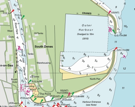
ENGLAND - Insert: depth, 5.9 at 52° 34´·715N., 1° 44´·702E. Delete depth, 7.6, close SW. depth, 7.1 at 52° 34´·583N., 1° 44´·819E. Delete depth, 7.8, close S. depth, 4.9, and extend 5m contour E to enclose 52° 34´·624N., 1° 43´·946E. Delete depth, 4.9, and associated 5m contour, close SE. Replace: depth, 4.4, with depth, 3.8 at 52° 34´·404N., 1° 44´·021E. Notice 2318 refers Base image is from Imray chart C28C by courtesy of Imray and Meridian Chartware.
|
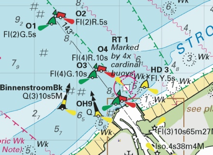
Affects: UKHO SNC: 1534 (INT 1558) (Panel A, Great Yarmouth Outer Harbour), 1534 (INT 1558) (Panel B, Great Yarmouth Haven), 1534 and 1535. UKHO SCC: 5614.4 (Panel B, Great Yarmouth Outer Harbour), 5614.5 (Panel B, Great Yarmouth Haven), 5614.4 (Panel A, Approaches to Great Yarmouth) and 5614.5 (Panel A, Northern Approaches to Great Yarmouth) Imray Full Charts: C28C Four revised depths at Great Yarmouth; one just inside the northern haven entrance, a second outside the southern haven mole, one revised depth in the River yare (which is good for us) and finally a slight reduction off the Spending Beach in the River Yare. Unlikely to hinder leisure craft.
|
|
Week 23 |
ENGLAND - Delete:
Notice 2320 refers Base image is from Imray chart Y9B by courtesy of Imray and Meridian Chartware.
|
Affects: UKHO SNC: 1200 (Panel F, King’s Lynn) UKHO SCC: 5614.10 (Panel C, King’s Lynn) Imray Full Charts: Y9B Deletion of the light marking the Jetty on the west bank in The Great Ouse, opposite the South Quay in King’s Lynn.
|
|
Week 23 |
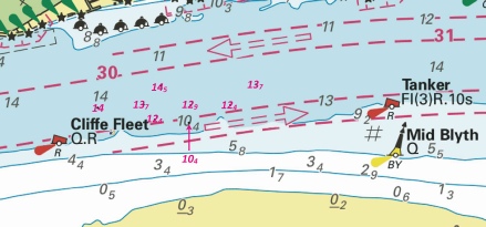
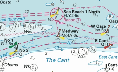
ENGLAND - Insert: depth, 13.7 at 51° 30´·149N., 0° 31´·719E. Delete depth, 13.4, close S depth, 12.4 at 51° 30´·085N., 0° 31´·590E. Delete depth, 12.7, close SW. depth, 12.9 at 51° 30´·085N., 0° 31´·393E. Delete depth, 13.8, close N. depth, 10.4 at 51° 30´·030N., 0° 31´·384E. Delete depth, 11.9, close NW. depth, 12.4 at 51° 30´·040N., 0° 31´·213E. Delete depth, 12.2, close SE. depth, 14.5 at 51° 30´·146N., 0° 31´·240E. depth, 13.7 at 51° 30´·088N., 0° 31´·155E. Delete depth, 14.3, close NW. depth, 14 at 51° 30´·078N., 0° 30´·927E. Delete depth, 14.5, close W. Notice 2347 refers Base image is from Imray chart IN5036 by courtesy of Imray and Meridian Chartware.
|
Affects: UKHO SNC: 1186 (Panel A, Canvey Island to Coalhouse Point). Imray Full Charts: C2 Imray Leisure Folios: 2100.3 Eight reductions of depth in the Yantlet Channel between Cliffe Fleet and Tanker PHBs. Obviously this is monitoring the channel depths for the larger ships as no leisure craft is likely to be hindered.
|
|
Week 23 |
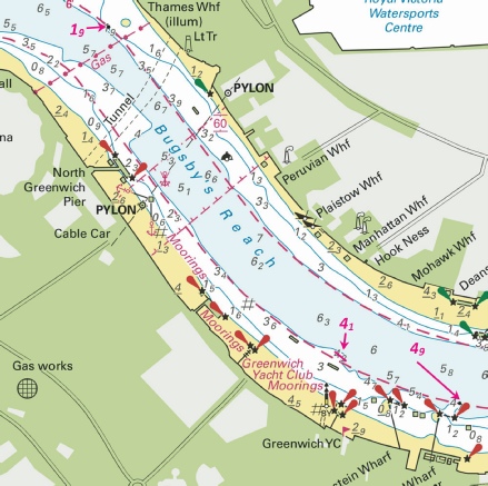
ENGLAND - Insert: depth, 1.9 at 51° 30´·363N., 0° 00´·509E. Delete depth, 0.6, close N. depth, 4.9, and extend 5m contour NE to enclose 51° 29´·745N., 0° 01´·435E. Replace depth, 4.2, with depth, 4.1 at 51° 29´·823N., 0° 01´·121E. Notice 2353 refers Base image is from Imray chart IN5030 by courtesy of Imray and Meridian Chartware.
|
Affects: UKHO SNC: 3337 Imray Full Charts: C2 Imray Leisure Folios: 2100.4 Two increases of depth in Bugsby Reach, River Thames, one by Thames Wharf (opposite of the O2 arena), the other on the edge of the channel SW of Greenwich YC and one very slight reduction of depth off the YC. Unlikely to hinder leisure craft.
|
|
Week 23 |
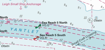
ENGLAND - Insert: depth, 14.5 at 51° 29´·92N., 0° 41´·69E. Delete depth, 15.6, close NE. Notice 2383 refers Base image is from Imray chart IN5037 by courtesy of Imray and Meridian Chartware.
|
Affects: UKHO SNC: 1185 UKHO SCC: 5606.8 Imray Full Charts: C2 Imray Leisure Folios: 2100.2 One reduction of depth in the centre of the Yantlet channel adjacent to Sea Reach No 5 South. Part of monitoring the shipping channel, unlikely to hinder leisure craft.
|
|
Week 23 |
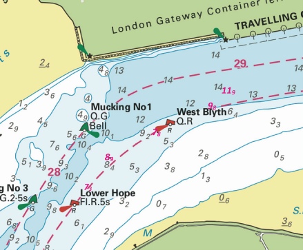
ENGLAND - Replace: depth, 7.5, with depth, 7.3 at 51° 29´·405N., 0° 28´·133E. Notice 2417 refers Base image is from Imray chart IN5036 by courtesy of Imray and Meridian Chartware.
|
Affects: UKHO SNC: 1186 (Panel A, Canvey Island to Coalhouse Point). Imray Full Charts: C2 Imray Leisure Folios: 2100.3 One slight reduction of depth adjacent to the Lower Hope PHB in Lower Hope Reach, River Thames. Unlikely to hinder leisure craft. The image incudes similar reductions reported in the area vide NtM 1016 earlier this year.
|
|
Week 23 |
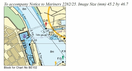
BELGIUM - Insert: the accompanying block, centred on: 51° 14´·0N., 2° 55´·5E. Notice 2282 refers Base image copyright of the UKHO
|
Affects: Belgium SNC: BE102 (Panel B, Oostende) UKHO SCC: 5605.12 (Panel E, Oostende) Imray Full Charts: C30C New UKHO Block for the Belgium SN chart and the UKHO SCC for part of Oostende (e.g. including to Montgomery Docks.
|
|
Week 22 |
ENGLAND - Insert: drying height, 0.2, and extend 0m contour N to enclose 51° 29´·71N., 0° 38´·34E. drying height, 0.3, and extend 0m contour N to enclose 51° 29´·66N., 0° 38´·75E. Delete depth, 0.5, close NW. drying height, 0.6, and extend 0m contour N to enclose 51° 29´·52N., 0° 40´·07E. Delete depth, 0.5, close E Replace: depth, 6.1, with depth, 5.5 at 51° 29´·60N., 0° 40´·68E. Notice 2205 refers Base image is from Imray chart IN5037 by courtesy of Imray and Meridian Chartware.
|
UKHO SNC: 1185 UKHO SCC: 5606.8 Imray Full Charts: C2 Imray Leisure Folios: 2100.2 Three new drying heights on the edge of the Yantlet Flats on the Sea Reach, River Thames, between East Blyth of West Nore Sand. Also one reduced depth close to the West Nore Sand but unlikely to hinder leisure craft. The new drying heights are in line twixt the East Blyth and West Nore Sand buoys as the Yantlet Flats extend gentl to the north.
|
|
Week 21 |
New Editions of ADMIRALTY Charts to be published 22 May 2025 SN Chart 108 - Wells- |
This chart remains affected by Notices 5751(T)/24 (report of the isolated danger buoy south of the North Well SWB) and 489(T)/25. (A yellow wave light- |
|
Week 21 |
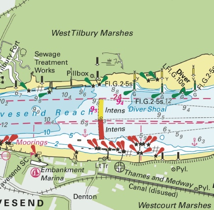
ENGLAND - Insert: depth, 9.3 at 51° 26´·962N., 0° 23´·561E. Delete depth, 9.4, close NW. depth, 9.4 at 51° 27´·022N., 0° 23´·858E. Delete depth, 9.5, close SW. Notice 2140 refers Base image is from Imray chart IN5036 by courtesy of Imray and Meridian Chartware.
|
Affects: UKHO SNC: 1186 (Panel B, Coalhouse Point to Tilbury) Imray Full Charts: C2 Imray Leisure Folios: 2100.3 Two slight reductions of depth in the Gravesend Reach of the River Thames, one amending a depth vide NtM 963 of week 8 of this year. Unlikely to hinder leisure craft.
|
|
Week 21 |
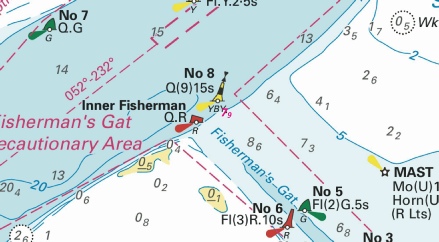
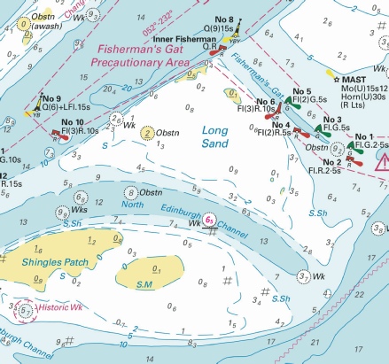
ENGLAND - Insert: depth, 7.9 and extend 8m contour W to enclose 51° 36´·25N., 1° 20´·56E. Delete depth, 8, close E. Notice 2081 refers Base image is from Imray chart IN5043 by courtesy of Imray and Meridian Chartware.
|
Affects: UKHO SNC: 1606, 1607 and 1975. Imray Full Charts: C1 Imray Leisure Charts: 2100.1 and 2000.1. One very slight reduction of depth right in the centre of the northern entrance of Fisherman’s Gat, south of the No 8 west cardinal buoy. Not likely to hinder leisure craft.
|
|
Week 20 |
BELGIUM - Works are in progress within the buoyed entry prohibited area, centred on position 51° 31´·86N., 2° 29´·86E. A pile with light, Mo(U)15s17m10M and Automatic Identification System (AIS), have been established in position 51° 31´·61N., 2° 29´·89E. Mariners are advised to navigate with caution in the area. Notice 2082(T) refers Base image is from Imray chart C30 by courtesy of Imray and Meridian Chartware.
|
Affects: UKHO SNC: 1406, 1630 and 2449. Belgium SNC: BE11 UKHO SCC: 5606.1 and 5607.1 Imray Full Charts: C30 A temporary notice announcing a new pile and light right in the centre of the cluster of cardinal buoys marking the works area for the development of the new Princess Elisabeth Island. This is in Belgium waters east of the Twin special buoy marking the east side of the Noord Hinder TSS. Work creating the new island is now in progress.
|
|
Week 19 |
ENGLAND - Insert:
depth, 8 at 51° 29´·36N., 1° 08´·99E. Delete depth, 8.2, close N. depth, 7.9 at 51° 29´·37N., 1° 08´·73E. Delete depth, 8.2, close W. Notice 1893 refers Base image is from Imray chart IN5043 by courtesy of Imray and Meridian Chartware.
|
Affects: UKHO SNC: 1606, 1607 and 1609. UKHO SCC: 5606.5. Imray Full Charts: C1 Imray Leisure Charts: 2100.1 Two slight reductions of depth and one new obstruction in the Princes Channel between the Princes Mid and No 5. Unlikely to hinder leisure craft.
|
|
Week 19 |
BELGIUM - Insert:
pile, . at: 51° 18´·90N., 3° 06´·45E. 51° 18´·87N., 3° 06´·50E. 51° 18´·84N., 3° 06´·56E. 51° 18´·81N., 3° 06´·61E. 51° 18´·78N., 3° 06´·67E. Move:
Delete:
Notice 1930 refers Base image is from Imray chart C2120.4 by courtesy of Imray and Meridian Chartware.
|
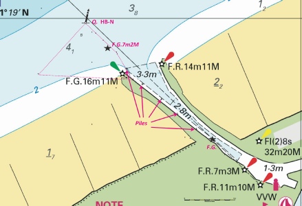
Affects: Belgium SNC: 1BE101 (Panel D, Blankenberge). Imray Full Charts: C30 Imray Leisure Charts: 2120.4 The notice shows some of the progress at the entrance into Blankenberge. In 2024, an area to the north and west of the previous western mole was significantly increased. This notice announces a new starboard (western) light at the entrance of the harbour, five new piles within the western side of the channel and a new FG light just before where the channel widens into the harbour.
|
|
Week 19 |
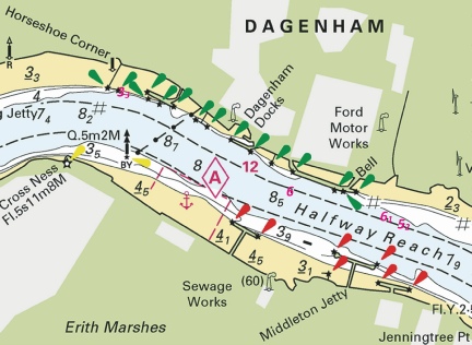
ENGLAND - Insert: depth, 3.3 at 51° 31´·037N., 0° 08´·021E. Delete depth, 3.4, close E. depth, 6 at 51° 30´·689N., 0° 08´·974E. Delete depth, 6.1, close. depth, 6.1 at 51° 30´·595N., 0° 09´·514E. depth, 5.2 at 51° 30´·579N., 0° 09´·605E. Delete depth, 8.5, close SE. Notice 2030 refers Base image is from Imray chart C2 by courtesy of Imray and Meridian Chartware.
|
Affects: UKHO SNC: 2151 (Panel A, Continuation at same scale). Imray Full Charts: C2 Imray Leisure Charts: 2100.4 Four reductions of depth in the River Thames, Halfway Reach. Unlikely to hinder leisure craft.
|
|
Week 18 |
New Editions of ADMIRALTY Charts to be published 15th May, 2025 SN Chart 1504 - |
|
|
Week 18 |
ENGLAND - Insert: depth, 1.5, and extend 2m contour S to enclose 51° 19´·634N., 1° 24´·926E. Delete depth, 2.3, close SE. depth, 1.8, enclosed by 2m contour 51° 19´·614N., 1° 24´·993E. Delete depth, 2.1, close NW. depth, 1.9, and extend 2m contour SW to enclose 51° 19´·602N., 1° 25´·060E. Delete depth, 3.1, close S and depth 2.9 close NW. depth, 1.9, enclosed by 2m contour at 51° 19´·580N., 1° 25´·165E. Delete depth, 2.9, close NE.
Notice 1875 refers Base image is from UKHO SN chart 1827. © Crown Copyright and/or database rights. Reproduced by permission of The Keeper of Public Records and the UK Hydrographic Office (www.GOV.uk/UKHO).
|
Affects: UKHO SNC: 1827 (Panel C, Ramsgate) and 1828 (Panel, Ramsgate). UKHO SCC: 5605.15 (Panel B, Ramsgate). Imray Full Charts: C8F Imray Leisure Charts: 2100.11 Four reductions of depth in the western side of the outer harbour of the Port of Ramsgate, i.e. in the ferry turning area. Also a new wreck identified in the East Gully in the Royal Harbour. Not where we would normally go but probably worth noting.
|
|
Week 18 |
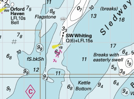
ENGLAND - Insert: depth, 7.4 at 52° 00´·47N., 1° 30´·44E. Delete depth, 8, close N and 7.9 close NW. depth, 7.1 at 52° 00´·73N., 1° 30´·69E. Delete depth, 7.7, close NW. depth, 7.5 at 52° 00´·62N., 1° 30´·57E. Delete depth, 8.1, close NW. Notice 1880 refers Base image is from Imray chart C1 by courtesy of Imray and Meridian Chartware.
|
Affects: UKHO SNC: 1610, 2052 and 2693. UKHO SCC: 5607.5. Imray Full Charts: C1 Imray Leisure Charts: 2000.1 Three slight reductions of depth on the outer end of the SW tail of the Whiting Bank (off the Ore). Unlikely to hinder leisure craft.
|
|
Week 18 |
ENGLAND - Berth extension works are taking place on the Sheerness Docks No. 4 Berth in the vicinity of position 51° 26´·229N., 0° 44´·354E. The works are due for completion by summer 2025. Mariners are advised to navigate with caution in the area and consult Notice to Mariners issued by Peel Ports Medway (https://www.peelports.com/marine/our- Notice 1823(P) refers
|
Affects: UKHO SNC: 3683. UKHO SCC: 5606.2. Imray Full Charts: C1 Imray Leisure Charts: 2100.5 and 2100.6 This is a preliminary notice echoing Local Medway Notice 07 of 2025 about extensive extension works at Berth No 4 at Sheerness Docks. When complete the piling will extend out from the quayside. See the image in the local list. |
|
Week 17 |
13/2025 - Amendment: Moved to new assigned position: Latitude 51˚ 58.456’N., Longitude 001˚ 24.188’E. Movement effected consequent upon a recent survey. No further notice will be given. 14/2025 - Amendment: Moved to new assigned position: Latitude 52˚ 01.840’N., Longitude 001˚ 27.980’E. Movement effected consequent upon a recent survey.
|
Trinity House Notices to Mariners Nos 13 and 14 of 2025 Use the East Coast Pilot chartlets: https://www.eastcoastpilot.com/downloads NOTE: The Deben chartlet has the details and position correct for the Woodbridge Haven Lighted Buoy. However, the Orford Haven Lighted Buoy has been moved approx. 213 degrees 0.25nm since the chartlet was drawn. |
|
Week 17 |
ENGLAND - Replace:
Notice 1764 refers Base image is from Imray chart IN5043 by courtesy of Imray and Meridian Chartware.
|
Affects: UKHO SNC: 1183, 1606 and 1607. UKHO SCC: 5606.2. Imray Full Charts: C1 Imray Leisure Charts: 2100.1 Revised depth in the centre of the North Edinburgh Channel: now swept at 6.5m so unlikely to hinder leisure craft’s progress. But of course the North Edinburgh Channel has no buoyage.
|
|
Week 16 |
ENGLAND - Delete:
51° 26´·756N., 0° 22´·075E. and 51° 26´·753N., 0° 22´·123E. Notice 1661 refers Base image is from Imray chart IN5036 by courtesy of Imray and Meridian Chartware.
|
Affects: UKHO SNC: 1186 (Panel B, Coalhouse Point to Tilbury) and 2151 Imray Full Charts: C2 Imray Leisure Charts: 2100.3 Deletion of two ships moorings on the south side of Gravesend Reach, River Thames off Gravesend.
|
|
Week 16 |
NETHERLANDS - Insert:
Notice 1702 refers Base image is from Imray chart C2120.7 by courtesy of Imray and Meridian Chartware.
|
Affects: UKHO SNC: 110 (Panel B, Slijkgat to Stellendam) and 110. Imray Full Charts: C30 Imray Leisure Charts: C2120.7 New wreck in the buoyed Slijkgat channel but at the depth, unlikely to hinder leisure craft.
|
|
Week 15 |
New Editions of ADMIRALTY Small Craft Charts to be published 24 April 2025 SCC 5606.7 Havengore Bridge to Southend- SCC 5606.8 Southend- SCC 5606.9 Medway Approach Channel. 1:25,000 15 SCC 5606.10 A Mouth of River Medway and West Swale. 1:25,000 B Ferry Reach. 1:12,500 C Ramsgate. 1:5,000 |
This chart remains affected by Notices 4461(P)/23 and 5855(T)/24. This chart remains affected by Notices 4461(P)/23, 515(T)/24, 5715(T)/24 and 5855(T)/24. This chart remains affected by Notices 4461(P)/23 and 5855(T)/24. This chart remains affected by Notices 4461(P)/23 and 4799(T)/24. |
|
Week 15 |
BELGIUM - Insert:
Notice 1587 refers Base image is from Imray chart C30 by courtesy of Imray and Meridian Chartware.
|
Affects: UKHO SNC: 1406 and 2449 UKHO SCC: 5606.1 and 5607.1 Imray Full Charts: C30 In week 36 of last year, Notice 4041 announced a ring of cardinal buoys and yellow special buoys placed to marked the intended Princess Elisabeth Island west of the Westhinder bank and east of the NE heading TSS. This is for the new energy hub to be built in the future. This notice simply names one of the yellow special buoys!
|
|
Week 15 |
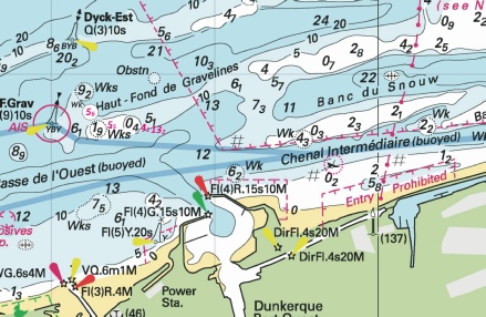
FRANCE - Insert:
depth, 13.2 at 51° 03´·93N., 2° 08´·29E. depth, 4.1, enclosed by 5m contour 51° 04´·00N., 2° 07´·84E. depth, 5.5 at 51° 03´·97N., 2° 06´·82E. Delete depth, 6.3, close N.
Notice 1609 refers Base image is from Imray chart C30 by courtesy of Imray and Meridian Chartware.
|
Affects: UKHO SNC: BE11 and BE102 Imray Full Charts: C30 This notice is for the two Belgium charts which replace two UKHO SN charts. There is a new wreck which shows hull or superstructure at chart datum on the edge of the Chenal Intermediare between the west and east harbours of Dunkerque. Also a new wreck and three reductions of depths on and around the sands north of the Passe de l’Ouest between Gravesline and Dunkerque west.
|
|
Week 14 |
NORTH SEA - Within the Slijkgat fairway, the water depth is reduced. Shoaling has been reported between buoy SG- Depth Location 3·7m Mid fairway 2·7m In line with the red buoyage A shoal depth, 2·7m, has been reported in line with the green buoyage at buoy SG- Mariners are advised to keep mid fairway between these positions and navigate with caution in the area. Notice 1516(T) refers Base image is from Imray chart C2120.7 by courtesy of Imray and Meridian Chartware.
|
Affects: UKHO SNC: 110. Imray Full Charts: C30 Imray Leisure Folios: C2120.7 A temporary notice reporting reductions of depth in the Slijkgat – the channel to Stellendam, Holland. Depths are reported down to 2.7m in the marked channel and vessels should follow the mid fairway between the buoys.
|
|
Week 13 |
ENGLAND - Submarine cable laying works are taking place between North Foreland and Oostende, along a line joining the following positions: 51° 22´·73N., 1° 26´·80E. 51° 23´·45N., 1° 29´·81E. 51° 23´·15N., 1° 32´·74E. 51° 23´·55N., 1° 33´·52E. 51° 23´·55N., 1° 36´·37E. 51° 23´·75N., 1° 38´·91E. 51° 22´·61N., 1° 43´·78E. 51° 22´·72N., 1° 45´·28E. 51° 22´·45N., 1° 48´·39E. 51° 22´·53N., 2° 03´·45E. 51° 22´·63N., 2° 06´·71E. 51° 22´·36N., 2° 08´·59E. 51° 22´·53N., 2° 12´·70E. 51° 21´·80N., 2° 14´·73E. 51° 21´·37N., 2° 17´·93E. 51° 21´·59N., 2° 22´·00E. 51° 22´·47N., 2° 27´·09E. 51° 22´·27N., 2° 28´·42E. 51° 22´·23N., 2° 32´·09E. 51° 21´·27N., 2° 33´·95E. 51° 20´·89N., 2° 40´·56E. 51° 21´·28N., 2° 41´·97E. 51° 21´·00N., 2° 44´·40E. 51° 17´·38N., 2° 47´·99E. 51° 13´·57N., 2° 53´·85E. Charts will be updated when works are complete. This change will be included in a New Edition of Chart 1607. Mariners are advised to navigate with caution in the area. Notice 1339(P) refers Base image is from Imray chart C30 by courtesy of Imray and Meridian Chartware.
|
Affects: UKHO SNC: 323, 1183, 1406, 1610, 1630, 1828 and 2449. Belgium SNC: BE11 and BE102 UKHO SCC: 5605.1, 5605.11, 5606.1, 5606.2, 5606.4 and 5607.1. Imray Full Charts: C30 A submarine cable between North Foreland and the Oostende is to be laid pretty much west to east until off Oostende. No doubt there will be VHF broadcasts when working.
|
|
Week 13 |
ENGLAND - Submarine cable laying works are taking place between East Anglia Three Offshore Wind Farm and a site NE of Felixstowe, along a line joining the following positions: 52° 00´·02N., 1° 25´·40E. 51° 59´·62N., 1° 26´·45E. 52° 00´·39N., 1° 31´·01E. 52° 04´·18N., 1° 37´·24E. 52° 05´·33N., 1° 43´·47E. 52° 07´·88N., 1° 49´·56E. 52° 13´·38N., 2° 18´·29E. 52° 13´·70N., 2° 26´·10E. 52° 17´·77N., 2° 26´·96E. 52° 20´·82N., 2° 30´·40E. 52° 20´·88N., 2° 34´·48E. 52° 27´·14N., 2° 35´·84E. 52° 27´·62N., 2° 44´·99E. 52° 38´·93N., 2° 45´·08E. 52° 40´·24N., 2° 51´·74E. Charts will be updated when works are complete. Mariners are advised to navigate with caution in the area. Notice 1353(P) refers Base image is from UKHO SN chart 1408. © Crown Copyright and/or database rights. Reproduced by permission of The Keeper of Public Records and the UK Hydrographic Office (www.GOV.uk/UKHO).
|
Affects: UKHO SNC: 1406, 1408, 1504, 1543, 1610, 1630, 1631, 2052, 2182A and 2693. UKHO SCC: 5607.5, 5614.1 and 5614.25. Imray Full Charts: C30 Imray Leisure Folios: 2110.2 This preliminary notice advertises the route for the power cable out from just NE of the Deben to the East Anglia Three Offshore Wind Farm. This is associated with the following preliminary notice of the marking of the Wind Farm perimeter. The Image illustrates the route and the location and general marking of the Wind Farm. The following notice shows the detail and characteristics of WF marking.
|
|
Week 13 |
ENGLAND - *Construction of the East Anglia Three Offshore Wind Farm is taking place in the vicinity of position 52° 40´·24N., 2° 51´·74E. The main Wind Farm Array work area is marked by light- Buoy Type Characteristic Position West Cardinal Q(9)15s 52° 31´·81N., 2° 45´·15E. Special Mark Fl.Y.5s 52° 34´·64N., 2° 44´·90E. West Cardinal VQ(9)10s 52° 37´·47N., 2° 44´·87E. Special Mark Fl.Y.5s 52° 40´·30N., 2° 44´·85E. West Cardinal Q(9)15s 52° 43´·12N., 2° 45´·09E. Special Mark Fl.Y.5s 52° 44´·64N., 2° 47´·48E. North Cardinal Q 52° 45´·50N., 2° 50´·96E. Special Mark Fl.Y.5s 52° 45´·71N., 2° 55´·56E. North Cardinal VQ 52° 45´·92N., 3° 00´·15E. East Cardinal Q(3)10s 52° 43´·69N., 3° 00´·75E. Special Mark Fl.Y.5s 52° 40´·79N., 2° 59´·02E. East Cardinal VQ(3)5s 52° 38´·17N., 2° 56´·53E. Special Mark Fl.Y.5s 52° 35´·54N., 2° 54´·04E. East Cardinal Q(3)10s 52° 32´·92N., 2° 51´·56E. South Cardinal VQ(6)+LFl.10s 52° 31´·15N., 2° 48´·25E. All vessels should navigate with caution in the area. A safety zone of 500 metres becomes operational around the turbines under construction. *Former Notice 4802(P)/24 is cancelled. *Indicates new or revised entry Notice 1354(P) refers Base image is from Imray chart C2110.2 by courtesy of Imray and Meridian Chartware.
|
Affects: UKHO SNC: 1504 *These changes will be included in a New Edition of Chart 1504 to be published mid 2025. *Charts 1408, 1631, 2182A and 5614_25 will be updated by Notice to Mariners. This preliminary notice repeats Notice 4802(P) of 2024 which announces the new buoyage marking out the construction area for the East Anglia Three Offshore Wind Farm which will commence later this year. The area is outside of the area which I monitor but I have provided images showing ‘context’ and the buoy ‘map’. While under construction 500m safety zones (aka exclusion zones) will be placed around turbines sites. The power lines are intended to come ashore about 1.4nm north of the Deben at Bawdsey. Subsequent notices will report when the buoys have been placed.
|
|
Week 12 |
FRANCE - Delete:
Notice 1237 refers Base image is from Imray chart C2110.2 by courtesy of Imray and Meridian Chartware.
|
Affects: UKHO SNC: 1351. Imray Full Charts: C30 Imray Leisure Folios: 2110.2 One of several wrecks (exposed at HW) on the beaches just east of Calais harbour is now deleted!
|
|
Week 12 |
ENGLAND - Insert:
51° 29´·01N., 0° 49´·20E. 51° 28´·72N., 0° 44´·63E. 51° 28´·71N., 0° 44´·40E. 51° 30´·11N., 1° 02´·41E. 51° 28´·71N., 0° 56´·60E. 51° 28´·72N., 0° 56´·41E. 51° 28´·80N., 0° 55´·11E.
Notice 1295 refers Base images are from Imray chart IN5037 and 5043 by courtesy of Imray and Meridian Chartware.
|
Affects: UKHO SNC: 1185, 1609 and 3683. Note: Former Notice 2704(T)/24 is cancelled. This update is included in New Edition 1607, published early 2024. UKHO SCC: 5606.7, 5606.9 and 5606.5 Imray Full Charts: C1 Imray Leisure Folios: 2100.2 Last year, following survey work for a new cable laying, unexploded ordnance was discovered – almost a single line of ordnance -
|
|
Week 11 |
No new Notices this week for the monitored area |
|
|
Week 10 |
Reproductions of Belgian Government Charts published 6th March 2025 Chart BE11 North Sea, Vlaamse Banken from Gravelines to Oostkapelle. 50°59´·95 N. - Chart BE101 (INT 1474) International Chart Series, North Sea, Belgium and Netherlands from Oostende to Westkapelle. 51°12´·95 N. - A Brugge. 51°13´·30 N. - B Zeebrugge Achterhaven. 51°17´·58 N. - C Zeebrugge Voorhaven. 51°19´·55 N. - D Blankenberge. 51°18´·52 N. - Chart BE102 (INT 1480) International Chart Series, North Sea, France and Belgium from Dunkerque to Oostende. 51°02´·95 N. - A Nieuwpoort. 51°08´·00 N. - B Oostende. 51°13´·37 N. - UK SN Charts to be withdrawn on 6th March, 2025 SN Chart 1872 North Sea, Dunkerque to Vlissingen. SN Chart 1873 (INT 1480) International Chart Series, North Sea, Dunkerque to Oostende. SN Chart 1874 (INT 1474) International Chart Series, North Sea, Westerschelde Oostende to Westkapelle. New Editions of ADMIRALTY Charts to be published on 20th March, 2025 SN Chart 1607 International Chart Series, England - SN Chart 1975 England - SN Chart 2052 International Chart Series, England - SN Chart 2692 England - |
Announcing several new charts from Belgium is because the UKHO versions will cease on 6th March. Previously Belgium issued chart new editions and the UKHO would then adopt them as ADMIRALTY charts a few months later. Now the UKHO will publish the Belgian Charts in their own series as BE charts, but both the UKHO version and Belgium’s will be the same and updated at the same time. NMs for the four new BE Charts (BE 11, BE101, BE102 and BE 106) will be issued through UKHO NM bulletin as normal and available from the website. Chart 1872 is to be deleted from Notices 3183(T)/23, 3999(T)/24, 286(T)/25, 771(T)/25 and 866(T)/25. Chart 1873 is to be deleted from Notices 3183(T)/23, 286(T)/25, 771(T)/25 and 1123(T)/25. On withdrawal of this chart former Notice 5099(T)/24 is cancelled. Chart 1874 is to be deleted from Notices 3183(T)/23, 3999(T)/24, 771(T)/25 and 1123(T)/25. Charts 1607 and 1975 are important charts for us as these are followed by the echart makers. |
|
Week 10 |
NETHERLANDS - A north cardinal pillar light- Mariners are advised to navigate with caution in the area. Notice 1165(T) refers Base image is from Imray chart C2120.6 by courtesy of Imray and Meridian Chartware.
|
Affects: UKHO SNC: 110, 116 and 1630. Imray Full Charts: C30 Imray Leisure Folios: 2120.6 A new temporary North Cardinal buoy established on the Netherlands coast between Westkapelle and Roompot. The north cardinal is south of the buoyed channel to Roompot.
|
|
Week 9 |
ENGLAND - Insert: depth, 8.9 at 51° 29´·561N., 0° 28´·307E. Delete depth, 9, close NE. depth, 7.8 at 51° 29´·691N., 0° 28´·695E. Delete depth, 7.9, close NE. depth, 9.8 at 51° 29´·809N., 0° 29´·136E. depth, 11.9 at 51° 29´·899N., 0° 29´·828E. Delete depth, 12, close SW. Notice 1016 refers Base image is from Imray chart IN5036 by courtesy of Imray and Meridian Chartware.
|
Affects: UKHO SNC: 1186 (Panel A, Canvey Island to Coalhouse Point). Imray Full Charts: C2 Imray Leisure Folios: 2100.3 Four slight reductions of depth in Hope Reach/Sea Reach of the River Thames between the Lower Hope of Cliffe Fleet buoys. Unlikely to hinder leisure craft.
|
|
Week 9 |
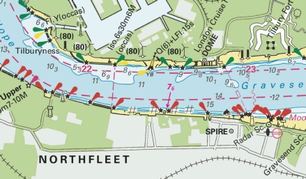
ENGLAND - Replace: depth, 8.4, with depth, 7.6 at 51° 26´·781N., 0° 21´·457E. Notice 1025 refers Base image is from Imray chart IN5036 by courtesy of Imray and Meridian Chartware.
|
Affects: UKHO SNC: 1186 (Panel B, Coalhouse Point to Tilbury) and 2151. Imray Full Charts: C2 Imray Leisure Folios: 2100.3 One reduction of depth in Gravesend Reach of the River Thames close to or alongside a Northfleet jetty. Unlikely to hinder leisure craft.
|
|
Week 8 |
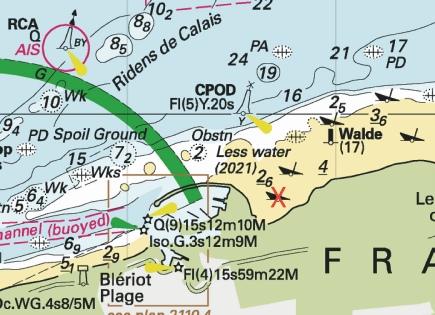
FRANCE - Current meters, mounted on tripod cages, exist in the following positions: Designation Position Wissant 50° 53´·54N., 1° 38´·58E. Gravelines 51° 01´·30N., 2° 05´·60E. Anchoring, dredging and trawling are prohibited within 500m of the meters. Mariners are advised to navigate with caution in the area.
Notice 866(T) refers Base image is from Imray chart IN5007 by courtesy of Imray and Meridian Chartware.
|
Affects: UKHO SNC: 323, 1350, 1872 and 1892. UKHO SCC: 5605.10 and 5605.12 Imray Full Charts: C8 and C30 Two new current meters mounted on tripod cages, one close inshore of Wissant (between Gris-
|
|
Week 8 |
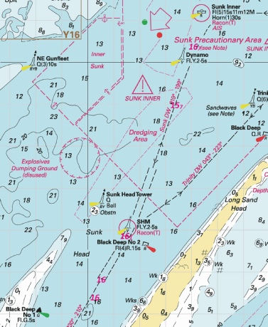
ENGLAND - Insert: depth, 16 at 51° 44´·32N., 1° 30´·29E. Delete depth, 15.8, close SE. depth, 16.7 at 51° 50´·37N., 1° 34´·20E. Delete depth, 17, close S or 16.9 there depth, 16 at 51° 44´·84N., 1° 30´·55E. Delete depth, 15.8, close NE. depth, 15.7 at 51° 49´·02N., 1° 33´·23E. Delete depth, 15.9, close SE. Replace: depth, 15.9, with depth, 16.1 at 51° 45´·87N., 1° 31´·53E. Notice 868 refers Base image is from Imray Chart C1 by courtesy of Imray and Meridian Chartware.
|
Affects: UKHO SNC: 1183, 1975, 2052 and 2692. UKHO SCC: 5607.2 Imray Full Charts: C1 Imray Leisure Folios: 2000.1 Five adjustments of depths on the Black Deep DW channel between the Sunk Inner and the Black Deep No 2. The PLA constantly monitor depths there for the biggest container ships so the depth is never going to hinder use. Note that we need permission from the PLA to be in the Black Deep.
|
|
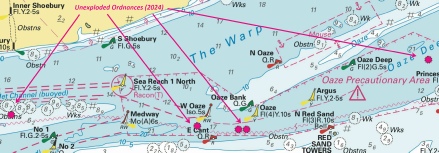
Week 8 |
ENGLAND - Insert: drying height, 0.2, and extend 0m contour S to enclose 51° 31´·33N., 0° 55´·40E. depth, 1.6, and extend 2m contour S to enclose 51° 30´·99N., 0° 53´·93E. Delete depth, 1.2, close W drying height, 0.9, and extend 0m contour S to enclose 51° 58´·78N., 1° 23´·79E. Delete drying height, 0.9, close NW. Notice 907 refers Base images are from Imray Chart IN5043 by courtesy of Imray, Admiralty Chart 2693 and Meridian Chartware.
© Crown Copyright and/or database rights. Reproduced by permission of The Keeper of Public Records and the UK Hydrographic Office (www.GOV.uk/UKHO). |
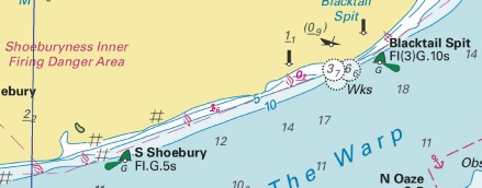
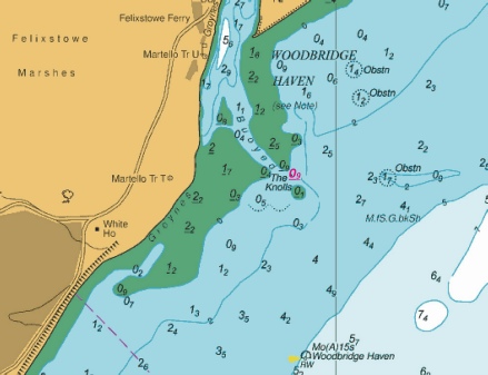
Affects: UKHO SNC: 1607. Note: These updates are included in New Editions 1185, 1609 and 2693 published early 2025. UKHO SCC: 5606.7, 5606.5, 5606.6 and 5706.6 (Panel A, Approaches to Harwich and Woodbridge Haven) Imray Full Charts: C1 and Y16 Imray Leisure Folios: 2100.2 and 2000.3 A bit unusual: three reductions of depth/new drying heights. Two on the edge of Blacktail Spit (off Shoeburyness) between the South Shoebury SHB and the Blacktail Spit SHB and one drying height at the Deben Entrance. I notice the source is from the Environment Agency NOT from Trinity House. I suspect this might not be immediately recent and we should wait for the details from Trinity House which will be announced by East Coast Pilot as soon as they have the new chartlet. Note the image at the Deben will be out of date, it is merely used to show where the drying height is recorded.
|
|
Week 8 |
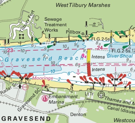
ENGLAND - Insert: depth, 9.4 at 51° 26´·968N., 0° 23´·538E. Delete depth, 9.5, close SE. Notice 963 refers Base image is from Imray chart IN5036 by courtesy of Imray and Meridian Chartware.
|
Affects: UKHO SNC: 1186 (Panel B, Coalhouse Point to Tilbury) Imray Full Charts: C2 Imray Leisure Folios: 2100.3 One very small reduction in the centre of the Gravesend Reach of the River Thames. Unlikely to hinder leisure craft.
|
|
Week 7 |
New Editions of ADMIRALTY Charts to be published on 27th February, 2025 SN Chart 1185 - Continuation of Hole Haven Creek. 1:25,000 SN Chart 1606 - SN Chart 1609 - SN Chart 2693 - A Continuation of River Stour. 1:25,000 B Ipswich. 1:20,000 C Continuation of River Deben. 1:25,000 SN Chart 3683 - Sheerness. 1:6,250 |
|
|
Week 7 |
705(P)/2025 ENGLAND - Source: mv Northern Wind and Trinity House (SEP: 2025000034905 - 1. Recent survey information has shown that depths less than charted exist within the vicinity of Lowestoft and Approaches. The most significant are as follows: Depth Position 6·5m 52° 32´·32N., 1° 49´·03E. 9·4m 52° 30´·22N., 1° 49´·76E. 9·4m 52° 32´·95N., 1° 48´·69E. 9·4m 52° 32´·29N., 1° 49´·15E. 9·4m 52° 33´·63N., 1° 47´·73E. 4·4m 52° 28´·332N., 1° 45´·729E. 1·4m 52° 28´·270N., 1° 45´·681E. 1·2m 52° 27´·86N., 1° 45´·17E. 0·7m 52° 27´·74N., 1° 45´·03E. 1·4m 52° 27´·12N., 1° 44´·80E. 0·8m 52° 26´·59N., 1° 44´·79E. 4·4m 52° 26´·77N., 1° 46´·61E. 1·4m 52° 25´·34N., 1° 44´·98E. 5·0m 52° 38´·01N., 1° 49´·52E. 10m 52° 38´·61N., 1° 49´·45E. 10m 52° 37´·38N., 1° 49´·42E. 30m 52° 37´·79N., 1° 49´·64E. 8·3m 52° 42´·03N., 1° 45´·80E. 13·9m 52° 41´·49N., 1° 46´·77E. 3·6m 52° 40´·73N., 1° 44´·52E. 0·8m 52° 40´·31N., 1° 44´·60E. 4·2m 52° 41´·30N., 1° 44´·88E. 1·5m 52° 37´·78N., 1° 48´·99E. 18·7m 52° 39´·03N., 1° 49´·32E. 28·9m 52° 39´·58N., 1° 49´·46E. 9·4m 52° 39´·80N., 1° 48´·43E. 14·7m 52° 40´·54N., 1° 48´·25E. 7·0m 52° 42´·33N., 1° 43´·83E. 6·9m 52° 41´·90N., 1° 43´·88E. 4·2m 52° 41´·19N., 1° 44´·55E. 4·8m 52° 38´·01N., 1° 45´·03E. * 3·6m 52° 26´·54N., 1° 47´·24E. Mariners are advised to navigate with caution in the area. Charts will be updated when full details are available. *Former Notice 448(P)/25 is cancelled. * Indicates new or revised entry Notice 705(P) refers Base image is from Imray chart C28 by courtesy of Imray and Meridian Chartware.
|
Affects: UKHO SNC: 106, 1534, 1535 and 1543. UKHO SCC: 5614.1, 5614.2, 5614.3, 5614.4, 5614.5 and 5614.6 Imray Full Charts: C28 This is a Preliminary Notice which is part of a series of seven other Preliminary Notices published in the second part of 2024 and one earlier this year. The series has published 36 reductions of depths from Winterton Ness and Kessingland. This Notice is adding four reductions of depth from Hemsby Hole to just north of Great Yarmouth. As such the new reductions should not hinder leisure craft. The notices in in 2025 is 448(P) and 2024 are: 4389(P), 4628(P), 4900(P), 5001(P), 5018(P), 5069(P) and 5165(P). You can access the images for those in the 2024 list. This notice has one reduction of depth right in the middle between the Newcome Sand PHB and the S. Holm SCB (i.e. the Stanford Channel south entrance). At 3.6m there is significant water for leisure craft but the entrance continues to reduce!
|
|
Week 7 |
BELGIUM - Yellow special purpose light- Buoy Type Position Conical 51° 14´·22N., 2° 48´·62E. Conical 51° 13´·40N., 2° 49´·60E. Can 51° 12´·58N., 2° 50´·35E. Notice 771(T) refers Base image is from Imray chart C2120.3 by courtesy of Imray and Meridian Chartware.
|
Affects: UKHO SNC: 1872, 1873, 1874 and 2449. UKHO SCC: 5605.11 Imray Full Charts: C30 Imray Leisure Folios: 2120.3 A temporary notice announcing three new lit yellow special buoys west of Oostende harbour.
|
|
Week 6 |
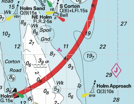
ENGLAND - Insert: depth, 4.6, and extend 5m contour NE to enclose 52° 32´·13N., 1° 48´·69E. Delete depth, 5.2, close SW. depth, 4.9, and extend 5m contour NE to enclose 52° 31´·87N., 1° 48´·99E. Delete depth, 6.1, close NE Notice 609 refers Base image is from Imray chart C28 by courtesy of Imray and Meridian Chartware.
|
Affects: UKHO SNC: 1534, 1535 and 1543. UKHO SCC: 5614.3, 5614.4 (Panel A, Approaches to Great Yarmouth) and 5614.2 Imray Full Charts: C28 Two reductions of depth on the approach to the south entrance of the Holm Channel towards Great Yarmouth. Unlikely to hinder leisure craft. There were quite a few reductions of depth in the approaches to the Holm Channel and in the Corton Road during 2024, viz: NtM 1641, 2943, 3111, 4389(P) and 5473 of 2024 in the Approachs and 2873 and 3008 of 2024 in the Corton Road. You can see those images in the 2024 list on the webpage.
|
|
Week 6 |
BELGIUM - Insert: limit of restricted area, entry prohibited, pecked line, joining: 51° 15´·03N., 2° 55´·35E. 51° 14´·84N., 2° 55´·58E. 51° 14´·69N., 2° 55´·27E. 51° 14´·88N., 2° 55´·04E. Notice 623 refers Base image is from Imray chart C2120.4 by courtesy of Imray and Meridian Chartware.
|
Affects: UKHO SNC: 1873 and 1874. Imray Full Charts: C30 Imray Leisure Charts: 2021.4. A new restricted area just to the north of the entrance to Oostende (i.e. to the east). Perhaps worth noting if approaching the harbour from the east lest ‘cutting the corner’ and infringe the rules.
|
|
Week 5 |
ENGLAND - Insert: depth, 11.1 at 51° 29´·30N., 0° 52´·89E. Delete depth, 12.1, close N. Notice 398 refers Base image is from Imray chart IN5043 by courtesy of Imray and Meridian Chartware.
|
Affects: UKHO SNC: 1607 and 1609. UKHO SCC: 5606.5. Imray Full Charts: C1 Imray Leisure Charts: 2100.1 and 2100.2 One reduction of depth just south of the Sea Reach No 1 yellow special lit buoy. Ample water for leisure craft.
|
|
Week 5 |
ENGLAND - Recent survey information has shown that depths less than charted exist within the vicinity of Lowestoft and Approaches. The most significant are as follows: Depth Position 6·5m 52° 32´·32N., 1° 49´·03E. 9·4m 52° 30´·22N., 1° 49´·76E. 9·4m 52° 32´·95N., 1° 48´·69E. 9·4m 52° 32´·29N., 1° 49´·15E. 9·4m 52° 33´·63N., 1° 47´·73E. 4·4m 52° 28´·332N., 1° 45´·729E. 1·4m 52° 28´·270N., 1° 45´·681E. 1·2m 52° 27´·86N., 1° 45´·17E. 0·7m 52° 27´·74N., 1° 45´·03E. 1·4m 52° 27´·12N., 1° 44´·80E. 0·8m 52° 26´·59N., 1° 44´·79E. 4·4m 52° 26´·77N., 1° 46´·61E. 3·8m 52° 26´·53N., 1° 47´·22E. 1·4m 52° 25´·34N., 1° 44´·98E. 5·0m 52° 38´·01N., 1° 49´·52E. 10m 52° 38´·61N., 1° 49´·45E. 10m 52° 37´·38N., 1° 49´·42E. 30m 52° 37´·79N., 1° 49´·64E. 8·3m 52° 42´·03N., 1° 45´·80E. 13·9m 52° 41´·49N., 1° 46´·77E. 3·6m 52° 40´·73N., 1° 44´·52E. 0·8m 52° 40´·31N., 1° 44´·60E. 4·2m 52° 41´·30N., 1° 44´·88E. 1·5m 52° 37´·78N., 1° 48´·99E. 18·7m 52° 39´·03N., 1° 49´·32E. 28·9m 52° 39´·58N., 1° 49´·46E. 9·4m 52° 39´·80N., 1° 48´·43E. 14·7m 52° 40´·54N., 1° 48´·25E. * 7·0m 52° 42´·33N., 1° 43´·83E. * 6·9m 52° 41´·90N., 1° 43´·88E. * 4·2m 52° 41´·19N., 1° 44´·55E. * 4·8m 52° 38´·01N., 1° 45´·03E. Mariners are advised to navigate with caution in the area. Charts will be updated when full details are available. Former Notice 5165(P)/24 is cancelled. * Indicates new or revised entry Notice 448(P) refers Base image is from Imray chart C28 by courtesy of Imray and Meridian Chartware.
|
Affects: UKHO SNC: 106, 1534, 1535 and 1543. UKHO SCC: 5614.1, 5614.2, 5614.3, 5614.4, 5614.5 and 5614.6 Imray Full Charts: C28 This is a Preliminary Notice which is part of a series of seven other Preliminary Notices published in the second part of 2024. The series has published 33 reductions of depths from Winterton Ness and Kessingland. This Notice is adding four reductions of depth from Hemsby Hole to just north of Great Yarmouth. As such the new reductions should not hinder leisure craft. The notices in 2024 are: 4389(P), 4628(P), 4900(P), 5001(P), 5018(P), 5069(P) and 5165(P). You can access the images for those in the 2024 list.
|
|
Week 5 |
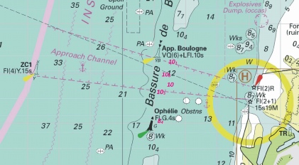
FRANCE - Insert: depth, 10.1 at 50° 45´·25N., 1° 31´·66E. Delete depth, 10.9, close N. depth, 10.8 at 50° 44´·98N., 1° 31´·46E. Delete depth, 12.5, close E depth, 10, enclosed by 10m contour 50° 44´·77N., 1° 31´·51E. depth, 10.5 at 50° 44´·63N., 1° 31´·19E. Delete depth, 16.5, close N. depth, 8.4, enclosed by 10m contour at 50° 44´·06N., 1° 31´·16E. Notice 500 refers Base image is from Imray chart C8 by courtesy of Imray and Meridian Chartware.
|
Affects: UKHO SNC: 1892. Imray Full Charts: C8 Five reductions of depth off Boulogne on the Bassure de Baas between the south cardinal ‘App. Boulogne’ and the starboard hand ‘Ophelie’. Unlikely to be hinder by leisure craft.
|
|
Week 5 |
EAST COAST OF ENGLAND - Latitude 52° 55.482’N., Longitude 001° 18.990’E. Amendment: The nominal range of the main light has been permanently reduced to 18 nautical miles. The light characteristic remains unaltered but with a revised composition of fl 1.0s, ec 4.0s. Trinity House Notice to Mariners 14/2023, dated 27th April 2023, is hereby cancelled. Trinity House Notice to Mariners 2 of 2025 refers
|
Affects: UKHO SNC: 106, 1503 and 1504. Imray Full Charts: C28 Notice from Trinity House reported permanent changes in the light characteristic of the Cromer Lighthouse. No image considered necessary. |
|
Week 4 |
New Editions of ADMIRALTY Charts to be published on 30th January, 2025. SNC 1186 - A Canvey Island to Coalhouse Point. 1:12,500 B Coalhouse Point to Tilbury. 1:12,500 SNC 2151 - A Continuation at same scale. 1:12,500 SNC 3337 England - A Barking Creek. 1:6,250 B Thames Tidal Barrier. 1:5,000 |
|
|
Week 4 |
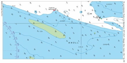
ENGLAND - Chart 1975 Insert the accompanying block, centred on: 51° 44´·2N., 1° 02´·2E. Chart 3741 Insert the accompanying block, centred on: 51° 43´·9N., 1° 02´·4E. Chart 5607.3 Insert the accompanying block, centred on: 51° 43´·9N., 1° 02´·4E. Chart 5607.9 Insert the accompanying block, centred on: 51° 44´·1N., 1° 02´·3E. Notice 307 refers The block are copyright of the UKHO.
|
Affects: UKHO SNC: 1975 and 3741. UKHO SCC: 5607.3 and 5607.9. Imray Full Charts: Y17 and C1 Imray Leisure Charts: 2000.1 and 2000.7 Following our survey in September of the Knoll (south side of the River Blackwater estuary), the UKHO is issuing a block for the two relevant SNC and two SCC charts. Whilst the broad outline of the Knoll remains as before, the drying area has significantly moved and enlarged. The Knoll thus provides an obstacle direct from the Spitway to the Nass. The NW Knoll PHB remains correct as positioned. Four separate blocks for each chart.
|
|
Week 4 |
ENGLAND - Insert: drying height, 0.2, and extend 0m low water line NE to enclose 51° 47´·82N., 1° 37´·14E. Delete depth, 0.7, close NE and depth, 0.5 or 0.4, close SW. depth, 13.2 at 51° 48´·80N., 1° 35´·99E. Delete depth, 13.7, close NW. drying height, 0.2, and extend 0m low water line NE to enclose 51° 47´·71N., 1° 36´·95E. Delete depth, 0.3, close SW. Replace: depth, 13.3, with depth, 12.8 at 51° 48´·91N., 1° 36´·16E. Notice 349 refers Base image is from Imray chart C1 by courtesy of Imray and Meridian Chartware.
|
Affects: UKHO SNC: 1183, 1610, 1975, 2052 and 2692. UKHO SCC: 5607.2. Imray Full Charts: C1 Imray Leisure Charts: 2100.1 and 2000.1 Two new drying heights on the northeast tail of the Long Sand Head and one reduced depths close by the Trinity south cardinal buoy on the Deep Water channel. It should remain prudent not to cut over the end of the tail of the Long Sand Head as it continues slowly to extend to the northeast.
|
|
Week 3 |
FRANCE - The Automatic Identification System, AIS, at the South cardinal light- (WGS84 DATUM) Notice 286(T) refers Base image is from Imray chart C30 by courtesy of Imray and Meridian Chartware.
|
Affects: UKHO SNC: 323, 1406, 1610, 1872, 1873 and 2449. UKHO SCC: 5605.1, 5605.10, 5605.11 and 5606.1. Imray Full Charts: C30 Temporary notice advising that the south cardinal buoy ‘DY2’ in the Dyck Oriental channel (offshore north of Dunkerque) has its AIS temporarily removed.
|
|
Week 2 |
No Notices for this week affecting the monitored areas |
|
|
Week 1 |
No Notices for this week affecting the monitored areas |
|


 Q.G at 52° 45´·163N., 0° 23´·419E.
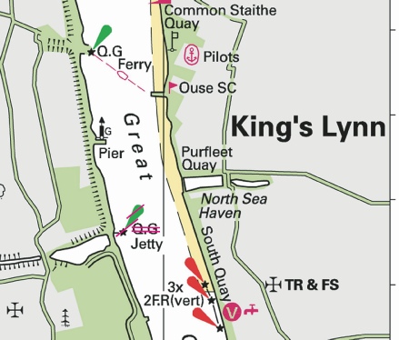


.jpg)
 at 51° 29´·27N., 1° 09´·65E. Delete depth
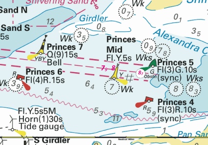
 at 51° 19´·743N., 1° 25´·473E. Delete depth,
 Wk
Wk 
 at:
at: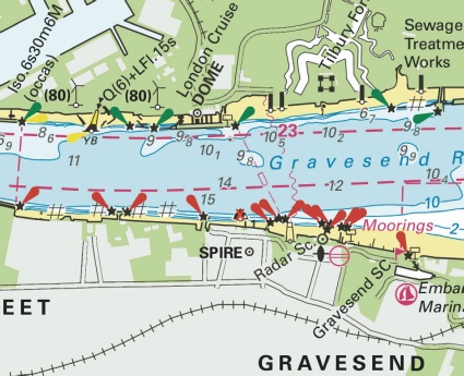
 at 51° 51´·00N., 3° 57´·24E.
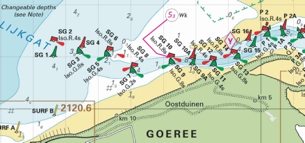
 Fl(5)Y.20s TME1
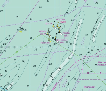
 at 51° 03´·22N., 2° 13´·66E.
.jpg)
-2.jpg)
.jpg)
.jpg)
.jpg)
 Unexploded Ordnances (2024)
  at 51° 28´·67N., 0° 44´·15E.
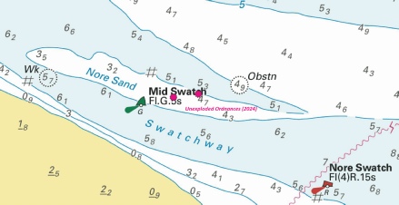
.jpg)

.jpg)
.jpg)
.jpg)
.jpg)
.jpg)

.jpg)