|
Notices - |
||
|
Week 15 |
FRANCE - Insert:
depth, 13.2 at 51° 03´·93N., 2° 08´·29E. depth, 4.1, enclosed by 5m contour 51° 04´·00N., 2° 07´·84E. depth, 5.5 at 51° 03´·97N., 2° 06´·82E. Delete depth, 6.3, close N.
Notice 1609 refers Base image is from Imray chart C30 by courtesy of Imray and Meridian Chartware.
|
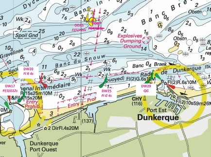
Affects: UKHO SNC: BE11 and BE102 Imray Full Charts: C30 This notice is for the two Belgium charts which replace two UKHO SN charts. There is a new wreck which shows hull or superstructure at chart datum on the edge of the Chenal Intermediare between the west and east harbours of Dunkerque. Also a new wreck and three reductions of depths on and around the sands north of the Passe de l’Ouest between Gravesline and Dunkerque west.
|
|
Week 13 |
ENGLAND - Submarine cable laying works are taking place between North Foreland and Oostende, along a line joining the following positions: 51° 22´·73N., 1° 26´·80E. 51° 23´·45N., 1° 29´·81E. 51° 23´·15N., 1° 32´·74E. 51° 23´·55N., 1° 33´·52E. 51° 23´·55N., 1° 36´·37E. 51° 23´·75N., 1° 38´·91E. 51° 22´·61N., 1° 43´·78E. 51° 22´·72N., 1° 45´·28E. 51° 22´·45N., 1° 48´·39E. 51° 22´·53N., 2° 03´·45E. 51° 22´·63N., 2° 06´·71E. 51° 22´·36N., 2° 08´·59E. 51° 22´·53N., 2° 12´·70E. 51° 21´·80N., 2° 14´·73E. 51° 21´·37N., 2° 17´·93E. 51° 21´·59N., 2° 22´·00E. 51° 22´·47N., 2° 27´·09E. 51° 22´·27N., 2° 28´·42E. 51° 22´·23N., 2° 32´·09E. 51° 21´·27N., 2° 33´·95E. 51° 20´·89N., 2° 40´·56E. 51° 21´·28N., 2° 41´·97E. 51° 21´·00N., 2° 44´·40E. 51° 17´·38N., 2° 47´·99E. 51° 13´·57N., 2° 53´·85E. Charts will be updated when works are complete. This change will be included in a New Edition of Chart 1607. Mariners are advised to navigate with caution in the area. Notice 1339(P) refers Base image is from Imray chart C30 by courtesy of Imray and Meridian Chartware.
|
Affects: UKHO SNC: 323, 1183, 1406, 1610, 1630, 1828 and 2449. Belgium SNC: BE11 and BE102 UKHO SCC: 5605.1, 5605.11, 5606.1, 5606.2, 5606.4 and 5607.1. Imray Full Charts: C30 A submarine cable between North Foreland and the Oostende is to be laid pretty much west to east until off Oostende. No doubt there will be VHF broadcasts when working.
|
|
Week 12 |
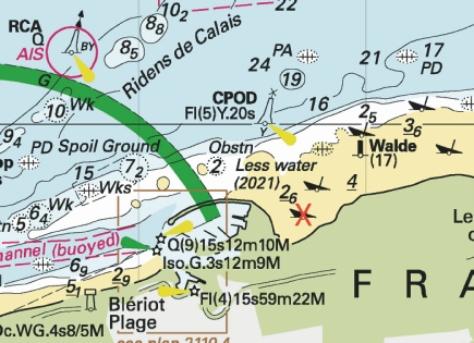
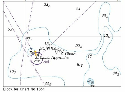
FRANCE - Delete:
Notice 1237 refers Base image is from Imray chart C2110.2 by courtesy of Imray and Meridian Chartware.
|
Affects: UKHO SNC: 1351. Imray Full Charts: C30 Imray Leisure Folios: 2110.2 One of several wrecks (exposed at HW) on the beaches just east of Calais harbour is now deleted!
|
|
Week 8 |
FRANCE - Current meters, mounted on tripod cages, exist in the following positions: Designation Position Wissant 50° 53´·54N., 1° 38´·58E. Gravelines 51° 01´·30N., 2° 05´·60E. Anchoring, dredging and trawling are prohibited within 500m of the meters. Mariners are advised to navigate with caution in the area.
Notice 866(T) refers Base image is from Imray chart IN5007 by courtesy of Imray and Meridian Chartware.
|
Affects: UKHO SNC: 323, 1350, 1872 and 1892. UKHO SCC: 5605.10 and 5605.12 Imray Full Charts: C8 and C30 Two new current meters mounted on tripod cages, one close inshore of Wissant (between Gris-
|
|
Week 5 |
FRANCE - Insert: depth, 10.1 at 50° 45´·25N., 1° 31´·66E. Delete depth, 10.9, close N. depth, 10.8 at 50° 44´·98N., 1° 31´·46E. Delete depth, 12.5, close E depth, 10, enclosed by 10m contour 50° 44´·77N., 1° 31´·51E. depth, 10.5 at 50° 44´·63N., 1° 31´·19E. Delete depth, 16.5, close N. depth, 8.4, enclosed by 10m contour at 50° 44´·06N., 1° 31´·16E. Notice 500 refers Base image is from Imray chart C8 by courtesy of Imray and Meridian Chartware.
|
Affects: UKHO SNC: 1892. Imray Full Charts: C8 Five reductions of depth off Boulogne on the Bassure de Baas between the south cardinal ‘App. Boulogne’ and the starboard hand ‘Ophelie’. Unlikely to be hinder by leisure craft.
|
|
Week 3 |
FRANCE - The Automatic Identification System, AIS, at the South cardinal light- (WGS84 DATUM) Notice 286(T) refers Base image is from Imray chart C30 by courtesy of Imray and Meridian Chartware.
|
Affects: UKHO SNC: 323, 1406, 1610, 1872, 1873 and 2449. UKHO SCC: 5605.1, 5605.10, 5605.11 and 5606.1. Imray Full Charts: C30 Temporary notice advising that the south cardinal buoy ‘DY2’ in the Dyck Oriental channel (offshore north of Dunkerque) has its AIS temporarily removed.
|
|
SCROLL DOWN FOR 2024 NOTICES |
||
|
Week 48 |
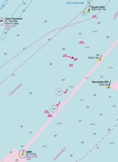
DOVER STRAIT - Insert: depth, 28.5 at 51° 08´·18N., 1° 40´·06E. Delete depth, 29.5, close N. depth, 27 at 51° 08´·55N., 1° 40´·91E. Delete depth, 28.5, close N. depth, 27.5 at 51° 13´·50N., 1° 44´·41E. Delete depth, 28.5, close N. Replace: depth, 28, with depth, 27 at 51° 09´·49N., 1° 41´·36E. depth, 26.5, with depth, 25.5 at 1° 08´·37N., 1° 40´·35E and delete depth, 27.5, close NW. Notice 5368 refers The base image courtesy of Imray Chart IN5007 and Meridian Chartware.
|
Affects: UKHO SNC: 323, 1406, 1610, 1892 and 2449. UKHO SCC: 5605.2, 5605.1 (Panel B, Approaches to Dover Straits) and 5606.1. Note: This update is included in New Edition 5606.3, published late 2024. Imray Full Charts: C8 Imray Leisure Folios 2100.1 Five reductions of depth in the SW going TSS twixt the South Falls south cardinal buoy and the MPC yellow special buoy. Very unlikely to hinder leisure craft at those depths! The image includes three other reduced depths reported in NtM 5161 in week 45.
|
|
Week 46 |
FRANCE - Insert: depth, 15.7, and extend 20m contour NE to enclose 50° 58´·994N., 1° 45´·228E. depth, 8.5, enclosed by 10m contour 50° 58´·893N., 1° 45´·495E. depth, 8.2, enclosed by 10m contour 50° 58´·852N., 1° 45´·485E. Delete: depth, 14.3, and associated 15m contour at 50° 58´·718N., 1° 44´·774E. depth, 15, and associated 15m contour at 50° 58´·926N., 1° 45´·037E. Notice 5233 refers The base image courtesy of Imray Chart IN5007 and Meridian Chartware.
|
Affects: UKHO SNC: 1351 UKHO SCC: 5605.1 Panel B, 5605.2 and 5606.1. Imray Full Charts: C8 Imray Leisure Folios 2100.7 Three reduction of depth close east and south-
|
|
Week 46 |
FRANCE - Insert:
Notice 5244 refers The base image courtesy of Imray Chart IN5007 and Meridian Chartware.
|
Affects: UKHO SNC: 1406, 1610, 1892 2449 and 5500. UKHO SCC: 5605.1 (Panel A, Western Approaches to Dover Strait), 5605.1 (Panel B, Northern approaches to Dover Strait), 5605.2 and 5606.1 Imray Full Charts: C8 Imray Leisure Folios 2100.7 A new Pilot Boarding Place for LPG bulk carriers in the Dunkerque Waiting Area. The location is adjacent to routes we might use between the East Goodwins and Calais.
|
|
Week 26 |
FRANCE - Delete: legend, (2 buoys), centred on: 51° 06´·38N., 2° 16´·24E. or
Notice 2951 refers Base image courtesy of Imray ID10 Chart C30 and Meridian Chartware.
|
Affects: UKHO SNC: 323, 1350 and 1873 UKHO SCC: 5605.10 Imray Full Charts: C30 Last year a Notice (3541/23)announced two new yellow special buoy (POG and ODAS) on the offshore banks off Dunkerque. This notice deletes the two yellow buoys.
|
|
Week 21 |
FRANCE - Chart 1350 Insert: the accompanying block, A, centred on: 51° 00´·4N., 2° 10´·7E. the accompanying block, B, centred on: 51° 02´·7N., 2° 18´·8E. legend, 12m, centred on: 51° 02´·38N., 2° 15´·79E. legend, Quai du Braek, centred on: 51° 02´·19N., 2° 15´·34E. Amend light to, Fl(3)G.12s11m6M 51° 03´·25N., 2° 21´·20E. Chart 1873 Insert: depth, 2.6, and extend 5m contour SE to enclose 51° 06´·07N., 2° 30´·02E. depth, 2, enclosed by 2m and 5m contours at 51° 05´·55N., 2° 29´·22E. Notice 2367 refers Base image courtesy of Imray ID10 Chart C30 and Meridian Chartware.
|
Affects: UKHO SNC: 1350 and 1873. UKHO SCC: 5606.7. Imray Full Charts: C30 and C30A This notice has two blocks for the commercial side of the Dunkerque Port Est and two reductions of depth in the Passe de Zuydcoote – the important channel in shore between Dunkerque and Nieupoort. Worth noting.
|
|
Week 13 |
DOVER STRAIT - Insert: depth, 15.3 at 51° 21´·10N., 2° 17´·78E. Delete depth, 15.7, close NE and depth, 16.9, close SE. depth, 17.6, and extend 20m E to enclose 51° 20´·68N., 2° 18´·74E. depth, 29.5, and extend 30m contour NW to enclose 51° 17´·06N., 2° 14´·15E. Delete depth, 32, close NW. depth, 21.5 at 51° 16´·50N., 2° 14´·80E. Delete depth, 24.5, close E. depth, 26.5 of 51° 16´·32N., 2° 05´·80E. Delete depth, 28.5, close NE and N and depth, 28, close W. depth, 29, and extend 30m contour SE to enclose 51° 15´·89N., 2° 05´·83E. Chart 1351 Insert the accompanying block, centred on: 50° 59´·0N., 1° 45´·3E. Notice 1351 refers Base image courtesy of Imray ID10 Chart C30 and Meridian Chartware. The block is copyright of the UKHO
|
Affects: UKHO SNC: 323, 1351, 1406, 1610, 1872, 1873 and 2449. UKHO SCC: 5605.2, 5605.1 (Panel B, Northern Approaches to Dover Strait), 5606.1 and 5607.1 Imray Full Charts: C8 Imray Leisure Folios 2110.2 Six reduced depths in the West Hinder and Sandiettie TSS and a new UKHO block around the Calais Approche west cardinal buoy. This is deep water so should not hinder leisure craft. 2 reductions just south of the Fairybank S. south cardinal buoy and 4 reductions in the Sandiettie TSS in the junction area with the West Hinder TSS. Ample water also around the Calais west cardinal.
|
|
Week 04 |
FRANCE - Insert: depth, 1.9, enclosed by 2m and 5m contours and extend 10m contour SE to enclose 51° 09´·39N., 2° 23´·95E. depth, 5, enclosed by 5m contour at 51° 08´·60N., 2° 21´·90E. Delete depth, 5.5, close NW.
Notice 302 refers Base image courtesy of Imray ID10 Chart C30 and Meridian Chartware.
|
Affects: UKHO SNC: 1872 and 1874 UKHO SCC: 5605.10 and 5605.11 Imray Full Charts: C30 Two reductions of depth on the southern side of the Binnen Ratel bank whch is one of the off-
|
|
Week 04 |
FRANCE - Insert: depth, 27 at 51° 02´·49N., 1° 36´·13E. Delete depth, 28, close E and depth, 27.5, close SW. depth, 12.6 at 51° 05´·24N., 1° 50´·71E. Delete depth, 13.5, close S. circular limit of low water line, radius 100m, centred on: 50° 54´·97N., 1° 39´·38E. Delete depth, 0.8, close N. depth, 1.7, enclosed by 2m contour at 50° 54´·38N., 1° 38´·24E. Delete depth, 2.7, close N. depth, 1.3, enclosed by 2m contour at 50° 54´·05N., 1° 37´·51E. Delete depth, 2.5, close NW. Replace: depth, 2.8, with depth, 1.4, enclosed by 2m contour at 50° 55´·18N., 1° 39´·58E.
Notice 341 refers Base image courtesy of Imray ID10 Chart IN5036 and Meridian Chartware.
|
Affects: UKHO SNC: 323, 1406, 1892 and 2449 UKHO SCC: 5605.10, 5605.2, 5605.1 (Panel B, Northern Approaches to Dover Strait) and 5606.1 Imray Full Charts: C8 Two reduction of depth in the English Channel, neither of which will hinder leisure craft, four reductions of depth on the Banc a la Ligne and La Barriere off Wissant west of Calais and a change of wreck designation east of the Colbart SW south cardinal buoy Of two reductions in the Channel, one is in the NE running TSS, the other on the tail of the Ruytingen bank. Of the four reductions of depth ‘off Wissant’, two are shown as soundings, the third is a circular limit of low water line. I admit needing to turn to ‘Symbols and Abbreviations’ for the ‘low water line level’ for the exact definition; that being the line of 0. Probably suggests trying to find a lee east of Gris Nez is not the best idea. The wreck east of the Colbart SW just in the TSS separation zone is now defined as an unsurveyed wreck over which the exact depth is unknown but is considered to have a safe clearance of 20m – so unlikely to hinder leisure craft. Note it is marked ‘PA’ i.e. positon approximate. Three images.
|
 Fl(5)Y.20s TME1
  at 51° 03´·22N., 2° 13´·66E.


-1.jpg)
-1.jpg)
-1.jpg)

-1.jpg)
 at 51° 02´·28N., 1° 46´·40E.
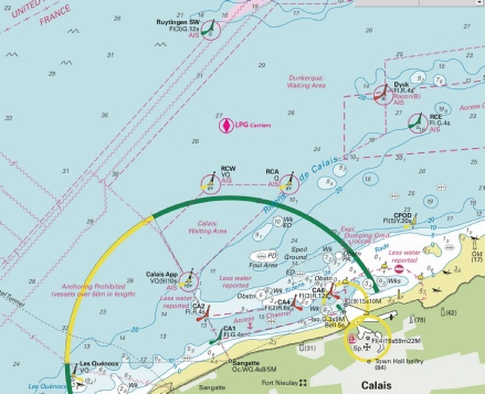


 with
with  at 50° 48´·11N., 1° 19´·95E.

