|
Notices - |
||
|
Week 17 |
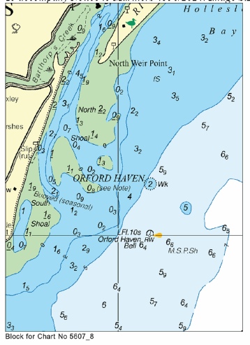
13/2025 - Amendment: Moved to new assigned position: Latitude 51˚ 58.456’N., Longitude 001˚ 24.188’E. Movement effected consequent upon a recent survey. No further notice will be given. 14/2025 - Amendment: Moved to new assigned position: Latitude 52˚ 01.840’N., Longitude 001˚ 27.980’E. Movement effected consequent upon a recent survey.
|
Trinity House Notices to Mariners Nos 13 and 14 of 2025 Use the East Coast Pilot chartlets: https://www.eastcoastpilot.com/downloads NOTE: The Deben chartlet has the details and position correct for the Woodbridge Haven Lighted Buoy. However, the Orford Haven Lighted Buoy has been moved approx. 213 degrees 0.25nm since the chartlet was drawn. |
|
Week 10 |
New Editions of ADMIRALTY Charts to be published on 20th March, 2025 SN Chart 1607 International Chart Series, England - SN Chart 1975 England - SN Chart 2052 International Chart Series, England - SN Chart 2692 England - |
Charts 1607 and 1975 are important charts for us as these are followd by the echart makers. |
|
Week 8 |
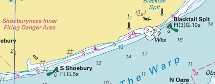
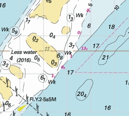
ENGLAND - Insert: drying height, 0.2, and extend 0m contour S to enclose 51° 31´·33N., 0° 55´·40E. depth, 1.6, and extend 2m contour S to enclose 51° 30´·99N., 0° 53´·93E. Delete depth, 1.2, close W drying height, 0.9, and extend 0m contour S to enclose 51° 58´·78N., 1° 23´·79E. Delete drying height, 0.9, close NW. Notice 907 refers Base images are from Imray Chart IN5043 by courtesy of Imray, Admiralty Chart 2693 and Meridian Chartware.
© Crown Copyright and/or database rights. Reproduced by permission of The Keeper of Public Records and the UK Hydrographic Office (www.GOV.uk/UKHO). |
Affects: UKHO SNC: 1607. Note: These updates are included in New Editions 1185, 1609 and 2693 published early 2025. UKHO SCC: 5606.7, 5606.5, 5606.6 and 5706.6 (Panel A, Approaches to Harwich and Woodbridge Haven) Imray Full Charts: C1 and Y16 Imray Leisure Folios: 2100.2 and 2000.3 A bit unusual: three reductions of depth/new drying heights. Two on the edge of Blacktail Spit (off Shoeburyness) between the South Shoebury SHB and the Blacktail Spit SHB and one drying height at the Deben Entrance. I notice the source is from the Environment Agency NOT from Trinity House. I suspect this might not be immediately recent and we should wait for the details from Trinity House which will be announced by East Coast Pilot as soon as they have the new chartlet. Note the image at the Deben will be out of date, it is merely used to show where the drying height is recorded.
|
|
Week 7 |
New Editions of ADMIRALTY Charts to be published on 27th February, 2025 SN Chart 1185 - Continuation of Hole Haven Creek. 1:25,000 SN Chart 1606 - SN Chart 1609 - SN Chart 2693 - A Continuation of River Stour. 1:25,000 B Ipswich. 1:20,000 C Continuation of River Deben. 1:25,000 SN Chart 3683 - Sheerness. 1:6,250 |
|
|
SCROLL DOWN FOR 2024 NOTICES |
||
|
Week 47 |
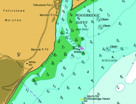
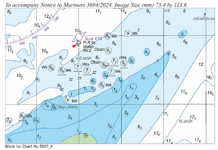
ENGLAND - Chart 2052 Insert the accompanying block, centred on: 51° 58´·6N., 1° 23´·8E. Chart 2693 Insert the accompanying block, centred on: 51° 58´·6N., 1° 23´·3E. Chart 5607.6 (Panel A, Approaches to Harwich and Woodbridge Haven) Insert the accompanying block, centred on: 51° 58´·5N., 1° 23´·4E. Chart 5607.5 Insert the accompanying block, centred on: 51° 58´·6N., 1° 23´·8E. Notice 5305 refers The blocks are copyright of the UKHO.
|
Affects: UKHO SNC: 2052 and 2693. UKHO SCC: 5607.6 (Panel A, Approaches to Harwich and Woodbridge Haven) and 5607.5. Imray Full Charts: Y16. Imray Leisure Folios 2000.3 Four new UKHO blocks for the Woodbridge Haven (Deben Entrance); each four variations of the same area for the two SNC and two SCC chart. UKHO does not display the buoyage beyond the SWB so refer to: https://www.eastcoastpilot.com/downloads for the Imray/East Coast Pilot detailed chartlets. The image is from the UKHO downloads:
|
|
Week 46 |
ENGLAND - Insert:
Notice 5180 refers The base image courtesy of Imray Chart Y16G and Meridian Chartware.
|
Affects: UKHO SNC: 1491 UKHO SCC: 5606.14 (Panel B. Erith Reach to Hook Ness). Imray Full Charts: Y16 and Y16G Imray Leisure Folios 2000.5E New FOUL close in shore north of the entrance into Shotley Marina.
|
|
Week 44 |
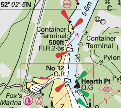
ENGLAND - Insert: drying height, 0.2, and extend 0m contour NE to enclose 52° 02´·280N., 1° 09´·394E. Notice 4989 refers The base image courtesy of Imray Chart Y16 and Meridian Chartware.
|
Affects: UKHO SNC: 2693 (Panel B, Ipswich). UKHO SCC: 5607.7. Imray Full Charts: Y16 Imray Leisure Folios 2000.5B One new drying height close by the PHB called ‘500ft’ by the western side Container Terminal in the River Orwell at Ipswich.
|
|
Week 43 |
New Editions of ADMIRALTY Small Craft Charts to be published on 7th November, 2024 SCC 5607.8 Rivers Ore and Alde. 1:25,000 SCC 5607.13 Continuation of River Crouch. 1:25,000 B Burnham- C Entrance to Walton Backwaters. 1:25,000 D Continuation to Battlesbridge. 1:25,000 SCC 5607.14 A Walton Backwaters. 1:12,500 B Continuation of Landermere Creek. 1:12,500 |
Includes full updates for New Edition and Notices to Mariners affecting source charts. |
|
Week 41 |
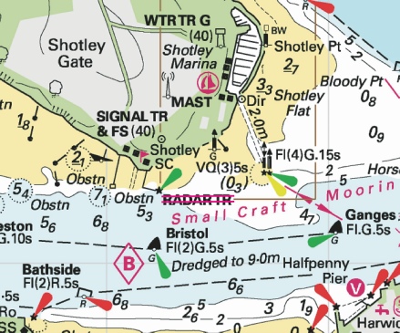
ENGLAND - Delete: legend, RADAR TOWER, at light 51° 57´·211N., 1° 16´·231E. Notice 4648 refers The base image courtesy of Imray ID10 Chart Y16 and Meridian Chartware.
|
Affects: UKHO SNC: 1491 and 2693. UKHO SCC: 5607.6 (Panel A, Approaches to Harwich and Woodbridge Haven) and 5607.7 (Panel A, River Stour). Imray Full Charts: Y16 Imray Leisure Folios 2000.4 and 2000.5 Following changes in Harwich, the legend for the Radar Tower just west of the entrance to Shotley Marina is deleted. Note only the legend is deleted.
|
|
Week 39 |
ENGLAND - Insert: the appropriate accompanying block, centred on: 52° 02´·2N., 1° 27´·9E. Notice 4356 refers The blocks are UKHO copyright.
|
Affects: UKHO SNC: 2052 and 2693. UKHO SCC: 5607.5 and 5607.8 (Panel B, Orford Haven and approaches. Imray Full Charts: C1 Imray Leisure Folios 2100.2 This notice has four similar UKHO blocks for the Orford Haven, two for SN charts and 2 for SC Charts. All results from the Trinity House survey this year.
|
|
Week 38 |
ENGLAND - Insert: the accompanying note, LOCAL NOTICE TO MARINERS, centred on: 51° 55´·087N., 1° 11´·602E. Notice 4303 refers
|
Affects: UKHO SNC: 1594. Imray Full Charts: Y12 Imray Leisure Folios 2000.1 This notice provides a note to chart of the River Stour to the effect that the Harwich Haven Authority issues relevant local notices.
|
|
Week 35 |
New Editions of ADMIRALTY Charts to be published 29 August 2024 SNC 2695 England - A Walton Backwaters. 1:12,500 B Continuation of Landermere Creek. 1:12,500 C Rivers Ore and Alde. 1:25,000 D Southwold Harbour. 1:7,500 |
Includes changes to depths from the latest Harwich Haven Authority and Trinity House surveys. |
|
Week 33 |
ENGLAND - Insert: depth, 9.8, and extend 10m contour E to enclose 51° 57´·94N., 1° 31´·13E. Delete depth, 11.5, close E. Notice 3803 refers The base image courtesy of Imray ID10 Chart C1 and Meridian Chartware.
|
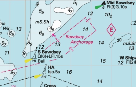
Affects: UKHO SNC: 2693. UKHO SCC: Imray Full Charts: C1 Imray Leisure Folios 2000.1 One reduction of depth on the southern tail of the very end of the Bawdsey Bank. Unlikely to hinder leisure craft.
|
|
Week 32 |
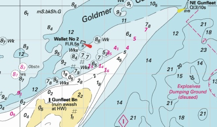
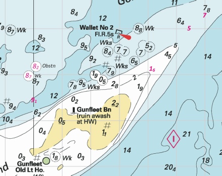
ENGLAND - Insert: depth, 0.9, and extend 2m contour NW to enclose 51° 46´·81N., 1° 19´·67E. Delete depth, 2.7, close SW. depth, 1.3, enclosed by 2m contour at 51° 48´·23N., 1° 23´·33E. depth, 1.4, and extend 2m contour NW to enclose 51° 48´·21N., 1° 23´·86E. depth, 4, and extend 5m contour NE to enclose 51° 48´·74N., 1° 25´·11E. Delete depth, 4.5, close SW and depth, 5.8, close SE. depth, 4.1, enclosed by 5m contour 51° 48´·76N., 1° 24´·60E. depth, 3.5, enclosed by 5m contour at 51° 48´·63N., 1° 24´·23E. Delete depth, 12.5, and associated 10m contour, close SW and depth, 7.3, close E. Chart 1975 Insert the accompanying block, centred on: 51° 48´·4N., 1° 23´·7E. Chart 5607.4 Insert the accompanying block, centred on: 51° 48´·4N., 1° 23´·7E. Notice 3694 refers UKHO Blocks are copyright of the UKHO. The base image courtesy of Imray ID10 Chart C1 and Meridian Chartware.
|
Affects: UKHO SNC: 1183, 1975 and 2052. UKHO SCC: 5607.4 and 5607.2. Imray Full Charts: C2 Imray Leisure Folios 2000.1 Six reductions of depth on the (NE) head of the Gunfleet Sands. The image includes 4 additional reduced depths in the area and one wreck and one obstn by virtue of earliers NtMs Nos 2019, 2559 and 3530. The notice also include new block for the same area for SN chart 1975 and SC chart 5607.4. The blocks illustrate the extended shallow area of the head of the Sands.
|
|
Week 30 |
ENGLAND - Insert: depth, 5, enclosed by 5m contour at 51° 49´·02N., 1° 25´·44E. Delete depth, 6.8, close SE. depth, 1.6, and extend 2m contour NE to enclose 51° 48´·11N., 1° 24´·13E. Delete depth, 3.5, close E. depth, 9.1, and extend 10m contour SE to enclose 51° 47´·43N., 1° 20´·02E. depth, 7 at 51° 49´·30N., 1° 25´·98E. Delete depth, 8.9, close SE. depth, 13.4, and extend 15m contour SE to enclose 51° 42´·67N., 1° 33´·73E. Notice 3530 refers Base image courtesy of Imray ID10 Chart C1 and Meridian Chartware.
|
Affects: UKHO SNC: 1183, 1975 and 2052. UKHO SCC: 5607.2. Imray Full Charts: C1 Imray Leisure Folios 2000.1. A total of 5 reductions of depth on and around the Gunfleet Sands and on the east side of the Long Sand. 3 are on the north tail of the Gunfleet Sands, one in the Wallet (twixt Nos 2 and 4) and one reduction of depth on the east side of the Long Sand. Two images: the Gunfleet and Wallet image includes an obstruction and a wreck vide NtMs 2019 and 2559. The Long Sand image has a ‘host’ of reductions of depth added vide NtMs 1880 and 2796. Later this year or early next year we can expect a new edition of Chart 1975.
|
|
Week 28 |
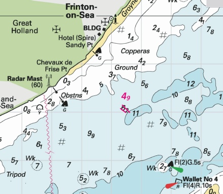
ENGLAND - Insert depth, 4.9, enclosed by 5m contour at 51° 48´·30N., 1° 15´·49E. Delete depth, 6.2, close S and depth, 5.6, close NW. Notice 3240 refers Base image courtesy of Imray ID10 Chart C1 and Meridian Chartware.
|
Affects: UKHO SNC: 1183 and 1975. UKHO SCC: 5607.4, 5607.5 and 5607.6 Imray Full Charts: C1 Imray Leisure Folios 2000.1 One solitary reduction of depth inshore of the Wallet off Frinton-
|
|
Week 28 |
ENGLAND - A seabed current meter has been established in 51° 56´·80N., 1° 22´·60E. The current meter is marked by two special purpose light- Mariners are advised to navigate with caution in the area. Former Notice 2270(T)/24 is cancelled. Notice 3264(T) refers Base image courtesy of Imray ID10 Chart Y16 and Meridian Chartware.
|
Affects: UKHO SNC: 2052 and 2693. UKHO SCC: 5607.2 and 5607.4 Imray Full Charts: C1 and Y16 Imray Leisure Folios 2000.1 and 2000.4 This is confirming a recent Harwich Haven Authority notice establishing a seabed current meter marked by two yellow special buoys. This is located on Felixstowe Ledge off Cobbolds Point.
|
|
Week 24 |
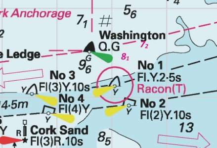
ENGLAND - Insert depth, 7.2 at 51° 56´·45N., 1° 27´·26E. Delete depth, 7.4, close NW and depth, 8.5, close NE. depth, 8.1 at 51° 56´·62N., 1° 27´·61E. Delete depth, 9, close NW. Notice 2657 refers Base image courtesy of Imray ID10 Chart C1 and Meridian Chartware.
|
Affects: UKHO SNC: 2052 and 2693. UKHO SCC: 5607.4 and 5607.5 Imray Full Charts: C1 Imray Leisure Folios 2000.1 Two reductions of depth north of the Harwich Deep Water Channel close by the Washington SHB. Ample water for leisure craft.
|
|
Week 21 |
ENGLAND - Insert depth, 5.2 at 51° 55´·44N., 1° 23´·24E. Delete depth, 5.9, close N. depth, 10.4 at 51° 55´·43N., 1° 28´·61E. Delete depth, 11.5 , close SW. Notice 2269 refers Base image courtesy of Imray ID10 Chart Y16 and Meridian Chartware.
|
Affects: UKHO SNC: 2052 and 2693. UKHO SCC: 5607.6 (Panel A, Approaches to Harwich and Woodbridge Haven), 1506.4 and 5607.5 Imray Full Charts: Y16 Imray Leisure Folios 2000.1 and 2000.4 Two reductions of depth off Harwich, one just on the south edge of the Harwich Secondary South Channel north of Cork Ledge, the other in the South Channel, south-
|
|
Week 21 |
ENGLAND - A seabed current meter has been established in 51° 55´·11N., 1° 30´·67E. The current meter is marked by two special purpose light- Notice 2270(T) refers Base image courtesy of Imray ID10 Chart C1 and Meridian Chartware.
|
Affects: UKHO SNC: 2052 2692 and 2693. UKHO SCC: 5607.5 Imray Full Charts: C1 Imray Leisure Folios 2000.1 and 2000.4 A temporary Notice reporting a new seabed current meter placed to the south-
|
|
Week 19 |
ENGLAND - Insert:
Notice 2019 refers Base image courtesy of Imray ID10 Chart C1 and Meridian Chartware.
|
Affects: UKHO SNC: 1183 and 1975. UKHO SCC: 5607.4 and 5607.2. Imray Full Charts: C1 Imray Leisure Folios 2000.1 This notice is probably the product of the detailed survey that the Northern Wind undertook at the end of last year. Two new obstructions off Clacton and Frinton. Both in plenty of water for us so unlikely to hinder leisure craft – but of course might be a good lobster pot place! Traditionally pots in this area are poorly marked by some!
|
|
Week 19 |
ENGLAND - Insert:
depth, 0.5 at 51° 42´·62N., 1° 30´·92E. Delete depth, 1.7, close SE. depth, 06, enclosed by 2m contour at 51° 42´·52N., 1° 30´·62E. Delete depth, 4, close S. depth, 2.8 at 51° 39´·71N., 1° 37´·81E. Delete depth, 7, close SW and depth, 3.5, close SW. depth, 4.3, and extend 5m contour SE to enclose 51° 38´·82N., 1° 37´·65E. Delete depth, 8.3, close NW. depth, 4.4, and extend 5m contour NE to enclose 51° 38´·32N., 1° 37´·70E. Delete depth, 7.1, close NE. depth, 4.3, and extend 5m contour SE to enclose 51° 40´·63N., 1° 38´·11E. Delete depth, 6.6, close S. depth, 2.9, and extend 5m contour SE to enclose 51° 39´·49N., 1° 37´·73E. Delete depth, 7, close SW. Notice 2107 refers Base image courtesy of Imray ID10 Chart C1 and IN5043 and Meridian Chartware.
|
Affects: UKHO SNC: 1183 and 1975. UKHO SCC: 5607.4 and 5607.2. Imray Full Charts: C1 Imray Leisure Folios 2000.1 Two new wrecks on the Gunfleet Sands between the east side of the wind farm and the Old Gunfleet Lighthouse. Probably unwise to try to cross the sands at that point. The Notice also has seven reductions of depth, two very shallow depths on the Long Sand, east side of the London Array wind farm and five reductions of depth along the east side of the Kentish Knock. Probably unwise to cross the Long Sand just east of the wind farm. Three images: of the second image at the Long Sand three other reductions of depth reported by the earlier Notice 1880 has been included.
|
|
Week 11 |
New Editions of ADMIRALTY Charts on 28th March, 2024 Standard National Charts Chart 2692 England - Small Craft Charts SCC 5605.8 Dover to Deal. 1:37,500 SCC 5605.9 Deal to Ramsgate. 1:37,500 SCC 5607.4 Southern Approaches to Harwich. 1:50,000 SCC 5607.5 Harwich to Orford Ness. 1:50,000 SCC 5607.6 A Approaches to Harwich and Woodbridge Haven. 1:25,000 B Continuation of River Deben. 1:25,000 SCC 5607.7 Rivers Stour and Orwell. A River Stour. 1:25,000 B River Orwell. 1:25,000 C Ipswich. 1:10,000 SCC 5607.8 A Rivers Ore and Alde. 1:25,000 B Orford Haven and Approaches. 1:25,000 |
Includes changes to depths from the latest British Government and Port of London Authority surveys. Includes full updates for New Edition and Notices to Mariners affecting source charts. |
|
Week 08 |
ENGLAND - Insert: depth, 4.9 , enclosed by 5m contour at 51° 57´·110N., 1° 15´·077E. Replace: depth, 5.3 , with depth, 4 , enclosed by 5m contour at 51° 56´·948N., 1° 17´·011E. Notice 815 refers Base image courtesy of Imray ID10 Chart Y16 and Meridian Chartware.
|
Affects: UKHO SNC: 1491 and 2693 UKHO SCC: 5607.7 Imray Full Charts: Y16 Imray Leisure Folios: 2000.5 Two reductions of depth in the River Stour, one west of the Parkeston starboard hand buoy, the other off the Trinity House Pier. At 4m+ unlikely to hinder leisure craft.
|
|
Week 04 |
ENGLAND - Amend: legend to, 5·0m, centred on: 52° 03´·024N., 1° 09´·776E. legend to, 3·9m, centred on: 52° 02´·888N., 1° 09´·783E. and 52° 02´·944N., 1° 09´·785E. legend to, 6·6m, centred on: 52° 02´·461N., 1° 09´·450E. legend to, 6·5m, centred on: 52° 02´·335N., 1° 09´·441E. Notice 320 refers Base image courtesy of Imray ID10 Chart Y16A and Meridian Chartware.
|
Affects: UKHO SNC: 1183, 1606 and 1607 UKHO SCC: 5607.7 (Panel C, Ipswich) Imray Full Charts: Y16A Imray Leisure Folios: 2000.5 (Panel A, Ipswick) Five new legends displaying dredged depths in the Ipswich Marina and Docks. All ample water for us of course.
|


 at 51° 57´·545N., 1° 16´·725E.
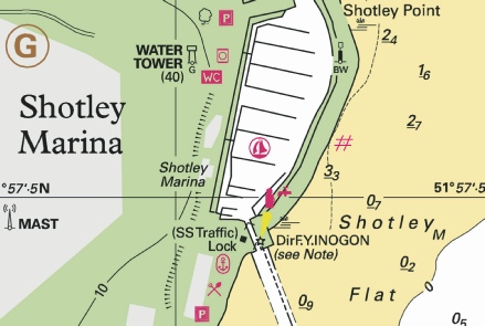
%2024.jpg)

.jpg)
 Obstn
Obstn 


