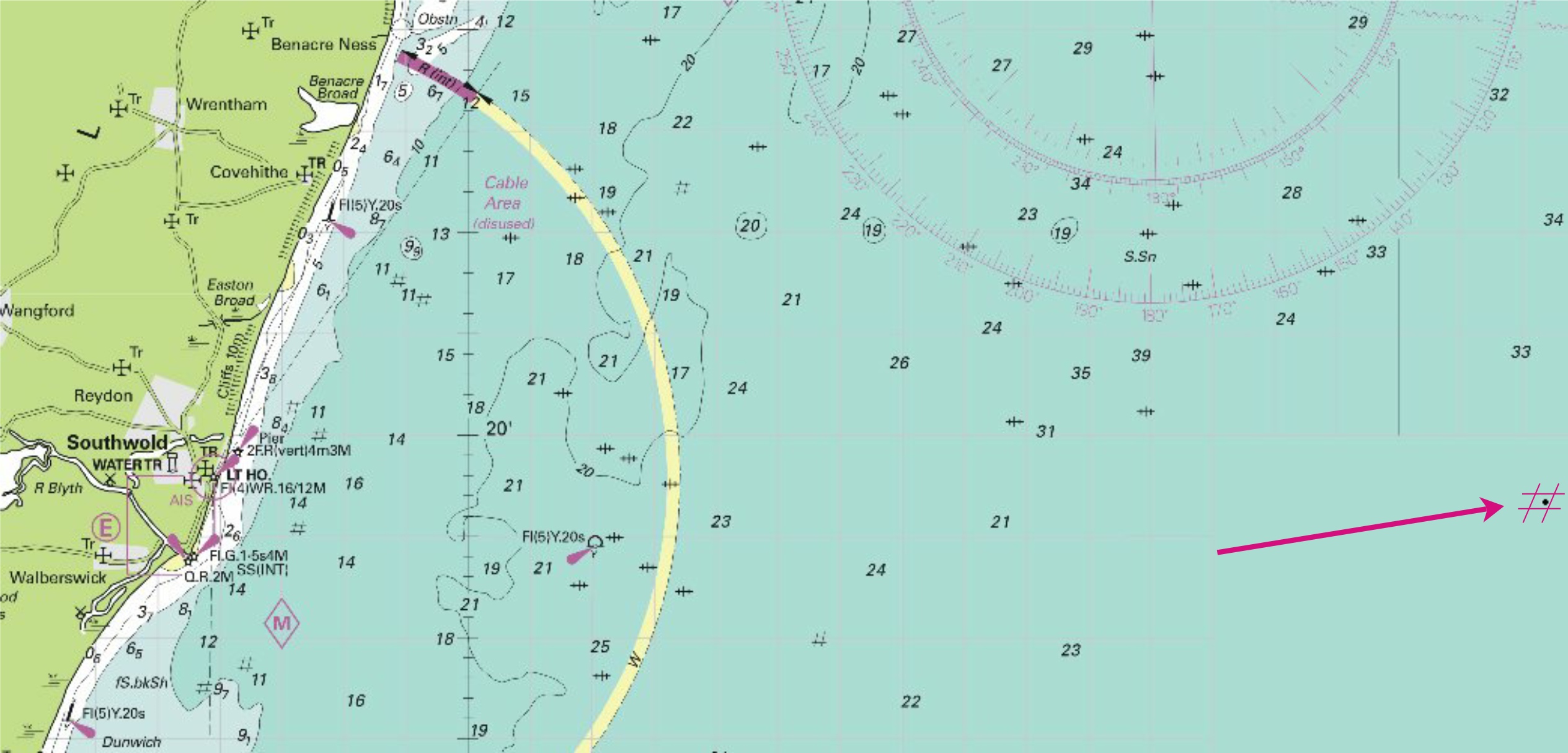
|
2014 Permanent Notices to Mariners - |
||
|
Week 52 |
NETHERLANDS - Insert: Move: to: 51° 41´·92N., 3° 36´·35E. Delete:
|
Affects: UKHO Admiralty Charts: 110 Imray Charts: C30 Three new unlit yellow special marks at the Banjaard off Schouwen. Image courtesy of Imray charts and Meridian ID10. |
|
Week 52 |
ENGLAND - Insert:
|
Affects: UKHO Admiralty Charts: 106, 1408, and 1504 Imray Charts: C28. UKHO Leisure Folios: 5614.6 New wreck found in the Haisborough Gat but the depth will not trouble leisure craft.
Image courtesy of Imray charts and Meridian ID10. |
|
Week 51 |
ENGLAND - Insert pontoon, double firm line, width 9m, joining: (a) 51° 25´·054N., 0° 44´·189E. (existing pontoon) and 51° 25´·086N., 0° 44´·170E. at 51° 25´·040N., 0° 44´·191E. at 51° 25´·085N., 0° 44´·166E. Delete: at 51° 25´·052N., 0° 44´·186E. depth, 27 , close N of: (a) above
Image courtesy of Imray charts and Meridian ID10. |
Affects: UKHO Admiralty Charts: 2572 (panel A, Queenborough) Imray Charts: Y18. UKHO Leisure Folios: 5606.9, 5606.10 Imray Leisure Folios: 2100.3 Note: This update is included in New Editions 1834 and 3683, to be published 11 December 2014. Extension of the ATL at Queenborough.
|
|
Week 51 |
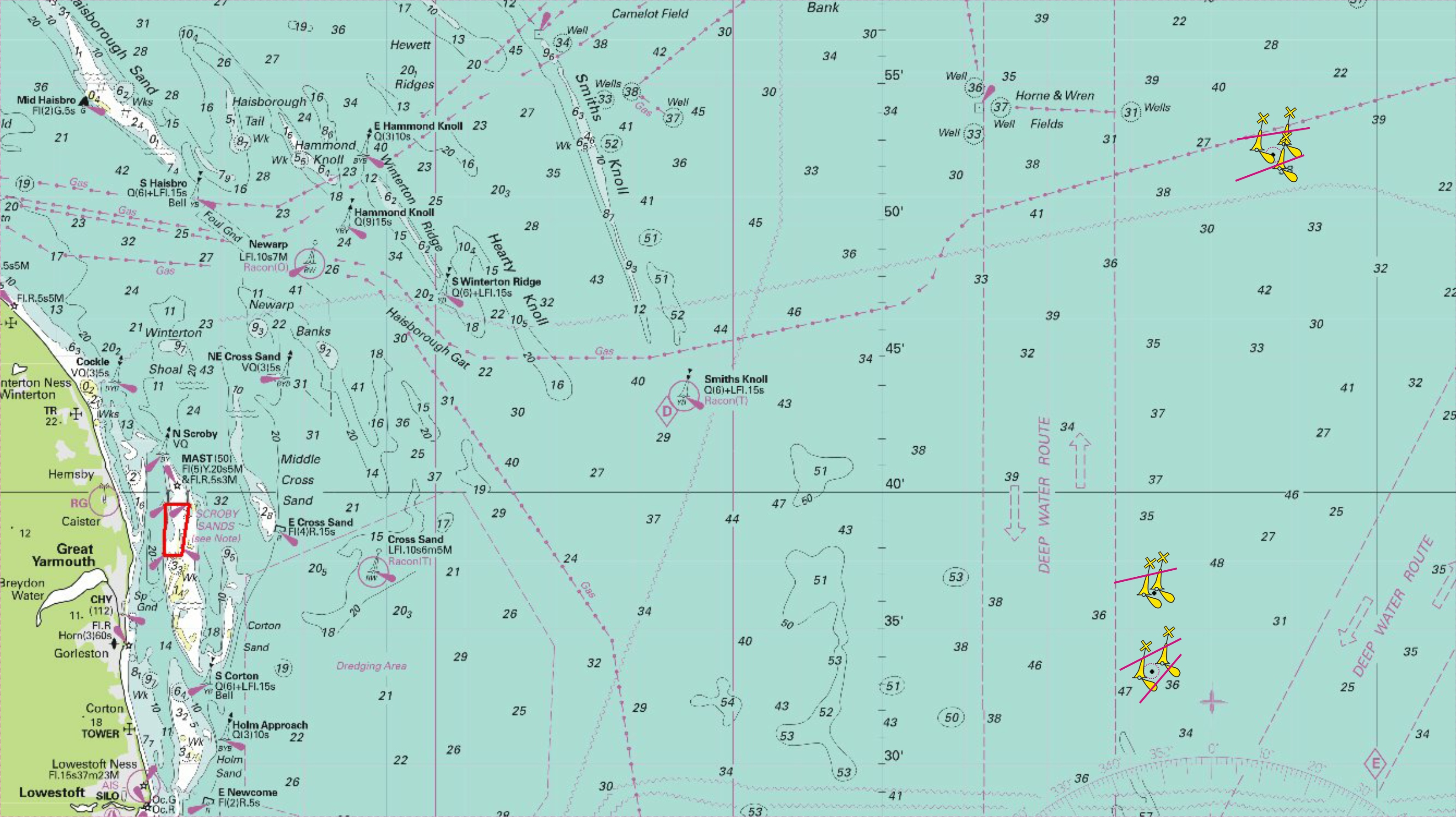
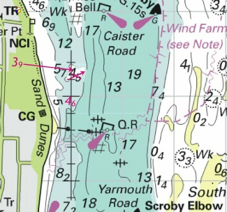
ENGLAND - Insert: depth, 183 , enclosed by 20m contour at 52° 33´·00N., 1° 57´·84E.
Image courtesy of Imray charts and Meridian ID10. |
Affects: UKHO Admiralty Charts: 1543 Imray Charts: C28. UKHO Leisure Folios: 5614.2 A reduction of depth well offshore from Great Yarmouth and still a depth that will not cause leisure users any problem.
|
|
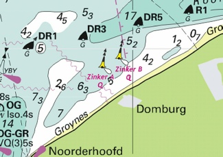
Week 51 |
NETHERLANDS - Source: Netherlands Notice 47/393(T)/14 North cardinal light- Position Designation Characteristic 51° 34´·57N., 3° 28´·89E. Zinker A Q 51° 34´·78N., 3° 29´·50E. Zinker B Q (WGS84 Datum)
Image courtesy of Imray charts and Meridian ID10 |
Affects: UKHO Admiralty Charts: 110, 1872, 1874 Imray Charts: C30. Two new temporary north cardinals in the Roompot.
|
|
Week 50 |
ENGLAND - Insert: depth, 95 , enclosed by 10m contour 51°07´·190N., 1°20´·504E. Replace: depth, 33 , with depth, 21 at 51°07´·495N., 1°20´·097E. depth, 64 , with depth, 57 at 51°07´·478N., 1°20´·146E. depth, 65 , with depth, 56 at 51°07´·498N., 1°20´·218E.
|
Affects: UKHO Admiralty Charts: 1698 Imray Charts: C8. UKHO Leisure Folios: 5605.14A Four reduced depths within Dover Harbour. Seeing one was at a depth likely to hinder leisure craft, I plotted these only to find that three are by the cross-
Image courtesy of Imray charts and Meridian ID10. |
|
Week 50 |
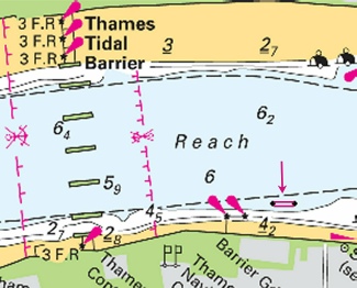
ENGLAND - Insert: pontoon, double firm line, width 5m, joining: 51°29´·749N., 0°02´·595E. and 51°29´·749N., 0°02´·639E.
|
Affects: UKHO Admiralty Charts: 2484D & B, 3337B and 3337 Imray Charts: C2. UKHO Leisure Folios: 5606.14B A new pontoon installed on the eastern side of the Thames Barrier on the northern foreshore.
Image courtesy of Imray charts and Meridian ID10. |
|
Week 50 |
ENGLAND - Insert: depth, 7, and extend 10m contour W to enclose (a) 53°18´·68N., 0°27´·51E. depth, 73 , enclosed by 10m contour 53°18´·63N., 0°26´·96E. depth, 79 , enclosed by 10m contour 53°17´·50N., 0°31´·24E. depth, 72 , and extend 10m contour NW to enclose (b) 53°17´·04N., 0°29´·05E. depth, 2, enclosed by 2m contour 53°15´·44N., 0°32´·92E. depth, 136 , and extend 15m contour SW to enclose 53°11´·45N., 0°33´·01E. depth, 108 , and extend 15m contour N to enclose (c) 53°10´·17N., 0°35´·74E. depth, 13, enclosed by 15m contour 53°09´·47N., 0°33´·82E. depth, 42 , and extend 5m contour N to enclose (d) 53°08´·68N., 0°37´·31E. Replace: depth, 98 , with depth, 84 at 53°12´·51N., 0°35´·39E.
Delete depth, 82 , close E of: (a) above depth, 91 , close SE of: (b) above depth, 121 , close S of: (c) above depth, 52 , close S of: (d) above
|
Affects: UKHO Admiralty Charts: 108 and 1190 Imray Charts: C25. UKHO Leisure Folios: 5614.8 Eleven reductions of depth at the Inner Dowsing.
Image courtesy of Imray charts and Meridian ID10. |
|
Week 50 |
BELGIUM - Insert: depth, 88 (a) at 51°37´·72N., 2°41´·53E. Replace: depth, 137 , with depth, 132 (b) at 51°37´·88N., 2°47´·64E. Delete: depth, 93 , close S of: (a) above depth, 146 , close SE of: (b) above
Image courtesy of Imray charts and Meridian ID10. |
Affects: UKHO Admiralty Charts: 1872 and 2449 Imray Charts: C30. UKHO Leisure Folios: 5614.8 Two reductions in depth on the Belgium banks unlikely to trouble leisure craft.
|
|
Week 49 |
Admiralty Charts to be published 18th December 2014 SC5614 7th Edition - 5614.1 A Orford Ness to Benacre Ness. 1:75,000 B Orford Ness. 1:50,000 5614.2 Lowestoft to Winterton Ness. 1:75,000 5614.3 Approaches to Lowestoft 1:25,000 5614.4 A Approaches to Great Yarmouth. 1:25,000 B Great Yarmouth Outer Harbour. 1:7,500 5614.5 A Northern Approaches to Great Yarmouth. 1:25,000 B Great Yarmouth Haven. 1:7,500 5614.6 A Caister- B Southwold Harbour. 1:7,500 5614.7 A Cromer to Wells- B Wells- 5614.8 Outer Approaches to the Wash. 1:150,000 5614.9 Approaches to the Wash. 1:75,000 5614.10 A The Wash – Eastern Part. 1:37,500 B Continuation of Lynn Cut. 1:37,500 C King’s Lynn. 1:10,000 5614.11 A The Wash – Central Part. 1:37,500 B Continuation of the River Nene. 1:50,000 C Continuation of the River Nene to Wisbech. 1:50,000 5614.12 A The Wash – Western Part. 1:37,500 B Approaches to Boston. 1:20,000 C Boston. 1:10,000 5614.13 Gibraltar Point to Saltfleet. 1:75,000 5614.14 Approaches to the River Humber. 1:75,000 5614.15 River Humber Entrance. 1:37,500 5614.16 Spurn Head to Grimsby Middle. 1:25,000 5614.17 A Approaches to Grimsby. 1:25,000 B Grimsby. 1:10,000 5614.18 A Immingham to Saltend. 1:25,000 B Goole. 1:5,000 5614.19 A Kingston upon Hull to Humber Bridge. 1:25,000 B Humber Bridge to Whitton Ness. 1:50,000 C Hull Docks – Western Part. 1:10,000 5614.20 A Lowestoft Harbour. 1:6,250 B Whitton Ness to Goole and Mere Dyke. 1:50,000 C Continuation to Keadby. 1:50,000 5614.21 Spurn Head to Flamborough Head. 1:150,000 5614.22 A Bridlington to Scarborough. 1:75,000 B Bridlington Harbour. 1:5000 5614.23 A Approaches to Whitby. 1:25,000 B Whitby Harbour. 1:7,500 C Scarborough Bay. 1:10,000 D Scarborough Harbour. 1:5,000 5614.24 Scarborough to Whitby. 1: 75,000 5614.25 Southern North Sea. 1:750,000 |
A New Edition of Leisure Chart Folio SC5614. All sheets have been fully updated for New Editions and Notice to Mariners affecting source charts. |
|
Week 49 |
ENGLAND - Delete: 52° 57´·21N., 0° 21´·44E.
|
Affects: UKHO Admiralty Charts: 108 and 1200 Imray Charts: Y9. This is a deletion of the 180° indicator on the radio reporting point. This point is not displayed on Leisure Folios or Imray charts as it is unlikely to affect leisure craft. No illustration provided. |
|
Week 49 |
BELGIUM - Insert: Obstn at 51° 26´·11N., 3° 03´·74E.
Image courtesy of Imray charts and Meridian ID10. |
Affects: UKHO Admiralty Charts: 1630 Imray Charts: C30. Obstruction at over 7m north of the deep water route into Zeebrugge.
|
|
Week 48 |
Admiralty Charts to be published 11 December 2014 Chart 1834 - Otterham Creek. 1:12,500 Chart 3683 - Sheerness. 1:6,250 |
Includes changes to depths from the latest Medway Port Authority surveys. Includes changes to depths from the latest Medway Port Authority surveys. |
|
Week 48 |
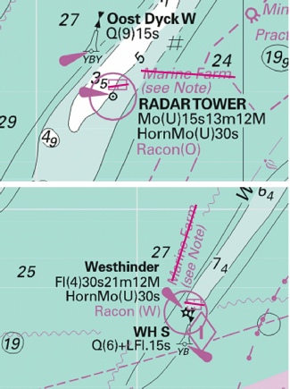
NORTH SEA - As part of the decommissioning of Horne & Wren Gas Fields, work is taking place to remove the Horne & Wren platform in position 52° 54´·19N., 2° 35´·83E. During the platform removal navigational aids on the platform may not be reliable. Underwater seabed obstructions may exist following the removal of the platform until clearance work is complete. The following buoys have been temporarily established to mark the work area: Buoy type Light Position North cardinal, Q at 52° 54´·50N., 2° 35´·91E. East cardinal, Q(3)10s at 52° 54´·23N., 2° 36´·36E. South cardinal, Q(6)+LFl.15s at 52° 53´·96N., 2° 35´·92E. West cardinal, Q(9)15s at 52° 54´·23N., 2° 35´·47E. Charts will be updated when decommissioning work is complete. (WGS84 Datum)
|
Affects: UKHO Admiralty Charts: 1408, 1503, 1504, 1631 and 2182A. Imray Charts: C25. New temporary aids to navigation placed on the four cardinal points of the well head (scale to fine to place images):
Image courtesy of Imray charts and Meridian ID10. |
|
Week 47 |
ENGLAND - Insert
Image courtesy of Imray charts and Meridian ID10. |
Affects: UKHO Admiralty Charts: 1183, 1607 and 1609 Imray Charts: C1. UKHO Leisure Folios: 5606.2 and 5606.5. Imray Leisure Folios: 2100.1. 2100.1 UKHO notification of the PLA NtM L22 of week 44 establishing a weather buoy close to the north-
|
|
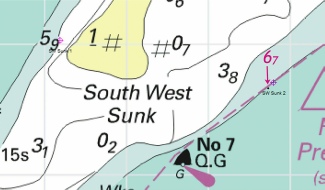
Week 47 |
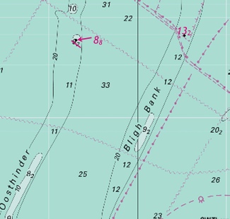
NORTH SEA - Insert
Image courtesy of Imray charts and Meridian ID10. |
Affects: UKHO Admiralty Charts: 1406, 1630 and 2449. Imray Charts: C25. A foul discovered close to the Bligh Bank wind farm in over 20m of water so unlikely to hinder leisure craft.
|
|
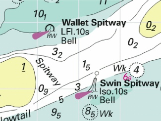
Week 46 |
ENGLAND - Insert: depth, 69 at 51°42´·13N., 1°09´·21E. Delete: depth, 81 , close W of above Replace depth, 135 , with depth, 67 , and extend 10m contour SE to enclose 51°37´·66N., 1°18´·74E.
Images courtesy of Imray charts and Meridian ID10. The PDF file contains both images. |
Affects: UKHO Admiralty Charts: 1183 and 1975 Imray Charts: C1. UKHO Leisure Folios: 5606.2 and 5607.2, 5607.3 Imray Leisure Folios: 2000.1. 2100.1 Two reductions of depth – one just south of the Spitway, the second at the southern end of the SW Sunk swatchway (note these are from my survey in June and therefore my chartlets for download remain valid. Note also that the second image includes my recommended waypoints to cross using the SW Sunk swatchway).
|
|
Week 45 |
No UKHO notices affecting monitored area |
|
|
Week 44 |
Admiralty Leisure Folios published 23 October 2014 SC5607 Thames Estuary, Essex and Suffolk Coast. 10th Edition 5607.1 Orford Ness to Oostende. 1:250,000 5607.2 Foulness Point to Landguard Point. 1:100,000 5607.3 Outer Approaches to the River Blackwater. 1:50,000 5607.4 Southern Approaches to Harwich. 1:50,000 5607.5 Harwich to Orford Ness. 1:50,000 5607.6 A Approaches to Harwich and Woodbridge Haven. 1:25,000 B Continuation of the River Deben. 1:25,000 5607.7 Rivers Stour and Orwell. A River Stour. 1:25,000 B River Orwell. 1:25,000 C Ipswich. 1:10,000 5607.8 A Rivers Ore and Alde. 1:25,000 B Orford Haven and Approaches. 1:25,000 5607.9 West Mersea and Brightlingsea. 1:25,000 5607.10 Harbours on the East Coast. A River Colne. 1:25,000 B Colchester Quays. 1:12,500 C Brightlingsea. 1:12,500 D West Mersea. 1:12,500 5607.11 A River Blackwater, Bradwell to Maldon. 1:25,000 B Bradwell. 1:12,500 C Tollesbury Yacht Harbour. 1:12,500 D Maldon. 1:12,500 5607.12 A Rivers Crouch and Roach. 1:25,000 B Continuation of the River Roach. 1:25,000 5607.13 A Continuation of the River Crouch. 1:25,000 B Burnham- C Entrance to Walton Backwaters. 1:12,500 D Continuation to Battlesbridge. 1:25,000 5607.14 A Walton Backwaters. 1:12,500 B Continuation of Landermere Creek. 1:12,500 |
A New Edition of Leisure Chart Folio SC5607. All sheets have been fully updated for New Editions and Notices to Mariners affecting source charts. |
|
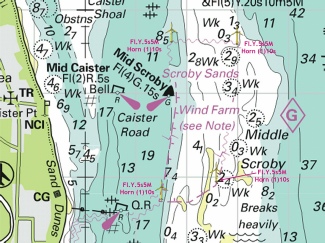
Week 44 |
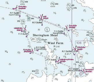
ENGLAND - Amend fog signal to, Horn(1)10s, at the wind turbines at: 52° 39´·56N., 1° 46´·73E. 52° 39´·55N., 1° 47´·98E. 52° 37´·95N., 1° 47´·59E. 52° 37´·76N., 1° 46´·61E.
Image courtesy of Imray charts and Meridian ID10 |
Affects: UKHO Admiralty Charts: 1534 and 1543. Imray Charts: C28. UKHO Leisure Folios: 5614.2 and 5614.6 This is a change in the Fog signal characteristics on the existing lit four corners of the wind farm.
|
|
Week 44 |
ENGLAND - Insert Replace Replace
Image courtesy of Imray charts and Meridian ID10 |
Affects: UKHO Admiralty Charts: 323, 1183, 1406, 1607, 1610, 1828 and 2182A. Imray Charts: C28. UKHO Leisure Folios: 5606.2, 5606.3 and 5606.4 Rationalisation of positions and names of the three PLA Pilot Boarding Stations. The NE Goodwin is new; the names have changed on the other two.
|
|
Week 43 |
NORTH SEA - Insert 52° 23´·14N., 2° 46´·09E.
|
Affects: UKHO Admiralty Charts: 1408, 1504 and 1631. Imray Charts: C25. Dangerous ordnance in the North Sea. Along way out and at 55 metres unlikely to trouble leisure craft!
Image courtesy of Imray charts and Meridian ID10 |
|
Week 43 |
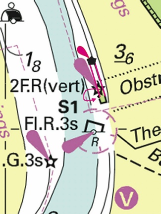
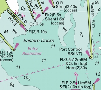
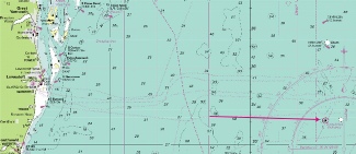
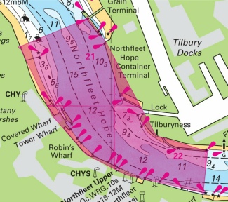
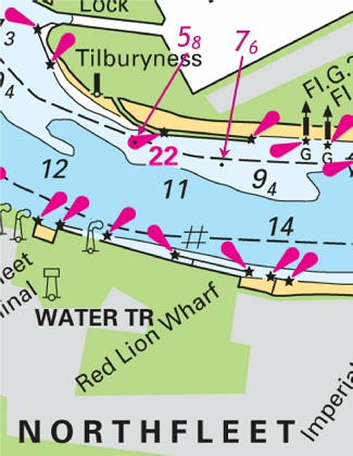
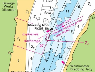
ENGLAND - Insert: limit of precautionary area, pecked line, joining: 51°27´·69N., 0°19´·10E. (shore) 51°27´·87N., 0°19´·77E. (jetty) and 51°26´·79N., 0°20´·92E. (jetty) 51°27´·05N., 0°20´·95E. (jetty) symbol, precautionary area, centred on: 51°27´·399N., 0°19´·881E. legend: TILBURY PRECAUTIONARY AREA (see Note), centred on: 51°27´·312N., 0°19´·883E. TILBURY PRECAUTIONARY AREA Inward and outward bound vessels rounding Tilburyness should be aware of strong tidal sets and the presence of vessels manoeuvring at and swinging for berths in the area, including Tilbury Lock.
|
Affects: UKHO Admiralty Charts: 1186, 2151 and 2484. Imray Charts: C2. UKHO Leisure Folios: 5606.14. New Precautionary Area in the Thames at Tilbury.
Image courtesy of Imray charts and Meridian ID10 |
|
Week 43 |
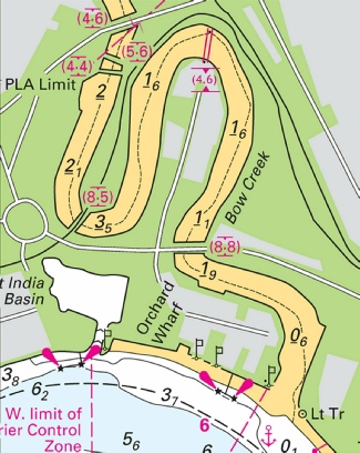
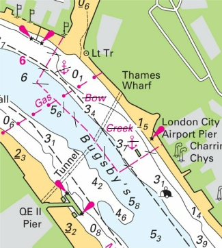
ENGLAND - Insert: bridge, double firm line, width 6m, joining: 51° 30´·872N., 0° 00´·413E. (shore) and (a) 51° 30´·836N., 0° 00´·402E. (shore) symbol, vertical clearance 4·6m, close S of: (a) above
Image courtesy of Imray charts and Meridian ID10 |
Affects: UKHO Admiralty Charts: 3337. Imray Charts: C2. A new bridge over Bow Creek off Bugsby’s Reach, River Thames.
|
|
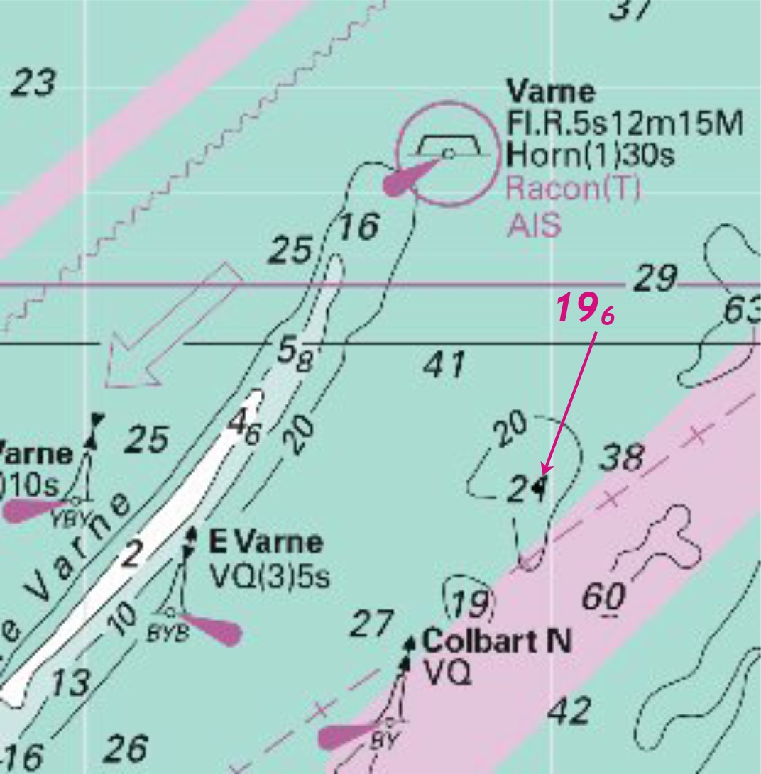
Week 43 |
ENGLAND - Insert:
Image courtesy of Imray charts and Meridian ID10 |
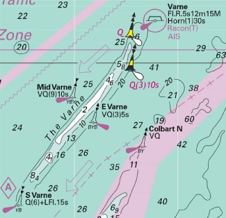
Affects: UKHO Admiralty Charts: 323, 1610, 1892, 2449 and 2451. Imray Charts: C8. UKHO Leisure Folios: 5606.7. Imray Leisure Folios: 2100.6 Confirmation of the Trinity House notice issued in week 37 of two new lighted buoys marking the Varne bank in the English Channel.
|
|
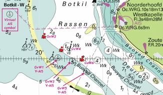
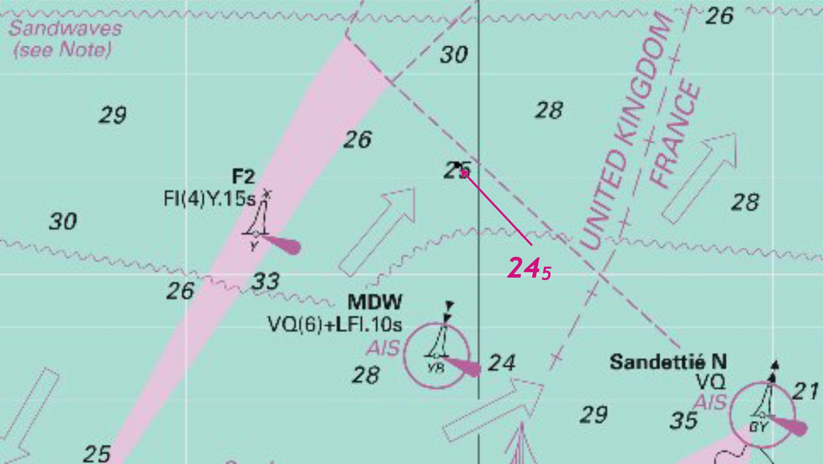
Week 43 |
NETHERLANDS - navigation. Buoyage. Virtual aids to navigation (V- Designation and Position GvW1 at 51° 30´·01N., 3° 21´·50E. GvW3 at 51° 29´·85N., 3° 22´·63E. GvW5 at 51° 29´·30N., 3° 23´·73E. The buoyage in the approaches to Geul van de Walvischstaart has changed. The following charted buoys have beenmoved: Buoy Old position New position GvW2 51° 30´·83N., 3° 20´·20E. to 51° 31´·02N., 3° 20´·39E. GvW4 51° 30´·17N., 3° 22´·08E. to 51° 30´·35N., 3° 21´·77E. GvW6 51° 29´·36N., 3° 23´·80E. to 51° 29´·89N., 3° 23´·36E. (WGS84 Datum)
|
Affects: UKHO Admiralty Charts: 1872 and 1874. Imray Charts: C30. Three new virtual aids to navigation have been added to the buoyage marking the Geul van de Walvischstaart channel approach to the Westerschelde. The charted symbol is:
The three adjacent port hand buoys which actually exist have been moved slightly.
Images courtesy of Imray charts and Meridian ID10 |
|
Week 42 |
ENGLAND - Insert: depth, 58 at 53° 06´·57N., 0° 45´·85E. depth, 36 and extend 5m contour NW to enclose 53° 06´·15N., 0° 44´·23E. depth, 35 at (a) 53° 05´·62N., 0° 49´·06E. depth, 65 at (b) 53° 04´·15N., 0° 52´·48E. depth, 107 at (c) 53° 04´·41N., 0° 55´·47E. Delete: depth, 6, close NW of: (a) above depth, 39 , close SE of: (a) above depth, 88 , close SE of: (b) above depth, 131 , close E of: (c) above
|
Affects: UKHO Admiralty Charts: 108, 1190 and 1503. Imray Charts: Y9. UKHO Leisure Folios: 5614.7 (last three) Five reduction in depths on the Burnham Flats
Images courtesy of Imray charts and Meridian ID10 |
|
Week 42 |
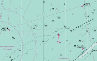
NETHERLANDS - Replace the depth, at 51°50´·03N., 3°18´·50E. with 153
|
Affects: UKHO Admiralty Charts: 110, 1406, 1408 and 1630. Imray Charts: C30. Reduction of depth on the West Buitenbanken (inshore western approach to the Hook of Holland). Unlikely to hinder leisure craft.
Images courtesy of Imray charts and Meridian ID10 |
|
Week 41 |
Admiralty Charts to be published 23 October 2014 New Editions of Admiralty Leisure Folios SC5607 10th Edition Thames Estuary, Essex and Suffolk Coast. 5607.1 Orford Ness to Oostende. 1:250,000 5607.2 Foulness Point to Landguard Point. 1:100,000 5607.3 Outer Approaches to the River Blackwater. 1:50,000 5607.4 Southern Approaches to Harwich. 1:50,000 5607.5 Harwich to Orford Ness. 1:50,000 5607.6 A Approaches to Harwich and Woodbridge Haven. 1:25,000 B Continuation of the River Deben. 1:25,000 5607.7 Rivers Stour and Orwell. A River Stour. 1:25,000 B River Orwell. 1:25,000 C Ipswich. 1:10,000 5607.8 A Rivers Ore and Alde. 1:25,000 B Orford Haven and Approaches. 1:25,000 5607.9 West Mersea and Brightlingsea. 1:25,000 5607.10 Harbours on the East Coast. A River Colne. 1:25,000 B Colchester Quays. 1:12,500 C Brightlingsea. 1:12,500 D West Mersea. 1:12,500 5607.11 A River Blackwater, Bradwell to Maldon. 1:25,000 B Bradwell. 1:12,500 C Tollesbury Yacht Harbour. 1:12,500 D Maldon. 1:12,500 5607.12 A Rivers Crouch and Roach. 1:25,000 B Continuation of the River Roach. 1:25,000 5607.13 A Continuation of the River Crouch. 1:25,000 B Burnham- C Entrance to Walton Backwaters. 1:12,500 D Continuation to Battlesbridge. 1:25,000 5607.14 A Walton Backwaters. 1:12,500 B Continuation of Landermere Creek. 1:12,500 |
A New Edition of Leisure Chart Folio SC5607. All sheets have been fully updated for New Editions and Notice to Mariners affecting source charts. |
|
Week 41 |
ENGLAND - Insert: depth, 58 (a) at 51° 27´·043N., 0° 20´·576E. depth, 76 (b) at 51° 27´·000N., 0° 20´·853E. Delete: depth, 63 , close S of: (a) above depth, 81 , close N of: (b) above depth, 91 , close S of: (b) above
Images courtesy of Imray charts and Meridian ID10 |
Affects: UKHO Admiralty Charts: 1186 and 2151. Imray Charts: C2. UKHO Leisure Folios: 5606.14. Two new depths on the north side of Gravesend Reach, River Thames. These depths should not trouble leisure craft.
|
|
Week 41 |
FRANCE - The approach channel to Dunkerque Port Ouest has changed and buoyage has been moved as follows: Buoy - RCW from 51° 01´·23N., 1° 45´·35E. to 51° 01´·00N., 1° 45´·84E. RCA from 51° 00´·90N., 1° 48´·72E. to 51° 01´·00N., 1° 48´·53E. DKA from 51° 02´·55N., 1° 56´·96E. to 51° 02´·57N., 1° 57´·00E. DYCK from 51° 02´·98N., 1° 51´·76E. to 51° 02´·93N., 1° 51´·76E. RCE from 51° 02´·45N., 1° 53´·23E. to 51° 02´·32N., 1° 52´·95E. Yellow conical buoy from 51° 02´·32N., 1° 53´·34E. to 51° 02´·19N., 1° 53´·06E. Yellow conical buoy from 51° 02´·32N., 1° 52´·93E. to 51° 02´·20N., 1° 52´·67E. DW5 from 51° 02´·20N., 2° 00´·93E. to 51° 02´·23N., 2° 00´·82E. DW6 from 51° 02´·61N., 2° 01´·04E. to 51° 02´·83N., 2° 00´·74E. DW7 from 51° 02´·55N., 2° 02´·59E. to 51° 02´·41N., 2° 02´·39E. DW8 from 51° 02´·77N., 2° 02´·58E. to 51° 03´·00N., 2° 02´·21E. DW9 from 51° 02´·67N., 2° 04´·04E. to 51° 02´·60N., 2° 03´·96E. DW10 from 51° 03´·00N., 2° 04´·13E. to 51° 03´·19N., 2° 03´·78E. DW11 from 51° 02´·87N., 2° 05´·77E. to 51° 02´·79N., 2° 05´·53E. DW12 from 51° 03´·19N., 2° 05´·57E. to 51° 03´·38N., 2° 05´·36E. DW13 from 51° 03´·05N., 2° 07´·10E. to 51° 02´·98N., 2° 07´·10E. DW14 from 51° 03´·36N., 2° 07´·15E. to 51° 03´·56N., 2° 06´·93E. DW16 from 51° 03´·30N., 2° 08´·98E. to 51° 03´·52N., 2° 08´·62E. Mariners are advised to navigate with caution in the area. Charts will be updated when full details become available.
|
Affects: UKHO Admiralty Charts: 323, 1350, 1351, 1873 and 1892. Imray Charts: C30. UKHO Leisure Folios: 5605.2 and 5605.10. These are changes to buoy positions in the Chenal Intermediaire leading to the Port Quest of Dunkerque. It is not possible to produce an image of the changes. Generally the layout of the buoyage has not changed. Some moves are very small but the general trend is to move the starboard hand buoys west a little and the port hand buoys north thus increasing the width of the buoyed channel for large shipping. It is suggested that the PDF be printed to ensure that any relevant waypoints are updated. |
|
Week 41 |
ENGLAND - Buoyage. Insert:
Amend: light- Replace: 51°29´·73N., 0°37´·81E. Move:
51°29´·42N., 0°40´·86E. to: 51°29´·48N., 0°40´·87E. Delete:
|
Affects: UKHO Admiralty Charts: 1185. Imray Charts: C2. UKHO Leisure Folios: 5606.7 and 5606.8. UKHO confirmation of changes in the Yantlet Channel and environs announced by PLA NtM L16 in week 38.
Image is copyright CTTE and available for download as a PDF |
|
Week 40 |
Admiralty Charts to be published 2nd October 2014 Chart 1543 England - |
Includes changes to depths from the latest British Government, Great Yarmouth Port Authority, ABP Lowestoft and Trinity House surveys. |
|
Week 40 |
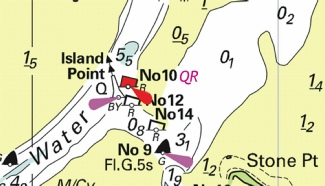
ENGLAND - Replace No 10 with Q.R No 10 at 51°53´·389N., 1°15´·383E.
|
Affects: UKHO Admiralty Charts: 2695. Imray Charts: Y16. UKHO Leisure Folios: 5607.14. Imray Leisure Folios: 2000.4 The N0 10 port hand buoy (opposite the Island Point north cardinal buoy) at the entrance to the Walton Channel is now lit.
Images courtesy of Imray charts and Meridian ID10 |
|
Week 40 |
ENGLAND - Delete:
|
Affects: UKHO Admiralty Charts: 106, 108, 1190, 1408 and 1503. Imray Charts: C29. UKHO Leisure Folios: 5607.14. Removal of buoyage around the now complete Sheringham Shoal Wind Farm. This leaves the wind Farm marked by lights on the turbine on each corner of the Farm and one intermediate turbine on each side.
Image is copyright of the UKHO. |
|
Week 40 |
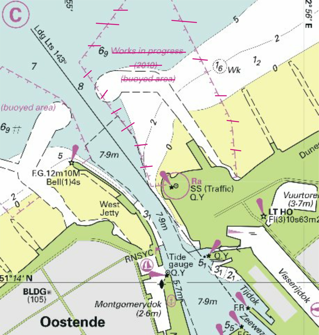
BELGIUM - Insert:
Delete:
Images courtesy of Imray charts and Meridian ID10 |
Affects: UKHO Admiralty Charts: 323, 1872, 1873, 1874, and 2449. Imray Charts: C30. Insertion of a new wreck at just over 5m depth to the north-
|
|
Week 39 |
No UKHO notices affecting monitored areas |
|
|
Week 38 |
ENGLAND - Insert: depth, 19 , and extend 2m contour S to enclose (a) 51° 23´·171N., 000° 30´·931E. Delete: depth, 25 , close NW of: (a) above
|
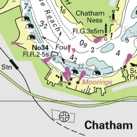
Affects: UKHO Admiralty Charts: 1835 and 2482. Imray Charts: Y18. UKHO Leisure Folios: 5606.11. A significant depth reduction at the beginning of Limehouse Reach, Chatham, River Medway.
Images courtesy of Imray charts and Meridian ID10 |
|
Week 38 |
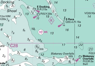
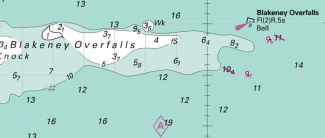
ENGLAND - Insert at 53° 06´·60N.,000° 51´·95E.
|
Affects: UKHO Admiralty Charts: 108, 1190 and 1503. Imray Charts: C25. UKHO Leisure Folios: 5614.7 A wreck at 10 metres off the Blakeney Overfalls. Should not trouble leisure craft.
Images courtesy of Imray charts and Meridian ID10 |
|
Week 38 |
ENGLAND - Delete: 1. limit of anchorage area, pecked line, and associated legend, 51° 30´·45N., 0° 00´·52E. (shore) 51° 30´·36N., 0° 00´·44E. 51° 30´·20N., 0° 00´·68E. 51° 30´·25N., 0° 00´·81E. (shore) reference, Bow Creek at 51°30’·31 0°00’·61 2 Hours, within the DESIGNATED ANCHORAGE AREAS table, centred on: 51° 27´·00N., 0° 28´·90E.
|
Affects: UKHO Admiralty Charts: 2484 and3337 Imray Charts: C2. UKHO Leisure Folios: 5606.15. Deletion of the designated anchorage at Bow Creek, in Bugsby’s Reach, River Thames.
Images courtesy of Imray charts and Meridian ID10 |
|
Week 38 |
ENGLAND - Insert: depth, 39 , and extend 5m contour NW to enclose (a) 52° 38´·28N., 1° 45´·06E. depth, 46 , enclosed by 5m contour (b) 52° 37´·91N., 1° 45´·01E. Delete: depth, 45 , close SE of: (a) above depth, 9, close SE of: (b) above
Note: This update is included in New Edition 1543, published 2 October 2014
|
Affects: UKHO Admiralty Charts: 1534. Imray Charts: C28. UKHO Leisure Folios: 5614.2 Two reductions of depth in Caister Road, Great Yarmouth.
Images courtesy of Imray charts and Meridian ID10 |
|
Week 37 |
Admiralty Charts to be published 25 September 2014 Chart 1975 England - |
Includes changes from the latest British Government, Port of London Authority and commercial surveys. Also includes changes to lights, wrecks and cables. |
|
Week 37 |
ENGLAND - Delete:
|
Affects: UKHO Admiralty Charts: 1183, 1185, 1609. Imray Charts: C1. UKHO Leisure Folios: 5606.7. Imray Leisure Folios: 2100.2 Removal of the two yellow buoys on the southern edge of the Shoeburyness LW line.
Images courtesy of Imray charts and Meridian ID10 |
|
Week 37 |
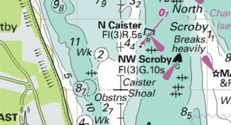
South East Coast of England - On or about 29th September, 2014. New stations to be established: 1. Varne N. E. Lighted Buoy, position 50° 59’.800N., 001° 22’.700E. Characteristics: Pillar: Black above yellow above black: Q(3)10 seconds: E. Cardinal topmark. 2. Varne N. W. Lighted Buoy, position 51° 00'.800N., 001° 22’.700E. Characteristics : Pillar: Black above yellow: Q: N. Cardinal topmark.
|
Trinity House Notices to Mariners 27 of 2014. Affects: UKHO Admiralty Charts: 2449. Imray Charts: C8. UKHO Leisure Folios: 5606.7. Imray Leisure Folios: 2100.6 Advanced notice of the intention to place two new cardinal marks on the Varne bank in the Dover Straits
Images courtesy of Imray charts and Meridian ID10 |
|
Week 36 |
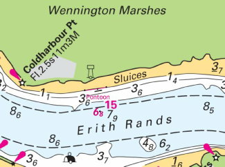
ENGLAND - Insert: 0m low water line, joining: (a) 51° 29´·247N., 0° 11´·732E. (existing contour), 51° 29´·254N., 0° 11´·827E. and (b) 51° 29´·263N., 0° 11´·891E. (existing contour) pontoon, single firm line, joining: 51° 29´·249N., 0° 11´·816E. and (c) 51° 29´·251N., 0° 11´·838E. depth, 68 at (d) 51° 29´·151N., 0° 11´·843E. legend, Pontoon, close E of: (c) above Delete: former 0m low water line, joining: (a) above and (b) above depth, 82 , close SW of: (d) above
|
Affects: UKHO Admiralty Charts: 2151. Imray Charts: C2. UKHO Leisure Folios: 5606.14. New depths and a new pontoon at the Erith Rands. The change in the low water line is barely noticeable at the usual chart scale.
Images courtesy of Imray charts and Meridian ID10 |
|
Week 36 |
ENGLAND - Insert depth, 07 , enclosed by 2m contour at 52° 40´·59N., 1° 45´·49E.
Images courtesy of Imray charts and Meridian ID10 |
Affects: UKHO Admiralty Charts: 1534 and 1543. Imray Charts: C28. UKHO Leisure Folios: 5614.6. Reduction of depth on the Caister Shoal
|
|
Week 35 |
No permanet notices affecting monitored areas this week |
|
|
Week 34 |
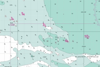
ENGLAND - Insert: depth, 1, enclosed by 2m contour at 53°02´·79N., 0°54´·83E. depth, 96 , and extend 10m contour E to enclose (a) 53°02´·69N., 1°02´·06E. depth, 97 , enclosed by 10m contour (b) at 53°01´·98N., 1°01´·34E. Delete: depth, 113 , close SW of: (a) above depth, 107 , close E of: (a) above depth, 104 , close NW of: (b) above
|
Affects: UKHO Admiralty Charts: 108, 1190 and 1503. Imray Charts: C25, C28. UKHO Leisure Folios: 5614.7. Three reductions of depths at the Blakeney Overfalls.
Images courtesy of Imray charts and Meridien ID10 |
|
Week 34 |
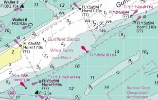
ENGLAND - Replace: 1. symbol, wind turbine, Fl.Y.2·5s5M (R Lts), with symbol, wind turbine, Fl.Y.2·5s2M (R Lts) 51°44´·74N., 1°17´·43E. 2. symbol, wind turbine, Fl.Y.5s2M (R Lts), with symbol, wind turbine, Fl.Y.5s5M (R Lts) at 51°43´·51N., 1°14´·98E. 3. symbol, wind turbine, Fl.Y.5s5M Horn(1)10s (R Lts), with symbol, wind turbine, Fl.Y.2·5s2M (R Lts) at 51°42´·48N., 1°12´·36E. 4. symbol, wind turbine, Fl.Y.2·5s2M, with symbol, wind turbine, Fl.Y.5s5M (a) at 51°42´·22N., 1°11´·70E. Insert fog signal, Horn(1)10s, at wind turbine (a) above
|
Affects: UKHO Admiralty Charts: 1183 and 1975. Imray Charts: C1. UKHO Leisure Folios: 5607.2. Imray Leisure Folios 2000.1 Additional lights on the Gunfleet Sands Wind Farm and two changes to existing lights. Note that the addition in the south-
Images courtesy of Imray charts and Meridien ID10 |
|
Week 34 |
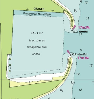
ENGLAND - Amend light to, Q.G.17m3M at 52°34´·71N., 1°44´·74E. light to, Q.R.17m3M at 52°34´·60N., 1°44´·73E.
Images courtesy of Imray charts and Meridien ID10 |
Affects: UKHO Admiralty Charts: 1534, 1535. Imray Charts: C28. UKHO Leisure Folios: 5614.4. Change of height and range on the Great Yarmouth harbour lights.
|
|
Week 34 |
ENGLAND - Insert at (a) 51°56´·942N., 1°11´·734E. Delete:
51°56´·941N., 1°11´·936E. 51°56´·944N., 1°12´·054E. 51°56´·957N., 1°12´·247E.
Images courtesy of Imray charts and Meridien ID10 |
Affects: UKHO Admiralty Charts: 1594. Imray Charts: Y16. UKHO Leisure Folios: 5607.7. Imray Leisure Folios: 2000.5 Removal of 6 mooring buoys and placement on one in the River Stour off Copperas Bay
|
|
Week 34 |
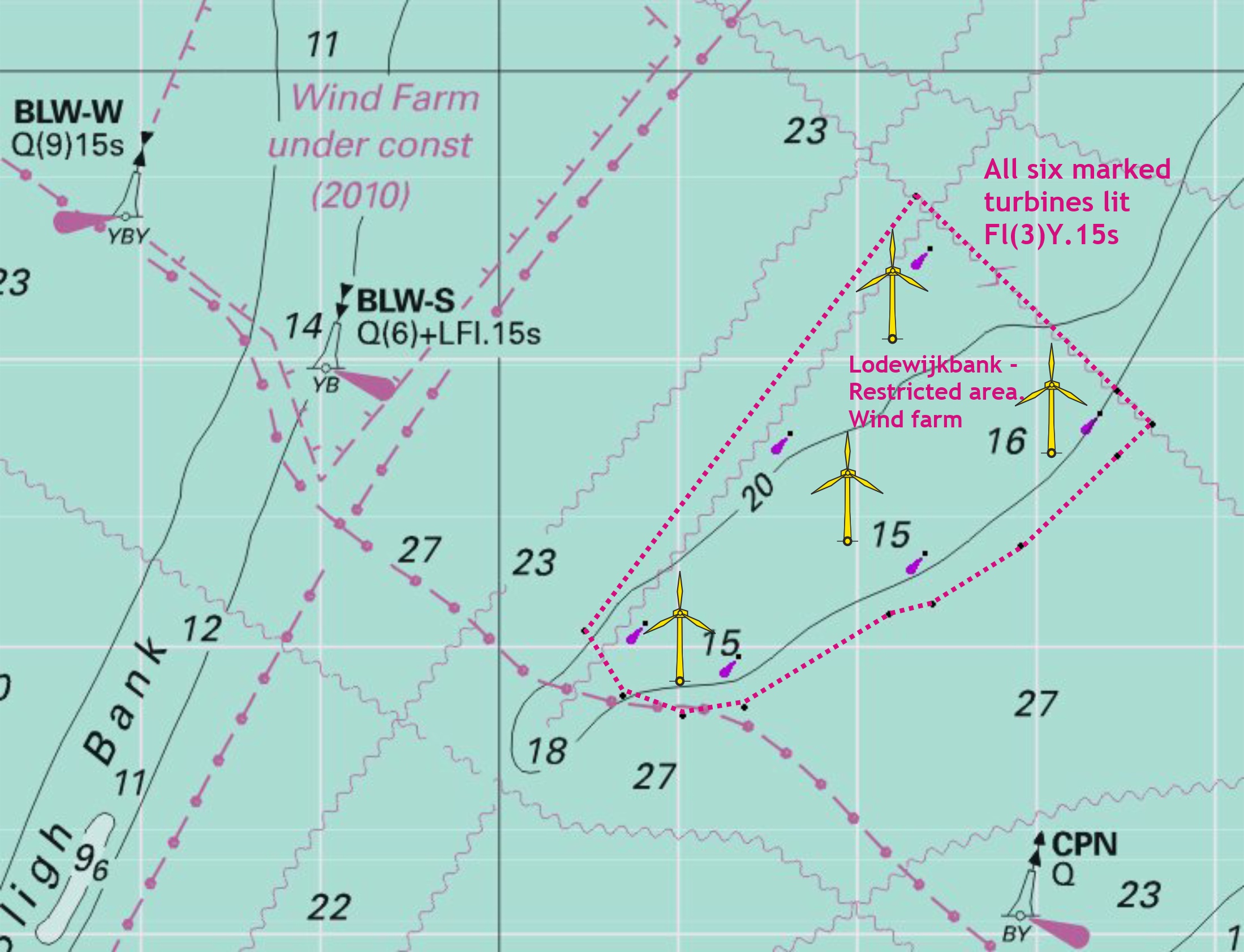
BELGIUM - Legends. Insert limit of restricted area, entry prohibited, pecked line, joining: 51°37´·78N., 2°56´·92E. (W border) 51°37´·33N., 2°56´·92E. (W border) Insert limit of restricted area, entry prohibited, pecked line, joining: (a) 51°39´·13N., 2°54´·67E. (b) 51°37´·55N., 2°57´·31E. (c) 51°36´·70N., 2°55´·83E. (d) 51°36´·30N., 2°54´·85E. (e) 51°36´·23N., 2°54´·36E. (f) 51°35´·58N., 2°52´·74E. (g) 51°35´·52N., 2°52´·05E. (h) 51°35´·66N., 2°51´·38E. (i) 51°36´·11N., 2°50´·96E. (j) 51°39´·13N., 2°54´·67E. symbol, wind farm, within: (a)- symbol, wind turbine, Fl(3)Y.15s at 51°37´·41N., 2°53´·16E. 51°36´·09N., 2°51´·54E. 51°35´·86N., 2°52´·57E. 51°36´·58N., 2°54´·66E. 51°37´·55N., 2°56´·61E. 51°38´·69N., 2°54´·72E. 51°36´·14N., 2°51´·58E. legend, Historic Wreck, at wreck: 51°22´·72N., 2°43´·36E. legend, Historic Wk, at wreck: 51°22´·86N., 2°27´·13E.
|
Affects: UKHO Admiralty Charts: 110, 1406, 1630, 1872, 1873, 1874 and 2449. Imray Charts: C30. UKHO Leisure Folios: 5606.13. Formal notification of the restricted area that is the Lodewijkbank Wind farm. Note that in Belgium waters it is not permitted to transit through wind farms.
Notification of two Historic Wrecks
Images courtesy of Imray charts and Meridien ID10 |
|
Week 34 |
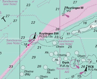
FRANCE - Move Fl(3)G.12s Ruytingen SW and associated Automatic Identification System, AIS, from: 51° 05´·01N., 1° 46´·74E. to: 51° 04´·33N., 1° 45´·84E.
Images courtesy of Imray charts and Meridien ID10 |
Affects: UKHO Admiralty Charts: 323, 1406, 1610, 1892 and 2449. Imray Charts: C8, C30. UKHO Leisure Folios: 5605.2, 5606.1. Imray Leisure Folios: 2100.6 A move of the Ruytingen Sw starboard hand buoy to the south-
|
|
Week 33 |
ENGLAND - Insert: depth, 25 at (a) 51° 30´·49N., 0° 32´·28E. depth, 52 at (b) 51° 30´·483N., 0° 33´·439E. depth, 64 at (c) 51° 30´·479N., 0° 33´·381E. depth, 73 at (d) 51° 28´·603N., 0° 27´·085E. Replace depth, 146 , with depth, at 135 at 51° 30´·311N., 0° 30´·669E. Delete: depth, 45 , close SW of: (a) above depth, 28 , close N of: (a) above depth, 79 , close SE of: (b) above depth, 73 , close NW of: (c) above depth, 81 , close NE of: (d) above Images courtesy of Imray Charts and Meridien ID10 |
Affects: UKHO Admiralty Charts: 1185, 1186 and 2484. Imray Charts: C2. UKHO Leisure Folios: 5606.13. A range of new depths in the River Thames near Hole Haven, Coryton and Hope Reach. Those near the wharfs on the north side of the River are in areas that leisure craft should not be using. The new depth in Hope Reach is an increase and will not affect leisure craft.
|
|
Week 32 |
No permanent notices affecting monitored areas |
|
|
Week 31 |
ADMIRALTY CHARTS TO BE PUBLISHED 14 AUGUST 2014 Chart 2693- A Continuation Of River Stour. 1:25,000 B Ipswich 1:10,000 C Continuation Of River Deben. 1:25,000 |
Includes changes to depths from the latest ABP Ipswich, Harwich Haven Authority and Trinity House surveys. |
|
Week 31 |
ENGLAND - Insert: drying height, 0 9 , enclosed by 0m low water line 52° 36´·95N., 1° 46´·78E. depth, 12 , enclosed by 2m contour (a) 52° 36´·79N., 1° 48´·57E. drying height, 1 , and extend 0m low water line W to enclose 53° 36´·34N., 1° 46´·93E. drying height, 0 2 , enclosed by 0m low water line 52° 35´·97N., 1° 47´·84E. drying height, 0 1 , and extend 0m low water line SW to enclose (b) 52° 34´·17N., 1° 47´·74E. depth, 48 , enclosed by 5m contour (c) 52° 30´·99N., 1° 49´·01E. drying height, 0 5 , enclosed by 0m low water line 52° 30´·49N., 1° 47´·47E. Delete: depth, 29 , close S of: (a) above depth, 81 , close NW of: (b) above depth, 67 , close S of: (c) above
Notices 3039 and 3196 refer
Images courtesy of Imray Digital Charts and Meridien ID10. |
Affects: UKHO Admiralty Charts: 1534, 1535 and 1543. Note: This update is included in New Editions 1534 and 1535, published 10th July 2014. Imray Charts: C25, C28, C29. UKHO Leisure Folios: 5614.2, 5614.3, 5614.4. This is a partial correction of a notice in week 29. All the corrections are brought into one place here with these two images showing changes in depth off Great Yarmouth and Lowestoft.
|
|
Week 31 |
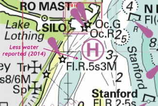
ENGLAND - Insert legend, Less water reported (2014), centred on: 52°27´·90N., 1°45´·26E.
Image courtesy of Imray Digital Charts and Meridien ID10 |
Affects: UKHO Admiralty Charts: 1535. Imray Charts: C25, C28, C29. UKHO Leisure Folios: 5614.3. Less water reported – no further details within Lowestoft South Road on the inside of the Newcome Sand.
|
|
Week 30 |
No permanet notices affecting monitored areas this week |
|
|
Week 29 |
No permanet notices affecting monitored areas this week |
Note that there is one notice affecting the monitored area but it contains typographical errors and will be replaced with a revised notice as soon as possible |
|
Week 28 |
ENGLAND - Insert: depth, 94 at (a) 51° 58´·15N., 1° 27´·57E. depth, 53 , enclosed by 7m contour at (b) 51° 58´·09N., 1° 27´·15E.
Delete: depth, 99 , close NW of: (a) above depth, 86 , close E of: (b) above depth, 88 , close E of: (c) above
|
Affects: UKHO Admiralty Charts: 2693. Imray Charts: C1. UKHO Leisure Folios: 5605.1. Imray Leisure Folios: 2000.3, 2000.4. UKHO previously notified reduced depths and obstructions to the south and south-
Image courtesy of Imray Charts and Meridien ID10. |
|
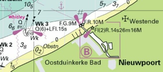
Week 28 |
BELGIUM - Amend designation of the north cardinal buoy Oostduinkerke to, Whitley 51° 09´·15N., 2° 39´·44E.
Image courtesy of Imray Charts and Meridien ID10. |
Affects: UKHO Admiralty Charts: 1872, 1873 and 2449. Imray Charts: C30 Admiralty Leisure Folios: 5605.11 Change of name to the north cardinal buoy north-
|
|
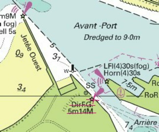
Week 28 |
FRANCE - Delete Dir F.G.5m and associated sector 50° 57´·99N., 1° 50´·74E.
Image courtesy of Imray Charts and Meridien ID10. |
Affects: UKHO Admiralty Charts: 1351. Imray Charts: C8. UKHO Leisure Folios: 5605.12. Removal of the light on the inner harbour entrance at Calais (which is mainly intended as a leading light from the lock from Basin Carnot).
|
|
Week 27 |
ENGLAND - Insert: drying height, 0 2 , and extend 0m low water line SW to enclose 52° 02´·30N., 1° 27´·73E. drying height, 2 1 , enclosed by 0m low water line (a) at 52° 02´·17N., 1° 27´·84E. Delete depth, 04 , close N of: (a) above Insert the accompanying block, showing amendments to depths, drying heights, drying contours, coastline and slipway, centred on: 52° 02´·3N., 1° 28´·00E. |
Affects: UKHO Admiralty Charts: 2693 and 2695. Imray Charts: C1. UKHO Leisure Folios: 5607.5. Imray Leisure Folios: 2000.1, 2000.2, 2000.3 UKHO block replacement for the Ore entrance.
Image is Crown Copyright |
|
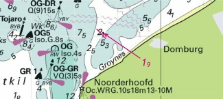
Week 27 |
NETHERLANDS - Insert depth, 19 , enclosed by 2m contour (a) 51° 34´·11N., 3° 27´·35E. Delete depth, 26 , close N of: (a) above
|
Affects: UKHO Admiralty Charts: 110, 1630, 1872 and 1874. Imray Charts: C30. Small reduction of depth in the shallows off the Noorderhoofd on the coast of Walcheren
Image courtesy of Imray Charts and Meridien ID10. |
|
Week 26 |
Admiralty Charts to be published 10 July 2014 Chart 1534 - A Great Yarmouth Outer Harbour. 1:7,500 B Great Yarmouth Haven. 1:7,500 Chart 1535 - Lowestoft Harbour. 1:6250 |
Includes changes to depths from the latest British Government, Trinity House and Great Yarmouth Port Authority surveys. Includes changes to depths from the latest British Government, Trinity House and Great Yarmouth Port Authority surveys. |
|
Week 26 |
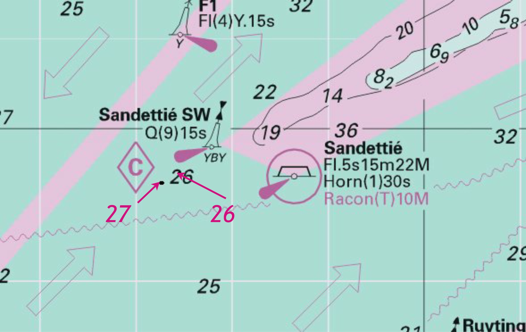
ENGLAND - Source: Port of London Authority Delete Obstn at 51°29´·47N., 0°52´·56E.
Image courtesy of Imray Charts and Meridien ID10. |
Affects: UKHO Admiralty Charts: 1185, 1607 and 1609. Imray Charts: C1. UKHO Leisure Folios: 5606.2, 5606.7 Imray Leisure Folios: 2100.1, 2100.2 Slightly mystified by this one as it repeats part of Notice 1063 of week 10 of this year. Obstruction at 12.4m by Sea Reach No 1. Not likely to hinder leisure craft.
This is a repeat of the week 10 image. Note the magenta ’12.8’ sounding is an additional part of that earlier notice. |
|
Week 26 |
BELGIUM - Source: Belgian Notice 10/170/14 and Netherlands Notice 22/198/14 Insert submarine power cable, 51° 37´·19N., 2° 55´·07E. (existing cable) 51° 38´·18N., 2° 56´·15E. (existing cable) and 51° 40´·76N., 2° 51´·78E. (existing cable) 51° 40´·42N., 2° 50´·96E. 51° 41´·47N., 2° 49´·51E.
|
Affects: UKHO Admiralty Charts: 1406, 1630, 1872 and 2449. Imray Charts: C30. This notice links with Notice 2354 of week 23 which inserted the southern part of the new power cable from the Wind Farm on the Lodewijkbank. Yellow line represents the power cable inserted by Notice 2354 (see the image under that week for continuation to the shore). Magenta line represents this weeks insertion.
Image courtesy of Imray Charts and Meridien ID10. |
|
Week 26 |
FRANCE - Source: French Notice 19/27/14 Insert: depth, 137 at (a) 51° 27´·59N., 2° 14´·75E. depth, 146 at 51° 28´·27N., 2° 15´·75E.
Replace Delete: depth, 153 , close NE of: (a) above depth, 33, close SW of: (b) above
|
Affects: UKHO Admiralty Charts: 323, 1406, 1610, 1630, 1872, 1873, 2182 and 2449. Imray Charts: C30. A whole range of obstructions and revised depths on the Fairy Bank but all are at a depth that will not hinder leisure craft.
Image courtesy of Imray Charts and Meridien ID10. |
|
Week 25 |
ENGLAND - Delete
|
Affects: UKHO Admiralty Charts: 1491, 2693. Imray Charts: Y16. UKHO Leisure Folios: 5607.6. Imray Leisure Folios: 2000.5. Deletion of a light on the west terminal of Felixstowe. A similar and very close light has been previously deleted by NtM 591 of 2013.
Image courtesy of Imray Charts and Meridien ID10. |
|
Week 24 |
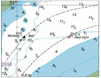
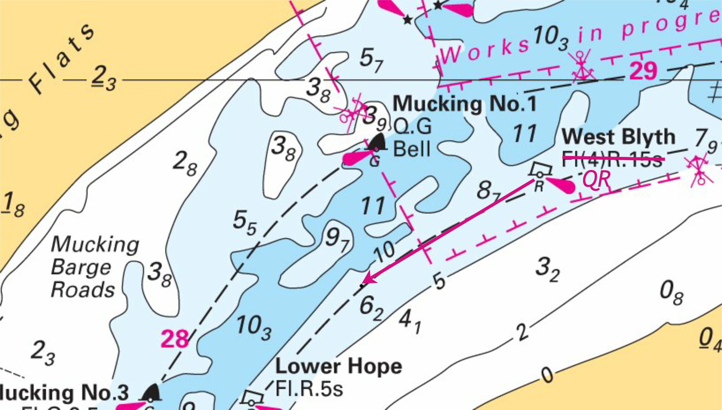
ENGLAND - New block, showing amendments to buoyage, centred on: 51° 29´·765N., 0° 28´·521E.
|
Affects: UKHO Admiralty Charts: 1186 and 2484. Imray Charts: C2. UKHO Leisure Folios: 5606.13. This is confirmation of the permanent siting of the West Blyth PHB and Mucking No 1 SHB following the completion of the works at the London Gateway.
Image is Crown Copyright and is included in the download of the original notice |
|
Week 24 |
ENGLAND - Insert
|
Affects: UKHO Admiralty Charts: 323 and 1828. Imray Charts: C8. UKHO Leisure Folios: 5605.8. Imray Leisure Folios: 2100.6 A new FOUL position approximate in The Downs in water sufficiently deep that it will not trouble leisure craft.
Image courtesy of Imray Charts and Meridien ID10. |
|
Week 23 |
Admiralty Charts to be published 19 JUNE 2014 Chart 2052 (INT1560) International Chart Series, England - |
Includes changes to depths from latest British Government and Trinity House surveys. |
|
Week 23 |
ENGLAND - Insert: depth, 145 at (a) 51° 49´·22N., 1° 36´·90E. drying height, 19 , enclosed by 0m low water line at (b) 51° 46´·81N., 1° 35´·66E. depth, 16 , enclosed by 2m contour at (c) 51° 37´·41N., 1° 26´·16E. Replace: depth, 41 , with depth, 25 at 51° 45´·26N., 1° 37´·60E. Delete depth, 148 , close N of: (a) above depth, 13 , close NW of: (b) above depth, 41 , close N of: (c) above
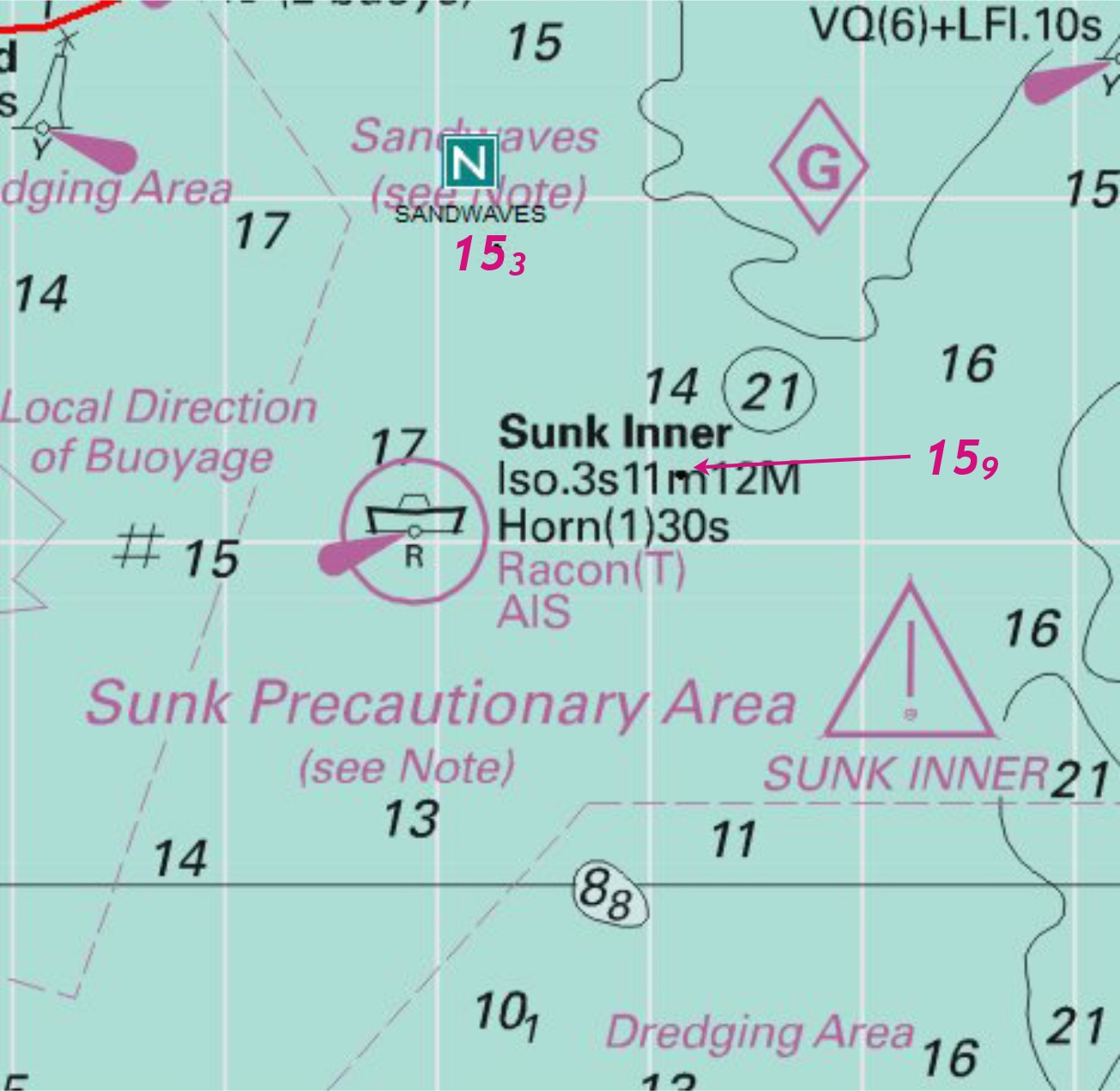
Image courtesy of Imray Charts and Meridien ID10. Left click to enlarge; right click to download. |
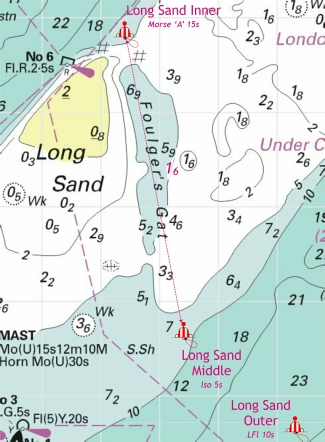
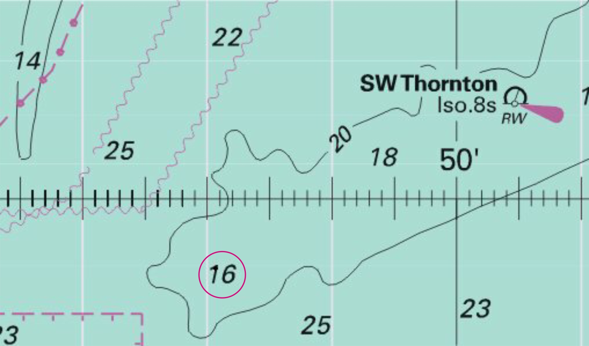
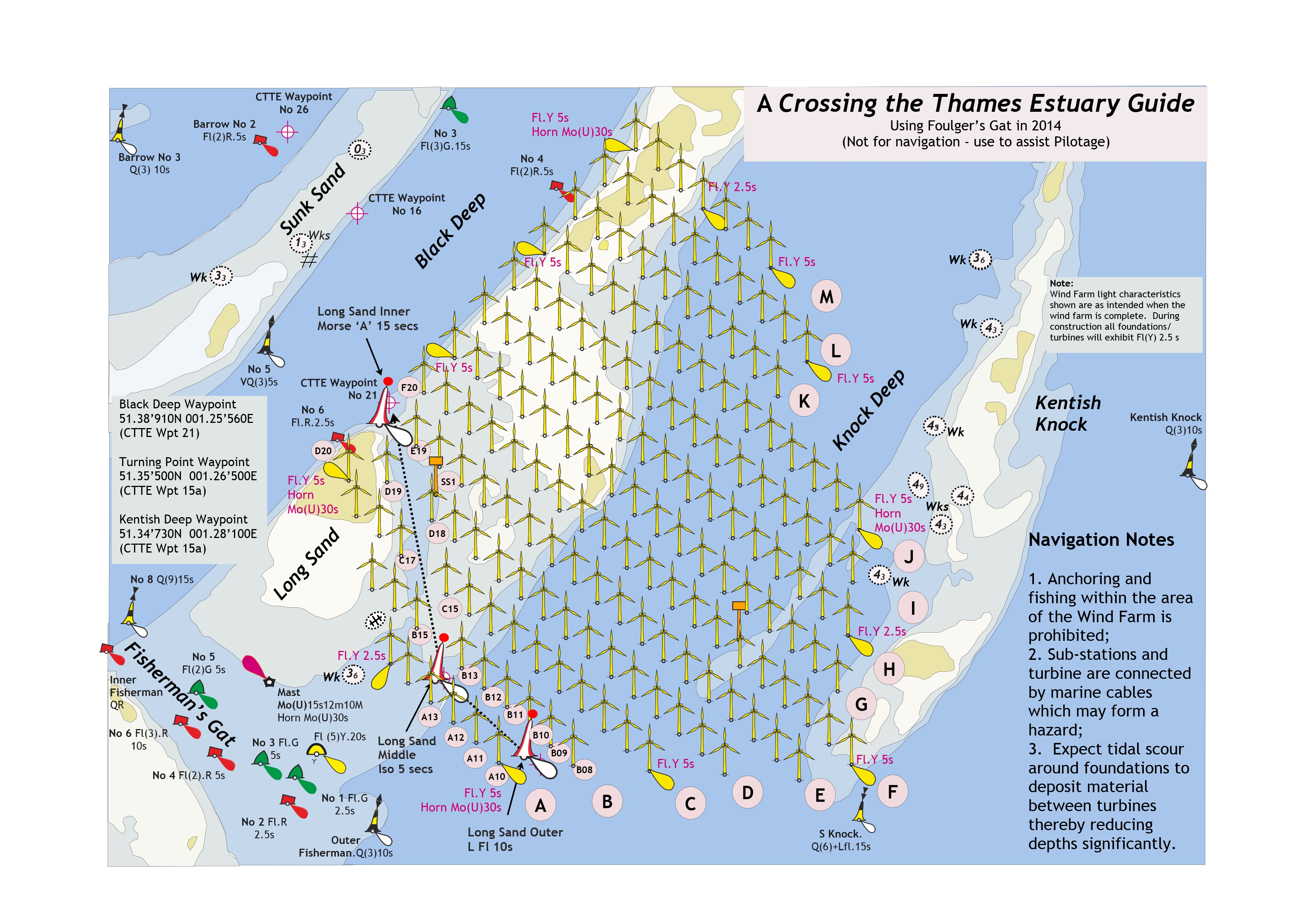
Affects: UKHO Admiralty Charts: 1183, 1610 and 1975. Imray Charts: C1. UKHO Leisure Folios: 5606.2. Imray Leisure Folios: 2000.1, 2100.1 Four new depths: one near the Trinity south cardinal at the sunk Inner, two on Long Sand Head and one adjacent to the eastern side of Foulger’s Gat. The new depth at Trinity is sufficiently deep not to trouble leisure craft. The two on Long Sand Head confirm that this is not a place for leisure craft (or commercial shipping for that matter). The new depth on the edge of Foulger’s Gat is to the eastern edge. At present it is away from the direct line between the two safe water marks but nevertheless worth noting.
|
|
Week 23 |
NORTH SEA - Insert submarine power cable, 51°37´·52N., 2°57´·19E. 51°37´·52N., 2°56´·93E. (W border) 51°37´·19N., 2°55´·07E. 51°37´·15N., 2°57´·81E. (N border) 51°37´·15N., 2°56´·30E. (N border) 51°37´·15N., 2°55´·14E. (N border) 51°36´·93N., 2°55´·79E. 51°35´·41N., 3°00´·70E. 51°32´·15N., 3°02´·03E. (S border) 51°32´·96N., 3°01´·40E. 51°31´·88N., 3°02´·24E. 51°30´·66N., 3°03´·66E. 51°29´·30N., 3°05´·78E. 51°29´·07N., 3°05´·93E. 51°24´·94N., 3°06´·56E. 51°23´·65N., 3°06´·54E. 51°22´·20N., 3°08´·15E. (S border) 51°20´·45N., 3°09´·92E. (W border) 51°20´·37N., 3°10´·02E. 51°19´·75N., 3°10´·52E. (Shore)
Image courtesy of Imray Charts and Meridien ID10. Left click to enlarge; right click to download. |
Affects: UKHO Admiralty Charts: 110, 1406, 1630, 1872, 1874 and 2449. Imray Charts: C30. A new power cable through the Belgium wind farms to Zeebrugge. Closely follows some existing power cables.
|
|
Week 22 |
Admiralty Charts to be published 12 June 2014 Chart 108 England - Wells- |
Includes significant safety- |
|
Week 22 |
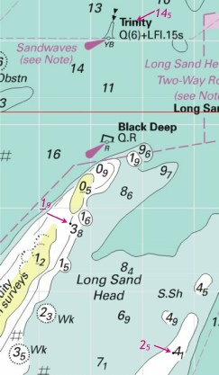
Notice 2279 - Source: Trinity House Notice 15/14 Chart 1183 ETRS89 DATUM Insert:
Chart 1606 ETRS89 DATUM Insert: Chart 1607 ETRS89 DATUM Insert:
Chart 1975 ETRS89 DATUM Insert:
|
Affects: UKHO Admiralty Charts: 1183, 1606, 1607 and 1975. Imray Charts: C1. UKHO Leisure Folios: 5606.2. Imray Leisure Folios: 2000.1, 2100.1 Reinstatement of the Long Sand Inner and Outer safe water buoys as announced by Trinity House in week 15 plus the placement of a new safe water mark at the corner within the avenue that is now Foulger’s Gat.
Image courtesy of Imray Charts and Meridien ID10. Left click to enlarge; right click to download. |
|
Week 22 |
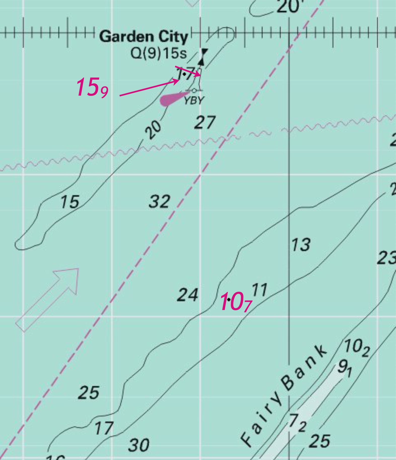
Notice 2188 - Source: Netherlands Notice 18/171/14 Chart 1630 WGS84 DATUM Insert: 20m contour, joining: (a) 51° 24´·09N., 2° 42´·31E. (existing contour) (b) 51° 23´·52N., 2° 42´·42E. (existing contour) and (c) 51° 24´·14N., 2° 44´·57E. (existing contour) 51° 23´·80N., 2° 44´·70E. (d) 51° 23´·52N., 2° 44´·14E. (existing contour) Replace: depth, 163 , with depth, 159 at 51° 29´·42N., 2° 17´·65E. depth, 114 , with depth, 107 at 51° 26´·23N., 2° 18´·65E. Delete former 20m contour, joining: (a) above, (c) above and (b) above, (d) above |
Affects: UKHO Admiralty Charts: 1630. Imray Charts: C30. Extension of the 20m contour at the Goote Bank near the GZ south cardinal buoy. Indicated sounding is from the NtM 2121 from last week.
Slight reduction of depths on the Fairy Bank near the Garden City West Cardinal Buoy and further to the west.
Images courtesy of Imray Charts and Meridien ID10. Left click to enlarge; right click to download. |
|
Week 21 |
Notice 2120 - Source: Brightlingsea Harbour Commissioners Notice 1/14 Chart 1975 ETRS89 DATUM Insert Chart 3741 (panel A, Brightlingsea) ETRS89 DATUM Delete Chart 3741 ETRS89 DATUM Insert Delete at 51° 47´·86N., 1° 00´·66E. |
Affects: UKHO Admiralty Charts: 1975 and 3741. Imray Charts: C1. UKHO Leisure Folios: 5607.3, 5607.9. Imray Leisure Folios: 2000.7. New pilot boarding position for Brightlingsea and the Colne
Image courtesy of Imray Charts and Meridien ID10. Left click to enlarge, right click to download. |
|
Week 21 |
Notice 2166 - Source: UKHO Chart 2482 (panel, Continuation of the Swale) ETRS89 DATUM Delete legend, Cable works in progress (2012), centred on: 51°22´·34N., 0°57´·67E. |
Affects: UKHO Admiralty Charts: 2482. Imray Charts: C1. UKHO Leisure Folios: 5607.3, 5607.9. Imray Leisure Folios: 2100.4. This is a deletion of the caution about cable work inserted at Shell Ness on the Swale back in 2012 for the London Array Wind Farm work. No illustration considered necessary. |
|
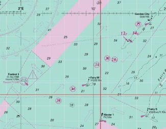
Week 21 |
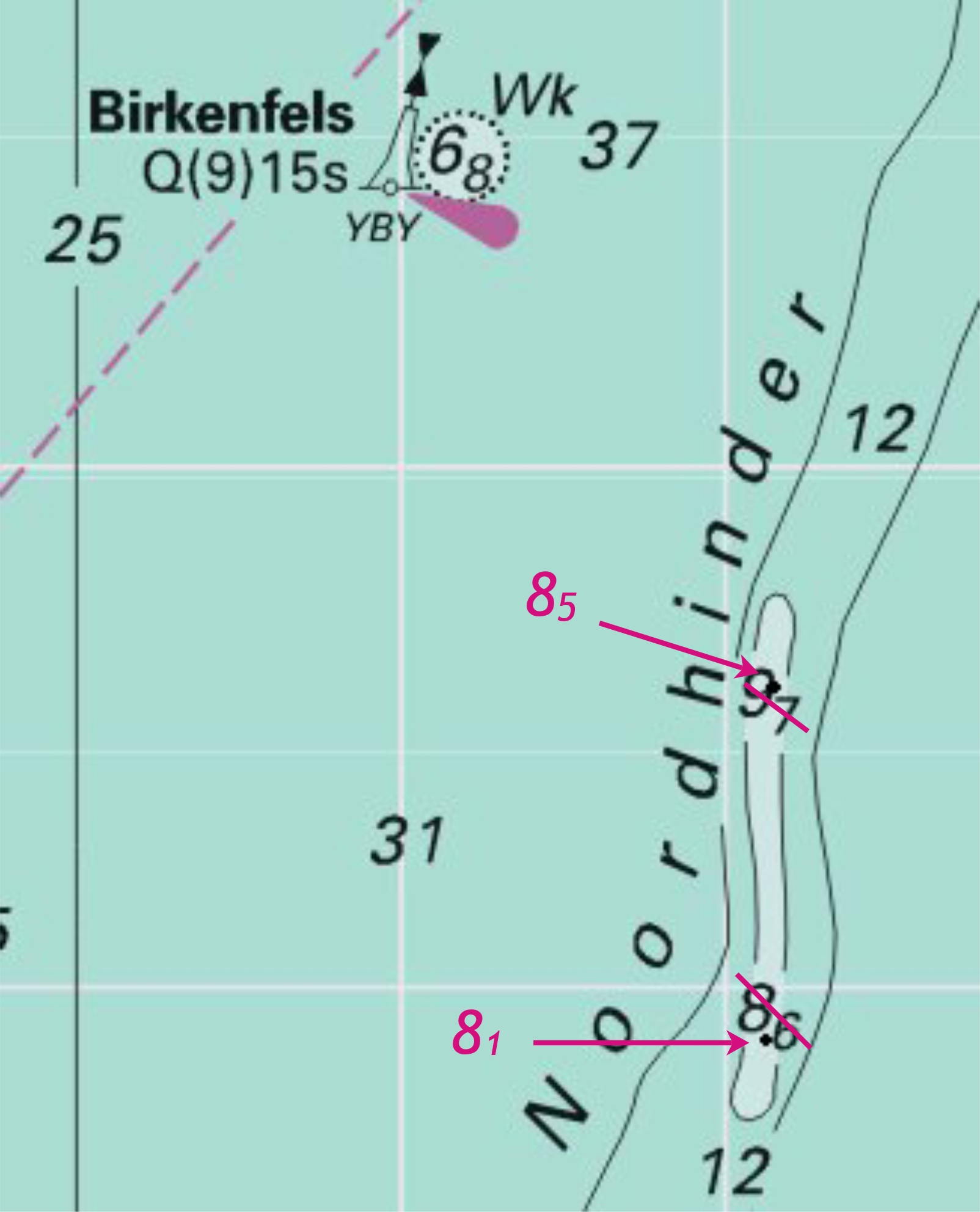
Notice 2121 - Source: Belgian Notices 8/147- Chart 1406 WGS84 DATUM Insert: depth, 81 at (a) 51°35´·80N., 2°34´·25E. depth, 184 , and extend 20m contour S to enclose 51°23´·85N., 2°43´·70E. Delete depth, 86 , close NE of: (a) above Chart 1630 WGS84 DATUM Insert: depth, 81 at (a) 51°35´·81N., 2°34´·23E. depth, 169 at (b) 51°26´·73N., 2°34´·52E. depth, 184 , and extend 20m contour SE to enclose 51°23´·85N., 2°43´·70E. Delete: depth, 85 , close S of: (a) above depth, 186 , close N of: (b) above Chart 1872 WGS84 DATUM Insert: depth, 85 at (a) 51°37´·15N., 2°34´·29E. depth, 81 at (b) 51°35´·81N., 2°34´·23E. depth, 169 at (c) 51°26´·73N., 2°34´·52E. depth, 184 , and extend 20m contour S to enclose 51°23´·85N., 2°43´·70E. depth, 16 at 51°29´·30N., 2°46´·15E. Delete: depth, 96 , close S of: (a) above depth, 85 , close S of: (b) above depth, 186 , close N of: (c) above Chart 1873 WGS84 DATUM Insert: depth, 169 at (a) 51°26´·73N., 2°34´·52E. depth, 184, and extend 20m contour SE to enclose 51°23´·85N., 2°43´·70E. Delete depth, 186 , close N of: (a) above Chart 1874 WGS84 DATUM Insert: depth, 184 , and extend 20m contour SE to enclose 51°23´·85N., 2°43´·70E. depth, 16 at (a) 51°29´·30N., 2°46´·15E. Delete depth, 175 , close S of: (a) above Chart 2449 WGS84 DATUM Insert: depth, 81 at (a) 51°35´·81N., 2°34´·23E. depth, 169 (b) 51°26´·73N., 2°34´·52E. depth, 184 , and extend 20m contour SE to enclose 51°23´·85N., 2°43´·70E. Replace depth, 97 , with depth, 85 at 51°37´·15N., 2°34´·32E. Delete: depth, 86 , close NE of: (a) above depth, 192 , close E of: (b) above |
Affects: UKHO Admiralty Charts: 1406, 1630, 1872, 1873, 1874, 2449. Imray Charts: C30. An eclectic mix of a reduction of 5 new depths in various positions over the Belgium banks. None should particularly trouble leisure craft.
Image courtesy of Imray Charts and Meridien ID10. Left click to enlarge, right click to download. |
|
Week 20 |
Notice 2038 - Source: Port of London Authority Charts 1183, 1606, 1607 and 1975 ETRS89 DATUM Replace |
Affects: UKHO Admiralty Charts: 1183, 1606, 1607 and 1975. Imray Charts: C1. UKHO Leisure Folios: 5606.2. Imray Leisure Folios: 2100.1. Another of the 1950’s beacons has given way, this time the NW Long sand beacon. Only the Cant and Girdler beacons of this series remain and those are already ruins. The NW Long sand had its uses as a clearing line when crossing the SW Sunk swatchway – now sadly no longer visible. The wreckage is probably least of our worries as nobody in their right mind would venture over the top of the NW Long Sand. Quite close to the remains (sunken) of Radio Caroline of course.
Image courtesy of Imray Charts and Meridien ID10. Left click to enlarge, right click to download. |
|
Week 19 |
Admiralty Charts to be published 22 May 2014 Chart 1698 - |
Includes changes to depths from the latest Dover Harbour Board surveys. |
|
Week 19 |
Notice 1926 - Source: Harwich Haven Authority Notice 9/14 Charts 1491 and 2693 ETRS89 DATUM Insert legend, Works in progress (2014-
|
Affects: UKHO Admiralty Charts: 1491 and 2693. Imray Charts: C28, Y16. UKHO Leisure Folios: 5607.5, 5607.6. Imray Leisure Folios: 2000.5. UKHO confirmation of the recent Harwich Haven Authority notice of extended works on the container berths at Felixstowe.
Image courtesy of Imray Charts and Meridien ID10. Left click to enlarge, right click to download. |
|
Week 19 |
Notice 1986 - Source: Trinity House Charts 1610, 2052, 2693 and 2695 (panel C, Rivers Ore and Alde) ETRS89 DATUM Move |
Affects: UKHO Admiralty Charts: 1610, 2052, 2693 and 2695. Imray Charts: C1. UKHO Leisure Folios: 5607.5. Imray Leisure Folios: 2000.1, 2000.2, 2000.3 ‘Seasonal’ move of the Orford Haven Bell buoy. For all the Orford changes please see East Coast Pilot’s Imray image:
For download go here: http://www.eastcoastpilot.com/downloads.html |
|
Week 19 |
Notice 1919 - Source: Belgian Notice 7/130/14 Charts 1872 and 1874 WGS84 DATUM Delete |
Affects: UKHO Admiralty Charts: 1872 and 1874. Imray Charts: C30. Removal of a yellow special buoy off Zeebrugge.
Image courtesy of Imray Charts and Meridien ID10. Left click to enlarge, right click to download. |
|
Week 18 |
Admiralty Charts to be published 1 May 2014 Chart 128 - A Baalhoek to Antwerp. 1:30,000 B Antwerp to Hoboken. 1:15,000 C Hoboken to Wintam. 1:10,000 Note: This chart remains affected by Notice 5162(T)/13. Chart 2571 England - A Faversham Creek. 1:12,500 B Whitstable Harbour. 1:5,000 |
Includes changes to depths from the latest Netherlands Government and Belgian Government surveys and changes to coastline. Includes changes to depths from the latest British Government and Medway Port Authority Surveys. |
|
Week 18 |
Notice 1807 - Source: Great Yarmouth Port Authority Chart 1534 (panel A, Great Yarmouth Outer Harbour) ETRS89 DATUM Insert depth, 57 at (a) 52° 34´·562N., 1° 44´·499E. Delete depth, 67 , close E of: (a) above |
Affects: UKHO Admiralty Chart: 1534. Imray Charts: C28C. UKHO Leisure Folios: 5614.4. This is a new reduced depth in the Outer Harbour so unlikely to trouble leisure craft.
Image courtesy of Imray Charts and Meridien ID10. Left click to enlarge, right click to download. |
|
Week 18 |
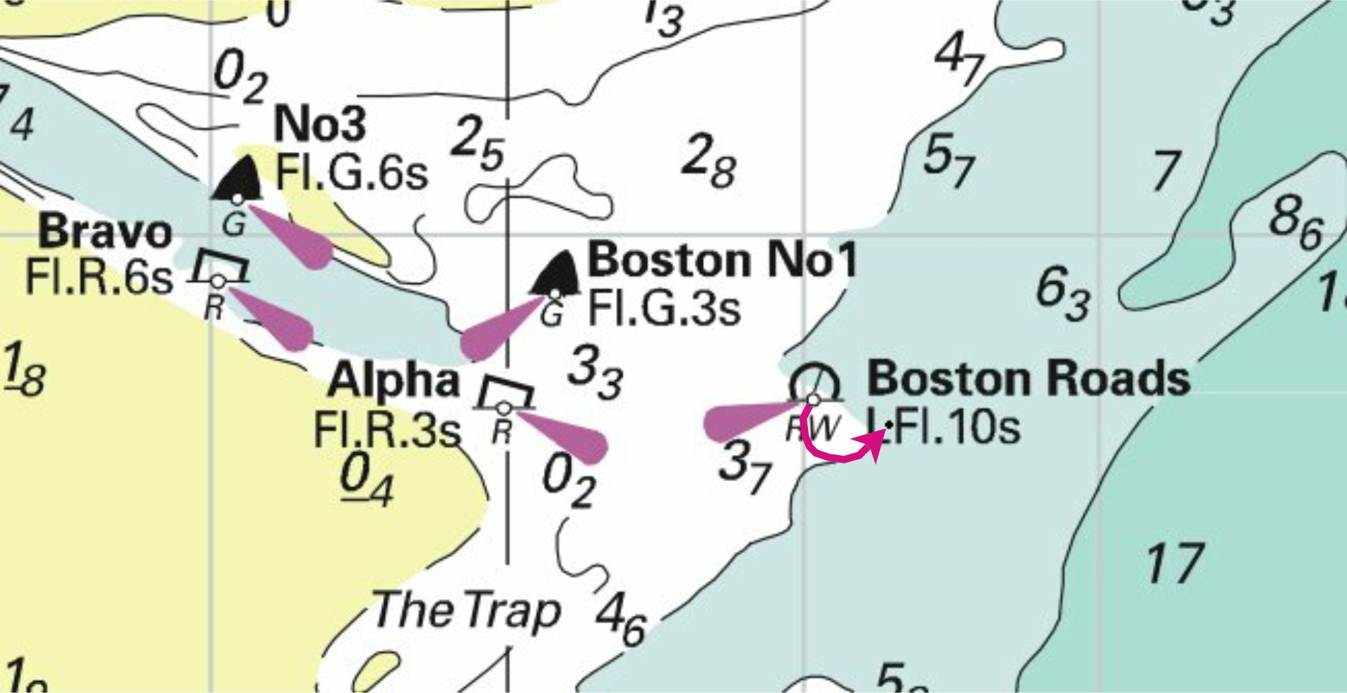
Notice 1821 - Source: Port of Boston Charts 108 and 1200 ETRS89 DATUM Move |
Affects: UKHO Admiralty Charts: 108 and 1200. Imray Charts: Y9. UKHO Leisure Folios: 5614.9. Small move of the Boston Road safe water buoy.
Image courtesy of Imray Charts and Meridien ID10. Left click to enlarge, right click to download. |
|
Week 18 |
Notice 1833 - Source: Belgian Notice 7/126/14 Charts 1872 (panel A, Nieuwpoort) and 1873 (panel B, Nieuwpoort) WGS84 DATUM Delete
leading line, pecked and firm line, and associated legend, 175°, extending in direction 355° from (a) above. |
Affects: UKHO Admiralty Charts: 1872 and 1873. Imray Charts: C30. UKHO Leisure Folios: 5605.12. Removal of the two leading lights leading up the River Yzer beyond the marinas.
Image courtesy of Imray Charts and Meridien ID10. Left click to enlarge, right click to download. |
|
Week 17 |
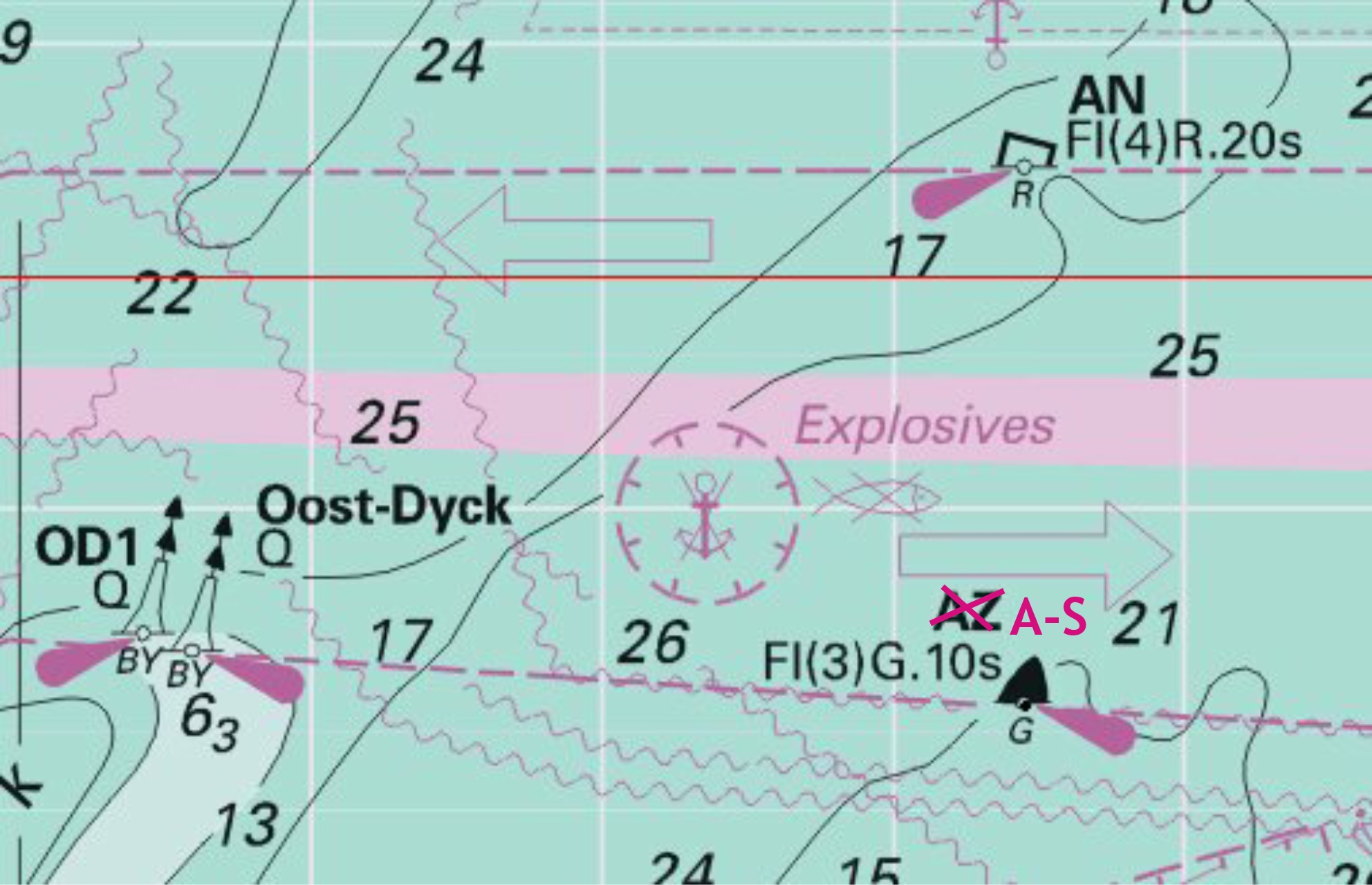
Notice 1736 - Source: Belgian Notice 6/105/14 Charts 1406, 1872, 1873 and 2449 WGS84 DATUM Insert 51° 21´·15N., 2° 36´·92E. Delete former 51° 20´·81N., 2° 40´·29E. |
Affects: UKHO Admiralty Charts: 1406, 1872, 1873 and 2449. Imray Charts: C30. UKHO Leisure Folios: 5605.1, 5606.1. Imray Leisure Folios: 2100.6 The buoy is in the correct position on Imray’s chart C30, the only difference being the designation is A-
Image courtesy of Imray Charts and Meridien ID10. Left click to enlarge, right click to download. |
|
Week 16 |
Admiralty Charts to be Published 1 MAY 2014 Chart 2571 England - A Faversham Creek. 1:12,500 B Whitstable Harbour. 1:5,000 |
Includes changes to depths from the latest British Government and Medway Port Authority Surveys. |
|
Week 16 |
Notice 1634 - Source: London Array Ltd Charts 1607 and 1975 ETRS89 DATUM Delete |
Affects: UKHO Admiralty Charts: 1607 and 1975. Imray Charts: C1. UKHO Leisure Folios: 5606.2. Imray Leisure Folios: 2000.1, 2100.1 Remove of three of the yellow special buoys now that the Wind Farm is complete. The Image includes the reinstatement of the Safe Water marks and the new ‘internal’ buoy notified last week.
Image courtesy of Imray Charts and Meridien ID10. Left click to enlarge, right click to download. |
|
Week 16 |
Notice 1706 - Source: Belgian Notice 6/111/14 Chart 1872 WGS84 DATUM Delete at 51° 14´·29N., 2° 54´·51E. Charts 1873 and 1874 WGS84 DATUM Delete Fl(5)Y.20s (Wave Recorder) at 51° 14´·29N., 2° 54´·51E. |
Affects: UKHO Admiralty Charts: 1872, 1873 and 1874. Imray Charts: C30. Removal of a yellow wave recorder buoy on the western side of the entrance to Ostend.
Image courtesy of Imray Charts and Meridien ID10. Left click to enlarge, right click to download. |
|
Week 15 |
East Coast of England - Date : On or about 30th April, 2014. Amendment (1) : Mariners are advised that the following lighted buoys temporarily removed in 2011 to facilitate the construction of the London Array Offshore Wind Farm will be re- 1.1 Station : Long Sand Inner Lighted Buoy, Latitude 51° 38’.775N., Longitude 001° 25’.435E. Characteristics : Spherical; Red and White vertical stripes; Morse "A" 15 seconds. 1.2. Station : Long Sand Outer Lighted Buoy. Latitude 51° 34’.610N., Longitude 001° 28’.338E. Characteristics : Spherical; Red and White vertical stripes; L.Fl.10 seconds. Trinity House Notice to Mariners No.24/2011 C9 dated 9th May, 2011, previously refers. Amendment (2) : Mariners are further advised that a new station is to be established on behalf of London Array Limited as follows:- 2.1. Station : Long Sand Middle Lighted Buoy. Latitude 51° 35’.600N., Longitude 001° 26’.450E. Characteristics : Spherical; Red and White vertical stripes; Iso. 5 seconds. |
Trinity House Notices to Mariners 15 of 2014
Image 1 is courtesy of Imray Charts and Meridien ID10. Left click to enlarge; right click to download.
Image 2, is drawn by CTTE and is available for free download. Left click to enlarge right click to download. |
|
Week 14 |
Notice 1467(T)/2014 BELGIUM - Source: Belgian Notices 5/90(T)/14 and 5/93(T)/14 1. Works are in progress in the vicinity of Wenduine and Blankenberge. 2. Pipelines, consisting of both floating and submerged sections, have been established joining the following positions: 51° 18´·21N., 3° 04´·56E. 51° 18´·60N., 3° 04´·12E. and 51° 19´·34N., 3° 06´·88E. 51° 19´·03N., 3° 07´·11E. 3. The pipelines are each marked by a north cardinal buoy in the following positions: Zinker at 51° 18´·62N., 3° 04´·31E. DC1 Q at 51° 19´·44N., 3° 06´·80E. (All positions are referred to WGS84 Datum). 4. Mariners are requested not to fish or anchor in the vicinity of the pipelines and to navigate with caution in the area. |
Affects: UKHO Admiralty Charts: 1872 and 1874. Imray Charts: C30. Partially floating pipelines installed near Wenduine (west of Zeebrugge) and marked with one unlit and one lit North Cardinal Buoys.
Image courtesy of Imray Charts and Meridien ID10. Left click to enlarge, right click to download. |
|
Week 13 |
No UKHO Notices affecting monitored areas |
|
|
Week 12 |
Admiralty Charts to be published 27 March 2014 New Edition SC5606 11th Edition Thames Estuary, Ramsgate to Tower Bridge 5606.1 Southern North Sea and Dover Strait. 1:250,000 5606.2 Southern Thames Estuary. 1:100,000 5606.3 Dover to Ramsgate including Sandettié Bank. 1:75,000 5606.4 Gull Stream to Princes Channel. 1:50,000 5606.5 Princes Channel to Medway Approach Channel. 1:50,000 5606.6 Whitaker Channel to West Swim. 1:50,000 5606.7 Havengore Bridge to Southend- 5606.8 Southend- 5606.9 Medway Approach Channel. 1:25,000 5606.10 A Mouth of River Medway and West Swale. 1:25,000 B Ferry Reach. 1:12,500 C Ramsgate. 1:5,000 5606.11 A River Medway, Saltpan Reach to Chatham Reach. 1:25,000 B River Medway, Rochester. 1:12,500 C Approaches to Ramsgate. 1:12,500 5606.12 A The Swale, Shell Ness to Conyer Creek. 1:25,000 B River Medway, Rochester Bridge to Wouldham. 1:25,000 C River Medway, Wouldham to Lower Cut. 1:25,000 D River Medway, Lower Cut to Allington Marina. 1:25,000 E River Medway, Continuation to Maidstone. 1:25,000 5606.13 A River Thames, Hole Haven to Gravesend Reach. 1:25,000 B Continuation of Hole Haven Creek. 1:25,000 C Thames Tidal Barrier. 1:5,000 5606.14 A Gravesend Reach to Erith Reach. 1:25,000 B Erith Reach to Hook Ness. 1:25,000 5606.15 A Hook Ness to Tower Bridge. 1:12,500 B Barking Creek. 1:6,250 |
A New Edition of Leisure Chart Folio SC5606. All sheets have been fully updated for New Editions and Notice to Mariners affecting source charts. |
|
Week 12 |
Notice 1279 ENGLAND - Depths. Source: EGS International Ltd Chart 323 ETRS89 DATUM Replace depth, 23, with depth, 27 at 51°09´·29N., 1°44´·55E. Charts 536 and 1892 ETRS89 DATUM Insert depth, 275 at (a) 50°47´·07N., 1°01´·13E. Delete depth, 25, close SW of: (a) above Charts 1406 and 2449 WGS84 DATUM and 1610 ETRS89 DATUM Insert depth, 26 at (a) 51°09´·42N., 1°44´·92E. Delete depth, 23, close SW of: (a) above Chart 2451 WGS84 DATUM Delete depth, 25 at 50°47´·00N., 1°01´·12E. |
Affects: UKHO Admiralty Charts: 323, 536, 1406, 1892, 2449 and 2451. Imray Charts: C30, C8 UKHO Leisure Folios: 5605.1, 5605.2, 5605.7 Imray Leisure Folios: 2100.6 This is a partial amendment of Notice 879 in Week 9 revising the depth upwards. These depths however mean that these will not trouble leisure craft.
Image courtesy of Imray Charts and Meridien ID10. Left click to enlarge, right click to download. |
|
Week 12 |
Notice 1280 - Source: Trinity House Charts 323 ETRS89 DATUM and 1630, 2449 WGS84 DATUM Insert Automatic Identification System, AIS, at Foxtrot 3 light- Charts 1183, 1610 ETRS89 DATUM and Charts 1406, 2182A WGS84 DATUM Insert: Automatic Identification System, AIS, at Sunk Inner lightvessel at 51°51´·17N., 1°34´·40E. Automatic Identification System, AIS, at Foxtrot 3 light- Charts 1408 WGS84 DATUM and 1975, 2052, 2692 ETRS89 DATUM Insert Automatic Identification System, AIS, at Sunk Inner lightvessel at 51°51´·2N., 1°34´·4E. |
Affects: UKHO Admiralty Charts: 323 1183, 1406, 1408, 1610, 1630, 1975, 2052, 2182, 2449 and 2692. Imray Charts: C30, C8, C1 UKHO Leisure Folios: 5607.1, 5607.2, 5606.1, 5605.1 This is UKHO confirmation of the Trinity House notice shown in the temporary list of notices under week 10. The location of the Sunk Inner light float is well known so no image is necessary. Foxtrot 3, is the lightfloat marking the two- |
|
Week 11 |
No UKHO Notices affecting monitored areas |
|
|
Week 10 |
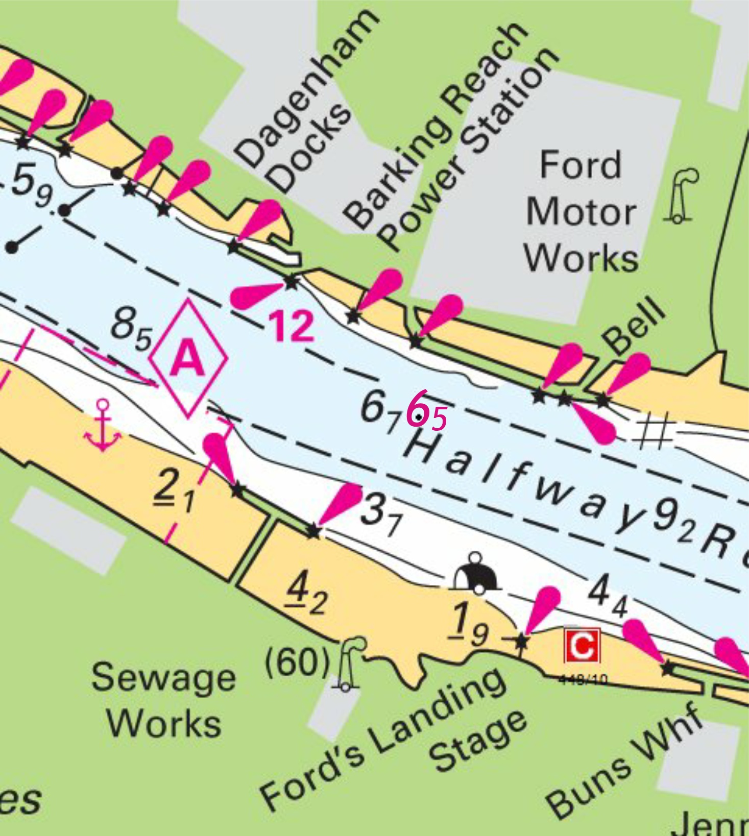
Notice 1062 - Source: Port of London Authority Charts 2151 and 2484 (panel A, Hole Haven to Purfleet) ETRS89 DATUM Insert depth, 58 at 51° 29´·034N., 0° 13´·026E. Delete depth, 65 at 51° 29´·046N., 0° 12´·959E. Chart 2151 (Inset A) ETRS89 DATUM Insert depth, 65 at (a) 51° 30´·669N., 0° 08´·992E. Delete depth, 66, close NE of: (a) above Chart 2484 (panel B, Purfleet to London Bridge) ETRS89 DATUM Insert: depth 58 at (a) 51° 29´·03N., 0° 13´·03E. depth 65 at 51° 30´·67N., 0° 08´·99E. Delete depth, 65 , close NE of: (a) above |
Affects: UKHO Admiralty Charts: 2151 and 2484 including panels. Imray Charts: C2 UKHO Leisure Folios: 5606.14 Two small reductions in depth on the Thames: the first at Purfleet just above Dartford Creek, the second in Halfway Reach opposite the Ford Motor Works. Neither reduction is likely to trouble leisure craft.
Image courtesy of Imray Charts and Meridien ID10. Left click to enlarge, right click to download. |
|
Week 10 |
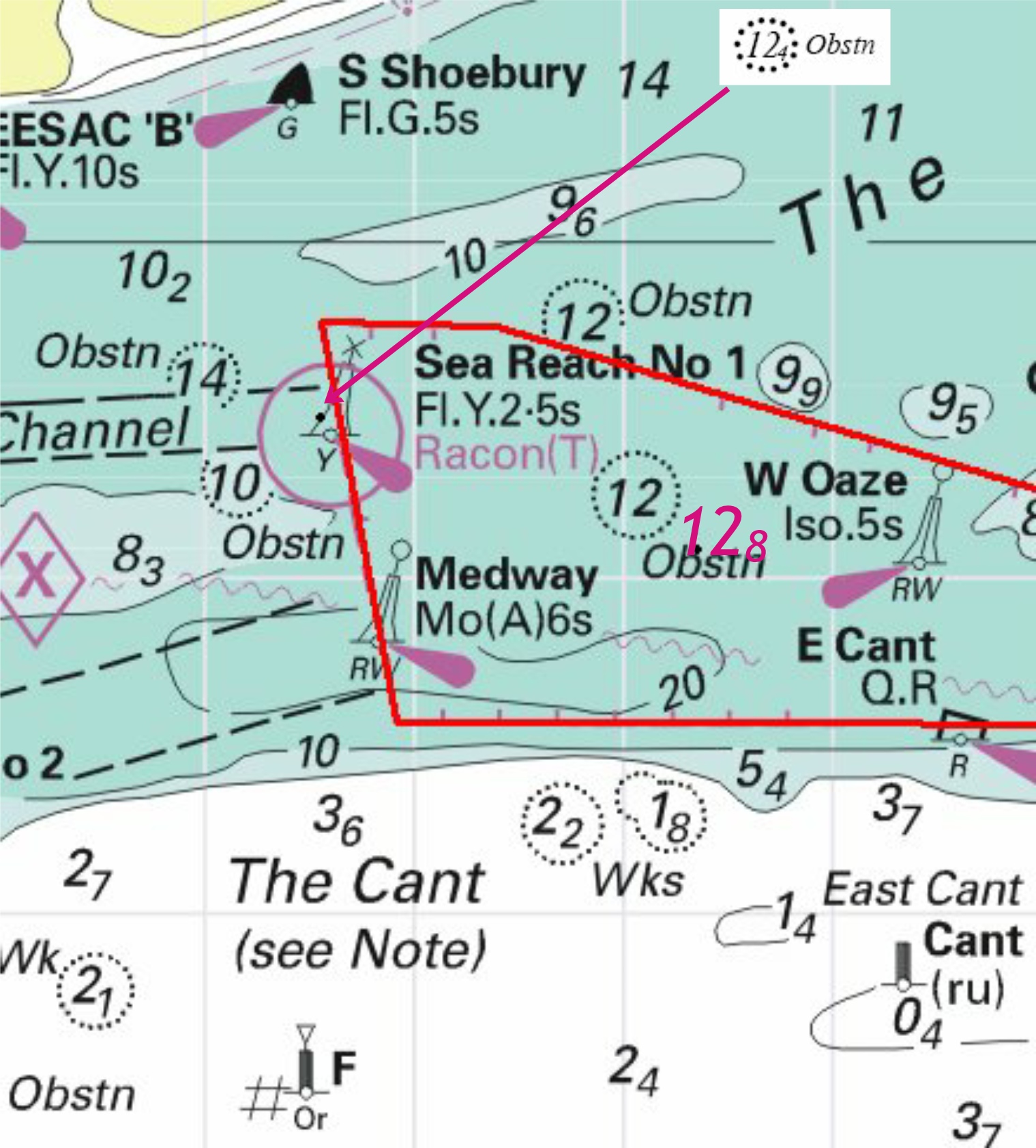
Notice 1063 - Source: Port of London Authority Chart 1185 ETRS89 DATUM Insert:
depth, 128 at (a) 51° 29´·08N., 0° 54´·35E. Amend dredged depth to, 14·0m (2014), centred on: 51° 30´·15N., 0° 35´·50E. and 51° 29´·35N., 0° 48´·65E. Delete: depth, 112 , close SW of: (a) above depth, 118 at 51° 30´·09N., 0° 37´·02E. depth, 117 at 51° 30´·10N., 0° 37´·25E. Chart 1186 (panel A, Canvey Island to Coalhouse Point) ETRS89 DATUM Amend dredged depth to, 14·0m (2014), centred on: 51° 30´·15N., 0° 31´·7E. and 51° 30´·15N., 0° 35´·3E. Charts 1607 and 1609ETRS89 DATUM Insert:
depth, 127 at (a) 51° 29´·04N., 0° 54´·51E. Amend dredged depth to, 14m (2014), centred on: 51° 29´·25N., 0° 53´·60E. Delete: depth, 114, close N of: (a) above depth, 112 , close W of: (a) above Chart 2484 (panel A, Hole Haven to Purfleet) ETRS89 DATUM Amend dredged depth to, 14·0m (2014), centred on: 51° 30´·2N., 0° 32´·2E. |
Affects: UKHO Admiralty Charts: 1185, 1186, 1607, 1609 and 2484 Imray Charts: C1 UKHO Leisure Folios: 5606.2, 5606.7 Imray Leisure Folios: 2100.1, 2100.2 Further depth changes as a result of the recent dredging programme for the London Gateway. First an obstruction right by the Sea Reach No 1 buoy and a new depth due west of the W. Oaze safe water buoy. At over 12m, neither will trouble leisure craft. The alteration to the dredged depth is for the centre of the Yantlet Channel.
Image courtesy of Imray Charts and Meridien ID10. Left click to enlarge, right click to download. |
|
Week 10 |
Notice 1086 - Source: French Notice 6/45/14 Chart 323 ETRS89 DATUM Replace: depth, 205, with depth, 195, enclosed by 20m contour at 51°06´·96N., 1°46´·70E. depth, 161, with depth, 156 at 51°04´·60N., 1°45´·51E. Chart 1406 WGS84 DATUM Insert: depth, 195, and extend 20m contour W to enclose (a) 51°06´·96N., 1°46´·70E. depth, 156 at (b) 51°04´·60N., 1°45´·51E. Delete: depth, 199, close E of: (a) above depth, 158, close E of: (b) above Chart 1610 ETRS89 DATUM and Chart 2449 WGS84 DATUM Insert depth, 195, and extend 20m contour W to enclose (a) 51°06´·96N., 1°46´·70E. Replace depth, 16, with depth, 156 at (b) 51°04´·60N., 1°45´·51E. Delete depth, 199 , close E of: (a) above Chart 1892 ETRS89 DATUM Insert depth, 195, and extend 20m contour W to enclose (a) 51°06´·96N., 1°46´·70E. Replace depth, 16, with depth, 156 at (b) 51°04´·60N., 1°45´·51E. |
Affects: UKHO Admiralty Charts: 323, 1406, 1610, 1892 and 2449. Imray Charts: C8 UKHO Leisure Folios: 5605.1 (B), 5605.2, 5606.1 Imray Leisure Folios: 2100.6. This longish correction amounts to two new depths in the NE heading TSS, between the Sandettie and Ruytingen. These will not trouble leisure craft.
Image courtesy of Imray Charts and Meridien ID10. Left click to enlarge, right click to download. |
|
Week 9 |
Notice 879 - Source: FPV Morven Chart 323 ETRS89 DATUM Replace: depth, 206 , with depth, 196 , enclosed by 20m contour at 50° 59´·02N., 1° 24´·84E. depth, 27, with depth, 23 at 51° 09´·29N., 1° 44´·53E. depth, 255 , with depth, 245 at 51° 21´·16N., 1° 59´·64E. Chart 536 ETRS89 DATUM Insert depth, 25 at (a) 50° 47´·05N., 1° 01´·04E. Delete depth, 275 , close NE of: (a) above Charts 1406 and 2449 WGS84 DATUM and 1610 ETRS89 DATUM Insert depth, 23 at (a) 51° 09´·29N., 1° 44´·53E. Replace: depth, 206, with depth, 196 , enclosed by 20m contour at 50° 59´·02N., 1° 24´·84E. depth, 255 , with depth, 245 at 51° 21´·16N., 1° 59´·64E. Delete depth, 26, close NE of: (a) above Chart 1892 ETRS89 DATUM Insert depth, 25 at (a) 50° 47´·05N., 1° 01´·04E. Replace: depth, 206 , with depth, 196, enclosed by 20m contour at 50° 59´·02N., 1° 24´·84E. depth, 27, with depth, 23 at 51° 09´·29N., 1° 44´·53E. Delete depth, 275, close NE of: (a) above Chart 2451 WGS84 DATUM Insert depth, 25 at 50° 47´·05N., 1° 01´·04E. Replace depth, 206 , with depth, 196, enclosed by 20m contour at 50° 59´·02N., 1° 24´·84E. |
Affects: UKHO Admiralty Charts: 323, 536, 1406, 1610, 1892, 2449 and 2451 Imray Charts: C8 UKHO Leisure Folios: 5605.1, 5605.2, 5605.7 Imray Leisure Folios: 2100.6 A series of revised depths at eclectic positions in the Eastern channel and near the Sandettie. None of these revised depths should trouble leisure craft.
Image courtesy of Imray Charts and Meridien ID10. Left click to enlarge, right click to download. |
|
Week 9 |
Notice 880 - Source: FPV Morven Chart 1183 ETRS89 DATUM Replace depth, 146, with depth, 153 at 51° 51´·85N., 1° 35´·29E. Delete depth, 136 at 51° 51´·09N., 1° 36´·65E. Chart 1610 ETRS89 DATUM Delete depth, 136 at 51° 51´·09N., 1° 36´·65E. Chart 1975 ETRS89 DATUM Replace depth, 144, and associated 15m contour, with depth, 159 at 51° 51´·19N., 1° 36´·15E. Delete depth, 136 at 51° 51´·09N., 1° 36´·65E. Charts 2052 and 2692 ETRS89 DATUM Replace: depth, 146, and associated 15m contour, with depth, 153 at 51° 51´·85N., 1° 35´·29E. depth, 144 , and associated 15m contour, with depth, 159 at 51° 51´·19N., 1° 36´·15E. Charts 2052 ETRS89 DATUM Also delete depth, 136 at 51° 51´·09N., 1° 36´·65E. Chart 2692 ETRS89 DATUM Also delete depth, 147, and associated 15m contour at 51° 51´·34N., 1° 36´·19E. |
Affects: UKHO Admiralty Charts: 1183, 1610, 1975, 2052 and 2692 Imray Charts: C1 UKHO Leisure Folios: 5607.1, 5605.2, 5605.7 Imray Leisure Folios: 2001.1 Two changes in depths at the Sunk Inner Precautionary Area. These are at a depth (and in a position) that is unlikely to affect leisure craft.
Image courtesy of Imray Charts and Meridien ID10. Left click to enlarge, right click to download. |
|
Week 9 |
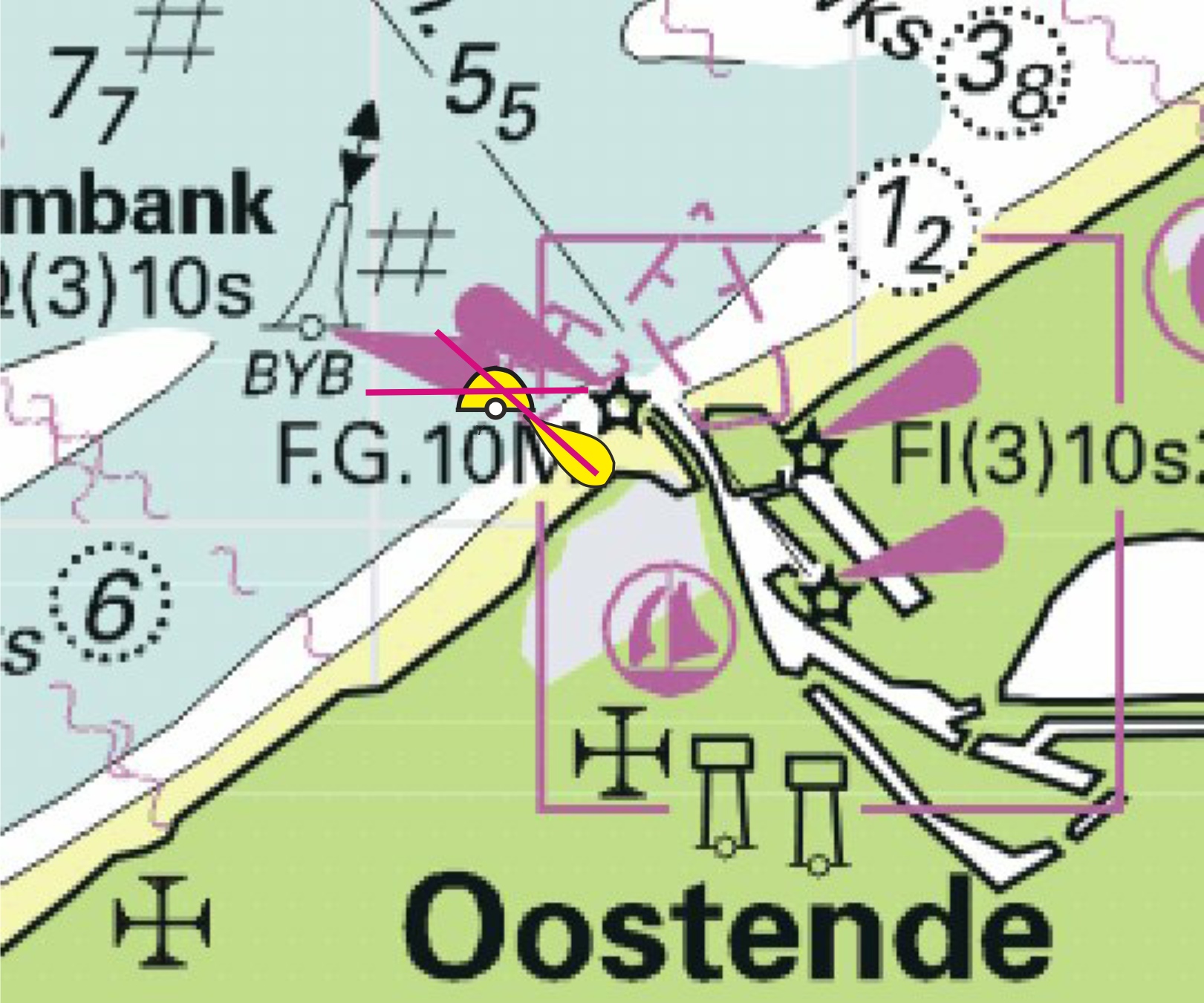
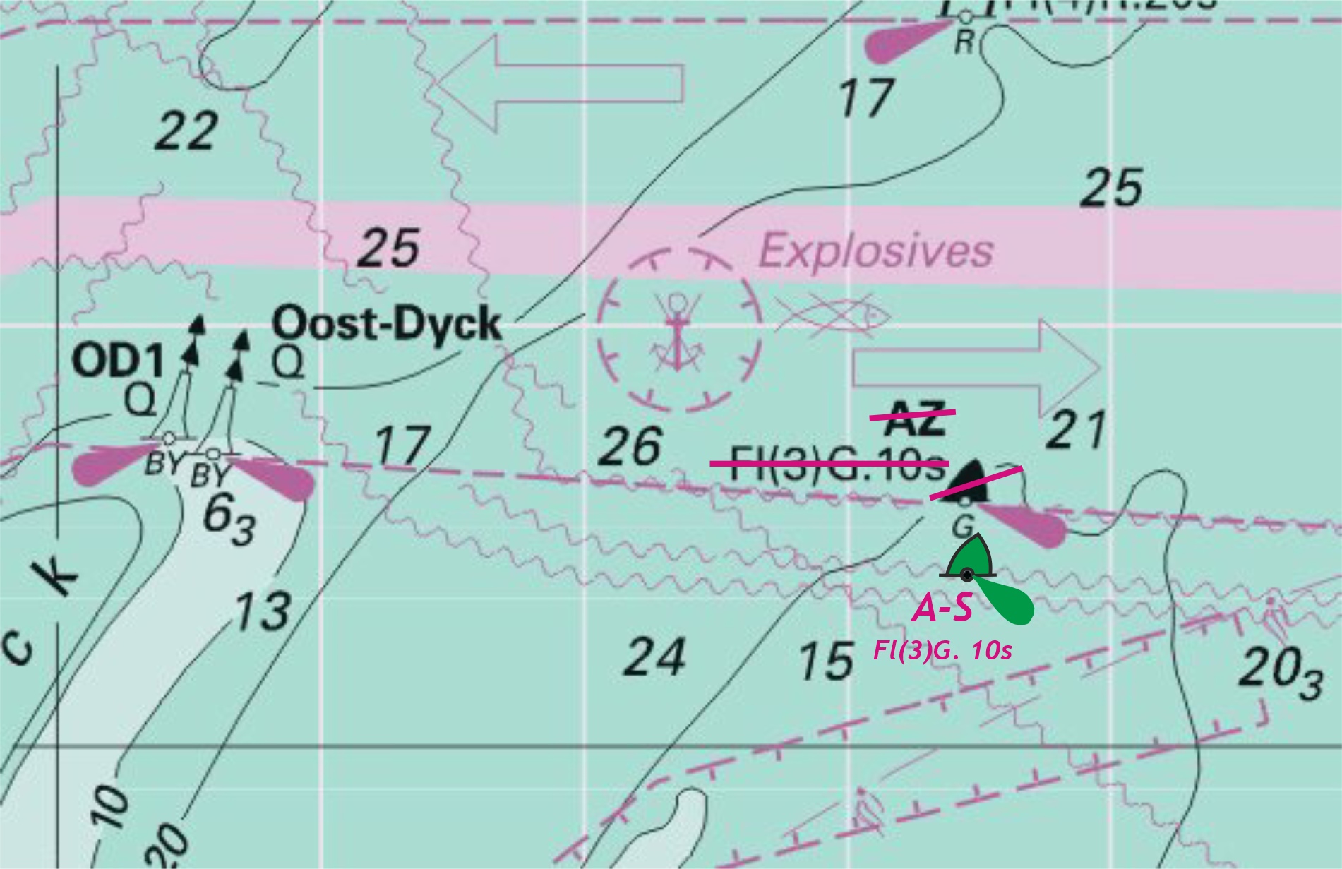
Notice 882 - Source: Belgian Notices 19/289/13, 2/44/14 and 2/48/14 Charts 1406 and 2449 WGS84 DATUM Insert Delete Charts 1872 (panel B, Oostende), 1873 (panel A, Oostende) and 1874 WGS84 DATUM Delete limit of restricted area, pecked line, joining: 51° 14´·26N., 2° 55´·40E. (shore) 51° 14´·25N., 2° 55´·36E. 51° 14´·38N., 2° 55´·29E. 51° 14´·46N., 2° 55´·19E. 51° 14´·58N., 2° 55´·06E. 51° 14´·62N., 2° 55´·10E. (N border) and 51° 14´·62N., 2° 55´·54E. (N border) 51° 14´·42N., 2° 55´·70E. 51° 14´·27N., 2° 55´·72E. (shore) symbol, entry prohibited, centred on: 51° 14´·47N., 2° 55´·34E. Charts 1872 and 1873 WGS84 DATUM Insert Delete limit of restricted area, entry prohibited, pecked line, joining: 51° 14´·26N., 2° 55´·40E. (shore) 51° 14´·38N., 2° 55´·29E. 51° 14´·58N., 2° 55´·06E. 51° 14´·84N., 2° 55´·36E. 51° 14´·43N., 2° 55´·69E. 51° 14´·29N., 2° 55´·70E. (shore) |
Affects: UKHO Admiralty Charts: 1406, 1872, 1873, 1874 and 2449 Imray Charts: C30, C30C UKHO Leisure Folios: 5605.12, 5606.1. Imray Leisure Folios 2100.6 Works to the east of the Ostend entrance have been completed and the prohibition zone removed. The port hand buoy (AZ) marking the end of the TSS Oost-
Image courtesy of Imray Charts and Meridien ID10. Left click to enlarge, right click to download. |
|
Week 8 |
No UKHO Notices affecting monitored areas |
|
|
Week 7 |
No UKHO Notices affecting monitored areas |
|
|
Week 6 |
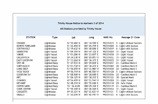
Automatic Identification System (AIS) - The General Lighthouse Authorities¹ (GLA) have commenced roll out of AIS AtoN at selected fixed and floating stations on the coasts of Great Britain and Ireland. It is considered appropriate to remind mariners of the purpose of AIS AtoN and what they may expect to see on some of the available displays. It is important to bear in mind that the information available to mariners will be dependent on their display system and not all transmitted information may be displayed. AIS Transmissions are currently exhibited from the Trinity House stations in the download opposite. Displays & Symbology The IMO mandatory carriage requirement for Class A² AIS display is the Minimum Keyboard Display which displays the data in alphanumeric form. It is important to bear in mind that not all vessels are equipped with AIS. Of those vessels that are AIS equipped the displays available can range from no display on some Class B² units, through the mandatory Class A MKD, to full ECDIS and Radar overlay. In the absence of ECDIS or Radar overlay users will not be able to fully utilise AIS AtoN functionality. There is also a variance on information that will be displayed by different manufacturers on ECDIS or Radar equipment. The symbology that may be displayed on nautical charts, display systems and MKD is summarised below. Nautical Charts - Display Systems - Range Bearing Name XX.XX XXX.X XXXXXXXXX XX.XX XXX.X XXXXXXXXX XX.XX XXX.X XXXXXXXXX Latitude XXX XX.XXX Longitude XXX XX.XXX
Minimum Keyboard Display - Message Types. AIS stations provided by the GLA will transmit Message 21 – Aids to Navigation Report. This message will provide details of the Name, MMSI, Type and Position of the AtoN. In addition there will be an indication if the AtoN is off station, and of the status of the light, Racon or other equipment. Other messages providing additional data may occasionally be broadcast. These would normally be Binary Messages 6/8 or Short Safety Related Messages 12/14. Details of AIS AtoN are set out in Volume 2 of the Admiralty List of Radio Signals. Feedback Mariners are requested to contact the General Lighthouse Authorities regarding their experience of AIS and in particular the extent to which AIS AtoN data is available to them |
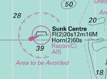
Trinity House Notice To Mariners No.3/14 B2, C1, D1, E1, F2, G1 This notice lists all the Aids to Navigation (AtoN) currently displaying AIS courtesy of Trinity House. CTTE has extracted the list from the notice and placed in a PDF for download.
This contains the Lat/Long and message characteristics of each AtoN. Please download here. The AtoN affected in our area are: Cromer North Foreland Southwold Sandettie Varne East Goodwin Spit NE Goodwin SW MPC Newarp Outer Sand Sunk Centre |
|
Week 5 |
Notice 479 - Source: Port of London Authority Chart 1186 (panel A, Canvey Island to Coalhouse Point) ETRS89 DATUM Insert Delete former West Blyth light- Chart 2484 (panel A, Hole Haven to Purfleet) ETRS89 DATUM Move |
Affects: UKHO Admiralty Charts: 1186 and 2484 Imray Charts: C2 UKHO Leisure Folios: 5606.13, 5606.14 The nomadic West Blyth PHB is now repositioned further to the south west. Readers will recall that the light characteristics were altered to QR vide NtM 5225 of 2013 (week 50).
Image courtesy of Imray Charts and Meridien ID10. Left click to enlarge, right click to download. |
|
Week 5 |
Notice 425 - Source: Cefas Charts 1408, 1631 WGS84 DATUM, 1504 ETRS89 DATUM Delete:
(b) 52° 33´·4N., 2° 46´·4E.
Chart 1503 ETRS89 DATUM Delete:
|
Affects: UKHO Admiralty Charts: 1408, 1504 and 1631 Imray Charts: C28 UKHO Leisure Folios: 5614.3 This is a partial cancellation of Notice to Mariners 180 of 2013 (Week 2). The obstructions were at a depth that would be unlikely to trouble leisure craft and the buoys are now removed.
Image courtesy of Imray Charts and Meridien ID10. Left click to enlarge, right click to download. |
|
Week 4 |
No UKHO Notices affecting monitored areas |
|
|
Week 3 |
Notice 173 - Source: rv Belgica Chart 1543 ETRS89 DATUM Insert # at 52° 19´·34N., 2° 02´·37E. |
Affects: UKHO Admiralty Charts: 1543 Imray Charts: C25, C28 UKHO Leisure Folios: 5614.1 This new foul is in over 30 metres of water and consequently is unlikely to trouble leisure craft.
Image courtesy of Imray Charts and Meridien ID10. Left click to enlarge, right click to download. |
|
Week 3 |
Notice 201 - Source: Dover Harbour Board Chart 1698 ETRS89 DATUM Insert: depth, 32 (a) at 51° 06´·879N., 1° 18´·948E. depth, 28 (b)at 51° 06´·888N., 1° 18´·867E. Delete: depth, 4, close E of: (a) above depth, 35 , close E of: (b) above |
Affects: UKHO Admiralty Charts: 1698 Imray Charts: C8D UKHO Leisure Folios: 5605.14 Imray Leisure Folios: 2100.7 These two new depths are in the basin to the west of the dredged channel leading to the marina and in consequence would be unlikely to trouble leisure craft.
Image courtesy of Imray Charts and Meridien ID10. Left click to enlarge, right click to download. |
|
Week 3 |
Notice 214 - Source: Port of London Authority Charts 2484 (panel D, Thames Tidal Barrier) & 3337 (panel B, Thames Tidal Barrier) ETRS89 DATUM Insert depth, 53 at 51° 29´·797N., 0° 01´·728E. Chart 2484 (panel B, Purfleet to London Bridge) ETRS89 DATUM Insert depth 53 (a) 51° 29´·80N., 0° 01´·73E. Delete depth 58 , close SW of: (a) above Chart 3337 ETRS89 DATUM Insert: depth, 45 , and extend 5m contour NE to enclose 51° 30´·168N., 0° 00´·661E. depth, 35 (a) at 51° 29´·835N., 0° 01´·606E. depth, 53 at 51° 29´·797N., 0° 01´·728E. Delete: depth, 43 , close W of: (a) above depth, 49 , close S of: (a) above |
Affects: UKHO Admiralty Charts: 2484 and 3337 Imray Charts: C2 UKHO Leisure Folios: 5606.14 Three new depths in Bugsby and Woolwich Reachs, River Thames. The implication of the sounding in Bugsby’s Reach is that large craft may well be seeking to the eastern side of the channel at this point to avoid the enlarging shallows.
Image courtesy of Imray Charts and Meridien ID10. Left click to enlarge, right click to download. |
|
Week 3 |
Notice 277 - Source: Maritime and Coastguard Agency and Port of London Authority Chart 1183 ETRS89 DATUM Amend legend to, 039°- Charts 1183, 1610 ETRS89 DATUM, 1406 WGS84 DATUM Insert drying height, 0 4 , enclosed by 0m low water line at (a) 51° 47´·45N., 1° 36´·54E. Delete depth, 08 , close NE of: (a) above Charts 1975, 2692 ETRS89 DATUM Insert drying height, 0 4 , enclosed by 0m low water line at 51° 47´·45N., 1° 36´·54E. depth, 02 , and extend 2m approximate contour SE to enclose 51° 47´·57N., 1° 37´·08E. |
Affects: UKHO Admiralty Charts: 1183, 1610, 1406, 1975, 2692 Imray Charts: C1 UKHO Leisure Folios: 5607.2 Imray Leisure Folios: 2000.1 One of which particular note would be worthwhile. New drying height at the Long Sand Head and a greatly reduced depth of 0.2m showing that the Long Sand Head continues to shoal and extend north-
Image courtesy of Imray Charts and Meridien ID10. Left click to enlarge, right click to download. |
|
Week 3 |
Notice 278 - Identification System. Source: Trinity House Charts 1183, 1610, 2052 ETRS89 DATUM, 1406, 1408 and 2182A WGS84 DATUM Insert legend, AIS, at Sunk Centre light- |
UKHO Admiralty Charts: 1183, 1610, 1406, 1408 2052 and 2182A Imray Charts: C1 UKHO Leisure Folios: 5607.2 Imray Leisure Folios: 2000.1 This notice is ‘adding’ AIS at the Sunk Centre light vessel. Slightly mystifying as it is already shown on CTTE Imray charts.
Image courtesy of Imray Charts and Meridien ID10. Left click to enlarge, right click to download. |
|
Week 2 |
No UKHO Notices affecting the monitored areas this week. |
|
|
Week 1 |
No UKHO Notices affecting the monitored areas this week. |
|


 at 52° 48´·26N., 1° 49´·39E.

 with
with  at 53°12´·22N., 0°31´·22E.
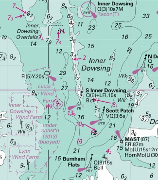
 direction of vessel movement 180°
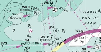

 at 51° 39´·15N., 2° 45´·89E.


 Fl(2)R.10s E Blyth

 Q(6)+LFl.15s South East Leigh
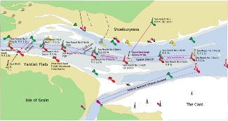
 Fl.Y.2·5s ShSNW


 or
or  at 51° 23´·34N., 2° 26´·48E. and 51° 16´·65N., 2° 27´·09E.
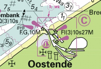

 Fl.Y.5s EESAC ’A’
 at 51°56´·938N., 1°11´·580E.
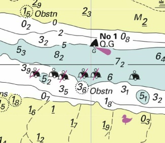
 at 51° 58´·31N., 1° 27´·72E.
 at 51° 58´·30N., 1° 27´·86E.
 at 51° 58´·23N., 1° 27´·94E.
 at 51° 58´·06N., 1° 27´·61E.
 at
at 


 joining:
 Obstn
Obstn  Obstn
Obstn  Obstn
Obstn  Obstn
Obstn 

 at 51° 56´·65N., 1° 18´·97E.
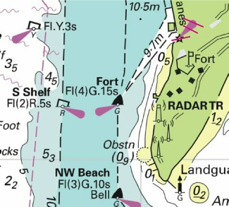


 , joining:


 at 51° 46´·92N., 1° 01´·15E.
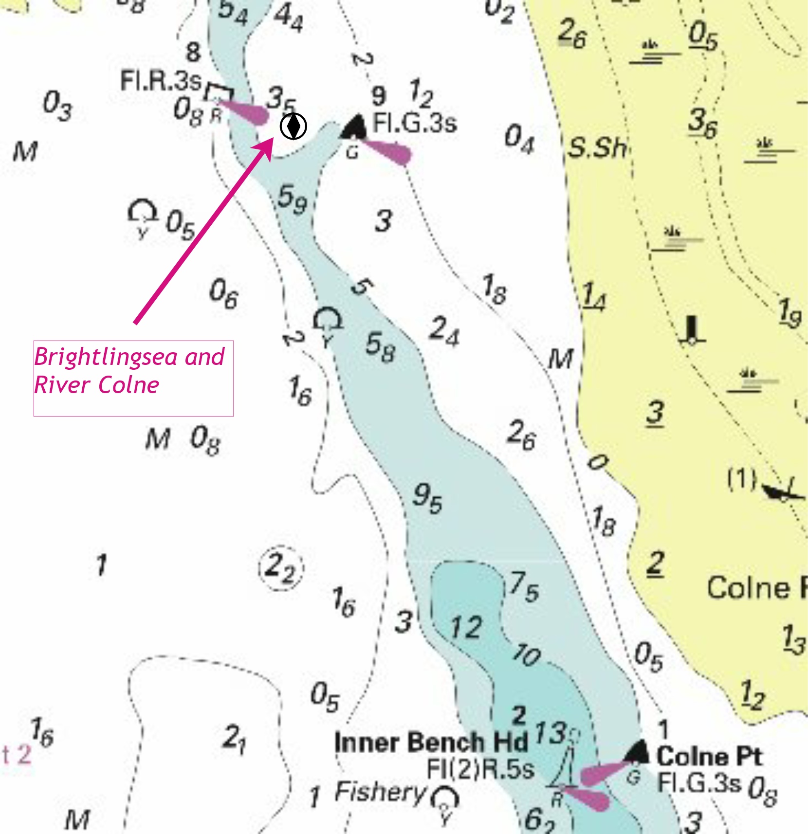

 NW Long Sand (11) with
  , drying height
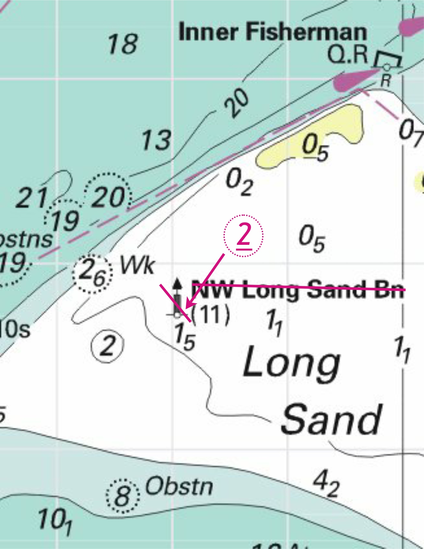


 F.R at
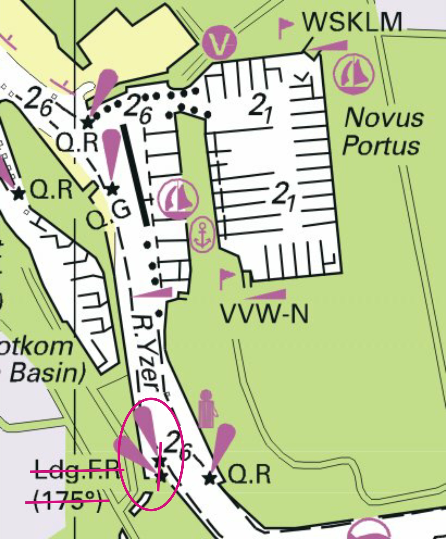


.jpg)


 Fl(5)Y.20s (3 buoys)